© 2019, IRJET | Impact Factor value: 7.211 | ISO 9001:2008 Certified Journal | Page 1614
Tool: Segregration of Bands in Sentinel Data And Calculation of NDVI
Shradha Arvind Jadhav
1, Dr. Prashant Pathavardhan
21Student of Electronics & Communication Engg, G.I.T College Belgaum
2Proffesor of Electronics & Communication Engg, G.I.T College Belgaum
---***---Abstract
- Division of various vegetation types in satellite pictures is a basic issue in remote detecting. This is a direct result of the nearby reflectance between various vegetation types that it makes troublesome isolation of them in satellite pictures. To encourage this issue, diverse satellite inferred vegetation files including: Standardized Distinction Vegetation Record (NDVI), Improved Vegetation File (EVI), and Upgraded Vegetation List 2 (EVI2) were gotten from the Progressed Spaceborne Warm Outflow and Reflection Radiometer (ASTER) and Landsat-5 TM information.Key Words: Satellite pictures, Remote Detecting, Vegetation, NDVI, EVI, EVI2
INTRODUCTION
Late years have seen propels in remote detecting in numerous fields with applications at a spatial scale which go from worldwide to nearby. As an outcome, the need to watch the Earth with increasingly specific and complex sensors and information examination strategies to acquire progressively precise data has expanded. For vegetation discovery and mapping, as a rule vegetation records, for example, Standardized Contrast Vegetation File (NDVI), Improved Vegetation List (EVI), Balanced out Vegetation File (StVI), Changed distinction vegetation file (TDVI) and Upgraded Vegetation List 2 (EVI2) are utilized. The examination researched the use of various vegetation based satellite-determined lists including: NDVI, EVI, and EVI2 for location and mapping from sentinel information.
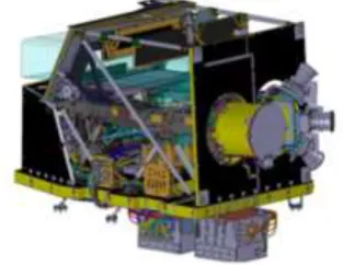
[image:1.595.223.380.625.746.2]For remote detecting applications, band data is of central significance in the period of satellite information investigation and elucidation. The dispatch of Sentinel-2A is a key piece of Worldwide Observing for Condition and Security (GMES) program bolstered by the European Space Organization (ESA) and European Commission (EC) guaranteeing a superior information coherence than other applicable satellites, for example, SPOT and Landsat satellite arrangement, because of its high spatial goals and short return to time. To acquire more recovery data, its Multispectral Instrument (MSI) is a significant segment on this satellite as appeared in Fig. 1. The MSI holds an anastigmatic telescope with three mirrors with an understudy width of about 150mm limiting canteen versatile bends, and the optical structure has been advanced to accomplish cutting edge imaging quality over its 290km field of view. MSI likewise includes 13 phantom groups going from unmistakable, NIR to SWIR at various goals. This setup is chosen as the best trade off between client prerequisites and mission execution. Four groups at 10m goals meet the fundamental necessities for land order; six groups at 20m goals give extra data on vegetation identifying. The staying three groups at 60m add to environmental and geophysical parameters.
© 2019, IRJET | Impact Factor value: 7.211 | ISO 9001:2008 Certified Journal | Page 1615 Notwithstanding characteristics of remote detecting information, grouping calculations are essential to improve characterization correctnesses of maps. As of late, irregular woodlands (RF) is a broadly utilized AI calculation comprising of a gathering of choice trees and it has been an incredibly effective AI calculation for grouping and relapse. Likewise Support vector machine (SVM) has been broadly connected for order. It's a magnificent classifier when the quantity of info highlights is expansive. Inside this structure, the fundamental point of the present examination is to assess the capability of Sentinel-2 information for harvest type characterization.
Literature Survey
Feng CHEN, Ken-ichiro MURAMOTO and Mamoru KUBO[1] A technique to compute NVDI from mountain territory remote detecting information is exhibited in this paper. This technique depends on the light rectification on geologically misshaped satellite pictures. So as to assess the execution of this technique, a test site examine was done on Landsat TM information. The satellite picture splendor esteems rely upon how much brilliant transition is reflected or discharged from an article on the outside of the earth. The transition of occurrence light over a given zone achieves a most extreme when that region is situated opposite to the sun's beams. Band 3 and band 4 were chosen to compute NDVI. The advanced rise model(DEM) information was from the National Topography Foundation of Japan. We utilized DEM and the sunlight based point to compute light.
Tianxiang Zhang, Cunjia Liu, Jinya Su, Wen-Hua Chen et al. [2] Taken a shot at band choice in sentinel-2 satellite for agribusiness application. Instead of grouping dependent on records, this investigates direct characterization utilizing chosen groups of sentinel-2A. In regulated learning, ground truth information is of essential significance with the end goal that diverse methodologies can be assessed and compared. Three strategies are thought about, where the primary methodology uses conventional lists and the last two methodologies embrace explicit groups (Red, NIR, and SWIR) and full groups of on-board sensors, separately. It is demonstrated that a superior order exhibition can be accomplished by straightforwardly utilizing the three chose groups contrasted and the one utilizing lists, while the utilization of every one of the 13 groups can additionally improve the execution. In this manner, it is prescribed the new methodology can be connected for Sentinel-2A picture examination and other wide applications. The proposed technique can be connected to timberland vegetation observing, vegetation physiological status identifying and water system choices.
© 2019, IRJET | Impact Factor value: 7.211 | ISO 9001:2008 Certified Journal | Page 1616 Saket Gowravaram. Pengzhi Tian. Harold Flanagan, Jacksen Goyer. Haiyang Chao[4] This creator centers around the utilization of unmanned airplane framework (UAS) for multispectral remote detecting in post calamity circumstance mindfulness and harm appraisal applications. The Khawk UAS was created as a proving ground for multispectral airborne video procurement. The KHawk Breeze 3 UAS was ended up being a powerful multispectral remote detecting stage. A successful NDVI alignment was proposed and displayed alongside ground and flight tests for approval. The proposed framework was approved in a tornado harm evaluation mission. The produced multispectral orthomosaic maps indicated comparable harvest designs and can be utilized for the forecast of the tornado harm way.
Cynthia. J , Suguna. M , Senthil. S [5] Mapping of water bodies, soil and vegetation area from satellite symbolism has been broadly investigated in the ongoing past. A few methodologies have been created to distinguish water bodies and recognize the dirt kinds from various satellite symbolism differing in spatial, phantom, and transient attributes. Because of the presentation of Another Operational Land Imager (OLI) sensor on Landsat 8 with a high phantom goals and improved flag to-clamor proportion, the nature of symbolism detected is expanded. Its symbolism creates a superior bring about ordering the dirt and water areas The flow examine advances a way to deal with guide water bodies. soil and vegetation locale from a Landsat satellite symbolism utilizing the different handling models. In this examination, to recognize the water district and soil locale. we run with water file, vegetation record and soil file measures. By utilizing reflectance groups, it is anything but difficult to investigate the water. vegetation and soil areas. The proposed technique precisely and immediately segregated the water, vegetation and soil district from other land spread highlights.
M Hasnat Khurshid, Muhammad Faisal Khan[6] High goals satellite symbolism has vast ground inclusion and extraction of principle geological highlights, for example, streams is of fundamental significance for various applications. In this paper, we propose a programmed procedure for extraction of waterways from panchroinatic satellite pictures utilizing an iterative multi goals disintegration of textural highlights, joined with morphological activities. The strategy was utilized for extraction of Kabul stream of Pakistan from high goals SPOT 5 satellite picture. The system utilized multi goals disintegration utilizing DWT of the textural highlights for division. The division was performed on Kabul stream of Pakistan inside a region of 91Km. The division results were generally excellent and the proposed calculation can be utilized adequately for extraction of waterways and channels from high goals panchromatic satellite pictures.
© 2019, IRJET | Impact Factor value: 7.211 | ISO 9001:2008 Certified Journal | Page 1617 arrangement. Scaleup and Speedup proportions were determined so as to confirm the adaptability. The investigations demonstrated that the proposed arrangement scales well.
D.K. Mozgovoy, V.V. Hnatushenko, V.V. Vasyliev[8]Vegetation and water bodies are a crucial component of urban environments, and water mapping is basic for urban and scene arranging and the board. A strategy of mechanized acknowledgment of vegetation and water bodies on the domain of megacitles in satellite pictures of sub-meter spatial goals of the unmistakable and IR groups is proposed. By handling multispectral pictures from the satellite SuperView-1A, vector layers of perceived plant and water objects were acquired. Investigation of the aftereffects of picture handling demonstrated an adequately high exactness of the outline of the limits of perceived articles and a decent detachment of classes. The created technique gives a noteworthy increment of the proficiency and dependability of refreshing maps of huge urban communities while lessening money related expenses. Because of the high level of robotization, the proposed strategy can be actualized as a geo-data web administration working in light of a legitimate concern for a wide scope of open administrations and business foundations. An approach of mechanized acknowledgment of vegetation and water questions in the megacities in satellite pictures of sub-meter spatial goals of the obvious and IR groups is proposed, which makes it conceivable to altogether expand effectiveness and unwavering quality of refreshing maps of substantial urban communities while diminishing monetary expenses. Because of the high level of mechanization, the created approach can be executed as a geo-data web administration, working in light of a legitimate concern for a wide scope of open administrations and business structures.
© 2019, IRJET | Impact Factor value: 7.211 | ISO 9001:2008 Certified Journal | Page 1618
REFERENCES
[1]. Feng CHEN, Ken-ichiro MURAMOTO and Mamoru KUBO, “Calculation of NDVI in mountain areas”, 0-7803-7301-7/01/$10.00 (C) 2001 IEEE.
[2]. Tianxiang Zhang, Cunjia Liu, Jinya Su, Wen-Hua Chen et al. “Band Selection in Sentinel-2 Satellite for Agriculture Applications”, International Conference on Automation & Computing (2017).
[3]. Mehment Dikmen and Ugur Halici, “A Learning-Based Resegmentation Method for Extraction of Buildings in Satellite Images ”, IEEE Geoscience And Remote Sensing Letters. Vol. 11, No. 12, December 2014.
[4]. Saket Gowravaram. Pengzhi Tian. Harold Flanagan, Jacksen Goyer. Haiyang Chao, “UAS- based Multispectral Remote Sensing and NDVI Calculation for Post Disaster Assessment”, 2018 International Conference of Unmanned Aircraft System(ICUAS) Dallas, TX, USA, June 12-15,2018.
[5]. Cynthia. J , Suguna. M , Senthil. S, “Mapping the vegetation soil and water region analysis of Tuticorin district
using Landsat images”, International Journal of Engineering and Technology.
[6]. M Hasnat Khurshid, Muhammad Faisal Khan, “River Extraction From High Resolution Satellite Images”, 2012 5th International Congress on Image and Signal Processing (CISP 2012)
[7]. Tapan Sharma, Dr. Vinod Shokeen, Dr. Sunil Mathur, “Distributed Processing of Satellite Images on Hadoop to Generate Normalized Difference Vegetation Index Images ”, 978-1-5386-4008-1/17/$31.OO ©2017 IEEE
[8]. D.K. Mozgovoy, V.V. Hnatushenko, V.V. Vasyliev, “Automated Recognition Of Vegetation And Water Bodies On The Territory Of Megacities In Satellite Images Of Visible And IR Bands ”, ISPRS Annals of the Photogrammetry, Remote Sensing and Spatial Information Sciences, Volume lV-3, 2018 ISPRS TC Ill Mid-term Symposium “Developments, Technologies and Applications in Remote Sensing”, 7—10 May, Beijing, China.