Éamonn Linehan
A thesis submitted to the University of Dublin, Trinity College
in fulllment of the requirements for the degree of
Doctor of Philosophy (Computer Science)
I, the undersigned, declare that this work has not previously been submitted to this
or any other University, and that unless otherwise stated, it is entirely my own work.
I agree that Trinity College Library may lend or copy this thesis upon request.
Éamonn Linehan
Acknowledgements
Éamonn Linehan
Summary
Mobile context-aware computing is a paradigm in which mobile devices have access to information, known as context, about the situation in which they are being used, and dynamically adapt application behaviour to support user tasks and mobility. A primary concern of mobile context-aware computing is awareness of the physical en-vironment surrounding a user. This concern is addressed through spatial-awareness, where mobile applications employ knowledge about the physical location of real world objects to compute, for example, estimated journey times, routes between activities, perform proximity-based information retrieval, and render map-based interfaces. Geo-graphic Information Systems (GIS) have traditionally performed these operations on static spatial data, vector-based geometry and attributes describing real world objects. However, spatial data and supporting services are conned to central servers, accessible to mobile devices in the form of a static graphic representation via wireless networks.
The range of services that spatially-aware applications on hand-held mobile devices can provide are limited by technical factors such as the inherent unreliability of wi-reless networks and the limited nature of mobile devices in terms of battery power, memory constraints and screen size. Because these limitations are common to all mo-bile applications, a generic model for spatial services is needed that is designed not to overburden the limited resources of mobile devices and is not dependent on continuous network connectivity.
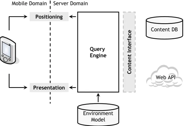
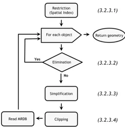
include a multiple representation database designed to approximate continuous scale adaptation with stepped levels of detail. Access to this data structure is facilitated by a hierarchical spatial index that uses minimum bounding boxes to approximate more complex spatial objects. The levels of detail are computed using algorithms that eli-minate objects based on rendered size at particular scales and simplify geometry using shape and location preserving algorithms. Limited processing resources are further pre-served by clipping geometry that extends beyond the viewport of the device to avoid computing projections and rendering coordinates that will not be seen. A graph-based topological representation of spatial data is searched using pluggable graph traversal algorithms with congurable cost functions to provide navigation capabilities.
The increased accessibility of spatial information oered by the model allows for the development of innovative services such as visibility determination, which expands mo-bile context-aware computing's environmental awareness beyond the physical location of real world objects to include the visibility of those objects. Spatial objects within the applications' viewport are ltered based on a eld of view determined by compass direction and the human visual system. The resulting objects are then stored in a depth buer on which a variation of occlusion culling is performed on their bounding volumes to reduce the set of geometry in the buer to a possibly visible set (PVS).
Éamonn Linehan, Shiu Lun Tsang, and Siobhán Clarke. Supporting Context-Awareness: A Taxonomic Review. Technical Report, Department of Computer Science, Trinity College Dublin, TCD-CS-2008-37, http://www.cs.tcd.ie/publications/tech-reports/reports.08/TCD-CS-2008-37.pdf.
Cormac Driver, Éamonn Linehan, Mike Spence, Shiu Lun Tsang, Laura Chan and Siobhán Clarke. Facilitating Dynamic Schedules for Healthcare Professionals. In Pro-ceedings of the 1st International Conference on Pervasive Computing Technologies for Healthcare, Innsbruck, Austria, 2006. IEEE.
Cormac Driver, Éamonn Linehan and Siobhán Clarke. A Framework for Mobile, Context-Aware Trails-based Applications: Experiences with an Application-led Ap-proach. In Workshop 1 - What Makes for Good Application-led Research in Ubiqui-tous Computing?, 3rd International Conference on Pervasive Computing (PERVA-SIVE 2005), Munich, Germany, 2005.
Contents
Acknowledgements iii
Abstract iii
Publications Related to this Ph.D. vi
List of Tables xii
List of Figures xiii
List of Listings xvi
Chapter 1 Introduction 1
1.1 Background . . . 1
1.1.1 Mobile Devices . . . 2
1.1.2 Wireless Networks . . . 5
1.1.3 Spatial Information . . . 5
1.2 Motivation . . . 9
1.3 A Model for Mobile Spatial Services . . . 14
1.3.1 Constant Availability of Spatial Services . . . 15
1.3.2 Spatial Complexity Reduction . . . 16
1.3.3 Spatial Services . . . 17
1.3.4 Visibility . . . 19
1.3.5 Genericity . . . 20
1.4 Contribution . . . 20
2.1 Spatial Services for Mobile Computing . . . 24
2.1.1 Cyberguide . . . 25
2.1.2 Deep Map . . . 28
2.1.3 CRUMPET . . . 30
2.1.4 Nexus . . . 33
2.1.5 Lol@ . . . 35
2.1.6 GiMoDig . . . 37
2.1.7 M-Spaces . . . 40
2.1.8 GinisMobile . . . 42
2.1.9 Point to Discover . . . 44
2.1.10 Summary . . . 48
2.2 Commercial GIS & Web Mapping . . . 50
2.2.1 ArcGIS Mobile SDK . . . 51
2.2.2 Web Mapping . . . 53
2.3 Chapter Summary . . . 55
Chapter 3 Design 59 3.1 Model for Mobile Spatial Middleware . . . 61
3.1.1 System Model Assumptions . . . 62
3.1.2 Spatial Data Dissemination . . . 63
3.2 Local Environment Model . . . 66
3.2.1 Multiple Representation Database . . . 66
3.2.2 Spatial Index . . . 71
3.2.3 Model-Oriented Generalisation . . . 73
3.3 Spatial Middleware Services . . . 80
3.3.1 Analysis & Requirements . . . 80
3.3.2 Adaptable Map Rendering . . . 81
3.3.3 Spatial Reasoning . . . 83
3.3.4 Coordinate Transformation . . . 86
3.3.5 Route Generation . . . 89
3.4.1 Pluggable Component Model . . . 100
3.4.2 Framework Summary . . . 103
3.5 Chapter Summary . . . 104
Chapter 4 Implementation 105 4.0.1 Platform . . . 107
4.0.2 Packages . . . 107
4.0.3 Hermes Integration . . . 109
4.1 Spatial Data Model . . . 113
4.1.1 ESRI Shapeles . . . 114
4.1.2 Multi-Scale Shapele . . . 115
4.1.3 MRDB Spatial Data Retrieval . . . 116
4.1.4 Spatial Query Interface . . . 118
4.1.5 Generalisation . . . 121
4.2 Spatial Services . . . 125
4.2.1 Visibility Determination . . . 125
4.3 Framework . . . 132
4.3.1 Pluggable Component Model . . . 133
4.3.2 Conguration File . . . 134
4.4 Chapter Summary . . . 137
Chapter 5 Evaluation 139 5.1 Spatial Service Performance . . . 141
5.1.1 Methodology . . . 142
5.1.2 Data Set . . . 144
5.1.3 Results . . . 144
5.1.4 Analysis . . . 153
5.2 Energy Consumption . . . 154
5.2.1 Methodology . . . 156
5.2.2 Results . . . 163
5.2.3 Analysis . . . 169
5.3.2 Analysis . . . 174
5.4 Evaluation Summary . . . 175
Chapter 6 Conclusions and Future Work 178 6.1 Achievements . . . 178
6.2 Future Work . . . 181
6.2.1 Energy Consumption of P2P Overlays . . . 182
6.2.2 Partitioning of Application Logic . . . 182
6.2.3 Data Structures for Flash Memory . . . 183
6.2.4 Spatial Data Integration . . . 184
6.3 Chapter Summary . . . 184
Appendix A Further Implementation Detail 186 A.1 Framework Conguration File . . . 186
A.2 Benchmark Harness . . . 189
A.3 Energy Evaluation User Simulator . . . 191
A.4 Screenshots . . . 193
Appendix B Source Code Measurements 198 Appendix C Glossary 200 C.1 Terminology . . . 200
C.2 Symbols . . . 201
Appendix D API 203 D.1 Package ie.tcd.cs.dsg.hermes.gis.generalisation.simplication . 203 D.2 Package ie.tcd.cs.dsg.hermes.gis.io . . . 209
D.3 Package ie.tcd.cs.dsg.hermes.gis.io.multiscale . . . 243
D.4 Package ie.tcd.cs.dsg.hermes.gis.event . . . 250
D.5 Package ie.tcd.cs.dsg.hermes.gis . . . 263
D.6 Package ie.tcd.cs.dsg.hermes.gis.geometry . . . 269
D.7 Package ie.tcd.cs.dsg.hermes.gis.ui . . . 290
D.10 Package ie.tcd.cs.dsg.hermes.gis.layer . . . 302
D.11 Package ie.tcd.cs.dsg.hermes.gis.projection.model . . . 314
D.12 Package ie.tcd.cs.dsg.hermes.gis.graph . . . 317
D.13 Package ie.tcd.cs.dsg.hermes.gis.graph.traverse . . . 327
D.14 Package ie.tcd.cs.dsg.hermes.gis.projection . . . 331
D.15 Package ie.tcd.cs.dsg.hermes.gis.query . . . 344
D.16 Package ie.tcd.cs.dsg.hermes.gis.index . . . 358
D.17 Package ie.tcd.cs.dsg.hermes.gis.ui.event . . . 363
D.18 Package ie.tcd.cs.dsg.hermes.gis.generalisation.clipping . . . 364
D.19 Package ie.tcd.cs.dsg.hermes.gis.ui.style . . . 371
List of Tables
2.1 Spatial services for mobile applications . . . 48
3.1 Spatially-aware mobile applications . . . 80
4.1 ESRI Shapele les . . . 115
4.2 Extended ESRI Shapele le components . . . 115
4.3 Extended Shapele main le header . . . 116
4.4 Pluggable components . . . 135
5.1 Test spatial data set . . . 145
5.2 Local versus remote execution of tasks . . . 154
5.3 HP iPAQ hx2490 Pocket PC specications (Source: [104]) . . . 157
List of Figures
1.1 Background technologies . . . 2
1.2 Types of spatial data model . . . 7
1.3 Categorisation of GIS spatial operations . . . 8
1.4 Comparison of architectural models . . . 15
1.5 Middleware model for spatial services . . . 18
1.6 Illustration of visibility culling techniques . . . 19
2.1 Technologies related to this thesis. . . 23
2.2 The Cyberguide MessagePad interface (Source: Abowd et al. [2]) . . . 25
2.3 Deep Map interface (Source: Kray [120]) . . . 28
2.4 The CRUMPET welcome page (Source: [206] Figure 4.) . . . 30
2.5 The Nexus architecture (Redrawn from [82], Figure 1) . . . 34
2.6 Lol@ map interface (Source: Umlauft et al. [223]) . . . 35
2.7 Simplied GiMoDig architecture (Source: Sarjakoski et al. [222]) . . . 38
2.8 GinisMobile architecture (Source: Predic et al. [183]) . . . 43
2.9 Point to Discover application framework architecture . . . 45
2.10 P2D LVis billboard principle . . . 45
2.11 ArcGIS Mobile SDK architecture (Source: ArcGIS Mobile 9.3 [70]) . . 52
2.12 Google Maps for the iPhone 3G (Source: Apple.com [12]) . . . 54
3.1 Mapping research questions to design elements . . . 60
3.2 The Hermes mobile application framework architecture . . . 63
3.3 Architectural model for mobile spatial middleware . . . 65
3.4 Multiple representation database hierarchy . . . 67
3.7 Illustration of R-Tree spatial index hierarchy for 2D geometry . . . 72
3.8 Generalisation algorithm ow chart . . . 75
3.9 Elimination generalisation step . . . 76
3.10 Simplication generalisation step . . . 77
3.11 Clipping generalisation step . . . 78
3.12 Adaptable map rendering layers . . . 82
3.13 Geometry model showing spatial relationship functions . . . 84
3.14 Supported geometry types . . . 86
3.15 Two-step coordinate transformation algorithm . . . 87
3.16 Coordinate transformation design detail . . . 88
3.17 Topological model building . . . 90
3.18 Graph-based route generation . . . 90
3.19 View frustum culling perception model design . . . 94
3.20 Depth buer distance comparisons . . . 95
3.21 Back face occlusion culling . . . 97
3.22 Ray casting from a single object . . . 97
3.23 Ray casting visibility algorithm ow chart . . . 98
3.24 Pluggable component model . . . 101
3.25 Pluggable component model extension points . . . 102
4.1 Implementation platform . . . 108
4.2 Architecture overview package diagram with dependencies . . . 108
4.3 Non-commenting source statements per package . . . 110
4.4 Multi-scale retrieval . . . 117
4.5 Spatial query class diagram . . . 119
4.6 Elimination ShapeList lter class diagram . . . 122
4.7 2D geometry simplication class diagram . . . 123
4.8 Geometry clipping class diagram . . . 124
4.9 Class diagram for DepthBuffer . . . 128
4.10 Backface occlusion culling algorithm activity diagram . . . 130
4.11 Ray casting visibility determination activity diagram . . . 131
5.2 Eect on standard deviation as number of samples increases . . . 144
5.3 Map interface responsiveness . . . 146
5.4 Spatial data format performance . . . 147
5.5 MRDB memory usage . . . 148
5.6 Relative performance of generalisation steps . . . 149
5.7 Map projection algorithm performance . . . 150
5.8 Visibility determination example . . . 151
5.9 Visibility algorithm performance . . . 152
5.10 Energy evaluation user bot . . . 158
5.11 Spatially-aware application map interface . . . 158
5.12 Framework extensions for server-based spatial services . . . 159
5.13 Energy consumption experimental setup . . . 161
5.14 acbTaskMan PDA power meter (Source: [3]) . . . 161
5.15 CPU usage over time (middleware) . . . 163
5.16 Memory usage over time (middleware) . . . 164
5.17 Network activity over time (middleware) . . . 165
5.18 Power drain over time (middleware) . . . 165
5.19 CPU activity over time (server-based) . . . 167
5.20 Memory usage over time (server-based) . . . 168
5.21 Network activity over time (server-based) . . . 168
5.22 Power consumption over time (server-based) . . . 169
5.23 Comparison of power consumption . . . 170
5.24 Case study application implementation . . . 173
5.25 Where Are We ? case study application interface . . . 175
A.1 Zoom map interface screenshot . . . 194
A.2 Rotating map interface screenshot (rotating clockwise from top left) . . 195
A.3 Pan map interface screenshot . . . 196
List of Listings
3.1 Pseudocode for a general occlusion culling algorithm. . . 96
4.1 Hermes basic conguration parameters . . . 110
4.2 Instructing Hermes to use a local context source (GPS sensor) . . . 111
4.3 Acquiring and sharing context in Hermes . . . 112
4.4 Retrieving location context from Hermes . . . 113
4.5 Building a spatial query . . . 120
4.6 Text representation of a spatial query . . . 120
4.7 The accept() method of the ViewFrustumCulling lter . . . 126
4.8 The system class loader being invoked to instantiate a component . . . 133
A.1 The gis.properties conguration le. . . 186
A.2 The Harness implementation . . . 189
Chapter 1
Introduction
This thesis investigates architectural models for spatially-aware middleware, including the design of a set of algorithms that provide reusable lightweight variants of spatial services on hand-held mobile devices. The provision of such services on mobile devices is limited by technical factors, such as periodic disconnection from wireless networks, the inherent unreliability of wireless networks and the limited nature of mobile devices in terms of battery power, memory constraints and screen size. The thesis describes algorithms designed to minimise the processing time and power consumed on mobile devices while providing uninterrupted access to spatially-aware application services. This chapter provides the background and motivation to this work, introduces an ar-chitectural model for spatial middleware services and concludes with the contributions and the layout of the thesis.
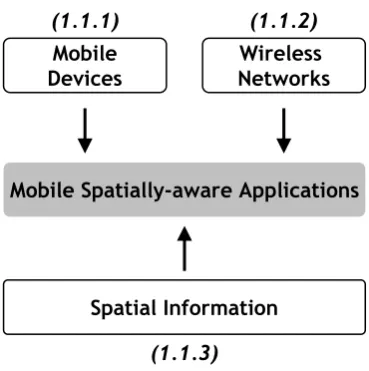
1.1 Background
Wireless Networks Mobile
Devices
Mobile Spatially-aware Applications
Spatial Information
(1.1.2) (1.1.1)
[image:18.595.227.412.77.263.2](1.1.3)
Figure 1.1: Background technologies
1.1.1 Mobile Devices
Hand-held mobile computers are small, portable devices that allow the user to move away from the traditional desktop environment, while retaining the ability to under-take computing tasks. Hand-held mobile computing devices include smart phones, pocket PCs and personal digital assistants (PDAs). Laptops and ultra mobile PCs can be considered a dierent class of mobile device and are explicitly excluded from consideration as they exhibit dierent characteristics to hand-held devices, demanding their own set of requirements and approaches.
Hand-held mobile computing devices dier from their desktop counterparts in terms of form factor, architecture, failure semantics and usage patterns [198]. The form factor of hand-held mobile devices is dened by the need to t comfortably into one's pocket. Devices are intended either to be operated by one hand or to be held in one hand and operated with another (most PDAs fall into this category). The most signicant architectural dierences between mobile devices and desktop computers is their use of memory and integrated sensors. On a desktop computer, RAM and long-term storage space are separated, whereas, on mobile devices, RAM is often used both as working memory and long-term storage, limiting its availability to applications.
type of which is GPS, [66] are being used to determine location. Examples of other po-sitioning systems include infrared, Bluetooth, ultrasonic beaconing [232, 233], wireless network ngerprinting [31] and network positioning based on cellular base station time of ight measurements. Other sensors commonly available on mobile devices include microphones, cameras, touch, and light sensors.
Mobile devices also have dierent failure semantics than their desktop counterparts. Unexpected failures are common. For example, communications failures occur often, users can remove the battery midstream, or the operating system may shut down applications when it is running low on resources.
Finally, the usage patterns of mobile devices are very dierent to desktop comput-ers. Hand-held mobile devices and their applications are often left running ready to provide instant services to their users. They are used in crowded, noisy spaces, often in daylight conditions to perform activities that are focused and of short duration. For example, making a phone call, checking an appointment schedule, or reading instant messages are all done using frequent but short-duration sessions.
The mobile nature of these devices has led to form factor, architecture, failure semantics and usage patterns that place signicant stress on the limited available resources in terms of battery, computation, memory, screen, input mechanisms and communication capabilities, as follows:
• Battery - Mobile devices rely on a nite energy source that is a major constraint in mobile environments. Although battery technology has improved over the years, it has not kept up with the computational demands of mobile systems [202]. To maximise the amount of work the user can do before the battery becomes discharged, hardware and software designers have to optimise energy consumption to avoid either heavier battery packs or short durations between battery recharges [41]. To be eective, mobile devices need to be able to operate untethered for long periods of time (typically devices are not connected to wired power or communication sources more than once a day).
de-vices do not feature graphics hardware1, which means that the main processor is
responsible for rendering 1.3user interfaces as well as performing all other com-putation. In addition, mobile devices often serve other critical purposes while running foreground applications that must remain available for users at all times. If a mobile phone ceases to work as a phone due to an application consuming all CPU resources or blocking the user interface, the user experience will be severely degraded.
• Memory - Many current devices have 64-128MB of program memory available [11]. However, applications using large chunks of memory (more than 4 MB) load slowly because of their volume, slowing down the entire device [225]. Mobile devices do not use page les to swap out memory not being used, due to their lack of disk drives. Instead, mobile devices often feature ash storage devices in the form of removable memory cards. However, accessing ash storage is slower than traditional RAM (particularly write operation latency) making it most suitable for storing static read-only data (for example, MP3 players).
• Screen - A social requirement for mobile devices to remain pocket-sized im-poses a constraint on the maximum physical size of the screen. In addition, mobile displays also commonly have lower resolution, fewer colors, and a dier-ent width/height aspect ratio than desktop computers.
• Input - The small form factor of mobile devices has resulted in dierent input devices than desktop computers. Devices are often designed for one-handed use and commonly feature buttons, joysticks or touch screens displays.
• Communication - Current devices are typically equipped with several wireless network interfaces, such as 802.11, cellular (including 3G), and Bluetooth. A discussion of the specic limitations of these wireless network interfaces follows (Section 1.1.2).
These limitations pose signicant design challenges to the developers of mobile, spatially-aware applications [202]. This thesis describes an architectural model for spatial
leware services that does not overburden the limited resources of mobile devices and is not dependent on continuous network connectivity. These services are provided as a set of algorithms, designed with the form factor, architecture, failure semantics and usage patterns of mobile devices in mind.
1.1.2 Wireless Networks
The primary resource requirement of a mobile device, when it is working as part of a distributed system, is its network connection, which is usually some form of wireless connection [80]. Wireless networks are highly variable in performance, reliability and coverage. When used by devices that are moving, unanticipated and possibly prolonged disconnections can be caused by physical obstructions or lack of sucient network infrastructure. For example, some buildings oer reliable, high-bandwidth wireless connectivity but thick concrete walls can block signals resulting in areas of the building where there is no signal. In addition, today's wireless networks typically operate on frequencies of 1GHz or more and signal power levels that result in a range limitation of approximately 100 meters. Outdoors, a mobile client may have to rely on cell-based low-bandwidth wireless networks, limiting throughput.
Mobile devices are sometimes organised in an ad-hoc and peer-to-peer manner. These networks of mobile devices are known as Mobile Ad Hoc Networks (MANETs). MANETs have no xed infrastructure or centralised administration but are, instead, self-conguring. Nodes will usually send out their own requests, forward other nodes' requests, and respond to other nodes' requests during their participation in the net-work. MANETs cannot always provide access to centralised servers limiting mobile applications ability to access infrastructure-based services.
1.1.3 Spatial Information
specialised spatially-aware applications tailored to particular tasks [65].
The usage patterns of spatial information appliances are such that the user's atten-tion is often focused on other tasks, requiring unobtrusive interfaces that autonomously determine the information that is currently relevant to the user [183]. To provide such interfaces, it is necessary for mobile applications to be able to discover and take ad-vantage of contextual information (such as user location, time of day, nearby people and computing devices, and user activity) [203]. Spatial information is an important component of such context-aware mobile applications for a number of reasons:
• Spatial information provides knowledge about the user's environment beyond what can be gathered from sensors directly. Sensors detect useful information such as position, orientation, and light levels but do not capture the kind of knowledge that is encapsulated in digital maps [36, 169]. For example, sensors cannot automatically gather information on the layout of buildings or cities in order to provide users with directions.
• Spatial information models facilitate the construction of a view of the world that drives application behaviour [152]. This model of the world is exploited by mobile applications [129, 51, 68, 223] to judge distance [184, 134, 178], determine visibility [84, 87, 132], produce routes [13, 165, 121], and provide other useful services to mobile users.
• Spatial information can serve as a shared metaphor between the system and the user in the same way as traditional paper maps do. This can lead to a more natural interaction [36].
2) the set of spatial operations used to analyse, manipulate and manage the data. Background on each of these topics follows.
Spatial Data
Spatial data describes the physical structure of the user's environment and relation-ships between real world objects [157]. Since ancient times, maps have been serving as a favourite communication tool to help people construct personal mental images of their living environment [142]. Indeed, maps are the most ecient and eective means to communicate spatial information [119]. They simplify the localisation of geographic objects, revealing spatial relations and patterns, and provide useful orientation infor-mation in the eld [142, 37]. A common example of spatial data is a road map. A road map is a two dimensional visualisation of graphic information that contains points, lines, and polygons that can represent cities, roads, and political boundaries such as states or provinces. This information is used to judge distance and navigate2.
Spatial Information
Geometry Attributes
Structured Vector
Pixel Grid Raster
Figure 1.2: Types of spatial data model
Spatial data models can be grouped into a number of categories based on their underlying data structures. Figure 1.2 is a taxonomic classication of the dierent types of spatial data model. The primary classication is as raster or vector. Raster spatial data is essentially a paper map converted to electronic format. Information is structured as a grid of cells where each cell is analogous to a pixel in an image [89, 243]. In contrast, structured vector data is represented by a set of vector coordinates. The vector coordinates are organised into shapes such as point, line, and area features (that is, geometry). Attribute or database records may be associated with individual shapes [89]. Vector data facilitates geometric operations such as overlap, intersection,
containment and distance, which can be used as part of a spatial reasoning process to determine higher level contexts or trigger behaviour.
Spatial Operations
In addition to spatial data, mobile spatially-aware applications require algorithms to manipulate and manage the data in support of spatial services. Geographic informa-tion systems (GIS) have for many years provided this support on non-mobile devices. The characteristics and complexity of these spatial operations form an important back-ground to the current thesis, as any manipulation of spatial data on a mobile device requires models and algorithms capable of providing lightweight versions of these ser-vices.
A GIS is dened as a system capable of capturing, storing, analysing, and display-ing graphically referenced information; that is, data identied accorddisplay-ing to location [231]. More simply, a GIS can be thought of as a software system that links geographic information (where things are) with descriptive information (what things are like).
Access Methods
Analytical Operations
Visualisation
I/O Indexing
Search
Locational Analysis Terrain Analysis
Distribution Operations Spatial Analysis
Measurements Cartographic Rendering
Map Manipulation Coordinate Conversion Generalisation
Figure 1.3: Categorisation of GIS spatial operations
constraints; Location Analysis refers to operations that overlay or extrapolate spatial information; Terrain Analysis covers operations dealing with 3D elevation data; Dis-tribution / Neighborhood Operations determine connectivity, proximity and shortest path between features; Spatial Analysis describes the relationships and dependencies among spatial objects; and Measurements contains calculations (distance, direction, perimeter, area, height, etc.), statistics, and topological measures (adjacent, connected, inside, etc). The Visualisation class of GIS operations includes: Generalisation, the reduction of the number of points necessary to represent a feature; Coordinate Conver-sion, the transformation and projection of coordinates from various graphic coordinate reference systems; Cartographic Rendering, the drawing of map-based interfaces; and Map Manipulation, the interaction with and customisation of the interface with oper-ations such as pan and zoom.
The development of an architectural model featuring algorithms capable of ma-nipulating spatial data on a hand-held mobile device requires lightweight versions of GIS algorithms for each category of spatial operation to counteract the limitations described in Sections 1.1.1 and 1.1.2. This set of spatial operations are important as they provide the means to generate, manipulate and manage the spatial data required by spatial middleware services.
1.2 Motivation
The International Telecommunication Union has predicted that by the end of 2008, more than half the world's population will have access to a mobile phone [1]. Smart-phones (mobile Smart-phones that run a complete operating system providing a platform for application developers) will be the most common programmable computers on earth in two or three years [170].
appli-cations that are typical of today's mobile devices include communication (voice, email, SMS), personal information management (calendars, to-do lists, address books, book-marks), navigation [88], gaming [83] and mobile versions of established web services such as Yahoo! oneSearchTM3 and Google Maps for Mobile4.
Mobile devices are increasingly making use of sensing technologies to gather infor-mation on the environment in which they are being used. The situational inforinfor-mation gathered from sensors and positioning technologies is referred to as context and has been dened by Dey as any information that can be used to characterise the situa-tion of an entity. An entity is a person, place or object that is considered relevant to the interaction between a user and an application, including the user and the ap-plications themselves [57]. Context-aware apap-plications are apap-plications that exploit knowledge of this situational information to guide their behavior, typically with the goal of improving the usability or eciency of the application [55]. This is achieved by the application adapting its behaviour, to make computation useful in the myriad of situations that can be encountered in the real world [155].
A common feature of context-aware mobile applications is that they require some form of spatial information. For example: tour guide applications require knowledge about the connectedness of places on the tour and the ability to guide users with meaningful directions; eld work applications need to be able to reference the location where samples were recorded; and time management applications need to be able to estimate the traveling time between activities.
Spatial information is central to much of the visualisation and reasoning about the user's environment in mobile computing. It is exploited by mobile applications to judge distance, determine visibility, produce routes and provide other useful services to mobile users. Spatial information can contribute to the usefulness of context-aware applications by providing a deeper understanding of the physical space from both a sensory (input) and control (output) perspective [35]. For example, xing a position in some coordinate system to a certain degree of accuracy is not as useful as being able to determine if two entities are in view of each other [36]. Spatial information also has a role to play in supporting richer interactions with the user by acting as a shared
metaphor [36, 65] and in integrating context from dierent sources. For example, spatial information can be used to integrate sensor data in a way that enables analysis and inference [35, 43, 158, 185]. Numerous innovative applications such as location-aware resource management [202], real-world point & click [65, 85], landmark based navigation [139, 148], context-aware collaboration [164], de-cluttering map data [24], and information tailoring (intelligent proximity) [132] are only possible when spatial information is readily accessible by mobile applications.
However, the relative resource poverty of mobile devices as well as their lower trust and robustness points to reliance on static servers [200]. Additionally, the services required of mobile computing applications are traditionally provided by geographic in-formation systems (GIS). GIS store spatial inin-formation, both geometry and attributes, provide access to this information, perform analytical functions and present the results visually as maps, tables or graphs. There are no fully featured mobile equivalents of these highly specialised GIS applications. The lack of a mobile GIS has conned spa-tial data to central servers, accessible to mobile devices in the form of a static graphic representation via wireless networks. This raster-based graphic representation can-not provide meaningful map entities, such as streets, buildings and dynamic objects, that can be interpreted by a mobile device. In addition, raster data has the further limitations of requiring more storage space and consequently transmission bandwidth than the same data in vector form. Raster data also makes the integration of map data sets from dierent sources practically impossible [222]. When access to spatial data is restricted to raster data, mobile applications require a round trip to the server each time dynamically changing context requires an interface update. In the case of mobile applications, such interface updates are frequent because of the small screen of a mobile devices forcing the user into a great deal of panning and zooming to visually link map features to objects in the environment [52].
Vector-based spatial data enables the generation of new views and processing of some types of queries locally without having to request additional data from servers [33]. For example, zooming or panning actions are cumbersome, with performance depending on how much data the server must transfer every time the user requests a new view. Vector-based spatial data allows zooming or panning actions to be performed without communicating with a server.
Vector data also has the advantage of enabling the rendering of high quality car-tographic interfaces that are scaled to suit the resolution and small size of mobile displays and clear enough to be readable under daylight conditions. Both these spatial data representations have been used by mobile applications, although raster spatial data is favored as it allows the computationally expensive analysis and rendering of cartographic interfaces to be done on the server [227, 230].
It is a signicant challenge to implement lightweight versions of computationally intensive GIS operations on a mobile device because of the volume of spatial data to be managed, the computational complexity of GIS operations and the limitations of mobile devices [246]. Where current mobile spatially-aware applications feature vector-based spatial information, they are limited to visualising this information and do not support GIS operations [243, 161, 246].
The computational complexity and volume of spatial data also has an impact on energy consumption. The computation required to manipulate and analyse spatial information requires extended use of the device's processor, a major source of energy consumption on mobile devices. Alternatively, this computation could be performed on the server and the results delivered as a service to the application. However, this approach requires use of the wireless network which is another major source of energy consumption on a mobile device. One of the open questions in the area of low-power research concerns the proper balance between communication and computation, that is, whether to perform an operation locally or to have the operation processed remotely at the cost of communication [137].
provid-ing, manipulatprovid-ing, analysprovid-ing, communicating and visualising spatial information [144]. However, this approach can not provide constantly available spatial services to mobile applications due to frequent disconnections and unreliable nature of wireless networks. Where spatially-aware mobile applications have provided spatial services such as routing, map-based interfaces and spatial reasoning, they have been tailored for specic devices or relied on infrastructure-based services [42]. The development of spatially-aware applications is further hampered by the lack of a generic model for spatial services that addresses the common challenges posed by hand-held mobile devices. These challenges (See Sections 1.1.1 and 1.1.2) are currently addressed by each individual application, resulting in the repeated näive reimplementation of these services [188]. A solution to this problem is to provide middleware containing implementations of basic GIS services for mobile spatially-aware applications, which is independent of application-specic services and particular sensors [200]. Providing these services in the form of middleware supports generality, making spatial functionality easy to reuse in other applications as there is a separation between application semantics and the low-level details of spatial data interpretation and cartographic interface production.
Indeed, there have been many eorts to develop middlewares, frameworks, toolkits, and infrastructures5 to address the application independent challenge of managing
context on mobile devices [103, 58, 64, 93, 129]. These infrastructures provide uniform abstractions of common functionality and reliable services for common operations to make it easier to develop robust applications, even on a diverse and constantly changing set of devices and sensors [105]. As the challenge of storage, analysis, management and visualisation of spatial information is also independent of application specic concerns, there has been some work in developing middleware to support these tasks [81, 246, 134, 222]. However, these middlewares for mobile applications assume reliable wireless connections and require signicant infrastructure.
The main motivation for the current thesis is the need to provide constantly avail-able spatial services on mobile devices to support the development and interoperability of spatially-aware applications using an approach that places energy conservation at the core of all design decisions. This thesis proposes an architectural model for a spatially-aware mobile application middleware. This model features algorithms
gned to minimise the processing time and power consumed on hand-held mobile devices while providing uninterrupted access to common spatially-aware application services, such as rendering of geospatial information, real time generalisation of dynamic scenes, route generation, and visibility determination.
In summary, the research questions are:
RQ-1 How can spatially-aware mobile applications maintain a dynamic model of the users' environment including meaningful map entities, such as, streets, buildings and dynamic objects in an interpretable format despite the inherent unreliability of wireless networks and limitations of hand-held mobile devices?
RQ-2 How can we design algorithms to access a spatial model at multiple levels of detail on hand-held mobile devices that are limited in terms of battery power, processing resources and memory?
RQ-3 How can common application-level spatial services be designed for mobile spatially-aware applications using the set of algorithms for spatial operations included in the model for spatial middleware?
RQ-4 What are the energy trade-os in balancing computation with communication for this class of spatially-aware mobile application?
RQ-5 Is there a generic model for spatial services that can address the common chal-lenges posed by hand-held mobile devices in a reusable and extensible manner?
1.3 A Model for Mobile Spatial Services
(RQ-5). Research question ve (RQ-5) is addresses through a comparative evaluation, the design of which can be found in the evaluation chapter (Section 5.2.1 on page 156).
1.3.1 Constant Availability of Spatial Services
Spatially-aware mobile applications operate in an environment where mobility and the limitations of wireless networks restrict access to GIS-based network services. Despite the lack of a reliable network, mobile applications must be capable of performing ac-cess, analysis and visualisation operations on spatial data (Section 1.1.3). However, spatial data is dynamic, reecting the changing user's environment, and spatially-aware applications are interactive in nature, placing further demands on the analysis and visualisation of spatial data. In order to meet the demands of a dynamic in-teractive environment, without compromising the user experience of spatially-aware applications, spatial middleware services must remain constantly available, despite the unreliable nature of wireless networks and resource limitations of hand-held mobile devices. The current thesis proposes an architectural model that takes the approach of distributing vector-based spatial data to hand-held mobile devices.
Update Mobile Client
Render Spatial
Data
Update Mobile Client
Render GIS
Server
(a)
(b)
Spatial Middleware
Figure 1.4: Comparison of architectural models
of raster maps. Figure 1.4 (b) illustrates the novel middleware approach proposed by this thesis. In this case the spatial data is stored locally on the hand-held mobile device. When a mobile application invokes a spatial service such as map rendering, the set of algorithms providing spatial middleware services on the mobile device per-form the necessary spatial operations. This novel approach eliminates the dependency on network connectivity, enabling constant availability of spatial services to mobile spatially-aware applications. This increased availability of spatial information enables the development of applications featuring dynamic maps, as well as user authoring and annotation of maps, and spatial decision support [194]. This also has the advantage of reducing the energy consumed by the mobile devices, allowing for longer operation between charges.
1.3.2 Spatial Complexity Reduction
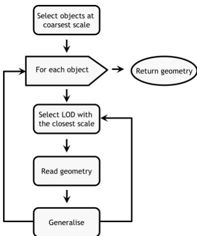
The architectural model for spatial middleware services takes the novel approach of locating spatial data on hand-held mobile devices and performing all spatial operations locally. However, spatial operations are computationally complex due to the volume of coordinate-based spatial data that they operate on. This challenge is addressed by a set of algorithms designed to reduce the complexity of spatial data, thereby reducing the processing time, memory and power consumed while manipulating it on mobile devices. These algorithms include a multi-scale, spatial data structure designed to approximate continuous scale adaptation with stepped levels of detail [98]. Access to this data structure is facilitated by a hierarchical spatial index, that uses minimum bounding boxes to approximate more complex spatial objects [188]. The levels of detail are derived using algorithms that eliminate objects based on rendered size at particular scales and simplify geometry using shape and location preserving 2D generalisation algorithms that remove vertices's by analysing directional trends against a tolerance factor [208, 181, 77]. These generalisation algorithms are model-oriented (that is, generalisation happens the spatial data model level, as opposed to at the graphic representation level [53, 131]).
to convert from longitude and latitude coordinates to a mobile devices screen coor-dinate system, are chosen to optimise the performance of coorcoor-dinate transformation at the cost of acceptable area and shape distortion [48]. Limited processing resources are preserved by clipping geometry that extends beyond the viewport of the device, to avoid computing projections and rendering coordinates that will not be seen. The novel architectural model proposed in this thesis combines and integrates these algo-rithms into a spatial middleware service capable of selecting, retrieving and rendering spatial data on hand-held mobile devices.
1.3.3 Spatial Services
Mobile, spatially-aware applications require a number of spatial services. These ser-vices include: 1) Routing; 2) Cartographic Rendering; and 3) Spatial Reasoning. The architectural model for spatial middleware services proposed by this thesis contains algorithms that provide support for each of these services.
Routing assists spatially-aware applications in generating routes between locations. To achieve this, applications require an understanding of the topological6 structure
of the user's environment. Topological representations of regions are a graph-based alternative to metric maps (also called Euclidean maps) where nodes are features and edges are paths between them. Spatial information uses an absolute coordinate system and numerical measures of positions and dimensions of objects to describe features of the environment. Representing and generating routes based on metric maps is memory and processor intensive. However, they are fast to build, easy to update, and translate well to graphical representations making them suitable for use on mobile devices. This thesis proposes an architectural model where topological relationships between objects are determined from spatial data describing the user's environment as needed.
Cartographic rendering supports mobile applications in communicating spatial in-formation to the user through their interface. In the case of location-aware applica-tions, locations must be communicated to the user along with any context that may impact the user. A cartographic (map-based) interface is a method of communicating context to mobile users that is commonly found in mobile location-aware applications
[129, 93, 50]. Location-aware applications lend themselves to a cartographic style of explanation, in which relationships between locations are depicted diagrammatically in terms of relative proximity. The architectural model proposed by this thesis contains an algorithm that produces cartographic interfaces at varying scales and resolutions, on top of which contextual information can be rendered (drawn to the screen).
Spatial reasoning is the determination of metric, topological and logical relation-ships between locations. Mobile applications rely on spatial decision support to locate nearby services, deliver directions or estimate journey times. Spatial data can be used by spatially-aware applications as a common frame of reference to facilitate better collaboration between peer devices. As an example, imagine mobile users who are equipped with a camera that is used to determine location (I can see that I am in front of the gate). With the ability to access and reason over spatial data it may be possible in the future for users who are in sight of each other to collaborate to help determine each other's positions (I can see that the door is behind you). From this example it is seen that being able to x a position in some coordinate system is not as useful as being able to determine if two entities are in view of each other [23]. An understanding of physical relationships between physical entities, for example walls block users' visibility, will be necessary in future location-aware applications [36].
Mobile Spatially-aware Applications
Middleware
Context Spatial Information
• Measurement • Analysis
• Proximity Search • Cartographic Rendering • Map Manipulation • Coordinate Conversion • Routing
• Visibility Determination
Figure 1.5: Middleware model for spatial services
algorithms for each of the GIS operations for manipulating spatial data presented in Section 1.1.3.
1.3.4 Visibility
The ability to determine if two entities are in view of each other is an example of an innovative spatial service that is supported by the architectural model described in this thesis. This service requires knowledge about features in the real world to compute whether an object is something that the user can see. This knowledge can be used in navigation applications to present instructions based on features that are visible in the real world. This is only possible with access to the vector-based spatial information that is constantly available and of reduced complexity [23].
View Frustum View Frustum
Culling
Occlusion Culling
Visible Not Visible
Figure 1.6: Illustration of visibility culling techniques
answer to the problem.
1.3.5 Genericity
The model for spatial middleware, including the set of algorithms and spatial services, provides a design whose implementation supports developers by providing generic structure and behaviour that addresses the common challenges in mobile spatially-aware applications. The model is generic, as it provides spatial services that are not conned to a single application domain but may be reused by developers of a range of mobile applications. For example: eld work applications, tour guides, navigation assistants, time management applications, messaging applications and conference aids (Section 1.1.3). Resuse of the model is also directly supported by a reusable implemen-tation that provides reusable and extensible mechanisms for spatial data management and spatial operations that execute on a mobile device. Extensibility in the model is supported by the pluggable component model that denes specic extension points where alternative algorithms may be substituted. The substitution of component im-plementations is facilitated using a conguration le that species the component in use and its parameters.
1.4 Contribution
The main contributions of the thesis can be summarised as follows:
C-1 (Addressing RQ-1)
A model for mobile spatial middleware that combines a vector-based spatial model with the ad-hoc collaboration features of the Hermes framework for mobile computing to autonomously disseminate spatial data to mobile devices.
C-2 (Addressing RQ-2)
C-3 (Addressing RQ-3)
A set of algorithms for manipulating spatial data to support services such as: route generation; rendering of personalised, adaptable map-based interfaces; and spatial reasoning. This set of algorithms preserve limited processing resources, satisfying users' expectations, by selecting data at an appropriate scale, clipping geometry to viewport extents, buering static objects and caching coordinate transformations.
C-4 (Addressing RQ-3)
The design of an innovative visibility determination service for spatially-aware applications based on the use of a depth buer on which a variation of occlusion culling is performed to reduce the set of geometry to a possibly visible set (PVS).
C-5 (Addressing RQ-4)
A comparison between the model for mobile spatial services presented in this thesis and existing approaches investigates the energy trade-o when rendering and interacting with map-based interfaces to spatially-aware mobile applications.
C-6 (Addressing RQ-5)
A generic framework for spatial services designed not to overburden the limited resources of hand-held mobile devices and does not depend on continuous network connectivity.
1.5 Thesis Outline
Chapter 2
Related Work
This chapter assesses research related to mobile spatial services. The extent to which each of the related projects addresses the research questions, identied in Section 1.2, is discussed. A review of related work in the following areas is provided (Figure 2.1):
1. Spatial services for mobile computing.
2. Map-based mobile services.
3. Commercial GIS & web mapping.
The systems presented in this chapter are representative of a wider range of systems, chosen based on their unique features or their inuence in the development of the eld.
1.Spatial Services for Mobile Computing Mobile
Spatially-Aware Applications
2.Map-Based Mobile Services
3 (a)
Commercial GIS
3 (b)Web Mapping
2.1 Spatial Services for Mobile Computing
The projects included in this section on spatial services for mobile computing are those that provide application frameworks, middleware or infrastructural support to the development of spatially-aware mobile applications.
Mobile spatially-aware applications incorporate features or services that require knowledge about the logical and topological structure of the user's environment. These applications run on hand-held mobile devices and typically make use of a positioning system to identify their location in the real world [157, 31]. Several research projects have produced mobile spatially-aware applications: comMotion [136], GeoNotes [68], Riot! 1831 [192], for example, are based on the common idea of attaching digital information to real-world places like a virtual post-it note or grati. Other projects have focused on mobile tourist guides as an application domain (for example, Guide [43], REAL [19], TellMaris [120]). Mobile games (for example, Can You See Me Now? [26]) have also enabled the exploration of the mobile use of spatial information. These applications are classed as spatially-aware as they provide some spatial services to their users. The range of services includes: navigation [43, 19, 120], map-based interfaces [43, 19, 68, 26] and location specic information services [120, 26, 192, 136]. These application services are supported by computation incorporating spatial operations such as containment, proximity, coordinate conversion, map rendering, spatial selection and route generation.
ac-Figure 2.2: The Cyberguide MessagePad interface (Source: Abowd et al. [2])
cording to several criteria based on the research questions dened in Section 1.2:
1. Availability; The availability of spatial services, despite the unreliability of wire-less networks (RQ-1).
2. Limitations of Mobile Devices; Design features, algorithms or architectural com-ponents that specically deal with managing or adapting to the limitations of mobile devices (RQ-2).
3. Spatial Operations; The set of spatial operations and services provided and the signicance of their location within the architecture (RQ-3) .
4. Genericity; The generality, reusability and extensibility of the system (RQ-4).
2.1.1 Cyberguide
[image:41.595.192.466.77.284.2]The Cyberguide system has a number of components, namely: Cartographer, a map component that handles map representation on the mobile devices; Librarian, responsible for delivering information on places of interest to the tourist; Navigator, responsible for locating the tourist's physical position indoors or outdoors; and Mes-senger, allows the user's position to be transmitted to a central service that could then help tourists nd each other or facilitate the broadcasting of messages to all users at a certain place.
The above components were designed to run on hand-held mobile devices, although the communications component required network access to a messaging server. The information component stores all information on the mobile devices (including maps), making it dicult to propagate changes in information as each device must be indi-vidually updated.
Availability
As Cyberguide's librarian component stores all information on the device, a wireless network connection is not required. Storing all the information on the device allows constant availability of applications at the cost of making information dicult to up-date. Although Cyberguide stores all information on the device, a requirement for future mobile applications to access storage resources through substantial communi-cation and networking resources was identied [129]. To investigate this possibility, a serial IR network, similar to that used by REAL [19], was built. This inexpensive network was used to communicate events and support messaging but not to access application specic information or spatial information. The inability to access spatial information means that changes (for example, the change of label in a map) still need to be manually copied to each device.
Limitations of Mobile Devices
not possible because of their computational complexity and the limited computation resources of the Cyberguide hardware.
Spatial Operations
Cyberguide has a raster map-based interface that automatically scrolls based on the user's position (Figure 2.2). Information is overlaid on this interface in the form of map markers. Despite the project name, Cyberguide involves little guidance, navigation support, or route generation. This is largely due to Cyberguide not maintaining a model of the real world, limiting its ability to generate paths or highlight objects. Cyberguide is also limited to a small geographic area and requires recompilation to operate in a new location.
The Cyberguide project also experimented with a vector-based map representation. This feature was found to support manipulation and additional services such as way-nding, but was not used because the computation required to generate a display was greater than that available in the hardware deployed (Apple MessagePad 100). Vector data was also dicult to obtain and the size of the vector-based map database prohibited local storage on hand-held devices [2].
In contrast, the bitmap representation was found to be easy to obtain (scanning) and relatively inexpensive to store and display. However, scaling and rotation are computationally expensive using a bitmap representation. In addition, the bitmap representation lacked accuracy with respect to the real-world and was not suited to providing higher level map services, such as, generating a path to direct the tourist to a location of interest [2].
Genericity
Cyberguide is designed as a system whose conceptual design rather than implementa-tion would be reused by developers. The utility of Cyberguide's architectural decompo-sition stems from the extensible and modular approach taken to system development. It is extensible as further services can be added and modular because it allows one component to be changed without impacting the rest of the system.
Figure 2.3: Deep Map interface (Source: Kray [120])
Subsequent mobile, spatially-aware applications (notably GUIDE [43]), including those that are developed using the model and algorithms for spatial middleware services de-scribed in this thesis, are built on the concepts introduced in the Cyberguide system.
2.1.2 Deep Map
In the Deep Map project, an interdisciplinary research group at the European Media Lab developed a prototype of a digital personal mobile tourist guide for the city of Heidelberg, Germany [134, 120]. The goal of the project was to develop information technologies that can handle heterogeneous data collections and complex functionality but are still accessible to untrained users. Unlike Cyberguide, where all information is stored locally on the device, Deep Map takes a two tier, client/server approach with a commercial GIS acting as the server platform. An ArcView GIS server platform hosts a number of Java GIS-agents. Mobile clients communicate with these agents using an XML-based messaging system. Two clients exist for the Deep Map system, one is a web-based planning and exploring tool for virtual visits or pre-trip planning and the other is a mobile guide designed for a wearable computer (Figure 2.3).
Availability
project raises a number of interesting research questions. In particular, Zipf (Adap-tive context-aware mobility support for tourists, an essay included in [218]) recognises the need to reduce dependency on network availability and concludes that we must develop lightweight versions of these [GIS] components in order to maintain a dynamic model of the users environment on mobile devices.
Limitations of Mobile Devices
The mobile Deep Map prototype is developed for a wearable computer (Xybernaut MA IV) with a hand-held color LCD display and a headset1. Deep Map deals with
the processing limitations of mobile devices by o-loading complex spatial operations to a server. The server responds with raster map data. This approach trades the cost of energy usage and application responsiveness on the mobile device with communica-tion costs, and assumes a reliable, always available wireless network conneccommunica-tion. The performance or energy usage of this approach was not quantied.
Spatial Operations
Spatial operations in Deep Map are handled by GIS-agents implemented using Java wrappers that communicate with the ArcView GIS via remote procedure call. One of these agents, the geo-spatial agent, retrieves spatial information from the GIS and performs a range of spatial operations [134]. Other agents are responsible for map rendering navigation and route nding. However, these spatial operations are all per-formed on server-side components of the Deep Map framework requiring continuous network connectivity with mobile clients.
Genericity
The Deep Map applications are limited to an area around Heidelberg castle where tourist information, mapping and wireless network coverage is available. Although the applications cannot be directly reused, Deep Map itself is considered a framework. The goals of the framework are to demonstrate that standard GIS functionality can implement personalisation and context awareness through adaptive map generation
Figure 2.4: The CRUMPET welcome page (Source: [206] Figure 4.)
and personalised tour proposals. Although Deep Map demonstrated that GIS func-tionality has a place in personal mobile tourist guides, the research framework they propose is not generic or reusable, in that it is only designed as a testbed for pro-totyping applications in a controlled environment. Deep Map does not support the building of spatially-aware applications for deployment in the real world [134]. Several follow-on projects continued the investigation into mobile information delivery systems for tourists. One of these is CRUMPET.
2.1.3 CRUMPET
Availability
CRUMPET is an infrastructure platform and requires reliable wireless connection to deliver spatial services to mobile devices. The periodic disconnections that arise are accounted for through the provision of a location-aware service broker agent. This agent can deliver appropriate services to the mobile device based on its location. In the case of a disconnection due to mobility, this agent may be used by the mobile device to discover services at its new location. Mobile devices do not maintain a model of the users' environment and rely entirely on a reliable wireless network infrastructure to access the CRUMPET infrastructure.
Limitations of Mobile Devices
CRUMPET targets lightweight terminals such as next-generation mobile phones and PDAs, but to date, all eld trials have been conducted using iPAQ hand-held com-puters. One of the goals of CRUMPET is to provide a service delivery platform that can adapt to the limitations of various wireless networks such as High Speed Circuit Switched Data (HSCSD), General Packet Radio Service (GPRS) or Universal Mobile Telecommunications System (UMTS). The CRUMPET platform includes functional-ity to monitor the qualfunctional-ity of service of data transmission, control data transmission formats and select appropriate protocols. CRUMPET takes the computational limi-tations of mobile devices into account through its choice of a client/server approach, which requires a reliable network connection to maintain the user experience. Net-work communication consumes energy, a limited resource on mobile device. However, CRUMPET does not factor energy consumption on the mobile device into decisions regarding network interface, data transmission formats or protocols.
Spatial Operations
The design approach is to make use of distributed geodata servers and corresponding web map servers for spatial information within the CRUMPET platform. However, applications developed for CRUMPET could not be considered spatially-aware as they do not consume vector-based spatial data but rely on the spatial agent to perform spatial functions such as spatial queries and selections, distance measures, exports of geometry data and visibility analysis. This means the CRUMPET applications do not include the spatial operations and algorithms necessary to maintain a model of the user's environment and can not provide access to common spatial services without the assistance of CRUMPET's web map servers.
The CRUMPET project recognised geographical information as being a crucial feature of tourism applications. CRUMPET concluded from its user trials that Maps rank very high, and even higher when they indicate the current position of the user. The rendering of maps, enhanced by context-sensitive information, is probably a core feature for mobile tourism support [206]. The same eld trials also uncovered a requirement that maps on mobile devices should adapt to the user's orientation and include information such as building outlines, accessibility and bus stops. Although these ndings were to inuence the design of other mobile spatially-aware applications including the spatial services presented in this thesis, CRUMPET's implementation is server-centric and does not take into account the combined challenges of mobility, resource limitations and unreliable wireless networks.
Genericity
CRUMPET supports the development of spatially-aware mobile applications by basing its architecture on a standards-compliant open source agent framework. In addition, a standards-based approach to spatial services is taken and an implementation of the platform is available as open source code.
One of the outcomes of the CRUMPET project that has been highly inuential on this thesis is the argument by Zipf [246] that spatial services need to run on mobile de-vices to reduce dependency on network availability. The model for spatial middleware presented in this thesis locates all spatial information locally on the mobile device. This design decision requires that the algorithms for manipulating the spatial information, the spatial operations for inferring relationships between objects in the environment and the spatial services such as route generation and map rendering, must also run on mobile devices. These challenges form the core areas of investigation in this thesis.
2.1.4 Nexus
Nexus is an infrastructure-based GIS platform for mobile spatial services developed by the University of Stuttgart [161, 163, 81, 165, 82]. The main focus is on modeling heterogeneous spatial information for a wide range of applications and oering an open platform on which other service providers can build their location services.
The Nexus platform species basic services, open protocols and open data exchange formats needed for location-based services. The central feature of the platform is its model of the real world called the Augmented World Model (AWM). Nexus is a three tiered architecture (Figure 2.5). Applications run on a mobile (but not necessarily hand-held) client and communicate wirelessly with the Nexus infrastructure [164].
Availability
Mobile, spatially-aware applications built for the Nexus platform (for example, NexusS-cout [162], CityNav [82], Virtual Information Towers [229]) rely on reliable wireless network connectivity between mobile devices and the infrastructure. Should this con-nection be interrupted, the application will no longer have access to any spatial data, spatial services or location-based events.
Limitations of Mobile Devices
G e o C a st E v e n t S e rv ic e A re a S e rv ic e R e g is te r DB GIS
Spatial Model Server Location Server External Data (www) S e rv ic e L a y e r
NEXUS Nodes
F e d e ra ti o n L a y e r A p p li c a ti o n L a y e r
Client A Client B
Applications
Standardised Interface • Data Integration
• Map Service • Navigation Service
Wireless Communication
Figure 2.5: The Nexus architecture (Redrawn from [82], Figure 1)
spatially-aware applications on hand-held mobile devices due to the overhead of parsing the AWM modeling language into an object-oriented data structure. Like Deep Map, Nexus provides server-side implementations of common spatial services (for example, map creation, navigation) allowing these tasks to be ooaded from resource limited mobile devices.
Spatial Operations
The Nexus application layer provides tools for constructing queries for spatial data in AWQL (Augmented World Query Language) and tools for parsing the resulting spatial data back into instances of AWM objects. However, there is no client-side support for inference or deriving spatial services from this object-oriented data structure. The Fed-eration Layer (Figure 2.5) provides support for spatial opFed-erations, including position, range, and nearest neighbour queries. In addition, a data integration service (from multiple Spatial Model Servers), a navigation service and a map service are provided.
Genericity
Overview Map
Detail Map Region of Interest
POI Information Menu
Figure 2.6: Lol@ map interface (Source: Umlauft et al. [223])
and a data exchange format called AWML (Augmented World Modeling Language) to serialise the objects of the AWM. In addition the Nexus project has published papers detailing a step-wise process of building spatially-aware applications using the Nexus Augmented World Model [165]. However, to date there has been no deployment of Nexus infrastructure.
2.1.5 Lol@
The Lol@2 system is a mobile tourist guide for the city of Vienna, developed at the
Forschungszentrum Telekommunikation Wien [89, 179, 223]. The tourist guide is a location-based mobile application designed for mobile phones that oers maps, locali-sation, routing functionality, and speech input.
LoL@ takes a similar architectural approach to CRUMPET. The main interaction metaphor is that of a browser, where a user clicks links or buttons to access information. LoL@ uses an Internet application architecture based on the client/server paradigm. A `terminal' with permanent network connection accesses a remote server where most processing takes place. The client is responsible for the display and direct interaction handling on the mobile device through a web browser (Figure 2.6).
Availability
Although LoL@ takes a predominantly client/server architectural approach, it is de-signed taking technical constraints such as limited bandwidth and possible loss of network connection into consideration. LoL@ stores all content in a database on the server. However, unlike most client/server architectures, LoL@ moves some of the ap-plication's logic to the mobile client. Simple interactions like a button press, which do not cause an information update from the server, can therefore be handled directly within the device. This concept improves response time and reduces network load. Al-though LoL@ is capable of providing a better user experience than other client/server systems in a unreliable wireless network, LoL@ does not move enough functionality to the mobile devices to allow it support highly interactive mobile applications. Due to the dynamic nature of the
![Figure 2.2: The Cyberguide MessagePad interface (Source: Abowd et al. [2])](https://thumb-us.123doks.com/thumbv2/123dok_us/885201.601077/41.595.192.466.77.284/figure-cyberguide-messagepad-interface-source-abowd-et-al.webp)
![Figure 2.3: Deep Map interface (Source: Kray [120])](https://thumb-us.123doks.com/thumbv2/123dok_us/885201.601077/44.595.244.397.77.290/figure-deep-map-interface-source-kray.webp)