Jennifer A. Sizemore. Evaluating Library Instruction in GIS: GIS Boot Camp for Planners. A Master’s Paper for the M.S. in L.S degree. May, 2010. 48 pages. Advisor: Jeffrey Pomerantz
This study describes a survey designed to evaluate instruction in Geographic Information Systems (GIS) in order to determine whether librarian-led GIS instruction will facilitate the application of GIS to related coursework. The respondents were graduate students who participated in a three-day intensive instruction program given at the University of North Carolina at Chapel Hill called GIS Boot Camp for Planners. The results of the survey show that the GIS instruction sessions were found to be useful in related
coursework and increased the students’ comfort level with GIS software. The students’ perceptions of their knowledge acquisition show increased levels of confidence for all the major learning objectives of the program. Suggestions are made for the improvement of this program and those similar to it at other institutions.
Headings:
Geographic information systems
College and university libraries – Reference services
Library service – Evaluation
EVALUATING LIBRARY INSTRUCTION IN GIS: GIS BOOT CAMP FOR PLANNERS
by
Jennifer A. Sizemore
A Master’s paper submitted to the faculty of the School of Information and Library Science of the University of North Carolina at Chapel Hill
in partial fulfillment of the requirements for the degree of Master of Science in
Library Science.
Chapel Hill, North Carolina
April 2010
Approved by
Table of Contents
Introduction……….2
Literature Review………4
Institutional Context………8
Methodology………..…10
Results………13
Discussion………..30
Bibliography………...33
Introduction
Evaluation of library instruction is a difficult, though important, task. Librarians
are held accountable for providing services that meet the needs of their users. It would be
easy to rely on anecdotal evidence that students appreciate and learn from the services
librarians provide. However, analysis of outcomes done in a systematic manner are a
more reliable and valid evaluation of library services. The cost of these services must be
justified by demonstrable and positive outcomes for users. Instruction in academic
libraries is a service for which these outcomes are especially important. Are students
learning from instruction sessions and are they acquiring and retaining skills that will
help them do better research? Assessing knowledge acquisition is a tricky proposition;
several methods have been used to evaluate learning outcomes.
Instruction in spatial research and Geographic Information Systems (GIS) is a
narrow subfield of library instruction. Indeed, spatial research as a discipline is only
several decades old. Spatial research involves collecting, analyzing, and displaying
geospatial data in order to answer questions about the intersection of any type of data and
their location in space. One example of such a question is to see if there is any geographic
pattern to the instances of a particular disease. Spatial analysis is generally accomplished
using mapping software called Geographic Information Systems (GIS). Most academic
libraries are now offering support for spatial research, including instruction sessions. GIS
is used in many disciplines, including geography, urban planning, business, and public
courses, but many do not teach their students how to use the complicated software that
goes along with it. Software is constantly changing, and so professors concentrate on
conveying theoretical knowledge instead (Montagu, 2001). This leaves many students
frustrated by learning very complex software on their own.
Increasingly, GIS librarians are helping to fill this gap with GIS instruction
sessions. Currently little research has been done to evaluate whether these instruction
sessions are accomplishing their objectives. The research described here attempts to
discover whether librarian-led instruction in spatial analysis theories and software
facilitates the application of GIS to related coursework in graduate and undergraduate
students. We have measured this by assessing students’ self-reported knowledge
acquisition and comfort level using GIS software after the instruction session.
The research study is based on the results of a survey given to graduate students
in the Department of City & Regional Planning at the University of North Carolina at
Chapel Hill who participated in a librarian-led instruction program called GIS Boot Camp
for Planners. The goal of the survey was to discover to what extent the students felt that
the library instruction helped them in their related coursework, whether they felt that it
increased their interest in learning more about GIS, and what their perceptions of their
knowledge acquisition was in the GIS theories and skills that were presented to them.
Little if any research currently exists in the LIS literature that discusses the evaluation of
GIS instruction in libraries. The ultimate aim of this study is to help GIS librarians
Literature Review
As more and more information becomes available electronically and as mapping
software becomes more advanced and widespread, GIS has been increasingly applied to a
variety of disciplines, including geography, city planning, public health, history, and
business. GIS first began appearing in academic libraries in the 1980s, and spatial
research services expanded in the 1990s when the U.S. Census was distributed to federal
depositories in the form of TIGER (Topologically Integrated Geographic Encoding and
Referencing) files (Gabaldon and Repplinger 2008). Academic libraries have had to alter
their services to incorporate support for GIS and spatial research (Abresch et al. 2008).
Several universities have published accounts of how GIS services have been initiated in
academic libraries, including a report by Julia Todd, who discusses the evolution of GIS
services at Baker University (2008). Another article written by John A. Olson describes
the process of establishing a GIS lab at Syracuse University Library, including the
planning, administrative support, public services, and data management issues involved
(2004).
A SPEC Kit was published by the Association of Research Libraries (ARL) in
2005 that discusses a survey of GIS services available at ARL libraries (Salem 2005).
Their survey found that nearly all ARL libraries (all but one of the libraries that
responded to their survey) offer services in support of spatial research. About 71 percent
of responding libraries reported that they offer instruction sessions in GIS. These sources
confirm that GIS is a rapidly growing field, one for which librarians are expanding
services to meet new demands.
The author was unable to find any research that discusses the evaluation of GIS
relatively new field, and most librarians will agree that evaluation of instruction is a
daunting and time-consuming project. There are some research articles to be found in the
education literature that have to do with GIS instruction evaluation. One study done at
Bowling Green State University in 2005 gathered student evaluations of three
undergraduate courses that involved spatial analysis: World Regional Geography, Urban
Geography, and Introduction to GIS (Smith and Zhou 2005). The researchers distributed
surveys that asked students to assess their confidence in performing various spatial
analysis activities. This study helped instructors understand which spatial analysis
theories were understood by students and which they were still struggling with and
allowed them to compare GIS competency across the three courses. Another study
conducted at the University of Arizona discusses the integration of GIS into introductory
geography courses (Hall-Wallace and McAuliffe 2002). Their goal was to understand
whether using GIS would increase students’ ability to spatially analyze information. Pre-
and post-tests of students’ knowledge were given before and after the instruction, and
results show that scores improved by a mean of 17 percent. The researchers concluded
that this relatively low rate of improvement was due in part to the students’ difficulty
with the technical aspects of the software. However, the study did show a positive
correlation between spatial thinking and GIS-based learning.
Assessment of bibliographic instruction in libraries has been widely researched
and reported on. Although very different in some regards, bibliographic and GIS
instruction in libraries is in many ways similar: They teach students how to use
technology they may not be familiar with to do research and answer questions. They
increase information literacy skills. And both are often curriculum-based instruction
instruction relevant to this research. There is a wide array of studies that evaluate
instruction in different ways. Elizabeth Carter presents a general discussion of the need
for outcomes assessment to evaluate instruction services in academic libraries,
concluding that assessment is important because it “influences library instruction content,
staffing, collection development, and collaboration with faculty and academic
departments” (2002, 36).
Assessment methods vary greatly. Lorrie Knight reports a study in which pre- and
post-tests of library skills were given at the University of the Pacific Library before and
after library instruction (2002). Results show that freshmen at an undergraduate
university have low levels of information literacy and that library instruction does
improve research skills. Several other studies have asked students to assess their research
confidence before and after library instruction. One study done in three Canadian
academic libraries used three surveys to evaluate research confidence: a pre-test before
instruction, a post-test directly after the instruction, and a post-post-test given three to
four months after the instruction (Julien and Boon 2004). Their goal was to evaluate the
lasting impact of library instruction. Students’ scores on the tests were highest for the
post-test, and were lower for the post-post-test (though still higher than the pre-test). The
study also used interviews with students to get feedback on students’ feelings about the
instruction sessions. A similar study done at the University of Montana evaluated
curriculum-based library instruction; librarians developed a research module for an
undergraduate course on public speaking (Zoellner, Samson and Hines 2008). They used
pre- and post-tests to evaluate research confidence, and concluded that library instruction
Other research has evaluated the long-term effect of library instruction. One such
study done at the Hong Kong University of Science and Technology Library asked
students to evaluate the impact of the library instruction two months after it had occurred
(Wong, Chan, and Chu 2006). They wanted to “allow the attendees to apply the library
skills learned to their projects or assignments, hence reinforcing the skills as well as their
perception of the library session, or, on the contrary, to allow attendees to see the
weaknesses or inadequacies of the library session” (p. 386). A high percentage of
students (over 85%) surveyed felt that the instruction sessions were useful and that they
continued to use the skills they learned there over the next two months.
Another method of evaluating students’ learning outcomes is to assess differences
in the research assignments they complete for their regular coursework. Librarians at
Central Michigan University looked at the grades that students received in English
composition courses, and compared those who received library instruction to those who
did not (Wang 2006). They also viewed research papers written by students to assess the
number and variety of citations used. Students who participated in library instruction had
both higher grades and incorporated a higher number and greater variety of scholarly
resources in their research.
There are several books that consolidate these various approaches and provide
practical suggestions for librarians hoping to start an evaluation program at their library.
Matthews (2007), Durrance (2005), and Whitlatch(2000) have all written such books,
which are quite helpful in providing step-by-step guidance for evaluating library services,
including instruction. The many methods and approaches to the evaluation of
bibliographic instruction discussed in these sources can be used to assess GIS library
Institutional Context
This study evaluates a program introduced at the University of North Carolina at
Chapel Hill in the fall of 2009 called GIS Boot Camp for Planners. UNC offers a masters
degree in City and Regional Planning, and most of these students use GIS in their
coursework. In their first semester, all students are required to take a course called Urban
Spatial Structure, for which students are required to use GIS for several assignments.
Most students have little or no background in GIS. In the spring of 2009, current
Planning students approached the Planning and GIS Librarians with the suggestion of an
instruction session to help introduce incoming students to GIS software in order to better
prepare them for Urban Spatial Structure. They had done an informal survey of their
classmates and found that most students were overwhelmed by the GIS requirement in
their first semester, many struggling to learn the software adequately to complete their
assignments. The survey clearly indicated a need for additional instruction in GIS. Based
on this information, the librarians decided to institute an intensive GIS instruction session
for the students, and called it GIS Boot Camp for Planners. An intensive model was
needed in order to get the students ready to use the complex GIS software in a short
amount of time so that they could use those skills in the first semester of their curriculum.
GIS Boot Camp for Planners consisted of three 3-hour sessions given on
consecutive Fridays at the beginning of the fall semester. Nearly all the students (about
thirty-five) registered for Urban Spatial Structure participated. The sessions consisted of
short lectures on spatial analysis theories followed by hands-on exercises in GIS
software. Day one included a basic introduction to GIS, including data models,
entirely to the often confusing topic of coordinate systems and how to work with them.
And day three’s topics included finding, organizing, and manipulating spatial data. The
sessions were conducted in a computer lab so that all the students were able to do the
exercises.
The instruction sessions were designed to convey both spatial analysis theories as
well as instruction in using GIS software. Spatial analysis theories include “collecting,
integrating, analyzing, displaying, and communicating spatial information and data
sources using mapping and geographic information systems (GIS)” (Smith and Zhou,
211). The GIS software used for the session was ArcGIS 9.3, including ArcCatalog and
ArcMap. The librarians decided on the following learning objectives for the sessions:
Spatial Analysis Learning Objectives
• Understand what GIS is
• Recognize and distinguish between the two types of data models: vector and
raster
• Understand a relational database
• Understand map projections and coordinate systems
GIS Software Learning Objectives
• Find and load spatial data into ArcMap
• View and manipulate metadata in ArcCatalog
• Join tabular data to spatial data
Methodology
In order to evaluate the effectiveness of GIS Boot Camp for Planners, the
participating students were asked to complete a survey assessing their perceptions of the
usefulness of the session to their coursework, as well as their perceptions of their
knowledge acquisition and their degree of comfort using GIS software compared with
before the instruction session. The surveys were administered online, and invitations to
participate were distributed via email. Two reminder emails were sent out to elicit more
responses. The survey was administered four months after GIS Boot Camp for Planners,
about a month after the students completed the course (Urban Spatial Structure) for
which the instruction sessions were designed. This timing allowed students to better
evaluate the extent to which they actually used what they learned in GIS Boot Camp in
their related coursework. Students were encouraged to answer as honestly as possible, in
order to improve the instruction session for future students. The survey was administered
by a graduate student in library science who was not involved in the planning or
implementation of GIS Boot Camp for Planners.
The survey began with a short description of GIS Boot Camp for Planners.
Because the survey was administered four months after GIS Boot Camp, it was decided
that some students may have trouble recalling precisely what the instruction sessions
consisted of. This description served to remind them of the structure and topics covered
in the program. The first couple of questions were introductory in nature, including
asking whether students had participated in GIS Boot Camp for Planners and asking their
academic status.
The main portion of the survey had three sections. The first section included
Camp for Planners to their related coursework, in this case Urban Spatial Structure.
The second section asked students to rate their ability to complete several spatial analysis
tasks before and after GIS Boot Camp for Planners; these questions strived to measure
the students’ knowledge acquisition of spatial analysis concepts and software tasks. And
the final section consisted of several open-ended questions that asked about various other
aspects of the instruction sessions and allowed the students to give any additional
comments they had. The complete survey is reproduced in Appendix A.
Part 1: Usefulness of Instruction in Coursework
The students’ perceptions of the usefulness of GIS to their related coursework was
assessed by asking a few Likert scale questions (using strongly agree, agree, neither agree
nor disagree, disagree, strongly disagree). These questions were designed to elicit
information about whether the students used what they learned in GIS Boot Camp in their
class, whether they felt that the instruction session adequately prepared them for their
GIS assignments, and to what degree Boot Camp increased their comfort level with GIS.
We also included a question on whether the students had used what they learned in Boot
Camp in any of their other courses at UNC, in order to determine whether the students
were using GIS in additional classes.
Part 2: Self-reported Knowledge Questions
Students were asked to rate their ability to complete several spatial analysis tasks,
with 0 being they cannot even start the task and 5 being that they could do it with the
proficiency of a GIS professional. Further guidance for this scale was given in an effort to
0 -- Unable to start the task
1 -- Know where to look for help, but otherwise unable to start the task
2 -- Able to complete the task with a step-by-step handout and personal assistance
3 -- Able to complete the task with novice proficiency
4 -- Able to complete the task with intermediate proficiency
5 -- Able to complete the task with the proficiency of a GIS professional
The students were asked to make an evaluation of their knowledge/skill level for
each task before and after GIS Boot Camp. Each task was described in concrete terms so
that the students would not have any trouble determining what skill the question was
asking about. Five tasks were included, each of which was closely associated with one of
the major learning objectives of the instruction sessions.
Part 3: Additional Open-Ended Questions
The final section of the survey consisted of open-ended questions that allowed the
students to make any additional comments they desired. The questions asked about the
timing of the sessions, the depth and amount of content covered in the sessions, and what
topics they would have liked to learn more about.
The three sections of the survey were designed to determine the degree to which
GIS Boot Camp for Planners efficiently accomplished its stated learning objectives. The
GIS and Planning Librarians were involved with the planning of the survey, which helped
ensure that the survey included questions related to all the important aspects of the
sessions.
The instrument did go through a pretesting process. The librarians who taught
used during the sessions so that the students would not be confused by the wording of
any of the questions. They also ensured that all of knowledge acquisition questions were
directly linked to one of the main learning objectives of the program. The survey was
administered to two graduate students who did not participate in GIS Boot Camp for
Planners but who were familiar with GIS. Their feedback was helpful in determining
whether the questions were clear, and to test how long the survey would take participants.
Results
The online survey was sent to the thirty-four Masters students in City & Regional
Planning who participated in GIS Boot Camp for Planners in the fall of 2009. From the
initial contact, combined with two reminder invitations, fifteen of these students
completed the survey. This 44 percent response rate is adequate to give us a good idea of
what the students overall thought of the program. All the survey responses were included
in our data, with the exception of one participant’s incomplete answers to section 2 (in
which the students were asked to rate their ability to complete tasks in GIS software).
The results show generally that students were quite satisfied with the instruction
sessions. Section 1 of the survey, consisting of Likert scale questions in which
participants agreed or disagreed with statements, shows that most participants felt that
they used what they learned in GIS Boot Camp for Planners in their related coursework.
Section 2, in which participants rated their ability to perform specific GIS tasks in the
software, shows that the students’ confidence in their ability to use GIS software was
greatly increased. This section also shows which GIS concepts students were less
instruction sessions. Section 3, consisting of open-ended questions, gives us more
information about the students’ feelings about the instruction sessions.
The results of each section will be discussed in more detail below. The complete
results are reproduced in Appendix B.
Section 1
The purpose of this section was to determine the students’ perceptions of GIS
Boot Camp for Planners, especially whether they felt that they used what they learned in
the instruction sessions in their related coursework (in this case, a City Planning course)
and whether the Boot Camp increased their comfort level using GIS software. The results
show that the respondents largely felt that Boot Camp was quite useful in their
coursework and increased their comfort level.
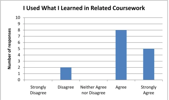
One question (figure 1) asked participants to disagree or agree to the following
statement: “I used what I learned in GIS Boot Camp for Planners in my coursework for
Urban Spatial Structure (PLAN 714).” Eighty-six percent of respondents either agreed or
strongly agreed with this statement. Two respondents (13 percent) disagreed with the
statement. This clearly shows that the GIS library instruction introduced concepts and
technical skills that were useful in related coursework. The fact that two respondents
disagreed with this statement shows that while most students found the sessions useful,
not all did. We may assume that these dissatisfied students did not feel that they learned
much about GIS in Boot Camp (since all the students were required to do at least some
GIS work in their related class, Urban Spatial Structure). It is possible that they struggled
Figure 1 – “I used what I learned in GIS Boot Camp for Planners in my coursework for Urban Spatial
Structure (PLAN 714).”
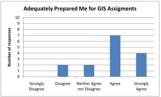
The next question of the survey was similar in nature. Participants were asked to
agree or disagree with the statement “GIS Boot Camp for Planners adequately prepared
me for the assignments involving GIS in Urban Spatial Structure (PLAN 714).” The
students in this course were required to complete several projects that involved using GIS
software (though many of the students had little, if any, previous experience using GIS).
This survey question was designed to determine whether students felt that GIS Boot
Camp was an adequate enough introduction to GIS to give them the knowledge and
technical skills they needed to complete these assignments. Responses were slightly
lower for this question, though still generally high. Seventy-four percent of respondents
agreed or strongly agreed (see figure 2). It is not surprising that the responses were
somewhat lower for this question, as the GIS assignments for Urban Spatial Structure are
rather complex and often difficult for students who are new to GIS. Any introduction to
GIS, no matter how thorough, may not be adequate for some students to become
0 1 2 3 4 5 6 7 8 9 10
Strongly
Disagree Disagree Neither Agree nor Disagree Agree Strongly Agree
N
umb
er o
f re
sp
on
se
s
proficient in GIS software. The students who disagreed may have felt that they needed
additional instruction in GIS to complete their projects.
Figure 2 -- “GIS Boot Camp for Planners adequately prepared me for the assignments involving GIS in
Urban Spatial Structure (PLAN 714).”
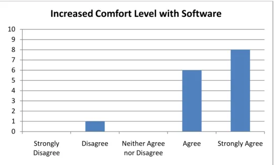
The survey also asked about the students’ comfort level using GIS software.
Participants were asked to agree or disagree with the statement “GIS Boot Camp for
Planners increased my comfort level using GIS software.” The results (figure 3) show
that most students felt that the library instruction sessions greatly increased their comfort
level. Nearly all the respondents (93 percent) either agreed or strongly agreed with the
statement, and 53 percent strongly agreed with it. Only one respondent disagreed with the
statement. This result shows that while GIS Boot Camp may not have given students all
the conceptual knowledge and technical skills they needed to complete advanced GIS
projects, the library instruction sessions certainly gave students some comfort level using
the complicated software.
0 1 2 3 4 5 6 7 8 9 10
Strongly
Disagree Disagree Neither Agree nor Disagree Agree Strongly Agree
N
umb
er o
f re
sp
on
se
s
Figure 3 -- “GIS Boot Camp for Planners increased my comfort level using GIS software.”
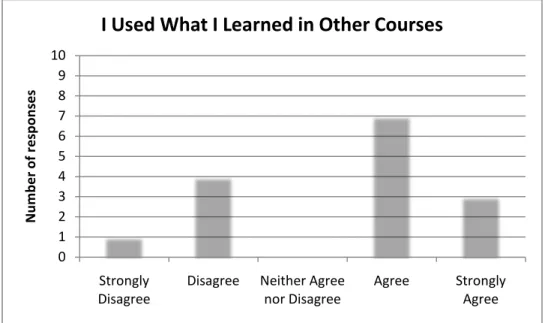
The survey also elicited information on whether the students had used what they
learned in GIS Boot Camp for Planners in other coursework, beyond the course (PLAN
714) for which the instruction sessions were designed. The results were mixed for this
question, a relatively high number of respondents (67 percent) who agreed or strongly
agreed with the statement and a sizeable chunk (34 percent) who disagreed or strongly
disagreed (see figure 4). We do not know from this survey whether the students who
disagreed with the statement (and have not used what they learned in additional courses)
did so because they haven’t taken any other courses for which GIS was used or whether
they’ve taken courses that use GIS but that the skills they learned in Boot Camp were not
applicable. It is reasonable to assume the former, i.e. that these students have not taken
any more courses with a GIS component in them. The introductory nature of Boot Camp
means that the basic concepts covered would have been applicable to any GIS work the
students did for later classes.
0 1 2 3 4 5 6 7 8 9 10
Strongly
Disagree Disagree Neither Agree nor Disagree Agree Strongly Agree
Figure 4 – “I have used what I learned in GIS Boot Camp for Planners in other courses at UNC.”
The results from this question fits together with what the librarians have noted
about students in the City & Regional Planning program; as some students learn about
GIS, they discover that they really enjoy it and get interested in learning more. Other
students do not enjoy the GIS work that they do early in their Masters curriculum and shy
away from it in the future. It would be interesting to do future research that looks at
whether GIS Boot Camp for Planners increases the number of students who pursue GIS
while doing their coursework for their Masters degree. It is possible that the introduction
they have to GIS through the Boot Camp helps students feel more comfortable with the
software, and therefore more willing to pursue further GIS study later.
This interest in learning more about GIS constitutes the final question of Section 1
of the survey. Respondents were asked to agree or disagree with the statement “GIS Boot
Camp for Planners increased my level of interest in learning more about GIS.” A high
percentage (87 percent) agreed or strongly agreed with the statement, while 14 percent
disagreed. This question shows a satisfying number of students who felt that the library
GIS instruction was interesting enough to pique their interest in learning more.
0 1 2 3 4 5 6 7 8 9 10 Strongly
Disagree Disagree Neither Agree nor Disagree Agree Strongly Agree
N umb er o f re sp on se s
Overall, the results of Section 1 of the survey show that the students’
perceptions of the usefulness of GIS Boot Camp were quite high. The participants also
felt the instruction sessions were helpful to them in their related coursework, increased
their comfort level with GIS software, and encouraged them to pursue further GIS study.
Section 2
Section 2 of the survey was designed to produce information on the students’
perceptions of their knowledge acquisition of GIS theories and technical skills during
GIS Boot Camp for Planners. Participants were asked to rate their ability to perform
specific tasks within GIS software. These tasks are some of the most basic and integral
activities involved with spatial analysis using GIS software, and each of them was closely
related to one of the main learning objectives set by the librarians who created GIS Boot
Camp. Participants were asked to rate their ability (on a scale from 0 to 5) both before
GIS Boot Camp and after the sessions. Guidelines for the scale were provided, with 0
being that the participant would not even be able to start the task and 5 being that the
participant could complete the task with the proficiency of a GIS professional.
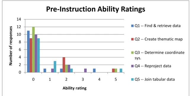
The scores with which students rated their ability to complete the tasks before
GIS Boot Camp confirm what was expected about the students’ prior knowledge of GIS:
the scores were quite low, with the majority of the students (ranging between 60 and 80
percent depending on the task) rating their ability as 0 before Boot Camp (see figure 5).
Most City & Regional Planning students come into the program with little or no
experience using GIS. This fact was one of the reasons GIS Boot Camp for Planners was
instituted; it was felt that an intensive introduction was needed to get students ready to
Figure 5 – Pre-Instruction Ability Ratings
Figure 6 shows the post-instruction scores for each task. As can be seen, the
scores the participants assigned to their ability to complete the tasks after Boot Camp
were consistently much higher than before the instruction sessions, with most students
rating their ability between 2 and 5 for each of the tasks.
Figure 6 – Post-Instruction Ability Ratings
0 2 4 6 8 10 12 14
0 1 2 3 4 5
N umb er o f re sp on se s Ability rating
Pre-Instruction Ability Ratings
Q1 -- Find & retrieve data
Q2 -- Create thematic map
Q3 -- Determine coordinate sys.
Q4 -- Reproject data
Q5 -- Join tabular data
0 1 2 3 4 5 6 7
0 1 2 3 4 5
N umb er o f re sp on se s Ability rating
Post-Instruction Ability Ratings
Q1 -- Find & retrieve data Q2 -- Create thematic map Q3 -- Determine coordinate sys. Q4 -- Reproject data
The data from section 2 also provides useful information about which GIS
activities the students had the most knowledge of coming into the sessions, as well as
what activities the students felt less confident about after the sessions. For example,
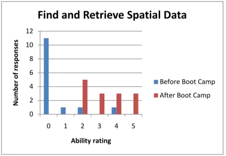
finding and retrieving data is one of the most integral (and often most difficult) aspects of
spatial analysis; spatial analysis in GIS software cannot begin until you have identified
pertinent data and loaded it into the software. The students’ ability ratings before the
session were among the lowest for all the tasks, with only three students rating
themselves higher than a 0. The scores they rated themselves after the sessions ranged
between 2 and 5, one of the stronger of the post-instruction ratings (see figure 7). This
large jump between low pre-instruction scores and high post-instruction scores shows
that this section of the instruction session was quite effective; the students went from
knowing very little about this important concept before GIS Boot Camp to being quite
confident in this area.
Figure 7 – “Find and retrieve spatial data using the library's Datafinder.”
The two tasks with the lowest post-instruction ratings were “Use ArcCatalog to
determine the coordinate system used in a particular spatial dataset” and the related “Use
0 2 4 6 8 10 12
0 1 2 3 4 5
N
umb
er o
f re
sp
on
se
s
Ability rating
Find and Retrieve Spatial Data
ArcMap to reproject data that is in a geographic coordinate system to State Plane
Meters.” Post-instruction scores ranged from 0 to 5 for both questions, with the majority
of students rating themselves a 3 or below (see figures 8 and 9). This should not come as
a surprise to any GIS librarian. Coordinate systems are a complex theory to grasp, and
students often struggle with it. One entire day’s session of GIS Boot Camp for Planners
was devoted to coordinate systems, and still the students rated their confidence level in
this area as the lowest of all the GIS activities. However, the scores are not drastically
lower, as can be seen from figure 6. We can infer from this that while students still
struggle with the idea of coordinate systems, GIS Boot Camp did at least give them some
confidence in using coordinate systems in GIS software.
Figure 8 – “Use ArcCatalog to determine the coordinate system used in a particular spatial dataset.”
0 2 4 6 8 10 12
0 1 2 3 4 5
N
umb
er o
f re
sp
on
se
s
Ability rating
Determine the coordinate system
Figure 9 – “Use ArcMap to reproject data that is in a geographic coordinate system to State Plane Meters.”
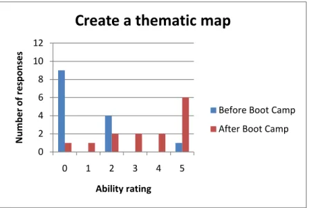
The “Create a thematic map” task received the highest post-instruction ratings;
the mode for the post-instruction rating was a 5 for this question (see figure 10). This also
is not a surprise; creating a thematic map is the most basic purpose of GIS software, and
therefore often the easiest to accomplish. However, as thematic maps are generally the
desired outcome of working with GIS software, it is important for students to understand
how to accomplish it. The students in GIS Boot Camp for Planners obviously learned a
great deal about thematic maps and how to create them.
0 2 4 6 8 10 12
0 1 2 3 4 5
N
umb
er o
f re
sp
on
se
s
Ability rating
Reproject Data
Figure 10 – “Use ArcMap to create a thematic map showing income levels in Orange County block
groups.”
The results from section 2 of the survey prove that the students’ perceptions of
their knowledge acquisition of GIS theories and technical skills during GIS Boot Camp
for Planners were satisfyingly high. The students rated their ability to use GIS software
much higher after the sessions compared with before. The results also show the areas
where students gained the least confidence and where more emphasis may need to be
placed in future GIS library instruction sessions. This information can be used to improve
GIS Boot Camp for Planners at UNC so that students are more prepared for PLAN 714,
Urban Spatial Structure, but it can also be used by librarians in other institutions who are
designing similar programs for GIS instruction.
Section 3
Section 3 of the survey consisted of four open-ended questions designed to allow
students to respond more freely about GIS Boot Camp for Planners. The first three
questions asked about specific aspects of the program: the timing and structure; the depth
and amount of content covered; and any topics that they would have liked to have been
0 2 4 6 8 10 12
0 1 2 3 4 5
N
umb
er o
f re
sp
on
se
s
Ability rating
Create a thematic map
covered that were not. The fourth question prompted them for any further comments
they had.
Nearly all the participants had comments about the timing and structure of the
program. GIS Boot Camp for Planners was given over three sessions, from 9am to 12pm
on three consecutive Fridays at the beginning of the fall semester. While some students
complained that the sessions were too early, most respondents seemed happy with the
timing. Some complained that they had to miss sessions due to previous engagements,
but most agreed that having the sessions at the beginning of the semester worked well.
Several respondents commented that the sessions were too long. One person wrote,
“Sessions were too l[o]ng to absorb information.” Another commented, “The session[s]
were very long. Too intensive. I’ll take more sessions and short[en] the time.”
The second open-ended questions asked students whether they thought the depth
of the content and the amount of information covered were appropriate. Only a couple of
the respondents commented that there was too little information covered (it is possible
that these students had some GIS knowledge coming into the sessions); all the rest of the
responses state there was enough or too much information presented during GIS Boot
Camp. Several students felt overwhelmed by the sessions: “It was very overwhelming at
first... It was just too much too fast for those of us who have never seen the software
before.” GIS software is quite complex, so it is unsurprising that students may have felt
some information overload. However, most students agreed that the amount of
information was appropriate, or at least the necessary amount for them to get a good
introduction to GIS.
There were fewer responses to the question asking students to provide topics that
respondent requested “more advanced techniques like spatial analyst, topographic
modeling, etc.” However, these topics are quite outside the scope of an introductory
session to GIS. The lack of responses can be seen as testament to the fact that all the
basics of GIS that the students needed was covered in GIS Boot Camp for Planners.
The final question elicited any further comments that the participants had about
GIS Boot Camp for Planners. One person commented that “projections and coordinate
systems [are] difficult to grasp”, confirming our results from section 2 that this concept
still presents a challenge to students. Other responses show that while students may have
been overwhelmed by the amount of information covered in the sessions, it at least gave
them some basis of knowledge and information about how to learn more: “I didn’t feel
comfortable using the software after the bootcamp, but it did provide an introduction and
encourage me to do the tutorials later, at my own pace – so in that sense it was very
helpful.”
The results from section 3 of the survey can provide some useful insights into
how the librarians may improve GIS Boot Camp for Planners in the future. It may be
useful to break the sessions down further, providing a greater number of shorter sessions.
It is also important for the librarians to remember that this sort of introduction can be
overwhelming and intimidating to students who have no prior experience with GIS.
Instructors must keep the amount of information manageable and leave plenty of time for
students to do hands-on activities that will reinforce the information they are learning. It
is also important for the instructors to provide plenty of information on how the students
can access GIS support in the future, either by contacting the librarians for one-on-one
The results of this survey prove a great deal about the success of GIS Boot
Camp for Planners. But it also allows us to make some recommendations for future
instances of GIS Boot Camp and other similar programs. Our survey highlighted a few
areas where students still struggle and which may require more emphasis in subsequent
sessions, especially working with coordinate systems. We also received some
enlightening comments about the timing and structure of the program. It may be good to
break the sessions down into a higher number of shorter sessions. This may help with the
students’ feelings of being overwhelmed by the amount of information covered.
Additionally, it may be helpful to offer extra, optional sessions for those who feel they
need it. These optional sessions could allow students who are still struggling to get extra
support, as well provide students who are very interested in GIS with more opportunities
to learn.
There were also some suggestions made about the hands-on activities given to
students during the program. One student commented, “It would have been helpful to
have more time to play around a bit. Following step by step with [the] instructor was
good, but the content didn't stick because I wasn't applying it on my own.” The exercises
done in GIS Boot Camp were designed to give the students written step-by-step
instructions on how to accomplish various tasks in the software. It may be helpful to give
the students additional exercises that are similar in nature, but do not include step-by-step
instructions. This may reinforce what the students are learning and allow them additional
practice. These recommendations could help to improve GIS Boot Camp for Planners for
Limitations of the Study
There are several limitations to be mindful of regarding this study. The first is the
timing of the survey given to students. GIS Boot Camp for Planners occurred in early
September; surveys were not distributed until four months later in early February. This
time lag is substantial, and it is probable that many students had some difficulty perfectly
remembering the instruction session. A survey given directly after the session would
better evaluate the knowledge acquisition of the students. Another problem is that many
students may have evaluated their knowledge of GIS based not only on what they learned
in GIS Boot Camp for Planners, but also what they learned throughout the semester as
they completed their assignments for which GIS analysis was expected. Future research
could be done to see if timing the survey differently changes the results significantly.
However, this time lag did serve a purpose as well. The librarians at UNC were
especially interested to see if students found the instruction session useful to them in their
actual coursework, in this case the City Planning course. By waiting to evaluate GIS Boot
Camp until the semester was over, students were able to better evaluate whether they
used what they learned in GIS Boot Camp for Planners in their coursework. The students
had completed all the GIS assignments for their course and could determine whether GIS
Boot Camp adequately prepared them for these assignments.
The second limitation is the lack of a pre-test to provide a baseline for students’
knowledge of spatial analysis and GIS before the instruction session. This problem has
hopefully been mitigated to some extent by a retrospective pretest methodology of asking
students to evaluate their perception of their knowledge before as well as after the
instruction session. Some studies have found that the retrospective pretest methodology
McGuigan, and Katzev 2000). Pratt et al.’s research shows that there can be a
“program-produced change in understanding, or response shift,” in the participants of a
program; this means that when participants’ knowledge of the subject matter is increased
through a program or instruction, they will often view their pre-instruction abilities
differently afterward. In a traditional pre-test, they may overestimate their abilities simply
because they do not know much about the subject; if you ask them their perceptions of
their pre-instruction abilities after the program, they will often give very different
responses. The students coming into GIS Boot Camp for Planners often had very little
knowledge of GIS. A traditional pretest may have been misleading, as students may have
thought they knew more than they actually did about GIS. A retrospective pre-test also
has the advantage of being easier to administer; only one test is given rather than two,
which can increase participation in the survey.
The final limitation is the fact that the survey asked students to rate their
perceptions of their knowledge of GIS, rather than asking them to actually demonstrate it.
A test that required students to demonstrate the skills learned in GIS Boot Camp for
Planners may possibly be a better indicator of their knowledge acquisition. Considering
the time lag described above, we decided that a more general approach to the students’
learning outcomes would be more useful in this instance. A survey requiring students to
actually use GIS software to complete tasks would also have taken the participants much
longer to complete and may have decreased participation in the survey. However, future
work done to assess the students’ knowledge acquisition would be helpful in determining
whether the students’ perceptions of their skills are realistic. Another opportunity for
future work may be to compare the students’ GIS-related course assignments to see if
instruction and those who do not. It would be interesting to see if students who have
received library instruction receive higher grades on their GIS assignments or do more
complex spatial analysis.
Discussion
The results of this research study show that the students who participated in GIS
Boot Camp for Planners were able to use the information they received in the library
instruction sessions in their related coursework. The relatively high degree to which they
felt that Boot Camp prepared them for their GIS research is especially important. The
goal of these instruction sessions is to facilitate the use of GIS in related coursework; the
students’ feelings about the helpfulness of the instruction session confirm that librarians
are accomplishing this goal.
The knowledge acquisition questions from section 2 show that students rated their
level of expertise in GIS as notably higher after the instruction session. The various
scores from this portion of the survey also show what GIS theories and software tasks
students understand better and worse. This information will be useful as librarians refine
the service for future sessions.
There are many opportunities for further research based on the results of this
study. We have shown that students are using what they learn in their related coursework;
however, this study does not offer any comparison between the GIS knowledge and
abilities of students who participated in GIS Boot Camp for Planners versus those who
did not. Are the students who participated in Boot Camp more proficient at GIS than their
GIS Boot Camp for Planners increase the percentage of students who pursued further
GIS study during the completion of their Masters degree?
Another consideration is to think about how other methodologies for the
evaluation of this program may change the results. For example, would a survey given
directly after the instruction sessions provide new insights into the students’ knowledge
acquisition? How would direct tests of GIS knowledge differ from our results of students’
perceptions of their abilities? A traditional pretest before the program, followed by a test
in which the students had to complete tasks in GIS software would be more concrete
proof of the participants’ knowledge acquisition.
Another opportunity for research may be to study the differing GIS instruction
needs of other populations of students. This study evaluated a program designed for City
Planning Masters students. How do the needs of students in other levels of study or
subject areas differ?
The results of this study can help librarians and other instructors of GIS to better
construct spatial analysis instruction sessions that will maximize students’ learning
outcomes. This evaluation of GIS Boot Camp for Planners has shown that an intensive
three-day library instruction program on the topic of GIS can be an effective means of
giving students with little background in GIS an introduction to the theories and software
that will be useful to them in their related coursework. The model of evaluation used in
this study can be implemented for other programs and refined upon to produce additional
research on the most effective methods of GIS library instruction. As discussed in the
literature review above, few studies have been done to evaluate the effectiveness of GIS
other researchers and librarians both at UNC and other institutions who are creating
Bibliography
Abresch, John et al. 2008. Integrating Geographic Information Systems into Library
Services. Hershey, Penn.: Information Science Publishing.
Carter, Elizabeth W. 2002. Doing the Best You Can with What You Have: Lessons
Learned from Outcomes Assessment. Journal of Academic Librarianship. 28:1,
36-41.
Durrance, Joan C., and Karen E. Fisher. 2005. How Libraries and Librarians Help: A
Guide to Identifying User-Centered Outcomes. Chicago, Ill: American Library
Association.
Gabaldon, Camila and John Repplinger. 2008. GIS and the Academic Library: A Survey
of Libraries Offering GIS Services in Two Consortia. Issues in Science &
Technology Librarianship 48, 3-8.
Hall-Wallace, Michelle K and Carla M. McAuliffe. 2002. Design, Implementation, and
Evaluation of GIS-Based Learning Materials in an Introductory Geoscience
Course. Journal of Geoscience Education. 50:1, 5-14.
Julien, Heidi and Stuart Boon. 2004. Assessing Instructional Outcomes in Canadian
Knight, Lorrie A. 2002. The Role of Assessment in Library User Education. Reference
Services Review. 31:1, 15-24.
Matthews, Joseph R. 2007. The Evaluation and Measurement of Library Services.
Westport, Conn.: Libraries Unlimited.
Montagu, A. Simon. 2001. Repackaging the Revolution: Making GIS Instruction
Relevant to Planners. Journal of Planning Education and Research 21, 184-195.
Olson, John A. 2004. Library-Based GIS Labs: A Case Study – Syracuse University.
Journal of Map & Geography Libraries 1:1, 75-87.
Pratt, Clara C., William M. McGuigan and Aphra R. Katzev. 2000. Measuring Program
Outcomes: Using Retrospective Pretest Methodology. American Journal of
Evaluation. 21:3, 341-349.
Salem, Joseph A. 2005. SPEC Kit 291: Spatial Data Collections and Services.
Washington, D.C.: Association of Research Libraries.
Smith, Bruce W. and Yu Zhou. 2005. Assessment of Learning Outcomes: The Example
of Spatial Analysis at Bowling Green State University. International Research in
Geographical and Environmental Education. 14:3, 211-216.
Todd, Julia L. 2008. GIS and Libraries: A Cross-Disciplinary Approach. Online 32:5,
14-18.
Wang, Rui. 2006. The Lasting Impact of a Library Credit Course. portal: Libraries and
the Academy. 6:1, 79-92.
Whitlatch, Jo Bell. 2000. Evaluating Reference Services. Chicago, Ill.: American Library
Wong, Gabrielle, Diana Chan, and Sam Chu. 2006. Assessing the Enduring Impact of
Library Instruction Programs. Journal of Academic Librarianship. 32:4, 384-395.
Zoellner, Kate, Sue Samson, and Samantha Hines. 2008. Continuing Assessment of
Library Instruction to Undergraduates: A General Education Course Survey
Appendix A: Online Survey (reproduced in Qualtrics online software)
Thank you for participating in this survey. Your participation is voluntary and your
answers are completely confidential. You may skip any question you choose not to
answer.
GIS Boot Camp for Planners was a three-day workshop given on consecutive Fridays at
the beginning of the Fall 2009 semester by the Planning and GIS librarians at UNC to
new students in the City and Regional Planning department who were enrolled in Urban
Spatial Structure (PLAN 714). The sessions consisted of short lectures followed by
hands-on activities in GIS software. Topics covered included: spatial data retrieval and
manipulation, creating thematic maps, coordinate systems, and the basics of cartography.
1. Did you participate in GIS Boot Camp for Planners at the beginning of the Fall 2009
semester?
2. Did you attend all three sessions of GIS Boot Camp for Planners?
a. Yes, I attended all three sessions.
b. No, I attended two of the sessions.
c. No, I attended only one of the sessions.
3. What is your academic status?
a. Masters student in City & Regional Planning
b. PhD student in City & Regional Planning
Section 1
Please indicate how strongly you disagree or agree with each of the following statements.
4. I used what I learned in GIS Boot Camp for Planners in my coursework for Urban
Spatial Structure (PLAN 714).
[ ] Strongly disagree [ ] Disagree [ ] Neither agree nor disagree [ ] Agree [ ] Strongly agree
5. GIS Boot Camp for Planners adequately prepared me for the assignments involving
GIS in Urban Spatial Structure (PLAN 714).
[ ] Strongly disagree [ ] Disagree [ ] Neither agree nor disagree [ ] Agree [ ] Strongly agree
6. I have used what I learned in GIS Boot Camp for Planners in other courses at UNC.
[ ] Strongly disagree [ ] Disagree [ ] Neither agree nor disagree [ ] Agree [ ] Strongly agree
7. GIS Boot Camp for Planners increased my comfort level and confidence using GIS
software.
[ ] Strongly disagree [ ] Disagree [ ] Neither agree nor disagree [ ] Agree [ ] Strongly agree
8. GIS Boot Camp for Planners increased my level of interest in learning more about
GIS.
[ ] Strongly disagree [ ] Disagree [ ] Neither agree nor disagree [ ] Agree [ ] Strongly agree
Section 2
9. Please evaluate your ability to complete each of the following tasks on a scale of 0-5,
according to the following guidelines:
1 -- Know where to look for help, but otherwise unable to start the task
2 -- Able to complete the task with a step-by-step handout and personal assistance
3 -- Able to complete the task with novice proficiency
4 -- Able to complete the task with intermediate proficiency
5 -- Able to complete the task with the proficiency of a GIS professional
Rate your ability as it was before participating in GIS Boot Camp for Planners and after
attending the sessions.
a. Find and retrieve spatial data using the library's Data Finder.
Before Boot Camp: ___
After Boot Camp: ___
b. Use ArcMap to create a thematic map showing income levels in Orange County block
groups.
Before Boot Camp: ___
After Boot Camp: ___
c. Use ArcCatalog to determine the coordinate system used in a particular spatial dataset.
Before Boot Camp: ___
After Boot Camp: ___
d. Use ArcMap to reproject data that is in a geographic coordinate system to State Plane
Meters.
Before Boot Camp: ___
After Boot Camp: ___
Before Boot Camp: ___
After Boot Camp: ___
Section 3
Please help the librarians improve the sessions for future students by sharing a few more comments.
a. Did the timing and structure of the sessions (three consecutive Fridays at the beginning of the semester) work well for you?
b. Did you feel that the depth of the content and amount of information covered was appropriate?
c. Are there any topics that were not covered that you would have liked to learn about?
Appendix B: Complete results of the survey
1. Did you participate in GIS Boot Camp for Planners at the beginning of the Fall 2009 semester?
# Answer Response %
1 Yes 15 100%
2 No 0 0%
Total 15 100%
2. Did you attend all three sessions of GIS Boot Camp for Planners?
# Answer Response %
1 Yes, I attended all
three sessions. 11 73%
2 No, I only attended
two of the sessions. 3 20%
3 No, I only attended
one of the sessions. 1 7%
Total 15 100%
3. What is your academic status?
# Answer Response %
1 Masters student in City &
Regional Planning 14 100%
2 PhD student in City &
Regional Planning 0 0%
3 Other 0 0%
Section 1
Please indicate how strongly you disagree or agree with each of the following statements.
4. I used what I learned in GIS Boot Camp for Planners in my coursework for Urban Spatial Structure (PLAN 714).
# Answer Response %
1 Strongly Disagree 0 0%
2 Disagree 2 13%
3 Neither Agree nor
Disagree 0 0%
4 Agree 8 53%
5 Strongly Agree 5 33%
Total 15 100%
5. GIS Boot Camp for Planners adequately prepared me for the assignments involving GIS in Urban Spatial Structure (PLAN 714).
# Answer Response %
1 Strongly Disagree 0 0%
2 Disagree 2 13%
3 Neither Agree nor Disagree 2 13%
4 Agree 7 47%
5 Strongly Agree 4 27%
Total 15 100%
6. I have used what I learned in GIS Boot Camp for Planners in other courses at UNC.
# Answer Response %
1 Strongly Disagree 1 7%
2 Disagree 4 27%
3 Neither Agree nor Disagree 0 0%
4 Agree 7 47%
5 Strongly Agree 3 20%
Total 15 100%
7. GIS Boot Camp for Planners increased my comfort level using GIS software.
# Answer Response %
2 Disagree 1 7%
3 Neither Agree nor Disagree 0 0%
4 Agree 6 40%
5 Strongly Agree 8 53%
Total 15 100%
8. GIS Boot Camp for Planners increased my level of interest in learning more about GIS.
# Answer Response %
1 Strongly Disagree 1 7%
2 Disagree 1 7%
3 Neither Agree nor Disagree 0 0%
4 Agree 7 47%
5 Strongly Agree 6 40%
Total 15 100%
Section 2
9. Ability to complete each task, rated from 0-5.
a. Find and retrieve spatial data using the library's Datafinder.
Before Boot Camp After Boot Camp
0 4
2 3
0 5
0 2
0 2
4 5
0 3
1 3
0 4
0
0 2
0 2
0 2
0 5
0 4
Before Boot Camp After Boot Camp
2 5
2 4
0 5
0 1
0 3
5 5
2 4
2 3
0 5
0
0 2
0 0
0 2
0 5
0 5
c. Use ArcCatalog to determine the coordinate system used in a particular spatial dataset.
Before Boot Camp After Boot Camp
0 3
2 3
0 5
0 1
0 3
5 5
0 2
2 3
0 3
0
0 2
0 0
0 1
0 5
0 5
d. Use ArcMap to reproject data that is in a geographic coordinate system to State Plane Meters.
Before Boot Camp After Boot Camp
0 3
1 1
0 5
0 1
0 3
2 2
2 3
0 2
0
0 2
0 0
0 1
0 4
0 5
e. Join tabular census data to a shapefile consisting of block group boundaries.
Before Boot Camp After Boot Camp
0 5
1 3
0 5
0 1
0 2
5 5
2 3
1 3
1 5
0
0 2
0 0
0 2
0 4
0 4
Section 3
10. Please help the librarians improve GIS Boot Camp for Planners for future students by sharing a few more comments.Did the timing and structure (three consecutive Fridays at the beginning of the semester) of the sessions work well for you?
It was difficult to be ready for a morning Friday class and I had to miss a session due to previous engagement. Pre-class may have been better.
No. Sessions were too ling to absorb information
The 9:30 AM Friday time slot wasn't ideal but I understand it was probably the time that worked for everyone. It would have been nice if Amanda had time to break up into smaller groups with more personalized attention. It was a good into to GIS but I still do not feel confident with the program. It may have served us well to sprad out the sessions over the course of a month- month and a half.
sessions.
Yes. The timing was well coordinated with the beginning of classes. No, it was too early. length of the session was fine
It would have been better if it were not so early. Yes
The hand outs were a bit difficult to understand. The session were very long. Too intensive. I'll take more sessions and short the time.
It was good to have the classes on Friday, but the sessions were very long. No.
We did not know about these boot camps from the very beginning so the times conflicted with previous engagements. Making it clear that this is a required committment at the start of the program is essential to prevent conflicts. Fridays are a good day though. Yes. It was a bit overwhelming at first, but it's the most logical time of the semester to get this training
yes
11. Did you feel that the depth of the content and amount of information covered was appropriate?
Yes, I think it was helpful.
Would have preferred more do it yourself time (not following step by step instructions) I feel the amt of information was appropriate. It was overwhelming at first and therefore may have been better to spread it out over the course of our assignments so it would have felt more relevant.
It was very overwhelming at first. I later worked through the ARC GIS tutorial and found that it made the bootcamp material make more sense. It was just too much too fast for those of us who have never seen the software before. But I guess that speed was necessary in order to cover the required material in very limited time.
Having some experience with GIS prior to arriving at UNC, a more in dept and advanced option would have been appreciated.
Yes anything more would've been forgotten immediately yes
Yes
Im sure it was. But again, too much information at once.
The course was a great way to familiarize us with GIS software, however we might have been able to go into less detail. Many folks had to review the skills we used later in the semester for PLAN 714 anyway.
I would have liked more. Yes
I thought it was just right, and having the training materials helped reinforce the more difficult steps.
12. Are there any topics that were not covered that you would have liked to learn about?
MORE GIS! anything. I am looking for an online course now and realize how valuable the short intro really was.
no
More advanced techniques like spatial analyst, topographic modeling, etc. NO
no No not sure. no
13. Please make any additional comments you would like about GIS Boot Camp for Planners.
I think projections and coordinate systems is difficult to grasp. The GIS Boot camp was a great experience and it shows in my 2nd semester class, Dev Impact Assessment.
Great idea! Found it very helpful!
I didnt' feel comfortable using the software after the bootcamp, but it did provide an introduction and encourage me to do the tutorials later, at my own pace - so in that sense it was very helpful.
Great job! Thank you for providing this service. It has been a great resource to the department, and the incoming class.
Maybe some optional take home labs or time to mess around and ask any questions you come up with on your own would've driven the material home a bit more.
At times the instruction was rushed due to time constraints.
I'll try to integrate Urb Spatial Structures more with this tool, and the boot camp. Having two instructors was helpful so one person could troubleshoot any individual problems. It would have been helpful to have more time to play around a bit. Following step by step with instructor was good, but the content didn't stick because I wasn't