University of New Hampshire
University of New Hampshire Scholars'
Repository
PREP Reports & Publications
Institute for the Study of Earth, Oceans, and Space
(EOS)
9-9-2012
Eelgrass Distribution in the Great Bay Estuary for
2010
Frederick T. Short
University of New Hampshire, [email protected]
Follow this and additional works at:
https://scholars.unh.edu/prep
Part of the
Marine Biology Commons
This Report is brought to you for free and open access by the Institute for the Study of Earth, Oceans, and Space (EOS) at University of New
Recommended Citation
Short, Frederick T., "Eelgrass Distribution in the Great Bay Estuary for 2010" (2012).PREP Reports & Publications. 4.
Eelgrass Distribution in the
Great Bay Estuary for
2010
(Revised September 2012)
A Final Report to
The Piscataqua Region Estuaries Partnership
submitted by
Dr. Frederick T. Short
University of New Hampshire
Jackson Estuarine Laboratory
85 Adams Point Road
Durham, NH, 03824
[email protected]
September 9, 2012
Table of Contents
Executive Summary
Introduction
Project Goals and Objectives
Methods
Results and Discussion
Conclusions and Recommendations
Appendix
Executive Summary
The following is a revision of the 2010 eelgrass status report submitted to the Piscataqua Region Estuaries Partnership by Dr. Fred Short, correcting an error in eelgrass percent cover classification discovered by PREP staff during their QA/QC process.
Eelgrass in the Great Bay Estuary in 2010 was once again mainly present in the Great Bay itself with limited distribution in Portsmouth Harbor. In 2010, Portsmouth Harbor experienced a 9% loss of eelgrass distribution since 2009, for a loss of 47% of the Harbor’s eelgrass distribution since 1996, an alarming trend. For the third year in a row in the Piscataqua River, there was no eelgrass. A small eelgrass bed appeared in Little Bay close to an expanding bed in Great Bay. Eelgrass
distribution in Great Bay itself increased slightly between 2009 and 2010. In Great Bay itself there has been a 68% loss of eelgrass biomass since 1996 accompanied by a loss of 31% of eelgrass
distribution. Nuisance macroalgae in Great Bay continued to proliferate in 2010 and impact eelgrass by smothering eelgrass shoots and reducing shoot density. The abundance of epiphytes growing on eelgrass in Great Bay greatly increased between 2009 and 2010. Eelgrass distribution from 2009 to 2010 in Great Bay Estuary increased 1.3%, with a 35% overall loss of distribution since 1996 in the Estuary. The very slight 2010 gains are largely a result of plant reproductive response to nitrogen stress and the 2010 growing season’s ideal weather conditions for eelgrass growth. The long-term trend of decline continues.
Introduction
Eelgrass (Zostera marina L.) is an essential habitat for the Great Bay Estuary (GBE) because it is the basis of an estuarine food web that supports many of the recreationally, commercially and ecologically important species in the estuary and beyond. Also, eelgrass provides food for ducks, geese and swans, as well as food, nursery habitat, and shelter for juvenile fish and shellfish. Eelgrass filters estuarine waters and improves water clarity, removing both nutrients and suspended sediments from the water column; its roots and rhizomes bind and hold sediments in place. Historically, eelgrass has been the primary habitat in the Great Bay Estuary, for many decades covering the most area of any of the three major habitats: eelgrass, salt marsh, and mud flat. Eelgrass in the Great Bay Estuary is a vital resource to the State of New Hampshire’s marine environment, a habitat that is essential to the health of the estuary (Trowbridge 2006, Short 2009). The present report describes and interprets the eelgrass distribution, percent cover and biomass data collected in 2010 for the Great Bay Estuary. It has been corrected to reflect an error of eelgrass bed percent cover classification that was
3
Seagrasses are an indicator of estuarine health (Orth et al. 2006, Waycott et al. 2009). Rooted in place, eelgrass integrates the influences of environmental conditions that it experiences within an estuarine system and therefore can be read as a barometer of impacts and changes to the estuary. Eelgrass beds alter their distribution and biomass in response to changing water quality, nutrient inputs, and light levels, with change assessable at the plant population level or through differences in plant physiology and chemistry. Using eelgrass as an indicator, one can detect: reduction in water clarity through reduced areal coverage (distribution) in subtidal beds, particularly at the deep edge of eelgrass beds (Rivers 2006, Ochieng et al. 2010) and declining biomass (Beem and Short 2009); increase in nitrogen (N enrichment) through the NPI (Nutrient Pollution Indicator, Lee et al. 2004) as well as through increased nuisance seaweeds (Nettleton et al. 2011) and epiphyte cover on eelgrass blades; and status and health of the estuary through scientific monitoring of eelgrass percent cover and biomass changes (SeagrassNet Monitoring Program, Short et al. 2006).
Over two decades ago, in 1989, there was a dramatic decline in eelgrass area in Great Bay itself to only 300 acres (15% of normal levels). The cause of this crash was an outbreak of a slime mold, Labryrinthula zosterae, commonly called “wasting disease” (Muelhstein et al. 1991). More recently, the greatest extent of eelgrass in the GBE was observed in 1996 after the beds had recovered from the wasting disease episode of the late 1980s and early 1990s. The declines in eelgrass biomass seen since 1996 are not a result of wasting disease, and show every sign of being caused by anthropogenic impacts, namely increased nitrogen loading and sedimentation which are the main causes of seagrass loss worldwide (Orth et al. 2006).
There remains a downward trend of eelgrass distribution and biomass in the Great Bay itself and Estuary-wide since 1996, a modern maximum for the Estuary. The trend is alarming, with losses of 47% in Portsmouth Harbor, complete loss of eelgrass in the Piscataqua River, and severe loss in Little Bay. In Great Bay there have also been alarming losses of biomass and distribution since 1996, though in recent years there has been some recovery. It would be wonderful to be able to say the increase in eelgrass distribution seen in Great Bay itself in 2009, and again in 2010, was part of an overall improvement in health in the Great Bay and could be counted on to continue until levels of eelgrass similar to 1996 were achieved. However, this scenario is simply not going to happen. There are numerous signs, many of them eelgrass-related, of increased nitrogen impacts in Great Bay. We ignore these at the peril of the long-term health of a crucial New Hampshire ecosystem.
The University of New Hampshire has created digitized eelgrass distribution information for the Great Bay Estuary for the years 1999-2009 and these are now in the PREP database. Ruppia
maritima was barely present in 2010 and is not reported here. Below, I report on the eelgrass
distribution and cover class information for the year 2010 in the Great Bay Estuary, based on aerial photography and ground truthing.
Project Goals and Objectives
UNH has now completed the 2010 eelgrass mapping project under contract to PREP. The project goal, and the objective of the contract, was to map eelgrass distribution by cover class in the Great Bay Estuary for 2010 based on aerial photography and ground truth as well as to report on eelgrass biomass.
for 2010, including all necessary documentation/metadata for the ArcInfo files, and this final report describing the results of our 2010 findings.
Methods
The methods for this project followed the procedures specified in the approved QA Project Plan (Short and Trowbridge, 2003). As initiated in 2009, again in 2010 the edges of some eelgrass beds were traced with a Garmin GPSmap 76C and the track was compared to the mapped eelgrass polygons (Appendix, Figure 3 a & b) as requested by PREP.
The present report describes and interprets the eelgrass distribution, percent cover and biomass data collected in 2010 for the Great Bay Estuary. It has been updated to correct an error of eelgrass bed percent cover classification that was discovered by PREP’s QA/QC process after the original 2010 report was submitted. The error arose from a polygon in Greenland Bay that was classified twice by mistake: that is, two identical polygons were superimposed, one over the other. When the calculations for eelgrass distribution and biomass were done, both polygons were included. The correction removes the incorrect polygon, including only the correct polygon in the calculations. The result lowers eelgrass area and biomass compared to that in the original 2010 report submitted on June 15, 2011.
Results and Discussion
The shapefiles containing the eelgrass distribution data for 2010 have been provided to the PREP Coastal Scientist by email. Metadata for the shapefiles is as follows:
Codes for cover classes:
P = 10 to 30% cover (Patchy) H = 30 to 60% cover (Half)
SB = 60 to 90% cover (Some Bottom) D = 90 to 100% cover (Dense)
Eelgrass cover below 10% cannot be detected in the aerial photography.
Eelgrass distribution and biomass in 2010 in the Great Bay Estuary remained low compared to historical data, with increased distribution in Great Bay itself and losses of
distribution and biomass in Portsmouth Harbor (Figures 1 & 2). The Piscataqua River remained devoid of eelgrass. In Little Bay, a patch of eelgrass appeared in Furber Strait. Because of its
large remaining intertidal eelgrass meadows, Great Bay dominates the areal findings for eelgrass in the Estuary overall. Eelgrass has disappeared throughout much of its historic range in the Estuary: large areas of the Estuary that historically supported eelgrass no longer have any eelgrass at all. The
greatest loss of eelgrass in the Estuary between 2009 and 2010 occurred in Portsmouth Harbor, similar to the year before. The Estuary has lost 35% of its eelgrass area since 1996. Great Bay itself has
lost 68% of its eelgrass biomass since 1996. The overall loss of eelgrass in the Estuary is indicative
of increased nitrogen pollution in the water, creating poor water quality conditions and excessive seaweed growth.
re-5
vegetation via seedlings in bare areas of the Bay. Eelgrass distribution in Great Bay is at 69% of what it was in 1996, its peak year in recent times. Despite the increase in distribution, there was a loss of eelgrass biomass from 2009 to 2010 in Great Bay; a few eelgrass beds in the Bay increased in biomass, but others lost biomass. Expanded eelgrass beds in 2008 - 2010 in Great Bay were a result of three consecutive years of favorable growing conditions (low rainfall, sunny weather) that promoted survival of eelgrass seedlings -- despite the Estuary’s degraded water quality conditions -- in intertidal areas not vegetated by eelgrass. Even with the significant gain in eelgrass area in Great Bay since 2008, the reduction in the quality of the beds resulted in a loss of biomass within the Bay itself. Wasting disease was present in Great Bay at fairly low levels and did not strongly impact eelgrass in 2010.
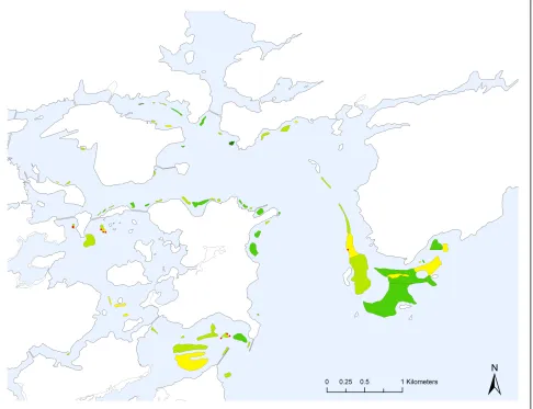
Figure 1. Eelgrass distribution for the Great Bay Estuary based on aerial photography from 10 August 2010 and ground truth surveys.
some beds shifted but there was little change in overall eelgrass area. Biomass increased in the southern Bay eelgrass beds with little change in distribution. In eastern Greenland Bay, there were decreases in percent cover and biomass. In 2010, eelgrass distribution continued to increase along the eastern side of Great Bay; new beds of seedlings appeared and those that first appeared in 2009 increased in both size and density in 2010.
In 2010, the abundance and distribution of nuisance seaweeds were noticeable throughout Great Bay, primarily growing within eelgrass beds and frequently noted during the ground truth assessments. The nuisance seaweeds largely comprised Gracilaria tikvahiae and Ulva lactuca.
In the Piscataqua River there was virtually no eelgrass in 2010, similar to the previous two years. In Little Bay, a small, new patch of eelgrass was found across from Adams Point in Furber Strait. Ground truth efforts revealed a few scattered eelgrass seedlings at one site in the
Piscataqua River near Adlington Creek. All of the eelgrass transplanted for the New Hampshire Port Mitigation Project of 1993-95, as well as the naturally-occurring eelgrass beds that served as reference sites for this project, have been lost (Beem and Short 2009). The small patch of eelgrass seen in Little Bay was 0.28 acres in size and comprised of seedlings recruited from Great Bay.
In Portsmouth Harbor (including Little Harbor and Back Channel), eelgrass distribution declined by 9% from 2009 to 2010. The loss of eelgrass distribution in the Portsmouth Harbor region
since 1996 is 153 acres, or 47%. Many of the shallower beds increased in percent cover, while the deeper beds in the outer harbor lost area and declined in percent cover from 2009 to 2010.
7
increases in nuisance seaweeds. Some new eelgrass beds consisting of seedlings appear each year but rarely survive long term.
Recommendations
1. Increase efforts to lower nitrogen loading to the Great Bay Estuary (GBE) to improve water clarity and reduce nuisance seaweeds throughout the estuary.
2. Throughout the GBE watershed, accelerate the implementation of sediment retention structures to reduce the direct sediment input to the estuary that contributes to elevated turbidity.
3. Secure funding for eelgrass research in GBE including investigations of the deep edge, Nutrient Pollution Indicator, and N isotope studies in order to examine trends and current status.
4. Continue annual monitoring of eelgrass in the GBE to detect trends in eelgrass itself and as an indicator of estuarine health.
5. Update the conversion of eelgrass percent cover to biomass through field surveys.
6. Restore eelgrass in Little Bay and the Piscataqua, Oyster and Bellamy Rivers.
7. Conduct quantitative monitoring of the wasting disease in the GBE.
8. Institute best management practices in the GBE to reduce boating and mooring impacts to eelgrass.
9. Create an improved map of potential eelgrass habitat for the GBE and use it in planning estuarine development to avoid impacts to areas where eelgrass could grow if water clarity were improved.
References
Beem, N. and F.T. Short. 2009. Subtidal Eelgrass Declines in the Great Bay Estuary, NH-ME. Estuaries and Coasts 32: 202-205.
Lee, K.S., F.T. Short, D.M. Burdick. 2004. Development of a nutrient pollution indicator using the seagrass, Zostera marina, along nutrient gradients in three New England estuaries. Aquatic Botany, 78: 197–216.
Muehlstein, L.K., D. Porter, and F.T. Short. 1991. Labyrinthula zosterae sp. Nov., the causative agent of wasting disease of eelgrass, Zostera marina. Mycologia, 83(2):180-191.
Nettleton, J.C. C.D. Neefus, A.C. Mathieson, and L.G. Harris. 2011. Tracking environmental trends in the Great Bay Estuarine System through comparisons of historical and present-day green and red algal community structure and nutrient content. Final Report to Great Bay National
Estuarine Research Reserve System, 101p.
Ochieng, C.A., F.T. Short, D.I. Walker. 2010. Effect of light on plant parameters and photosynthetic characteristics of eelgrass (Zostera marina L.): a mesocosm experiment. Journal of
Experimental Marine Biology and Ecology 382: 117–124.
Orth, R.J., T.J.B. Carruthers, W.C. Dennison, C.M. Duarte, J.W. Fourqurean, K.L. Heck, Jr., A.R. Hughes, G.A. Kendrick, W.J. Kenworthy, S. Olyarnik, F.T. Short, M. Waycott, S.L. Williams. 2006. A Global Crisis for Seagrass Ecosystems. Bioscience. 56: 987-996.
Rivers, D.O. and F.T. Short. 2007. Impact of grazing by Canada geese (Branta canadensis) on an eelgrass (Zostera marina L.) meadow, New Hampshire, USA. Marine Ecology Progress Series. 333: 271–279.
Short, F. and P. Trowbridge. 2003. UNH Eelgrass Monitoring Program, Quality Assurance Project Plan, Version 1, Final. University of New Hampshire and NH Estuaries Project, June 30, 2003.
Short, F. 2009. Eelgrass Distribution in the Great Bay Estuary for 2008. University of New Hampshire report to the Piscataqua Region Estuaries Partnership, April 21, 2009. 7p.
Short, F.T., E. Koch, J.C. Creed, K.M. Magalhaes. 2006. SeagrassNet monitoring of habitat change across the Americas. Biol. Mar. Medit. 13: 272-276.
Trowbridge, P. 2006. State of the Estuaries. New Hampshire Estuaries Program, Durham, NH. 32p.
Waycott, M., C.M. Duarte, T.J.B. Carruthers, R.J. Orth, W.C. Dennison, S. Olyarnik, A. Calladine, J.W. Fourqurean, K.L. Heck Jr., A.R. Hughes, G.A. Kendrick, W.J. Kenworthy, F.T. Short and S.L. Williams. 2009. Accelerating loss of seagrasses across the globe threatens coastal
9
Appendix