Photo:
Dam construction tends to have substantial envir
onmental and social ramifications. Grand Poubara dam, Gabon. © Marie-Clair
Introduction
For thousands of years, humans around the
world have been constructing dam-like
structures to impound water for drinking
and irrigation, to retain and control flood
waters, to provide hydroelectric power, to
allow for recreational amenities, and for
various other purposes (Willems and Van
Schaik, 2015). Yet, all too often, developers
and regulators fail to consider the
collec-tive environmental, social and economic
impacts of building dams, including the
displacement of communities and the loss of
ecosystem function and services (Babbitt,
2002; Poff
et al.
, 1997; Stanley and Doyle,
2003; WCD, 2000).
In 2000, the World Commission on Dams
estimated that 40 to 80 million humans had
CHAPTER 6
been displaced from their homes through
the construction of dams (WCD, 2000).
Dams can have major long-term
conse-quences for river health, to the detriment
of fish, wildlife and local communities that
are reliant on the river system for drinking
water, food, habitat and other uses (Brown
et al
., 2009; Tilt, Braun and He, 2009; WCD,
2000). Even small dams can have a major
impact on fish migration and downstream
fisheries, water quality, downstream water
supply and overall stream flow, including
the natural transportation of sediment and
nutrients needed to replenish downstream
forests and floodplains (Poff
et al.
, 1997).
Hydropower, also known as
hydroelec-tric power, generally provides low-carbon
electricity and is often a primary source of
energy for developing countries. Driven by
the rising demand for electricity in
devel-oping economies, as well as a call for
low-carbon energy as countries strive to meet
emission goals, global hydropower capacity
is projected to increase by 53%–77% between
2014 and 2040, and global electricity
gen-eration is expected to reach 6,000–6,900
terawatt hours (IEA, 2016, p. 249). This
expansion is likely to entail the construction
of thousands of large dams and tens of
thou-sands of small dams.
Much of the hydropower potential is to
be developed in the river valleys and
moun-tainous areas of tropical regions in Africa
and Asia. Since dam construction tends to
have substantial environmental and social
ramifications, the anticipated expansion of
hydropower is certain to affect numerous
communities and ecosystems, including
great ape and gibbon habitats (Zarfl
et al
.,
2015). Regardless of the projected
deleteri-ous effects—and despite the availability of
alternatives that are more sustainable, more
cost-effective and less likely to marginalize
certain social groups economically—the
green-lighting of large hydropower projects
appears to be unavoidable (DSU, 2016).
This chapter provides a review of the
projected expansion of hydropower and
the potential effects associated with the
pro-liferation of dams, including the impact on
apes and their habitat. It presents an initial
estimate of the scope of this impact, assessed
by overlaying projected dam build-out with
the geographic range of great apes and
gib-bons. The chapter also features three case
studies and a box that highlight best
prac-tices and strategies for avoiding and
miti-gating impacts.
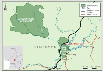
With reference to the Lom Pangar Dam
in Cameroon, the first case study considers
the challenges of implementing best
prac-tices designed to protect apes once a project
shifts from the planning to the construction
phase. The second case study, which
docu-ments recent events in Sarawak, in Malaysian
Borneo, explores how community activism
and collaboration between communities
and scientists can prevent the construction
of destructive dams. These case studies are
complemented by a box that focuses on a
system-scale hydropower planning and
design framework—“Hydropower by Design”
—as a method to fuse planning for energy
and water infrastructure with planning to
maintain or restore environmental and
social values. In recognition of the fact that
hydropower is not the only form of
renew-able energy production associated with
adverse impacts, this chapter features a final
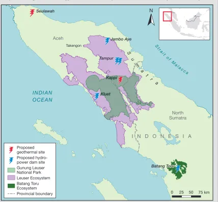
case study on the implications of a proposed
geothermal plant in Sumatra’s Leuser
Ecosystem, alongside planned hydropower
projects.
The chapter’s key findings include:
The negative impacts of dam
construc-tion on apes and their habitats across
Africa and Asia are likely to increase over
the coming years. Direct impacts include
habitat fragmentation and loss due to
the construction of dams and reservoirs,
and of the roads and transmission lines
associated with them; in turn, the roads
facilitate access to habitats, thus
ena-bling more widespread poaching and
other indirect impacts.
Hydropower development is likely to
impact apes in Asia more significantly
than in Africa, with gibbons identified
as particularly vulnerable.
Engagement, sharing knowledge and
raising awareness of the potential
adverse effects of large hydropower and
other renewable energy projects can
help at-risk communities avoid
expo-sure to severe environmental and social
impacts.
Cost–benefit analysis is a key step in the
planning phase of every large
renewa-ble energy project, particularly as it can
reveal excessive environmental and social
costs, issues related to carbon emissions
and potential problems regarding
deliv-ery on economic objectives.
The negative environmental and social
impacts of dams and other large
infra-structure projects are more likely to be
minimized when their development
planning incorporates a system-scale
approach and draws on existing tools
and processes, including the mitigation
hierarchy.
Once dam construction is in progress and
mitigation measures have been
imple-mented, ongoing monitoring and
man-agement of those measures are needed
to verify that they remain effective. Given
that both the life of a project and the
attention of financiers tend to be finite,
however, sustaining such activities
rep-resents a foreseeable and critical
chal-lenge to indefinite conservation.
Global Hydropower:
Drivers and Trends
Hydropower accounts for approximately
16% of global electricity generation; it is the
primary source of electricity in some
coun-tries, such as the Democratic Republic of
Congo, Lao People’s Democratic Republic
(Lao PDR) and Uganda. As of 2014,
hydro-power represented more than 70% of all
renewable electricity (IEA, 2016).
Hydro-power dams with storage capacity are
essentially storing energy and are thus able
to respond rapidly to changes in demand.
Within an electrical grid, this storage
func-tion can facilitate a higher proporfunc-tion of
renewable sources with variable generation,
such as wind and solar. Hydropower dams—
both conventional and pumped storage—
currently account for by far the greatest
proportion of the world’s electricity storage
(Kumar
et al
., 2011).
Due to the rising demand for electricity
in general—and for low-carbon and storable
energy in particular—hydropower is
draw-ing about US$50 billion in investments
per year, although investment in wind and
solar have eclipsed hydro in recent years
(Frank furt School-UNEP Centre/BNEF,
2017). In 2014, the Interna tional Energy
Agency forecast that by 2040, global
hydro-power output would grow by about 3,000
TWh, particularly if the world were to
transition away from fossil fuel sources of
energy to achieve the reduction in
emis-sions necessary to keep global temperature
increases below 2° C above pre-industrial
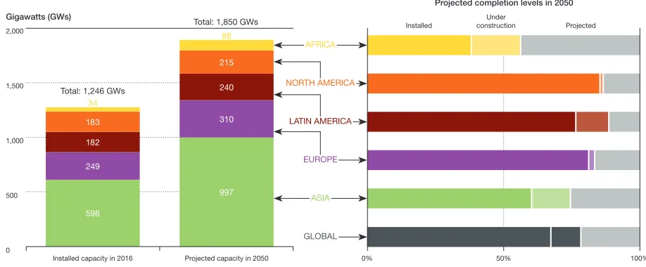
values (IEA, 2016, p. 250). Much of this
development is expected to occur in Asia,
although Africa will see the greatest growth
rate in installed hydropower capacity (see
Figure 6.1). The majority of hydropower
expansion (70%) will occur in river basins
that have the greatest freshwater
biodiver-sity and where the well-being of people—
including their food sources, livelihoods
and cultural values—is most directly tied to
healthy rivers and intact valleys (Opperman,
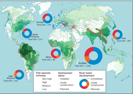
Grill and Hartmann, 2015; see Figure 6.2).
Figure 6.2 indicates that the hotspots
for hydropower expansion include the river
basins of the Amazon, the southern Andes,
the Balkan region of southeast Europe, and
FIGURE 6.1
Global Installed and Projected Hydropower Capacity
2,000
1,500
1,000
500
0
Gigawatts (GWs)
Projected completion levels in 2050
Installed capacity in 2016 Total: 1,246 GWs
Total: 1,850 GWs Installed constructionUnder Projected
Projected capacity in 2050 0%
AFRICA
NORTH AMERICA
LATIN AMERICA
EUROPE
ASIA
GLOBAL
50% 100%
Source: Opperman, Hartmann and Raepple (2017, p. 21), courtesy of TNC
598
997 310 240 215
249 182 183
34
North America
Total GW = 215
GLOBAL
Total GW = 1,850
Asia
Total GW = 997
Africa
Total GW = 88
Europe
Total GW = 310
Latin America
Total GW = 240
Fish species richness
Very high High Medium Low
Hydropower dams
Installed Under construction Planned
River basin development
Completed Under construction Planned
FIGURE 6.2
Hydropower Development in 2015: Dams Installed, under Construction and Planned
Adapted from: Opperman et al. (2015, pp. 16–17), courtesy of TNC
Data sources: Abell et al. (2008); IEA (2012); Lehner et al. (2011); Zarfl et al. (2015)
several regions that support ape
popula-tions: South and Southeast Asia (Cambodia,
India, Lao PDR, Myanmar and Nepal) and
vast areas of Africa.
Impacts of Hydropower
Extensive research has been undertaken on
the environmental and social impacts of
hydropower projects.1 In addition to
affect-ing the connectivity of organisms, nutrient
flows, upstream and downstream resources,
such projects typically involve the
construc-tion of associated infrastructure and
signifi-cant greenhouse gas emissions, as follows:
Hydrological connectivity.
Hydro-power dams and reservoirs affect the
down-stream transport of wood, sediment and
nutrients and disrupt the up- and
down-stream movement of organisms, including
fish and invertebrates (March
et al
., 2003).
Declines in fish populations negatively affect
human communities that rely on
migra-tory fish for food, both up- and downstream
(Richter
et al
., 2010).
and natural ecosystems, such as wetlands
and forests (WCD, 2000). Perhaps more
con-troversially, large dam development can
displace human communities, raising
seri-ous social justice questions, as those who
are displaced are often poor and lack
polit-ical influence (Scudder, 2005). Terrestrial
species, such as apes, are directly affected
by impoundment; as reservoirs fill up and
forests are replaced by open water, animals
who are not killed in the process suffer a
permanent loss of habitat. Further,
hydro-power reservoirs can convert previously
passable river channels into impassable
bar-riers for terrestrial apes and other species
(WCD, 2000). Thus, hydropower dams and
their reservoirs fragment ape habitat and
affect dispersal.
Impacts on downstream resources.
The
impacts of dams on downstream
environ-mental resources tend to be far greater than
the upstream impacts, even if they attract
less attention. As human livelihoods and
communities are often directly tied to
func-tioning river ecosystems, downstream
envi-ronmental impacts can have considerable
social costs (Richter
et al
., 2010). Large
reser-voirs trap nearly all sediment, except for
the smallest grain sizes, thereby disrupting
the delivery of sediment and nutrients to
downstream ecosystems, such as floodplains
and deltas (Kondolf, Rubin and Minear,
2014). By altering river flows, dams also
impair biological processes on which fish,
floodplain forests, and other downstream
species and ecosystems depend.
Impacts due to dam construction.
In
addition to a dam and a reservoir,
hydro-power development generally requires the
construction of access roads and
transmis-sion lines, both of which can fragment
for-ests and other habitats, affecting wildlife
habitat and movement (Andrews, 1990).
Roads, in particular, facilitate access to
pre-viously inaccessible areas, leading to an
increase in settlement, forest clearing and
hunting. During construction, major
pro-jects require thousands, or even tens of
thou-sands of workers; in tropical forest regions
of Southeast Asia and Africa, temporary
settlements near dam sites have been
asso-ciated with an increase in wild meat hunting
(Laurance, Gooseman and Laurance,
2009).
Greenhouse gas emissions
.
Although
hydroelectric dams are widely considered a
low-carbon energy option, some reservoirs
produce high emissions of greenhouse gases.
Reservoirs produce significant amounts of
methane, carbon dioxide and nitrous oxide
when the land is flooded and organic matter
rots and decays. Large dams2 are the
great-est single anthropogenic source of methane,
responsible for roughly 30% of all
anthro-pogenic methane emissions (Lima
et al.
,
2007, p. 201). The thermal, chemical and
biological conditions in reservoirs in the
tropics lead to higher methane emissions
than those associated with reservoirs
else-where (Fearnside, 2016a; Lima
et al.
,
2007).
Other dam-related greenhouse gas emissions
are linked to the use of fossil fuels during
site excavation and building materials such
as concrete in dam construction, land
clearing for reservoirs, resettlement sites,
transmission lines and access roads, and the
expansion of irrigated agriculture (Houghton
et al.
, 2012; Pacca and Horvath, 2002).
significant variables associated with the
impairment of dispersal among jaguars
(
Panthera onca
) (Silveira
et al
., 2014). Similarly,
in Costa Rica, the Reventazón hydropower
project fragmented a jaguar dispersal
cor-ridor; to “offset” the negative impact of the
reservoir, the developer funded reforestation
of land adjacent to the inundated area to
maintain a forested dispersal corridor (IDB,
n.d.). Developers also used a biodiversity
offset in Cameroon, where a forest reserve
was elevated to a national park to
compen-sate for the adverse environmental impacts
of the Lom Pangar Dam (see Case Study 6.1).
As noted above, the construction of roads
and transmission lines linked to hydropower
projects can also fragment wildlife habitat
(Andrews, 1990; White and Fa, 2014). In
discussing the various impacts of
hydro-power, the chapter highlights potential effects
on apes and their habitat.
Hydropower and Apes
The academic literature provides limited
information on how hydropower dams and
reservoirs affect apes and their habitats
(see Chapter 2, pp. 43–60). Since hundreds
of dams are proposed within the habitats
of great apes and gibbons, assessments of
the impact of hydropower expansion are
key to the conservation of these species and
their habitats.
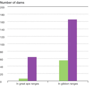
This section presents a simple spatial
analysis that was conducted to assess the
extent to which hydropower expansion
could affect great apes and gibbons and
their habitat. The analysis rests on two
cal-culations: (1) the number of installed and
planned hydropower dams in ape habitat;
and (2) the potential length of new roads
associated with planned hydropower dams.
Given the lack of information on reservoirs
and operations associated with potential
future dams, this assessment does not
eval-uate the impacts of reservoirs, flow
altera-tion, sediment delivery or greenhouse gas
emissions, nor does it consider the impacts
of resettlement areas, work camps,
quar-ries or other associated infrastructure, or
disturbances from transmission lines (see
Annex I).
To identify installed and planned
hydro-power dams, this assessment draws on two
sources: (1) the Global Reservoir and Dam
(GRanD) Database for installed dams, and
(2) a data set of future hydropower dams,
which comprises dams that are either under
construction or identified in planning
doc-uments (Lehner
et al
., 2011; Zarfl
et al
., 2015).
The GRanD Database covers all types of dams,
yet the majority of structures in ape ranges
are hydropower dams, or multipurpose dams
that include hydropower (Opperman
et al
.,
2015). The species ranges for great apes and
gibbons were mapped based on information
in the International Union for Conservation
of Nature (IUCN) Red List of Threatened
Species (IUCN, 2016b).
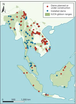
The number of hydropower dams in
each ape range was quantified by identifying
the intersection of dam locations with great
ape and gibbon species ranges. The next
step was to estimate the length of new roads
associated with hydropower dams that are
planned or under construction. It involved
calculating the potential road distance
between future dams and the roads closest
to them based on a “least-cost path” or “path
of least resistance,” while also taking the
local topography into consideration.
Importantly, both of the global data sets
from which dam locations were derived—
the GRanD Database and the data set of
future dams—contain errors of omission
and commission. Greater precision on dam
locations may be available from finer-scale
analyses that use data collected solely within
the geographic range of ape species. Dam
data collected at a finer scale may also
include additional information that could be
used to further improve the quantification
of impacts on ape habitat. If, for example,
dam data included the size of work camps at
each dam, that information could be used to
generate a more refined estimate of impacts.
Further, the species range data may also
contain errors. For instance, some proposed
dams that are known to overlap with
orang-utan habitat are not included in the
data-sets used in this analysis (see Case Study 6.3).
Nor does this study capture certain installed
N
Dams planned or under construction Installed dams IUCN great ape
ranges 0 500 1,000 km
Sources: IUCN (2016b); Lehner et al. (2011); Zarfl et al. (2015)
FIGURE 6.3
Number of Installed and Future
Hydropower Dams in the Ranges
of Great Apes and Gibbons
Key: Installed dams
Dams planned or under construction
Data sources: IUCN (2016b); Lehner et al. (2011); Zarfl et al. (2015) 200
180
160
140
120
100
80
60
40
20
0
Number of dams
In great ape ranges In gibbon ranges
FIGURE 6.4
N
Dams planned orunder construction Installed dams IUCN gibbon ranges
0 500 1,000 km
FIGURE 6.5
Installed and Future Dams in the Ranges of Gibbon
Species in Asia
Sources: IUCN (2016b); Lehner et al. (2011); Zarfl et al. (2015)
FIGURE 6.6
Estimated Length of New Roads
Associated with Construction of
Future Hydropower Dams in
Ape Ranges
Data sources: IUCN (2016b); Lehner et al. (2011); Zarfl et al. (2015) 1,200
1,100
1,000
900
800
700
600
500
400
300
200
100
0
Kilometers of new road
In great ape ranges In gibbon ranges
and planned dams that are sited near species
ranges and that can thus have a deleterious
impact on apes.
Nevertheless, the available data allow for
a preliminary assessment of the potential
impact of hydropower dams on great apes.
The analysis can be used to call attention to
the potential challenges of conservation
management and to allow governments,
scientists, conservation practitioners and
the hydropower sector to begin developing
strategies for avoiding, minimizing and
mit-igating impacts.
CASE STUDY 6.1
The Lom Pangar Hydropower Dam:
Infrastructure and Ape Conservation
in Cameroon
Introduction
Cameroon forms part of the Congo Basin rainforest and is home to some of the highest biodiversity on the continent. Its rich biodiversity, which represents 92% of Africa’s ecosystems, includes significant populations of great apes, such as the
western lowland gorilla (Gorilla gorilla gorilla) and the central
chimpanzee (Pan troglodytes troglodytes), two endangered
species whose habitats are in the rainforest (Republic of Cameroon, 2012). By dispersing seeds and maintaining forest health, these “forest gardeners” help to sustain the rich bio-diversity in Cameroon.
Regardless of their role as keystone species, great ape pop-ulations are undergoing a dramatic decline, largely due to poaching, disease and habitat loss, which are driven by demands for wild meat, a lack of law enforcement, corruption
and increased access to their once-remote habitat (Dinsi and Eyebe, 2016). Although Cameroon has made some effort to protect gorillas and chimpanzees—including by creating protected areas such as sanctuaries, reserves and national
parks (Lambi et al., 2012)—the ongoing expansion of
indus-trial agriculture, logging, mining and infrastructure develop-ment projects will result in massive losses of habitat unless rapid, targeted action is taken.
In order to achieve its goal of becoming an emerging economy by 2035, Cameroon, a developing and still largely agrarian country, has prioritized infrastructure development. Part of the plan is to add 3,250 km of tarred roads between 2010 and 2020, alongside the construction of new railway lines. Meanwhile, the country aims to reduce the gap between the supply and demand for energy through the construction of several hydroelectric plants and dams, a heavy fuel thermal power plant and a natural gas power station (Republic of Cameroon, 2009b, pp. 59, 61–3). Expanding energy genera-tion is central to the government’s ambigenera-tions.
Cameroon’s energy deficit is considered a serious impedi-ment to its economic growth and developimpedi-ment. In 2010, the
FIGURE 6.7
The Lom Pangar Hydropower Dam and Surrounding Area
Sources: © OpenStreetMap contributors (www.openstreetmap.org); UNEP-WCMC and IUCN (n.d.)
Deng Deng National
Park Mbam and Djerem
National Park
Lom Pangar Dam
Belabo Sana
ga Pangar Lom
Sana ga
Sanaga
Lom Pangar Dam
Deng Deng
Belabo
Garga Sarali
Deng Deng National
Park Mbam and Djerem
National Park
C A M E R O O N
0 10 20 30 km
N
Protected areaDam
country’s total installed electricity capacity—comprising on-grid, self-generation and off-grid—stood below 2,000 MW. Hydropower plants accounted for about 73% of the total elec-tricity produced in Cameroon in 2011, and thermal energy and solar sources made up some of the remainder. In order to increase installed hydropower capacity from about 719 MW in 2010 to 3,000 MW by 2020, the government intends to invest heavily in the energy sector (Africa–EU Energy Partner-ship, 2013). The Lom Pangar Hydropower Project (LPHP) was a critical first step in expanding Cameroon’s energy production. This section explores the project’s environmental impacts as well as efforts to mitigate them.
The Lom Pangar Dam
Cameroon relies on the LPHP as part of its efforts to provide a long-term solution to its energy supply gap. The primary purpose of the LPHP, which is designed to produce a modest 30 MW of electricity at the dam site, is to regulate the flow of the Sanaga River so as to increase and secure year-round power output for two existing downstream dams and an additional planned dam. While some estimates show that fewer than 20% of rural Cameroonians have access to elec-tricity, the main purpose of the Lom Pangar scheme and the dams that it facilitates downstream will not significantly enhance rural electrification. Instead, the LPHP is geared towards expansion of the aluminum smelters owned by Rio Tinto, the world’s largest mining company, which receives electricity at preferential rates (Ndobe and Klemm, 2014). The management of the Lom Pangar Dam was handed over to the national Electricity Development Corporation in June 2017. A second phase that includes the construction of a 30-MW hydropower plant and electrification of 13 localities in the East Region is ongoing (BRM, 2017; ESI Africa, 2017; World Bank, 2012a). The dam is located in a remote part of eastern Cameroon, near the confluence of the Lom and Pangar rivers. Financing for the LPHP is drawn from a pool of donors, comprised of the African Development Bank, the Development Bank of Central African States, the European Investment Bank, the French Development Agency and the World Bank (ADF, 2011). The total cost of the construction of the dam and associated infrastructure is just under US$500 million (Ndobe and Klemm, 2014).
As the lead financier on the project, the World Bank assigned the project its highest environmental and social risk rating, Category A (see Box 5.1 and Annex VI). This categorization is reserved for projects that are likely to have significant adverse environmental impacts. The project received this rating in part since “the dam site is located next to portions of the Deng Deng Forest that are critical habitats, particularly because of the presence of a viable population of gorillas, and a signifi-cant population of chimpanzees” (World Bank, 2009, p. 5).
The Deng Deng National Park
The Deng Deng National Park (DDNP), which overlaps with the LPHP area, harbors a significant population of the north-ernmost population of the western lowland gorilla. In 2010,
the Wildlife Conservation Society estimated that 300–500 gorillas lived inside the DDNP and in an adjacent logging concession (Live Science, 2011). The DDNP is also home to other threatened mammal species, including the central
chim-panzee, black colobus (Colobe satanas), elephant (Loxodonta
africana), hippopotamus (Hippopotamus amphibius) and giant
pangolin (Smutsia gigantea) (Boutot et al., 2005; EDC, 2011b).
When the World Bank agreed to finance the Chad–Cameroon oil pipeline in 1998, it insisted that the pipeline be rerouted to avoid any impacts on the Deng Deng Forest and its biodiver-sity (Dames and Moore, 1997; World Bank, n.d.-c). In fact, the potential impacts on the forest are among the reasons the Bank was reluctant to support the LPHP when Cameroon first sought financing in the early 2000s. At that time, the World Bank requested an environmental and social impact assessment (ESIA) to ensure that the LPHP would not have adverse effects on the Deng Deng Forest. In its review of the ESIA, the Bank cited concerns over potential impacts on great apes, especially during the construction phase, because of the large number of people expected to move to the area (EDC, 2011a, 2011b).
In 2012, in a sudden reversal of its earlier position, the World Bank decided to help finance the LPHP even though a portion of the Deng Deng Forest would be flooded by the dam’s
reservoir. To offset3 impacts, the Bank required that the forest’s
status be upgraded from a forest reserve to a national park (World Bank, 2012a, 2012b). The Deng Deng National Park was thus created by decree on March 18, 2010; its surface area, which initially covered 523 km² (52,374 ha), was extended to 682 km² (68,200 ha) in 2013. The Wildlife Conservation Society provides technical assistance in the management of the DDNP, based on an ad hoc service contract with Cameroon’s Ministry of Forests and Wildlife and its Electricity Development Corporation, with financial support from the French Development Agency (WCS, 2015b).
An enlarged Deng Deng functional ecosystem, referred to as the Deng Deng Technical Operations Unit, was created in 2010. Although it is yet to be gazetted, it includes the DDNP, two forest logging concessions, close to 20 community for-ests and two research forfor-ests. The Unit is spread out over a surface area of about 5,000 km² (500,000 ha); it harbors an estimated 990 gorillas who are roughly equally divided between the DDNP and the periphery of the park (IUCN,
2014c; Kormos et al., 2014). One proposal involves the creation
of an additional national park, the Lom Pangar National Park, to counteract hunting in the Mbam and Djerem National Park following development of the dam and the Chad– Cameroon pipeline. The proposed park would cover 1,775 km² (177,480 ha) within the dam project area and the pipeline corridor (Haskoning (Nederland B.V. Environment), 2011).
Threats to the Deng Deng Great Apes
loss, coupled with hunting pressures associated with artisa-nal mining.
Flooding
In September 2015, the contractors of the LPHP began a partial impoundment, or filling, of the dam’s reservoir (EDC, n.d.-b). This step was highlighted in the project’s ESIA (EDC, 2011b). Non-governmental organizations (NGOs) expressed significant concern that the full impoundment of the reser-voir, which would cover approximately 590 km² (59,000 ha), about 320 km² (32,000 ha) of which is forest, would flood critical habitat of the gorillas, trapping them on islands or push-ing them into populated areas (GVC, BIC and IRN, 2006). As a result, gorillas would be more exposed to poachers, the risk of disease transmission would grow due to more frequent con-tact with people, and human–wildlife conflict would increase
in line with crop raiding (Kalpers et al., 2011). Many other,
slower-moving species would likely drown during this phase.
Poaching
Large infrastructure projects tend to attract a huge influx of migrants in search of employment opportunities (WCS, 2011). In fact, the LPHP’s own ESIA indicates that an estimated 7,000 to 10,000 people were expected to move to the area seek-ing jobs and secondary employment (Goufan and Adeline, 2005, p. 6). In a 2011 memorandum of understanding with the
project contractor, China Water and Electricity Corporation, the Cameroon National Employment Fund agreed to facilitate the recruitment of an estimated 2,000 Cameroonians to work on the dam site (Agence Ecofin, 2012). Many others are likely to move to the project area without guaranteed employ-ment, giving rise to a peripheral economy that would prob-ably depend in part on poaching for wild meat and ivory trafficking, and that would also lead to further degradation of natural habitats.
In addition to permitting an influx of people during the con-struction phase of the dam, the Electricity Development Corporation intends to allow commercial fishing in the waters of the reservoir, anticipating an annual production of 1,500 tons of fish and an income of CFA 40 billion (US$65 million) (EDC, n.d.-a). Fishing opportunities are likely to draw even more people into the region, which is certain to increase pressure on biodiversity, including threats to the great apes (Goufan and Adeline, 2005; Mbodiam, 2016).
Transmission Lines
Although most tree species of high commercial value have already been exploited through illegal artisanal logging near the villages in the area, a further 5.28 km² (528 ha) of the Deng Deng Forest are to be cleared for the construction of transmission lines. Once the project goes live, it will present a risk of electrocution to wildlife (see Chapter 2 and Annex I).
Construction activities and noise pollution during the build-ing of the transmission lines will also disrupt and temporarily displace local wildlife. A transmission corridor with a width of up to 50 m will cut into ape habitat along the eastern edge of the DDNP. Since this area represents a marginal strip of their habitat, the impact will probably be limited, depending in part on dispersal routes from the flooded land (AfDB, 2011b).
Artisanal Mining
Although the project area holds important gold reserves, the government abandoned its plan to ensure gold extraction from the reservoir area prior to impoundment as it would have delayed the project (Mbodiam, 2010). In view of the huge mining potential of Cameroon’s East Region, however, the area is likely to attract artisanal and small-scale miners. Indeed, anecdotal evidence suggests that unauthorized mining oper-ations are already under way in the DDNP itself (Charles-Innocent Memvi Abessolo, personal communication, 2016). Apart from disrupting behavior, altering habitat, reducing food resources and dispersing wildlife populations, such mining activities are associated with increased hunting pressures and disease transmission (ASM-PACE and Phillipson, 2014). Similar links between artisanal and small-scale mining and impacts on apes have been documented in the eastern
Demo cratic Republic of Congo (Spira et al., 2017).
Mitigation Measures and Outcomes
In light of the adverse impacts identified through the ESIA process, the project developer and financiers set in place a number of mitigation measures. Nevertheless, environmen-tal concerns persist with respect to the DDNP’s staffing and viability.
Staffing of Deng Deng National Park
The LPHP relies on the deployment of rangers in and around the DDNP to control access to the park and to discourage and monitor poaching activities. The project put an empha-sis on higher numbers of staff during the construction period of the dam, when the area would be most heavily populated. Once construction activities are complete, the number of rangers in the area is to be reduced to a base-case level. The proposed number of guards to monitor the DDNP is one ranger per 10 km² (1,000 ha) within the park itself, and one per 25 km² (2,500 ha) in areas that are less vulnerable to poaching (EDC, 2011c; Charles-Innocent Memvi Abessolo, personal communication, 2016). Of the 58 managers and other staff members involved in securing and monitoring the DDNP and its periphery, only 17 are permanently assigned to the park; the rest are on temporary transfer from other services
(MINFOF, 2015)
.
The number of permanent staff is modest for a protected area of more than 680 km² (68,000 ha), not including the periphery, especially given that the environmental and social management plan calls for 70 community guards and eco-guards (EDC, 2011c; MINFOF, 2015). Compounding the problem of insufficient personnel is the inadequate training of most of the staff.
There is clear evidence that poaching continues despite the presence of ecoguards at the DDNP. In 2015, 1,270 kg of wild meat was seized, including 20 kg of chimpanzee, and 290 kg of monkey and gorilla (MINFOF, 2015).
The Viability of Deng Deng National Park
In part to ensure the viability of the great ape populations, the World Bank established the DDNP as a biodiversity off-set to be preserved in perpetuity. Yet, while the LPHP will facilitate access to the DDNP well beyond the period of con-struction, project financiers are expected to exit the project and thus cease monitoring by the end of 2018 (World Bank, 2012c). Therefore, a key question revolves around long-term viability and financial sustainability, including staffing and equipment for park surveillance.
The DDNP was expected to progress towards financial sus-tainability by drawing a growing number of ecotourists, but recent figures cast doubt on that assumption. In 2015, the park received only 23 visitors—17 nationals and 6 foreigners— yielding a total fee of CFA 88,500 (US$150). In addition to park visits that year, auction sales of seized illegal forest products from poaching and illegal logging raised only CFA 1.1 million (US$1,891) (MINFOF, 2015). The lack of investment in the DDNP is evidenced by the ongoing absence of a dedicated DDNP office building. The park’s temporary office is housed in one of the control posts.
Acknowledging that revenue from ecotourism is likely to be insufficient, the U.S. government insisted, as a condition of approving the project at the World Bank, that a portion of the water tariffs generated by hydropower installations be devoted to helping sustain the park financially. The installa-tions are located downstream of Lom Pangar and pay-ments are expected once the LPHP becomes operational. These details are included in the project appraisal docu-ment, which provides details on the World Bank’s proposed credit to the government of Cameroon for the LPHP (World Bank, 2012c).
Arrangements to allocate a portion of the water tariffs to the DDNP have yet to be made, however. The matter is of relative urgency as construction activities are due to draw to a close over the course of 2018. These arrangements were to be finalized prior to full impoundment of the reservoir, which is also expected in 2018. Even once those arrangements are made, it is unclear what role the project’s financiers will have in ensuring that the funds are utilized as intended, and what means they have to ensure compliance, should the agree-ment not be respected. The French Developagree-ment Agency ceased payments to sustain the park in August 2016, the anticipated deadline.
Conclusions
effects on important populations of great apes. Acknowledging the risks that the LPHP posed to these populations, the World Bank and other financiers stressed that instituting require-ments to guarantee the preservation of the Deng Deng Forest, through the creation of an offset, was the only hope of ensuring the survival of the region’s great apes (EDC, 2011a, 2011b, 2011c; World Bank, 2012a, 2012b, 2012c). However, evidence of the viability of these measures is clearly lacking, and the few reports from site visits point to deficiencies in efforts to guard the area against poaching. The lack of effec-tive and regular monitoring means that the current status of great ape populations in the park is unclear.
Furthermore, the financial sustainability of Deng Deng National Park remains uncertain. The completion of dam construction means the World Bank will reduce its oversight of the project, and the project completion date at the end of 2018 will signal the termination of the World Bank’s involvement, and that of
the African Development Bank, the European Investment Bank, the French Development Agency and other financiers. Meanwhile, the lack of progress in developing the arrange-ments to ensure that a portion of the water tariffs derived from hydropower production will be devoted to Deng Deng National Park suggests that the park’s viability is in danger. In conclusion, the DDNP and its great ape population remain at risk of further degradation once the project concludes, unless urgent action is taken to ensure oversight beyond the project completion date and a secure revenue stream for the park. Given that the attention of financiers is typically finite, large infrastructure projects such as the LPHP can present critical, yet foreseeable, challenges to indefinite conserva-tion. This case study demonstrates that even when the adverse impacts of an infrastructure project are acknowledged and assessed early on, they can nevertheless threaten the survival of endangered species such as gorillas and chimpanzees.
CASE STUDY 6.2
Community Resistance Against
Infrastructure in Malaysian Borneo:
The Case of the Baram Dam
Introduction
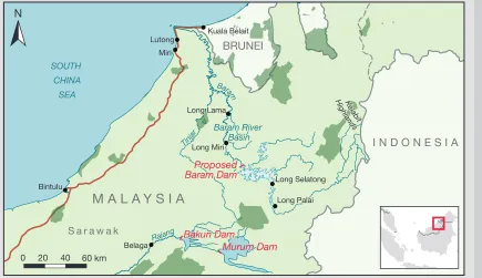
In 2006 the federal government of Malaysia embarked on a series of proposed economic corridors in an attempt to stimulate global and domestic investment in rural areas across the country. One of these corridors was the Sarawak Corridor of Renewable Energy (SCORE). It was to be estab-lished in Sarawak, one of two Malaysian states on the island of Borneo, and the largest of Malaysia’s 13 states. As part of SCORE, at least 12 dams were to be completed in Sarawak by 2030 (Shirley and Kammen, 2015). Two of these have already been completed: the Bakun and Murum dams (see Figure 6.8). Plans for the Baram Dam, which was next in line, were met with extensive community resistance from the indigenous communities in the Baram River Basin. Construction on the Baram Dam had been scheduled to start in 2014 but, by March 2016, after several years of community resistance, the state government legally withdrew its claim over the indigenous land earmarked for the dam site. This case study documents how a grassroots movement successfully
prevented the realization of a large infrastructure project that had been backed by the government.
Background
The Bornean Rainforest
The third largest island in the world, Borneo is part of the Sunda Shelf, which extends from Vietnam to Borneo and Java. The rainforests of Borneo are a biodiversity hotspot acknowledged to be among the world’s most species-rich ecosystems. At least 15,000 plants, of which 6,000 are found nowhere else in the world, grow in the swamps, mangroves and lowland and montane forests of the island. Borneo is home to an estimated 222 mammals (44 endemic), 420 birds (37 endemic), 100 amphibians and 394 fish species (19 endemic). Orangutans and gibbons share Borneo’s forests with a number of other primate species, including langurs (Semnopithecus), macaques (Macaca), proboscis monkeys (Nasalis larvatus), slow lorises (Nycticebus) and tarsiers (Tarsius) (WWF, n.d.-a, n.d.-b).
The Baram River Basin lies in northeastern Sarawak (see Figure 6.8). The waters originate in the Kelabit Highlands along the border with Kalimantan (Indonesian Borneo), flow through the mountain highlands and hills for more than 400 km, and lead into the South China Sea (Encyclopaedia Britannica,
FIGURE 6.8
Baram River Basin and the Bakun and Murum Dams
Sources: © OpenStreetMap contributors (www.openstreetmap.org); UNEP-WCMC and IUCN (n.d.) Kuala Belait
Baram River Basin Long Lama
Bakun Dam
Murum Dam
Long Palai
Proposed
Baram Dam
Kelab it Hig
hla nds
Long Lama
Belaga
Long Miri
Long Selatong
Long Palai Miri
Bintulu
Lutong Kuala Belait
Tinjar
Rajang
Baram
B
aramB aram
Baram River Basin
Bakun Dam
Proposed
Baram Dam
Murum Dam
Kelab it Hig
hla nds SOUTH
CHINA SEA
M A L A Y S I A
BRUNEI
S a r a w a k
I N D O N E S I A
N
1998). The forests of the Baram River Basin are home to a wide variety of fauna and flora, including gray gibbons.
Logging and Deforestation
In the past several decades logging has had a great impact on the forests of Sarawak; lush tropical rainforests are dis-appearing at an astonishing rate. Between 2005 and 2010, forest loss in Sarawak exceeded 2% per year, a rate higher than in any other major tropical forest territory. Between 2006 and 2010, about 9,000 km² (900,000 ha) of Sarawak’s forest was lost—43% was converted to oil palm and 21% to timber plantations (Lawson, 2014).
From 1981 to 2014 Sarawak was governed by Abdul Taib Mahmud, who has been accused many times of gross envi-ronmental and human rights abuses for personal gain (Global Witness, 2012; Straumann, 2014). During his tenure, the state became one of the largest exporters of tropical timber in the world. In 2010, Sarawak accounted for 25% of the world’s source-country exports of tropical logs, 15% of global tropical lumber and almost half of all tropical plywood —quite a feat for a forest estate that represents just 0.5% of the global total. Fewer than 5% of Sarawak’s intact forests remain in a pristine state, unaffected by logging or plantations, with dire consequences for its wildlife and indigenous com-munities, which depend on the forests (Global Witness, 2012).
The Indigenous Population
The people of the Baram River are mainly indigenous Kayan, Kenyah and Penan, with a few Iban, Kelabit and Saban com-munities. They depend on healthy rivers and forests for their livelihoods. The native customary rights (NCR) of indigenous groups over their ancestral land are enshrined in the Sarawak Land Code and protected under the Malaysian Constitution
(Colchester et al., 2007). Nevertheless, the government has
proceeded to license nearly the entirety of Sarawak, includ-ing land claimed for NCR, for logginclud-ing and plantations, while simultaneously blocking attempts by communities to have their NCR land mapped, recognized and gazetted (Global Witness, 2012).
The people of Baram have a history of resisting deforestation in the area. Since the late 1980s, when logging and agricul-tural expansion began to change the landscape of Sarawak, indigenous communities resisted through protests and block-ades against logging companies. Resistance has often led to arrests and political persecution, with the result that several prominent activists fled Malaysia in the 1990s. In the past several years the government has relaxed its approach to environmental and human rights activists; however, deadly conflicts are still occurring between indigenous activists and
land developers.4
SCORE Hydroelectric Dams
The government of Sarawak and the dam builder, Sarawak Energy Berhad (SEB), have claimed that the energy pro-duced by the SCORE dams would transform Sarawak into a developed state by the year 2020. Yet the project’s 12 large
hydropower dams were primarily designed to power the expan-sion of oil palm plantations and energy-intensive industries (Shirley and Kammen, 2015).
After five decades of delays, the Bakun Dam was opened in 2011, but since then it has only operated at half-capacity (Sarawak Report, 2014). This was the first of the SCORE dams to be built; looming at a height of 205 m, it is the largest dam in Asia outside of China (International Rivers, n.d.-a). The Murum Dam, the second in the SCORE series, officially opened in September 2016 (Then, 2016). The government began preliminary work on the Baram Dam in 2011 but officially canceled all works in March 2016, due to grassroots resist-ance. The Baleh Dam is next in line to be built, and while the government approved its environmental and social impact assessment in 2016, the details of the proposal and the ESIA
have not been publicly released.5
The acronym SCORE stands for Sarawak Corridor of Renew
able Energy, but the adjective “renewable” is inaccurate in this
context, as the SCORE development plan entails the exploi-tation of coal reserves, the construction of new coal power plants and deforestation to accommodate the expansion of oil palm plantations (Shirley and Kammen, 2015). The power generated by the SCORE dams is intended to feed energy-intensive industries, such as aluminum and steel produc-tion. SEB, a state-owned electricity supplier under Sarawak’s Finance Ministry, is responsible for the planning of all hydro-power projects and coal plants in Sarawak. It is chaired by Abdul Hamed Sepawi, a cousin and one of the closest business allies of Sarawak’s former chief minister, Taib Mahmud (Bruno Manser Fonds, 2012a, 2012b).
The Renewable and Appropriate Energy Laboratory (RAEL), an independent energy research facility at the University of California, Berkeley, recently conducted an in-depth analysis to explore the implications of building the SCORE dams, and the potential for clean energy solutions for Sarawak. The RAEL research agenda covered three main project areas: (a) mod-eling long-term, utility-scale electricity-generation alternatives for Sarawak to determine trade-offs across different technol-ogies; (b) exploring to what extent rural communities in dam-affected areas would be able to satisfy energy access needs using local resources; and (c) demonstrating a rapid assess-ment method for estimating the impact of mega-projects on biodiversity. RAEL’s research results call into question the necessity of building additional dams in view of potential lower-cost, lower-impact clean energy alternatives in the state (Shirley and Kammen, 2015).
growth rate and a very aggressive 10% energy demand growth rate at a lower cost than the SCORE plan. The Bakun Dam alone satisfies one-third of the demand by 2030 under a 10% growth assumption, and half of the demand under a 7% growth assumption. Two existing dams (Bakun in central and Batang Ai in southwestern Sarawak) and recently installed combined gas and coal-fired genera-tors are sufficient to meet demand at a 10% growth rate if properly managed (Shirley and Kammen, 2015).
Social and Economic Impacts: Baram, Bakun and Murum
Although most of the dams are sited on native land, indig-enous communities have not been properly consulted and are being forcefully relocated. The Baram Dam would have created a reservoir covering around 400 km² (40,000 ha) of forest and would have displaced up to 20,000 indigenous people (Lee, Jalong and Wong, 2014). Communities that were displaced because of construction of the Bakun and Murum dams have been severely impacted by relocation. In 1998 the government of Sarawak relocated about 10,000 people to make way for the Bakun Dam. Two decades after resettlement, the displaced people are still struggling to eke out a living. The government required resettled com-munities to pay for their own housing, which forced many families into debt. Communities that had been able to catch fish in the river, hunt and gather forest products no longer have access to forests, and pollution from the dam has decimated fish stocks. Each family was promised 0.04 km² (4 ha/10 acres) of farmland but was only provided 0.01 km² (1.2 ha/3 acres), much of it a half-day’s journey away from the resettlement sites; moreover, a large portion of the “farmland” is infertile, rocky and sandy land. This has not been enough to sustain a living (International Rivers, n.d.-a). Similarly, communities displaced in 2013 by the Murum Dam are struggling in their resettlement sites. Construction of the dam began in 2008, even though neither the initial ESIA nor the resettlement action plan had been made public. The project developers did not begin an ESIA until after construction was already under way, and the resettlement plans were leaked in 2012 (International Rivers, n.d.-d). The Sarawak government began resettling around 1,500 indigenous people from the Murum Dam area in July 2013. The resettlement sites are surrounded by vast expanses of oil palm and land earmarked for logging concessions to politically connected timber companies (International Rivers, n.d.-d). As of January 2018, the communities still had not been allocated land to cultivate. During a visit led by the Sarawak-based NGO Save Rivers to the Kenyah resettlement site at Tegulang in October 2016, the
resi-dents remarked that they felt as though they were “in jail.”6
The dams also inflict considerable economic costs on the state. The Bakun Dam was built over the course of two decades at a total cost that was astronomically higher than projected. The dam was originally expected to cost MYR 2.5 billion (US$564 million), excluding transmission and all non-dam-related infrastructure. While the official expenditure figures have risen to MYR 7.4 billion (US$1.7 billion), research-ers from the National Univresearch-ersity of Singapore put the cost of the Bakun Dam at MYR 15 billion (US$3.5 billion), six times the original estimate (Sovacool and Bulan, 2011). Construction began in 1994 and the dam was meant to be operational in 2003. It was not completed until 2011, but even today, it is not running at full capacity. The Murum Dam has also incurred significant cost overruns. It cost Sarawak MYR 530 million (US$120 million) more than the original price, according to the 2016 Auditor-General’s report (Kallang, 2016).
Environmental Impacts
If the SCORE vision were to be realized as initially planned, 2,425 km² (242,500 ha) of rainforest would be destroyed to allow for the impoundment of reservoirs and the construction of dams, and additional land would be cleared for resettle-ment sites. The Bakun Dam reservoir alone covers 695 km² (69,500 ha)—about the size of Singapore (Kitzes and Shirley, 2015). Given that the rainforests of Borneo are among the most biodiverse terrestrial ecosystems in the world, it comes as no surprise that the three dams—Bakun, Baram and Murum—would have a tremendous impact on the rich biodi-versity of the area.
The RAEL team conducted biodiversity impact studies for these three SCORE dams and uncovered alarming facts. Using global species range data, geographic information system (GIS) tools and species area scaling relationships, the team predicted three distinct measures of biodiversity impact: the total number of species affected by the dams, the number of individuals affected and the number of potential species extinctions that could result (Kitzes and Shirley, 2015). The study found that the dams would have a negative impact on at least 57% of Bornean bird species and 68% of Bornean mammal species. The affected species include endangered and critically endangered birds and mammals,
such as Abbott’s gray gibbon (Hylobates abbotti), the
Bornean bay cat (Catopuma badia), the Bornean
peacock-pheasant (Polyplectron schleiermacheri), the flat-headed
cat (Prionailurus planiceps), the smoky flying squirrel
(Pteromyscus pulverulentus), Storm’s stork (Ciconia stormi),
the Sunda otter civet (Cynogale bennettii) and the Sunda
pangolin (Manis javanica). In addition, the study found that
two-thirds of all tree and arthropod species would be impacted, resulting in four tree and 35 arthropod species extinctions. The number of species extinctions does not take into account the potential extinction of subspecies or local populations, both of which may be critical to species’ long-term viability (Kitzes and Shirley, 2015).
The study also provided numbers on individual organisms that would be lost—arthropods, birds, mammals and trees that
would perish because of loss of habitat from clear-cutting and inundation. The three dams alone would cause the loss of an estimated 3.4 million individual birds and 110 million individual mammals. To put this into perspective, that is more individual birds than were counted in the North American Breeding Bird Survey in 2012 and more individual mammals than the entire inventory of cattle in the United States in 2012. A minimum of 900 million individual trees and 34 billion indi-vidual arthropods would also be lost (Kitzes and Shirley, 2015).
Community Resistance in Baram
The Formation of Save Rivers
In 2011 the state government began to hold briefing ses-sions about the proposed Baram Dam and started construc-tion of the road to the dam site. In October of that year, eight Sarawak-based civil society organizations that were con-cerned about the implications for the people and the forests of Baram joined forces to form the Save Sarawak Rivers Net-work (Save Rivers), whose mission is to build broad-based support to educate and mobilize the public against the plans to build dams.
The first actions by Save Rivers were designed to raise awareness among the urban and rural populations about the dam and its implications. On February 16–18, 2012, the group organized an initial statewide conference in the city of Miri for representatives from the Bakun, Baram and Murum river basins. Following the conference, delegations from Save Rivers conducted roadshows, traveling by vehicle and boat to remote villages throughout the Baram river basin to inform communities about the proposed Baram Dam and its implica-tions for them. At that point, the preliminary ESIA had been completed by Fichtner, a German consulting company employed by SEB; however, the full ESIA had not yet been initiated and the majority of impacted villages had not been informed about the plan to build the dam. The roadshows were conducted in all of the villages that were at risk of inundation; most villagers heard about the dam construction plans for the first time during these events.
Community Organizing, Nonviolent Direct Actions, Awareness Building
communities and voicing the communities’ concerns to gov-ernment officials.
The next large event occurred in May 2013, alongside the International Hydropower Association (IHA) conference that was hosted by SEB in Kuching, in western Sarawak. Save Rivers brought together residents from Baram, local and international politicians, and local and international NGOs for an alternative conference on indigenous rights that included several protests and marches held outside of the IHA venue. The alternative conference drew supporters from around the state and around the country, greatly increasing local and national awareness about the issues and building solidarity. In August 2013 the Sarawak government took the first steps to extinguish the land rights of indigenous communities near
the Baram Dam site—without their consent (Lee et al., 2014).
In response, Save Rivers traveled up and down the Baram River, helping the communities establish two blockades to prevent dam workers from accessing the proposed site of the Baram dam. One blockade was built centrally among Baram villages as a rally point. The second blockade was con-structed at the beginning of the access road to the dam site near Long Lama. The blockades prevented construction, sur-veying work and logging at the proposed dam site, halting all progress. The blockades not only physically disrupted work on the dam, but also acted as community centers and obser-vatories for monitoring illegal logging. In spite of numerous government attempts to dismantle the structures and disperse community members, the blockades have been continuously
maintained and managed since October 2013. They are the longest-running blockades in the history of Sarawak, and their maintenance has required significant efforts. When the block-ades were formed, Save Rivers also helped the communities file a suit against the government, in which they collectively demanded that their customary lands be returned. In conjunction with blockades, rallies and roadshows, Save Rivers organized cross visits between Baram villages and communities that were forcefully relocated because of the Bakun Dam. During these visits the people of Baram were able to speak directly with individuals who had been evicted and witness for themselves what happens during resettlement. Save Rivers also organized several large conferences in Baram to distribute information and strategize among communities, as well as various acts of nonviolent direct action throughout the country. One of the larger events occurred in June 2015 during a visit by then chief minister Adenan Satem to the town of Long Lama for a bridge inauguration. Save Rivers rallied hundreds of Baram residents to line the streets of Long Lama and express their opposition to the dam. Their voices were heard loud and clear, and the chief minister acknowledged Save Rivers in his speech (Radio Free Sarawak, 2015).
Research and Publications
In addition to raising awareness and promoting community organization, the campaign against the Baram dam coordi-nated with local and international experts to produce several publications and studies about the situation.
A fact-finding mission to determine how SEB and the govern-ment had engaged with the communities of Baram was con-ducted by local experts and supported by several local and international groups. Based on detailed interviews in 13 vil-lages along the Baram River, the mission report reveals how indigenous communities were denied information, prevented from participating in studies and decision-making, coerced into accepting the dam through threats and intimidation, and thus denied their rights, as ascribed under international agreements and treaties, to their lands and territories, self-determination, and to free, prior and informed consent (see Chapter 2). The
report, entitled No Consent to Proceed, received significant
media attention (Lee et al., 2014).
Save Rivers also worked with experts from the University of California to increase transparency on energy development in Sarawak. As mentioned above, the RAEL team produced three studies that greatly informed the campaign. The stud-ies show in detail that the energy that would be produced by SCORE is superfluous, and that the impacts on biodiversity would be severe. They also lay out a plan to increase rural energy through small renewable systems, such as solar and micro-hydro structures (Kitzes and Shirley, 2015; Shirley and Kammen, 2015; Shirley, Kammen and Wynn, 2014). The RAEL studies were used to strengthen community resil-ience, as well as to increase awareness in the government. In March 2015 Save Rivers organized a trip to distribute the RAEL studies throughout Baram. The results reaffirmed and gave credence to the demands of the people. Three months later Save Rivers organized a meeting that brought together local activists, politicians, Dan Kammen, the founding direc-tor of RAEL, and Chief Minister Satem to discuss the energy options and the demands of the Baram people. Following the meeting, Satem, who has since died, asked for an alter-native proposal to the SCORE dams, which was submitted in July 2015. In January 2018, the authorities had yet to respond to the submission. The campaign was working to resubmit the proposal and arrange a meeting with the new chief minister.
International Solidarity
In addition to networking among stakeholders, researchers and politicians, the campaign against the Baram Dam gen-erated considerable international solidarity. International organizations have provided funding, strategy, media and networking support. In October 2015, Save Rivers, the Borneo Project and the Bruno Manser Fund organized the World Indigenous Summit on Environment and Rivers (WISER) to mark the second anniversary of the blockades. WISER brought together indigenous leaders who are fighting dams around the world, including the late Goldman Prize winner Berta Cáceres. Together, the WISER participants wrote the Baram 2015 Declaration on Dams and the Rights of Indigenous People. The Summit rallied more than 1,000 people from Baram at various events, building solidarity and drawing significant media attention.
Victory: Land Returned to Communities
On March 15, 2016, the Sarawak government revoked its claim to the land that would have been used for the Baram Dam, thereby legally restoring indigenous land rights and officially stopping all progress on the dam (Mongabay, 2016a). Stopping the Baram Dam was an unprecedented success for indige-nous rights in Sarawak. This victory was won at a time when dams around the world were under increasing scrutiny. For Malaysia, where the space for civil society is constantly shrink-ing, the success of Baram gives hope to other struggles for rights and the environment (HRW, 2016).
Challenges and the Path Forward
The campaign experienced many challenges along the path to defeating the dam. One of the principal divisive tactics of the government was to divide the communities and label the people who opposed the dam “anti-development.” The gov-ernment also removed anti-dam village leaders, or headmen, and replaced them with pro-dam headmen.
In Sarawak activists often face exclusion from society. Many people choose to remain silent for fear that the government will withdraw support in the form of development projects and education grants. Leaders of the opposition to the Baram Dam have been socially ostracized by friends and family members who do not agree with the campaign.
Activists have also faced legal battles. SEB tried to sue 23 activists for tampering with samples and equipment at the dam site. As the land for the dam site has now been legally returned to the community, SEB has withdrawn the suit. In spite of the victory against the dam, the blockades remain intact and running. The blockades now serve as a venue for community events instead of obstructing access to the dam site. Communities are wary that a new government may try to reinstate the project. To gear up for this possibility, Save Rivers is now focusing on campaigns to build long-term land rights protection measures in Baram through the Baram Conservation Initiative. The Initiative actively seeks to facili-tate development systems that are chosen and managed by rural communities, in harmony with their environment. At the time of writing, the two main program aims were to establish a community-managed conservation zone and to build sus-tainable village-scale electrification systems, such as micro-hydro and solar systems.
A key lesson from the campaign against the dam is the importance of raising awareness in communities. Without proper knowledge of the situation, communities cannot act. Increasing awareness allows people to choose how to respond to projects.
BOX 6.1
Hydropower by Design
IntroductionThe hydropower sector, governments, scientists and civil society groups have worked, often collaboratively, on finding ways to improve the sustainability of hydropower development and to achieve more balanced outcomes between energy development and other values. More balanced outcomes can occur at two scales:
the planning and siting of new dams at the system scale (that is, at the scale of a river basin or a region); and the design and operation of individual dams.
Recognizing that the sustainability of hydropower is a func-tion of the system and individual scales, The Nature Conser-vancy (TNC) developed an approach that integrates both scales: “Hydropower by Design.” The approach encompasses a range of methods and tools to improve the planning, siting, design and operation of hydropower, as well as the
mitiga-tion of its adverse impacts (Opperman et al., 2015, 2017; TNC,
WWF and UoM, 2016). Hydropower by Design is a short-hand term for integrated, system-scale planning and man-agement using a number of existing tools and processes, including the mitigation hierarchy (see Chapter 4, p. 119). By applying this approach, hydropower developers can:
avoid building dams at the most damaging sites by directing development towards sites that result in less impact, specifically by identifying the spatial arrange-ment of dams that can produce optimal outcomes across social, environmental and economic values;
minimize impacts,such as through best practices during construction;
restore key processes and resources by adapting the design and operation of individual dams (such as build-ing fish passage structures and managbuild-ing the release of environmental flows to maintain or restore downstream floodplain fisheries); and
offset adverse impacts that cannot be avoided, minimized or restored by investing in compensation to achieve no net loss of biodiversity.
Some progress has been made in the development of approaches that serve to improve the environmental and social performance of individual hydropower dams. Among these is a tool to measure the relative sustainability of pro-jects—the Hydropower Sustainability Assessment Protocol (‘the Protocol’) (IHA, 2010). However, a number of major impacts from hydropower cannot be mitigated effectively at the scale of a single dam and project-level sustainability cannot address the complex issues posed by multiple hydropower developments across a river basin or region.
With respect to apes, certain impacts from hydropower can be addressed through best practices at the project scale, but some of the most important conservation objectives—such as the maintenance of large blocks of intact forest or con-nectivity between forests—can only be addressed through system-scale approaches that influence the spatial configu-ration of hydropower development, encompassing dams, reservoirs, roads and transmission lines.
When applied to ape conservation, the principles of Hydro-power by Design can be organized to follow the mitigation hierarchy: