Published online June 10, 2014 (http://www.sciencepublishinggroup.com/j/ija) doi: 10.11648/j.ija.20140201.11
Settlement pattern study of Chalcolithic sites in the
Gamasb river basin of central Zagros, western Iran
Mohammad Reza Saeedi Harsini
SAMT, A Humanistic Publication Centre, Tehran, Al Ahmad Street, Tehran, Iran
Email address:
To cite this article:
Mohammad Reza Saeedi Harsini. Settlement Pattern Study of Chalcolithic Sites in the Gamasb River Basin of Central Zagros, Western Iran. International Journal of Archaeology. Vol. 2, No. 1, 2014, pp. 1-5. doi: 10.11648/j.ija.20140201.11
Abstract:
The Gamasb River Basin survey project carried out from 2004 to 2006 in the Central Zagros West of Iran was aimed at obtaining the occurrence of Chalcolithic sites across the area. In discussion of archaeological landscape, human activities have generally been regarded as external forces to either landscape changes or changes in archaeological material structures. An important aspect of any approach to natural and archaeological resource problems lies with the ability to represent spatially those resources and elements of the environment. Geographic Information Systems (GIS) provide a suitable base for such a representation and one which establishes the necessary analytical tool. The main goal of present paper is to make a contribution toward application of GIS to map the distributions of archaeological materials on the cultural landscape as well as examining the role of GIS for spatial analyses. Through the use of statistics based on findings from a case study in Iran this study found that the location of archaeological sites exhibit non-random tendencies or patterning throughout a landscape. This patterning is a result of past people’s tendency to interact with the landscape in “favorable” settings. Changes in land use patterns diminish the archaeological site distribution patterns and consequently the archaeological landscape values.Keywords:
Chalcolithic Iran, Gamasb River Basin, Central Zagros, Environmental Variables, Spatial Analysis1. Introduction
Between 2004 and 2006 an archaeological project was undertaken to study distributional patterns of archaeological materials in the Central Zagros region of western Iran. This study was mainly concerned with the Landscape Archaeology in general and reconstruction of Chalcolithic (ca. 5700-3300 B.C.) settlement patterns in particular in Central Zagros. The primary aim of this project which combined a set of digital archaeological methods was to improve understanding of settlement system and land organization of Chalcolithic period and ultimately the human behavior behind this aspect of settlement system (Niknami and Askarpour 2013). Another main priority was to display graphically cultural resources of a functional or temporal class in relation to environmental features which provides archaeological heritage manager with the necessary tools to locate and manage known cultural heritage and can enable them to protect archaeologically or culturally significant sites. Use of geographic information system (GIS)-based mapping to locate areas of high potential for prehistoric archaeological sites are becoming increasingly popular among archeologists. Knowledge of the
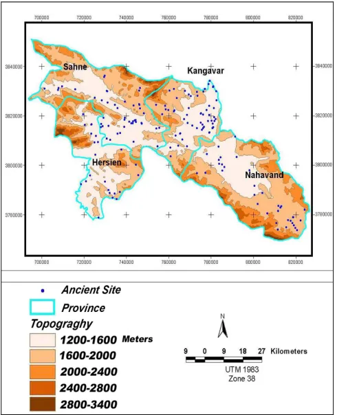
environmental variables influencing activities of original inhabitants is used to produce GIS layers representing the spatial distribution of those variables. The GIS layers are then analyzed to identify locations where combinations of environmental variables match patterns observed at prehistoric sites. Presented here are the results of a study to locate high-potential areas for prehistoric (Chalcolithic) sites in a largely surveyed area of about 11000 square km in the Gamasb River Basin, Western Iran, including details of the analysis process. The project used environmental data from over 169 known sites in the region and the results corresponded well with known sites in the study area (Fig. 1).
Generally, it is assumed that the selection of sites by original inhabitants was at least partially based on a set of favorable environmental factors, such as distance to water or topographic settings. Another assumption is that modern day GIS layers consistently characterize changes from the prehistoric condition of the region sufficiently well that they can be used to help discover additional sites. The GIS database covers an area of about 11000 km2, covering the majority of the Gamasb River Basin and its immediate environs. The current basic raster and vector layers of the GIS data base include: elevation (derived from the various relevant for example geological, hydrological and topographic 1: 50.000 maps) as well as archaeological sites and field survey transects (from project surveys and other sources) (Fig. 2). Additional derived data layers showing different distance categories, or buffer zones, from: roads (Fig 3), streams, faults, archaeological sites, and ancient roads were then generated from the data above. Additional data have recently been added that were derived from the 1: 50,000 maps, including reclassifications and distance measurements from sites, ancient roads, and hydrology.
Fig. 2. Topographic map of the Gamasb River Basin study area, indicating location of sites discovered during ground survey.
In all there are currently over 169 point, vector, and raster data layers in the database. These data are used to conduct a variety of analyses of the prehistoric site locations and the development of predictive models of archaeological sites of Chalcolithic periods [1].
Fig. 3. Buffer zone of sites distance to the known ancient roads.
2. Concepts
Over the past two decades, there has been a growing interest among archaeologists in constructing spatial models for patterning prehistoric site locations. This renewed interest is the result of both rapid developments in GIS technology that make the modeling process more efficient (Niknami and Saeedi Harsini 2006, Kvamme 1992, Allen et al. 1990, Dalla Bona 1994, Maschner 1996) and public pressure to conduct cultural resource activities in a cost-effective manner. The model is based on the assumption that the most important factors controlling prehistoric settlements and activity locations were physical and biotic attributes of the landscape (Dalla Bona 1994: 17). This is in contrast to more technologically complex societies, where social, ideological, and political forces can take precedence over environmental factors in influencing settlement location. As a result of this assumption, the modeling efforts rely on a series of biophysical variables (e.g. slope, elevation, soils, proximity to various water sources, vegetation) to construct models. The reliance on these types of variables has led to criticism that the resulting models are environmentally deterministic [Kohler 1988: 9]. Although archeologists who construct site patterning models recognize the importance of cultural factors in the location of settlements, they contend that the temporal control needed to establish contemporaneity between sites is usually lacking. Consequently it is difficult, if not impossible, in most situations to include these variables in the modeling process (Brandt et al. 1992: 269, Kvamme 1997: 1-2).
reflect spatial organization across the landscape during the prehistoric period (Dalla Bona 1994: 16-17, Conolly. and Lake, 2006: 180-181). The model, through its geomorphological landscape component, incorporates the third and fourth dimensions of time and buried landscapes/surfaces for areas with higher probabilities for buried cultural resources. This was done for Gamasb River valley and a limited number of small upland areas. This is a unique aspect of the model that has not been previously attempted by other modeling efforts on this scale.
3. Material and Methods
The collection of site characteristics data has been carried out through conducting a site discovery survey and followed by transect site sampling, site mapping and general description and documentation (Niknami 2004). A dictionary of landform terms, a list of standardize mapping symbols, a number of forms for recording site observation were included in the program. The research and management continuity attained by the use of standard field surveying procedures has resulted in the critical evaluation of recorded site information involving both quantitative and qualitative features. Analysis of site data in the course of conducting the systematic survey has provided opportunities for critical evaluation of the operating procedures with respect to research goals which had been addressed in the surveys. This has sometimes involved revisit to earlier recorded site to raise documentation up to the level of other sites, to fill in the gaps between sites, or to reconcile inconsistencies between different site recorders. Most of the site attribute data recorded during the field survey is stored, manipulated and maintained in a GIS file format. The Chalcolithic site characteristics database file include observation on over 7 variables for each site and include basic site information such as site number, area project number, morphological information and sample transect information. Environmental data layers used in this study consists of map layers which include most of the basic map layers such as elevation, slope, aspect, vegetation and proximity to the various resources and ancient roads and communities. The final step in setting up the data for site analysis involves combining the site characteristics data with the GIS environmental data and transporting both to the relevant statistical software systems (for a complete review on the capability of the technique used see (Ebert 2004).
4. Results
The primary objective of the model project was to create a series of accurate digital maps capable of alerting planners to the presence of potential archaeological sites. By using Geographic Information Systems, digital maps were created that delineate areas of high, medium, and low archaeological site potential based on statistical correlations between environmental attributes and known
archaeological site locations. Linking this information with areas of high, medium, and low survey coverage directs where archaeological survey efforts should be concentrated.
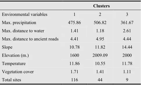
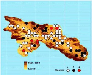
The site characteristics data collected during fieldwork and the environmental information were combined for exploratory analysis and the generation of site clusters. A cluster analysis produced groups of sites that reflect the configuration data from the study area. In addition to the site characteristics data analyzed, information concerning the environmental context of site settlement such as aspect, slope, distance to road, distance to water resources, temperature and elevation seemed to be more important variables that can be factored into the processes of site classifications. All sites fall into three clusters arranged in a positive linear pattern suggesting that site distribution patterns are highly correlated across study area and exhibit a range of potential patterns on different environmental settings. A K-Means Cluster Analysis algorithm was applied with the main objective to identify groups of sites with similar spatial characteristics. As this algorithm requires the number of clusters to be specified, a preliminary Hierarchical Agglomerative Cluster Method was applied and after the Ward criterion 3 clusters were identified (Table 1). The first cluster incorporates 116 sites, they occur on lower elevation (a average of 1600 m. above see level), they also provide highest values of vegetation cover as well as a higher mean value of annual temperature. They are close to water sources and slope values on these sites are fairly low. On the basis of these characteristics the sites of this cluster is defined to have a strong correlation with good agricultural soils, and distinctively suitable for the farming activities.
Table 1. Clustered frequency distribution of Chalcolithic sites based on environmental parameters across the study area.
Clusters
Environmental variables 1 2 3
Max. precipitation 475.86 506.82 361.67
Max. distance to water 1.41 1.18 2.61
Max. distance to ancient roads 4.41 4.95 4.44
Slope 10.78 11.82 14.44
Elevation (m.) 1600 2009.09 2000
Temperature 11.86 10.55 11.78
Vegetation cover 1.71 1.41 1.11
Total sites 116 44 9
far from water sources (Fig. 4). In summary, the environmental parameters reflect the known archaeology of the region in that, most sites can be found close to water resources, on land of shallow slop, on well drained and fertile soil, and at mid elevations. Three site density categories were identified comprising locations of high, moderate and low distribution of Chalcolithic sites. Some 68/50% of the observed sites fell within the high category, 26% in the moderate category and only 0/05 % in the low category.
5. Discussion and Conclusion
Landscape is world of cultural product (Thompson 1995) and landscape is synthetic with cultural systems structuring and organizing people’s interactions with their natural environments (Tuan 1977). Thus, proper management of cultural heritage should not only entail protection and interpretation, but also include research into understanding and explanation of archaeological phenomenon and their distributional patterns across the landscape. Archaeologists are interested in materials of the past, and also why those materials are found in certain locations and not others. This knowledge requires understanding interactions of past peoples with their environments (Lock and Harris 2006: 59). The location of archaeological sites exhibit non-random tendencies or patterning throughout a landscape (Parker 1985). This patterning is a result of past people’s tendency to interact with the landscape in “favorable” settings. Favorable settings refer to sites that are preferred over other locations because of specific landscape characteristics. (e.g., proximity to navigable water, access to trade routes, prominent settings with high. visibility). Certain variables, either environmental or social, within the landscape can produce patterning. It is these non-random characteristics that landscape archaeologists address issues of archaeologically observed patterns of land use, occupation and transformation over time.
Fig. 4. Distribution pattern of three clusters of Chalcolithic sites.
The use of GIS allowed generating conclusions as the most probable locations for about 169 archaeological sites. The spatial model developed will be incorporated into the later phases of project. The model allows cultural resource
managers and cultural landscape conservation planners to focus their attentions to develop proper alternatives against the archaeological sites degradations (see Warren and Asch 2000: 9).
Acknowledgement
The author gratefully acknowledges the Cultural Heritage Organization of Hamadan and Kermanshah provinces that provided the team access to the site locations. We thank also Dr. Ahmad Chaychi Amirkhiz from the Iranian Centre for Archaeological Research (ICAR) and Dr. Behzad Balmaki from the Islamec Azad University of Hamedan.
References
[1] Allen, K.M.S., Green S.W. and Zubrow, E.B.W (eds.) 1990. Interpreting Space: GIS and Archaeology. London: Taylor and Francis.
[2] Brandt, R., B.J. Groenewoudt and K.L. Kvamme. 1992. An Experiment in Archaeological Site Location: Modeling in the Netherlands Using GIS Techniques. World Archaeology 24:268-282.
[3] Conolly, J. and M. Lake, 2006. Geographical Information System in Archaeology. Cambridge: Cambridge University Press.
[4] Dalla Bona, L. 1994. Methodological Considerations. Cultural Heritage ResourcelPredictive Modeling Project. Vol. 4. Centre for Archaeological Resource Prediction, Lakehead University. Thunder Bay Ontario.
[5] Ebert, D. 2004. Predictive Modeling and the Ecology of Hunter-Gatherers of the Boreal Forest of Manitoba. Oxford: BAR International Series 1221.
[6] Kohler, T.A. 1988. Predictive Locational Modeling: History and Current Practice. In: W. J. Judge and L, Sebastian, (eds.), Quantifying the Present and Predicting the Past: Theory, Method, and Application of Archaeological Predictive Modeling. U.S. Government Printing Office Washington, D.C. 1119-59.
[7] Kvamme, K.L. 1997. Bringing the Camps Together: GIS and ED. Archaeological Computing Newsletter 47:1-5.
[8] Kvamme, K.L. 1992. A Predictive Site Location Model on the High Plains: an Example with a Independent Test. Plains Anthropologist 37: 19-40.
[9] Lock, G. and Harris, T. 2006. Enhancing Predictive Archaeological Modeling: Integrating Location, Landscape, and Culture. In: Mark, W. Mehrer and Konnie, L. Wescott (eds.), GIS and Archaeological Site Location Modeling. London: Taylor and Francis, 41-62.
[11] Niknami, K.A. and Askarpour, V. 2013. A GIS Modeling of Prehistoric Site Distribution in the Sarfirouzabad Plain of Kermanshah, Northwestern Iran, International Journal of Heritage in the Digital Era 2 (3): 343-359.
[12] Niknami, K.A. and M.R. Saeedi Harsini, 2006. A (GIS)-Based Predictive Mapping to Locate Prehistoric Site Locations in the Gamasb River Basin, Central Zagros, Iran. In: S. Campana and M. Forte (eds.), From Space to Place. BAR International Series, S1568, 249-255.
[13] Niknami, K. A. 2004. Application of Remote Sensing and Geographic Information System (GIS) for the Study of Prehistoric Archaeological Site Locations: Case Study from Garrangu River Basin, Northwestern, Iran: a Preliminary Report. Proceedings of the International Conference on Remote Sensing Archaeology Beijing China, 208-215.
[14] Parker, S.C. 1985. Predictive Modeling of Site Settlement System Using Multivariate Logistics. In: C. Carr (ed.), For Concordance in Archaeological Analysis: Bridging Data Structure Quantitative Technique and Theory. Kansas City: Westport Publisher. 173-207.
[15] Thompson, G.F. 1995. A Message to the Reader, In: G.F. Thopson (ed.), Landscape in America. Austin: University of Texas Press, xi-xiv.
[16] Tuan, Y. F. 1977. Space and Place: The Perspective of Experience, Minneapolis: University of Minnesota Press.