Maptech BSB File Format
Test Dataset Instructions
for
Raster Navigational Chart (RNC)
25 July 2001
Maptech, Inc.
1. Introduction
The BSB File Format was developed by Maptech, Inc. to describe and store raster image data and associated textual documentation. This file format is capable of representing a wide variety
of mapping and charting formats. However, the BSB File Format is primarily used to represent
nautical charts used for marine navigation purposes. In the United States, nautical charts
currently available in BSB File Format include those issued by the Office of Coast Survey,
National Ocean Service, National Oceanic and Atmospheric Administration (NOAA). The BSB
File Format is also used by other national Hydrographic Offices such as the Canadian Hydrographic Service (CHS).
A detailed description of the scope and contents of the BSB File Format has been published, is
available on request from Maptech, Inc. (www.maptech.com)*. To date, there are
approximately 80 “value-added developers” (VADs) and over 200 user groups that use the BSB
File Format for a variety of applications. One of the more important applications is in conjunction with electronic charting systems that are being increasingly used onboard a wide variety of vessels – including pleasure craft up to ocean-going ships.
This Maptech BSB File Format – Test Dataset Instructionsfor RNC document has been
developed to provide a description of the necessary checks and verification procedures required to properly use this type of data as a Raster Navigational Chart (RNC). An RNC is raster data that complies with standards established by the International Maritime Organization (IMO) and the International Hydrographic Organization (IHO). It is an RNC that is the required type of data to be used for the Raster Chart Display System (RCDS) mode of operation in an Electronic Chart Display and Information System (ECDIS). This document is a companion document to
another Maptech publication entitled: Maptech BSB File Format, Version 3.0, Revision 3.07.
* Note: The Maptech BSB File Format – Test Dataset Instructionsfor RNC document is
subject to the same terms and conditions that are required for Value Added Developers (VAD). As such, companies or organizations that intend to use the RNC Test Dataset Instructions should first have in place a Maptech BSB File Format Value Added Development Agreement (license).
2. Background
The electronic chart is a new technology that provides significant benefits in terms of navigation safety and improved operational efficiency. More than simply a computer display, an electronic chart is a real-time navigation system that integrates a variety of information that is displayed and interpreted by the Mariner. As an automated decision aid capable of continuously
determining a vessel's position in relation to land, charted objects, aids-to-navigation, and unseen hazards, the electronic chart represents an entirely new approach to maritime navigation. In terms of system components, features and functional capability, there are two basic types of electronic charts. The most advanced form is the Electronic Chart Display and Information System (ECDIS). All other types of electronic charts can be regarded, generically, as Electronic Chart Systems (ECS).
Performance Standards for ECDIS were formally adopted by the International Maritime Organization (IMO) in November 1995. Back-up arrangements for ECDIS were adopted by
Performance Standards permit National Maritime Safety Administrations to consider ECDIS as the legal equivalent to the charts required by regulation V/20 of the 1974 SOLAS Convention. In conjunction with the ECDIS Performance Standards, the International Hydrographic
Organization (IHO) developed technical standards for the digital data format and display. IHO Special Publication 52 (IHO S-52) is the IHO Specification for Chart Content and Display of ECDIS, while IHO Special Publication 57 (IHO S-57) is the IHO Transfer Standard for Digital Hydrographic Data. In August 1998, the International Electrotechnical Commission (IEC) published its own “Operational and Performance Requirements” publication that describes the operational methods of testing and required test results for an IMO-compliant ECDIS. IEC Publication 61174 is the basis for type-approval/certification process for an IMO-compliant ECDIS.
In December 1998, IMO adopted an Appendix to the ECDIS Performance Standards whereby a Raster Chart Display System (RCDS) could be an alternative “mode of operation”. As specified in Appendix 7, in the absence of official vector-based Electronic Navigational Chart (ENC) data, official Raster Navigational Chart (RNC) data issued under the authority of a national
hydrographic office can be used where ENC coverage is not available. In March 1999, the IHO developed a RNC Product Specification and published it as IHO Special Publication No. 61 (IHO S-61). IHO S-61 defines the minimum requirements that a RNC is required to meet for the RCDS Mode of Operation. However, the IHO Product Specification for RNC does not define the raster data structures of a raster navigational chart. This matter is up to a national
hydrographic office (e.g., NOAA) to decide.
This BSB File Format Test Dataset Instructions document deals with the minimum data
requirements contained in the IHO Product Specification for RNC (IHO S-61). As such, this
BSB File Format Test Dataset Instructions is intended to be used in conjunction with the test procedures that IEC has developed related to the methods of testing and required test results for the RCDS Mode of Operation an IMO-compliant ECDIS (IEC 61172, Edition 2, Annex H).
3. BSB File Format – A Brief Description
The BSB format consists of three primary types of chart files:
Documentation File
Image File
Update Patch File
a) The Documentation File is an ASCII (format) file that accompanies the raster image data
file(s) for each chart. This data file has the extension “.BSB" and contains information about
the paper chart and data resulting from the chart production process. Since many paper nautical charts contain one or more chart panels, the designation “base” refers to the main chart panel while an “inset” pertains to a larger-scale coverage for a harbor or particular area of interest.
b) Each section within a chart (a KAPP) is represented by a distinct binary Image File
having the file extension .KAP. The Image file consists of three major sections: a header, the
binary image data, and a list of strip offset values. The binary image file for each chart section (base, inset or extension) is referenced by name from within the documentation file.
The BSB Image File Format:
– is designed to be comprehensive, yet as simple as possible. – is extendable – to evolve gracefully as new needs arise.
– adopts the patented National Ocean Service (NOS) compression scheme, yielding effective compression of images obtained from cartographic sources.
– supports the storage of geographic referencing parameters, allowing for effective geographic to image coordinate system conversions and vice-versa.
– allows for the storage of strip offset tags. Strip offset tags reference strips within the binary image data, and permit efficient navigation of the binary image file in a compressed form.
- is intended to facilitate comprehensive exchange to other national and international
standard formats.
Further information on the Image File Format is contained in Chapter 3.0 of the Maptech
BSB File Format: Data Description and Specification.
c) Update Patch Files (“.ptc”) provide an efficient means of updating information contained in a Documentation File or an Image File. Each compressed patch file is made up of a header and image section. The image section contains one or more rectangular shaped “tiles” that cover the area of the chart on which updates need to be applied. As specified in the IMO Performance Standards for ECDIS and the RCDS mode of operation, the Update Patch File should be
displayed on top of the Image File in a manner that permits toggling the update information on and off.
Three types of “updates” are supported: 1. New Chart Edition (NCE)
2. Notice-to-Mariners Updates (NTM)
3. Full File Replacement (CHT)
A New Chart Edition is issued when a new paper chart edition of the corresponding raster chart is printed. Raster Notice-to-Mariner updates are produced when corrections are made to a paper nautical chart during the period between printing of the Source Edition and release of the next New Chart Edition. In North America, Notice to Mariner Updates are based on the paper Notice-to-Mariners (NTMs) issued by the US Coast Guard (USCG), the National Ocean Service/NOAA, the National Imagery and Mapping Agency (NIMA), and the Canadian Hydrographic Service (CHS).
Update Patch Files are contained in Maptech’s Professional Version of Digital CharKit.
These files are optimized for size to permit efficient communication via the Internet or other electronic means. Licensed users of Maptech’s BSB File Format data are provided an Installation Program that will extract the Update Patch files from the compressed Patch File Archive file, and place the Update Patches on a specified directory.
Further information on Update Patch Files is contained in Chapter 4.0 of the Maptech BSB
File Format: Data Description and Specification.
As defined in Appendix 7 of the IMO Performance Standards, a Raster Chart Display System (RCDS) is:
a navigation information system displaying RNCs with positional information from navigational sensors to assist the mariner in route planning and route monitoring, and if required, display additional navigation-related information.
A Raster Navigational Chart (RNC) is:
a facsimile of a paper chart originated by, or distributed on the authority of, a government-authorized hydrographic office. RNC is used in these standards to mean either a single chart or a collection of charts.
It is the BSB File Format Version 3.0 that is used for the distribution of official RNCs issued by National Ocean Service, NOAA.
For an RNC to be properly used in an ECDIS operating in the RCDS Mode of Operation, it must
comply with the Product Specification for Raster Navigational Charts (RNC) published by the
International Hydrographic Organization (IHO) as Special Publication No. 61 (IHO S-61). The various sections of the IHO S-61 define the minimum requirements a RNC must have in order to
satisfy the RCDS Mode of operation. However, the IHO Product Specification for RNC does not
define the underlying raster data structures of a RNC. For RNC data issued by Maptech under
the authority the National Ocean Service/NOAA, this is specified in the Maptech BSB File
Format – Data Description and Specification.
The following tables provide a cross-reference between the applicable sections of IHO S-61 (RNC Product Specification) and the three different types of chart files contained in the BSB File Format:
a) Table 1 - Documentation File Parameters b) Table 2 - Image File Header Parameters c) Table 3 - Update Patch File Parameters
Parameters that are required in order to conform to the RNC Product Specification (IHO S61) are
shown in “Bold” type font. However, in order to properly use the BSB File Format as an RNC,
all parameters listed must be used.
Specific checks and verification procedures necessary to verify the proper use of BSB File Format data are described in Section 5 of this document.
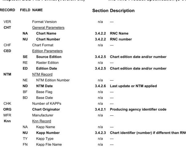
Table 1 - Documentation File Parameters
This table provides a summary of Maptech BSB File Format Documentation File Parameters
(i.e., metadata) with cross-references to applicable sections of IHO S-61 (Product Specification for Raster Navigational Charts).
Maptech BSB File Format (Version 3.0) IHO RNC Product Specification (S-61)
RECORD FIELD NAME Section Description
VER Format Version n/a ---
CHT General Parameters
NA Chart Name 3.4.2.2 RNC Name NU Chart Number 3.4.2.2 RNC number
CHF Chart Format n/a ---
CED Edition Parameters
SE Source Edition 3.4.2.5 Chart edition date and/or number
RE Raster Edition n/a ---
ED Edition Date 3.4.2.5 Chart edition date and/or number
NTM NTM Record
NE NTM Edition Number n/a ---
ND NTM Date 3.4.2.6 Last update or NTM applied
BF Base Flag n/a ---
BD Base Date n/a ---
CHK Number of KAPPs n/a ---
ORG Chart Originator 3.4.2.1 Producing agency identifier code
MFR Manufacturer n/a ---
Knn Knn Record
NA Kapp Name n/a ---
NU Kapp Number 3.4.2.3 Chart identifier (number) if different than RNC
TY Kapp Type n/a ---
Table 2 - Image File Header Parameters
This table provides a summary of image file header parameters with cross-references to
applicable sections of IHO S-61 (Product Specification for Raster Navigational Charts).
Maptech BSB File Format (Version 3.0) IHO RNC Product Specification (S-61)
RECORD FIELD NAME Section Description
VER Format Version n/a ---
CRR Copyright Record n/a ---
BSB General Parameters
NA Chart Name 3.4.2.2 RNC Name NU Chart Number 3.4.2.2 RNC number
RA Image Width Height n/a ---
DU Drawing Units 3.4.2.15 Pixel resolution of the image file
KNP Detailed Parameters
SC Scale 3.4.2.8 Chart scale GD Geodetic Datum Name 3.4.2.11 Horizontal datum
PR Projection Name 3.4.2.10 Projection and associated projection parameters PP Projection Parameter 3.4.2.10 Projection and associated projection parameters PI Projection Interval 3.4.2.10 Projection and associated projection parameters SK Skew Angel 3.4.2.9 Orientation of north
TA Text Angle n/a ---
UN Depth Units 3.4.2.14 Depth and height units SD Sounding Datum 3.4.2.13 Vertical datums
DX X Resolution n/a ---
DY Y Resolution n/a ---
CED Edition Parameters
SE Source Edition 3.4.2.5 Chart edition date and/or chart edition number
RE Raster Edition n/a ---
ED Edition Date 3.4.2.5 Chart edition date and/or chart edition number
NTM NTM Record
NE NTM Edition Number n/a ---
ND NTM Date 3.4.2.6 Last update or NTM applied
BF Base Flag n/a ---
BD Base Date n/a ---
OST Offset Values Section n/a ---
IFM Compression Type n/a ---
RGB Default Color Palette 3.4.2.17.1 Colors used for daytime viewing DAY Day Color Palette 3.4.2.17.1 Colors used for daytime viewing DSK Dusk Color Palette 3.4.2.17.2 Colors used for dusk and nighttime NGT Night Color Palette 3.4.2.17.2 Colors used for dusk and nighttime
Table 2 - Image File Header Parameters (continued)
REF Reference Point Record 3.4.2.16 Mechanism to allow geographical positions to be converted to RNC (pixel) coordinates
CPH Phase Shift Value n/a ---
WPX Polynomial L to X n/a ---
PWX Polynomial X to L n/a ---
WPY Polynomial L to Y n/a ---
PWY Polynomial Y to L n/a ---
ERR Error Record n/a ---
PLY Border Polygon Record n/a ---
DTM Datum Shift Record 3.4.2.12 Horizontal datum shift to WGS84
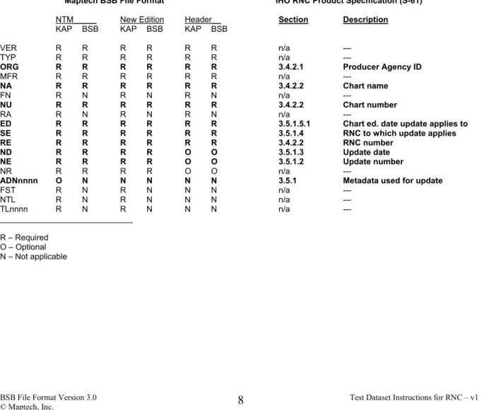
Table 3 - Update Patch File Parameters
This table provides a summary of required update patch file parameters with cross-references
to applicable sections of IHO S-61 (Product Specification for Raster Navigational Chart).
Maptech BSB File Format IHO RNC Product Specification (S-61)
NTM_____ New Edition Header__ Section Description
KAP BSB KAP BSB KAP BSB
VER R R R R R R n/a ---
TYP R R R R R R n/a ---
ORG R R R R R R 3.4.2.1 Producer Agency ID
MFR R R R R R R n/a ---
NA R R R R R R 3.4.2.2 Chart name
FN R N R N R N n/a ---
NU R R R R R R 3.4.2.2 Chart number
RA R N R N R N n/a ---
ED R R R R R R 3.5.1.5.1 Chart ed. date update applies to SE R R R R R R 3.5.1.4 RNC to which update applies RE R R R R R R 3.4.2.2 RNC number
ND R R R R O O 3.5.1.3 Update date NE R R R R O O 3.5.1.2 Update number
NR R R R R O O n/a ---
ADNnnnn O N N N N N 3.5.1 Metadata used for update
FST R N R N N N n/a --- NTL R N R N N N n/a --- TLnnnn R N R N N N n/a --- _____________________________ R – Required O – Optional N – Not applicable
5. Verification and Testing Procedures
In order to verify the proper use of Maptech BSB File Format data as a Raster Navigational Chart (RNC) in conjunction with the Raster Chart Display System (RCDS) mode of operation for ECDIS, there are a number of checks and verification procedures that should be performed. Some are specific to the data itself (e.g., documentation and image files) while others pertain to the overall functionality of the RCDS mode of operation in ECDIS (means/process of updating an RNC in ECDIS).
Specific checks/verifications listed in Sections 5.1 – 5. 4 pertain to the required parameters of an RNC. These are listed in Section 4 (Tables 1, 2, and 3). All checks and verification procedures
require the use of the BSB File Format RNC Test Dataset (see Appendix 1).
Additional tests associated with the overall functionality of RNC data when used in the RCDS mode of operation in ECDIS are contained in IEC Publication 61174, Annex H. Specifically, in Section 17 of Annex H lists the “Methods of Testing and Required Test Results” for the RCDS mode of operation.
5.1 Documentation File Parameters
Using the Maptech Raster Navigational Chart (RNC) Test Dataset, confirm that the chart metadata values are as listed below:
Record/Field Name RNC Test Dataset value
VER Format Version (number) 3.0
CHT General Chart Parameters --
NA Chart Name (same as paper chart) CHESAPEAKE BAY ENTRANCE
NU Chart Number (same as paper chart) 558
CHF Chart Format Coastal
CED Chart Edition Parameters --
SE Source Edition 70 RE Raster Edition 01 ED Edition Date 09/12/1998 NTM NTM Record -- NE NTM Edition Number 70.00 ND NTM Date 10/30/99 BF Base Flag on BD Base Date 10/26/99 CHK Number of KAPPs 1;558
ORG Producing Agency identifier code USA-NOAA/NOS
MFR Manufacturer (of the RNC) MAPTECH
5.2 Image File Parameters
The following parameters should be checked and verified:
Record/Field Name RNC Test Dataset values
VER Format Version
CRR Copyright 2001, Maptech, Inc. All Rights Reserved
BSB General Parameters --
NA Chart Name (same as paper chart) CHESAPEAK BAY ENTRANCE
NU Chart Number (same as paper chart) 558
RA Image Width Height 11547, 9767
DU Drawing Units 254
KNP Detailed Chart Parameters --
SC Scale 1:80,000
GD Geodetic Datum NAD83
PR Projection MERCATOR
PP Projection Parameter 37.083
PI Projection Interval 10.00
SK Skew Angle 0.0
TA Text Angle 90.00
UN Depth Units FEET
SD Sounding Datum MEAN LOWER LOW WATER
DX X Resolution 8.00
DY Y Resolution 8.00
CED Chart Edition Parameters --
SE Paper Chart Source Edition 70
RE Raster Chart Image Edition 01
ED Paper Chart Edition Date 09/12/1998
NTM NTM Record --
NE NTM Edition 70.00
ND NTM Date 10/30/99
BF Base Flag on
BD ADN Record 10/26/99
OST Offset Values Section 1
IFM Compression Type 4
RGB Default Color Palette see “.pdf” file in Test Dataset
DAY Day Color Palette see “.pdf” file in Test Dataset
DSK Dusk Color Palette see “.pdf” file in Test Dataset
NGT Night Color Palette see “.pdf” file in Test Dataset
NGR Night Red Color Palette see “.pdf” file in Test Dataset
REF Reference Point Record [see Image File Printout]
CPH Phase Shift Value 0
WPX Polynomial L to X [see Image File Printout]
PWX Polynomial X to L [see Image File Printout]
WPY Polynomial L to Y [see Image File Printout]
PWY Polynomial Y to L [see Image File Printout]
ERR Error Record [see Image File Printout]
2 3 1 4 1. 36° 48’ 48’’ N / 76° 27’ 00’’ W 2. 37° 24’ 53’’ N / 76° 27’ 00’’ W 3. 37° 24’ 53’’ N / 75° 29’ 00’’ W 4. 36° 48’ 48’’ N / 75° 29’ 00’’ W
5.3 Update Patch File Parameters
For the following parameters, check that the correct values are shown:
VER Version Number 3.0
MFR Manufacturer MAPTECH
ORG Producer Agency ID USA-NOAA/NOS
NA Chart Name (same as paper chart) CHESAPEAKE BAY ENTRANCE
NU Chart Number (same as paper chart) 12221
ED Update applies to chart edition 09/12/1998
SE Update applies to the RNC number 70
RE RNC number 01
ND correct update numbers are shown 08/05/2000
NR correct update numbers are shown 01
ADNnnn required metadata is provided. [see Patch Update Printout]
5.4 RNC Geo-referencing Verification
The following procedures should be performed to verify that the software is correctly handling
the georeferencing supplied in the BSB File Format “.KAP file”. Using chart 12221_1.KAP in
the Maptech Raster Navigational Chart (RNC) Test Dataset, perform the following checks:
1. Open the Maptech RNC test file 12221_1.KAP
2. Set File/Preference to “Local” datum display mode.
3. Pan to the upper left corner of the RNC. Locate the intersection of 37° 20’ 00’’ N -
76° 20’ 00’’ W.
4. With cursor located at intersection confirm that the software displays a Latitude of 37° 20’
00’’ N - 76° 20’ 00’’ W.
5. Pan to the upper right corner of the RNC and locate the intersection of 37° 20’ 00’’ N - 75°
30’ 00’’ W.
6. With cursor located at intersection confirm that the software displays a Latitude of 37° 20’
00’’ N - 75° 30’ 00’’ W.
7. Pan to the lower right corner of the RNC. Locate the intersection of 36° 50’ 00’’ N - 75° 30’
00’’ W.
8. With cursor located at intersection, confirm that the software displays a 36° 50’ 00’’ N - 75°
30’ 00’’ W
9. Pan to the lower left corner of the RNC and locate the intersection of 36° 50’ 00’’ N -
76° 20’ 00’’ W.
10.With cursor located at intersection confirm that the software displays 36° 50’ 00’’ N - 76°
20’ 00’’ W
11.Pan towards the center of the RNC and locate theChesapeake Bay Bridge-Tunnel. Locate
the opening between Trestle B and Trestle C.
12.With cursor located over the base of the R “14” buoy, confirm that the software displays a
6. Reference Documents
In addition to this Test Dataset Instructions document, the following documents should be referred to for detailed information pertaining to the use of Maptech BSB File Format data for RCDS Mode of Operation in ECDIS.
a) BSB File Format Version 3.0, Revision 3.0.7, August 2000
This is the main document that fully describes the BSB File Format, and how it is used to store raster image data and associated textual documentation. The document is available on request from Maptech (www.maptech.com), but may not be used without prior written consent from Maptech, Inc.
a) IMO Performance Standards for ECDIS
Performance Standards for ECDIS were formally adopted by the International Maritime
Organization (IMO) on 23 November 1995 and issued as IMO Resolution A.817(19). Back-up
arrangements for ECDIS were adopted by IMO as MSC 64(67) in November 1996 and became Appendix 6 to the Performance Standards. The IMO Performance Standards permit National Maritime Safety Administrations to consider ECDIS as the functional equivalent of the charts required by regulation V/20 of the 1974 SOLAS Convention.
Raster Chart Display Systems (RCDS) was adopted by IMO in 1998 (MSC 86(70) and became Appendix 7 to the IMO Performance Standards for ECDIS. As a simplified “mode of operation” for an otherwise IMO-compliant ECDIS, official HO-provided raster data can be used as an interim, optional solution where IHO S-57ed3 ENC data coverage is not available.
However, in order to conform to SOLAS regulations, ECDIS equipment operated in the RCDS mode of operation must be used together with an appropriate folio of up-to-date paper charts. This document is available from IMO (www.imo.org)
b) IHO Data Standards and Display Specifications
In conjunction with the IMO Performance Standards for ECDIS, the International
Hydrographic Organization (IHO) developed technical standards for the digital data format and
display. IHO Special Publication 52 (IHO S-52) is the IHO Specification for Chart Content and
Display of ECDIS. It includes appendices describing the means/process for updating, colour and symbol specifications, and a glossary of ECDIS-related terms. The 4th edition of IHO S-52 was
issued in December 1996. IHO Special Publication 57 (IHO S-57) is the IHO Transfer Standard
for Digital Hydrographic Data that was formally adopted as the official IHO standard at the XIV International Hydrographic Conference, Monaco, 4-15 May 1992. It includes an object catalog, DX-90 format, an ENC Product Specification, and ENC updating profile. The current edition (Edition 3.0) was released in November 1996. Both IHO-57 and S-52 are specified in the IMO Performance Standards for ECDIS.
Product Specification for Raster Navigational Charts RNC) – As stated in Appendix 7 of the IMO Performance Standards, the Raster Navigational Chart (RNC) must conform to IHO standards. The necessary RNC Product Specification was adopted by IHO in October 1998 and
c) IEC Testing Procedures
At the request of IMO, the International Electrotechnical Commission (IEC) published a testing document that describes the operational methods of testing and required test results for an IMO-compliant ECDIS. IEC 61174 was officially published as an International Standard in August 1998, and is the basis for type-approval/certification process for an IMO-compliant ECDIS.
RCDS Mode of Operation – To accommodate testing additional ECDIS requirements (e.g.,
Back-up Arrangements and RCDS), IEC has developed testing procedures for Appendix 7
(RCDS Mode of Operation) of the IMO Performance Standards for ECDIS. These testing
procedures are contained in Annex H (RCDS mode of operations) to IEC Publication 61174, 3rd
Appendix 1
Maptech BSB File Format – RNC Test Dataset
In order to perform the necessary checks, inspections and verification procedures, Maptech has prepared a Raster Navigational Chart (RNC) Test Dataset in the BSB File Format. The Test Dataset has been designed to meet the testing requirements for the RCDS mode of operation as specified in IEC 61174 (Edition 3), Annex H. This Test Dataset has been provided to the International Hydrographic Bureau (IHB) on Monaco, and is available on request from IHO (www.iho.int).
The Maptech BSB File Format – RNC Test Dataset CD-ROM is comprised of six parts: 1. Acrobat Reader 4.05 directory
- installer for Adobe Acrobat Reader 4.05 (ar405eng.exe)
2. Test Dataset Instructions for RNC directory
- copy of Test Dataset Instructions for Maptech BSB File Format when used as a RNC. 3. Bsbchart directory
- BSB File Format data of the NOAA Chart # 12221: Chesapeake Bay Entrance (1:80,000 scale)
4. Example Text Files directory - text files of:
Documentation File (12221_BSB.txt)
Image File (12221_KAP.txt)
Update Patch File (12221_NCE.txt, 12221_NTMBSB.txt)
5. Example Patch Updates directory
- includes example patch updates including:
a) a Patch File Archive (PFA)
b) two (2) Notice to Mariner updates (NTM)
c) a new Chart Edition (NCE)
d) full file replacement (CHT)
6. Print directory
- “.pdf” files of the Chesapeake Bay Entrance paper nautical chart. This includes four (4) chart color palettes:
Note: In order to fully utilize the Maptech BSB File Format Test Dataset Instructions for RNC,
it must be used in conjunction with the Maptech BSB File Format Specification. This
document is provided to licensed, Value-Added Developers (VADs).
For those companies/organizations that are not currently VADs with Maptech, Inc., please contact:
Maptech, Inc.
Attention: Tim Sullivan
10 Industrial Way
Amesbury, MA 01913 USA
(978) 792-1000
____________________ Other Test Data Sets:
Although not directly related to this Test Dataset for RNC, other Maptech BSB File format test datasets are available for testing such items as:
- datum shift handling - multi-hemisphere charts
- crossing the international date line
Those wishing to obtain these other types of test datasets should contact Maptech, Inc. (www.Maptech.com)