Provided by the author(s) and University College Dublin Library in accordance with publisher policies. Please cite the published version when available.
Downloaded 2016-01-10T00:37:06Z
Some rights reserved. For more information, please see the item record link above.
Title
Performance Accuracy Of LowCost Dynamic NonDifferential
GPS on Articulated Trucks
Author(s)
Devlin, Ger; McDonnell, Kevin; Ward, Shane
Publication
Date
2007
Publication
information
Applied Engineering in Agriculture, 23 (3): 273-279
Publisher
American Society of Agricultural and Biological Engineers
This item's
record/more
information
http://hdl.handle.net/10197/6070
P
ERFORMANCE
A
CCURACY
OF
L
OW‐
C
OST
D
YNAMIC
N
ON‐
D
IFFERENTIAL
GPS
ON
A
RTICULATED
T
RUCKS
G. J. Devlin, K. P. McDonnell, S. M. Ward
ABSTRACT. The purpose of this study was to evaluate the positional accuracy of dynamic non‐differential global positioning
system (Non DGPS) for tracking articulated trucks across the Irish road network. The study was carried out using a Trimble GeoXT handheld GPS unit in the non‐differential mode. The data was logged through Environmental Systems Research Institute (ESRI) ArcPad software. The GPS unit was operated in conjunction with an external magnetic antenna that was fitted to the cab of the articulated truck. The articulated truck was a DAF 95XF model, 4×2 tractor unit with a Fruehauf manufactured tri‐axle curtain side trailer measuring 13.6 m in length and 4.2 m from the ground.
Routes were traveled from the east of Ireland to the south and southwest of the country on three separate occasions during August 2005 giving a total of six consecutive routes. Over 50 h of data, totaling approximately 6,000 data points, sampled at 30‐s intervals were recorded. Of these 50 h, over 30 h were recorded as dynamic points totaling approximately 4,000 sam‐ pling points. The Horizontal Root Mean Square (HRMS) accuracy was measured at a confidence of 63%. Results ranged from 6.9 m for the Cork 1 route to 3.2 m for the Cork 2 route. With this high level of positional accuracy available, it will be more than adequate to use low‐cost non‐differential GPS to track position and movement of timber trucks across the Irish public road network.
Keywords. GPS, GIS, Non‐differential GPS, Dynamic positional accuracy.
ince the deployment of the first of 24 satellites by the United States Department of Defence (DoD) in 1978, Global Positioning Systems (GPS) have be‐ come a useful tool in forestry management with a need to geo‐reference spatial information in terms of estimat‐ ing forest road surveys (Martin et al., 2001; Holden et al., 2002), extraction of timber logs (Ronnqvist and Westerlund, 1999), transport control of forest fuels (Sikanen et al., 2005), and clarifying GPS performance under forest canopy and on industrial peat bogs (Holden et al., 1999, 2001).
Within the Irish forestry sector (both private plantations and state owned), however, there is a necessity to incorporate Information Technology (IT) into the timber haulage sector (Optilog, 2003). Information technology in this situation im‐ plies the use of GPS for tracking of timber trucks from forest harvesting site to sawmill destination and incorporating this positional technology with Geographical Information Sys‐ tems (GIS) to reference the timber truck on a map, to deter‐ mine if the truck is located at the harvesting site, traveling on a national route or unloading within a sawmill (Frisk and Ronnqvist, 2005).
The rising amount of timber transported on the public road network across Ireland will present major challenges to the Irish road network in the coming years. The potential produc‐ tion of roundwood from the forests of Ireland will reach
Submitted for review in August 2006 as manuscript number PM 6637; approved for publication by the Power & Machinery Division of ASABE in January 2007.
The authors are Ger J. Devlin, Kevin P. McDonnell, and Shane M. Ward, Professor, Biosystems Engineering Department, University Col‐ lege Dublin, Dublin, Ireland. Corresponding author: Ger J. Devlin, Bio‐ systems Engineering Dept., University College Dublin, Earlsfort Terrace, Dublin 2, Ireland; phone: +353‐1‐716‐7418; fax: +353‐1‐475‐2119; e‐‐ mail: [email protected].
5 million m3 per annum by the year 2015 (Coford, 2001). The volume of timber harvested in Coillte (Irish Forestry Board) owned forests has increased from 2.36 million m3 in 1998 to
3 million m3 in 2003. A further increase to 3.25 million m3
was recorded at the end of 2004. The total volume of timber sold in 2003 was 2.66 million m3, which is equivalent to over
1,00,000 truckloads on Irish roads transported from forest site to mill (Coillte, 2003). It is worth noting that there now exists a database of preferred agreed routes that must be trav‐ elled by timber trucks extracting timber from all the desig‐ nated harvesting sites around the country's forests. These routes have been designated by Coillte in conjunction with each local County Council to protect other access routes that are unsuitable and prevent unnecessary road damage. Each route was hand‐picked as the best accessible route for timber extraction based on road width, road strength, and load bear‐ ing capacity. An added advantage of the GPS, once it be‐ comes fully implemented into the timber haulage sector is that 1) timber trucks can be monitored as to whether they are travelling these agreed routes or not and thus enforce any nec‐ essary penalties (such as suspension of the haulage contract) if they are avoiding these agreed routes. 2) The truck can be monitored from the point of view that it is travelling to the correct sawmill destination and not some other destination and removing some of the timber from the load (for personal gain) before continuing on to its proper destination, thus pro‐ viding an added security for the volume of timber trans‐ ported. 3) If the opportunity of a backload arises throughout the working day, then the forest manager can decide which truck is closest to the pick‐up point and divert it accordingly. GPS and GIS technology have already been successfully im‐ plemented and utilized in many fleet management situations such as the effective management of ambulances (Derekena‐ ris et al., 2001), hazardous material truck routing (Frank et al., 2000; Thill et al., 2000), milk collection (Butler et al.,
2 APPLIED ENGINEERINGIN AGRICULTURE 2005) and real‐time multi‐vehicle truckload pick‐up and de‐
livery problems (Yang et al., 2004).
Thus the research is working towards a fully integrated pre‐planning approach to timber haulage in an effort to opti‐ mize routes traveled in terms of 1) haulage costs, 2) distance 3) time, 4) volume of timber transported, and 5) savings from avoidance of empty return journeys and to create and develop flexible and cost‐effective haulage control system for the Irish timber haulage sector.
As part of the overall research effort to fully incorporate GPS and GIS technology into the timber haulage sector in Ire‐ land, an initial study of the performance on the positional ac‐ curacy of non‐differential GPS was carried out on a standard articulated truck travelling across Ireland. The results are presented in this article and show that non‐differential GPS can be both affordable and accurate in its application for the timber haulage industry in Ireland. The rapid development and accuracy of light global positioning equipment offer the potential for cheaper and affordable systems than Differen‐ tial GPS (DGPS) (Prisley and Carruth, 1995; Witte and Wil‐ son, 2004, 2005).
MATERIALS AND METHODS
GPS BACKGROUNDThe Global Positioning System consists of 24 satellites or‐ biting the earth at an altitude of approximately 20,000 km. GPS satellites broadcast radio signals on two different fre‐ quencies, the L1 = 1575.42 MHz and the L2 = 1227.60 MHz. Each signal contains a digital code. The Precise “P” code and the Civilian Access “CA” code. The P code is transmitted on both frequencies but scrambled by the U.S. DoD for security reasons. The P code allows geographical locations to be re‐ corded with sub‐meter accuracy. The CA code is broadcast on the L2 and available to any civilian GPS user. From this one can record factors such as latitude, longitude, altitude, course and speed. The P and CA codes contain timing data that the GPS receiver uses to determine how long it takes the signal to travel from the satellite to the receiver. Since radio signals travel at the speed of light (3 × 10⁸ m/s), the distance between the satellite and the receiver is simply the transmis‐ sion time multiplied by the speed of light. This calculation must be very precise in order to acquire accurate positions. At least three satellites are required to determine a position fix (triangulate the receiver position). Three satellites give an approximate fix but a fourth satellite is required to validate this position fix. Differential GPS is an advanced GPS mea‐ surement that cancels out any errors associated with the tim‐ ing calculations. DGPS involves using a stationary reference GPS receiver at a known location. This base receiver calcu‐ lates the timing corrections of each satellite it is tracking and relays the information back to the GPS receiver. This results in positions that are accurate from about 5 m down to less than 1 m for the C/A code receiver, depending on the actual receiv‐ er being used.
The Trimble GeoXT as used for this experiment is a 12‐channel GPS receiver but was used in the non‐differential mode to determine how accurate raw and dynamic GPS data accuracy could be when fixed on an articulated truck travel‐ ling across Irish roads. The recorded data showed that a maxi‐ mum of nine satellites and a minimum of four satellites were
maintained during recording which implies a confidant level of GPS position fixes (Prisley et al., 1995).
SOFTWAREAND DATA USED
The GIS used in this research is ESRI's Arcview 8.3 (Arc‐ Catalog, ArcToolbox and ArcMap) to explore, query, and analyze the data geographically. The development platform was Windows XP for PC's. The main tools used to create, manage and edit the geodatabase are found in ArcCatalog and ArcMap. ArcCatalog has the tools for creating and modi‐ fying the geodatabase schema while ArcMap is used to ana‐ lyse and edit the contents of the geodatabase.
The Trimble GeoXT handheld provides sub‐meter accura‐ cy. It was used in conjunction with an external magnetic an‐ tenna, which was fitted to the roof of the cab of the truck (fig. 1). The GeoXT handheld includes EVEREST multipath re‐ jection technology for optimal performance in difficult GPS environments. Multipath errors occur when the signal picked up by the GPS antenna has been reflected off a surface, (in this case, the top of the trailer or the wind‐deflector on the roof of the cab) rather than being received directly from the GPS satellite. Because the signal has been delayed, it intro‐ duces errors into the position calculation, therefore reducing the accuracy performance of the GPS. The GPS data was re‐ corded through the ESRI ArcPAD software available on the GeoXT. The data was recorded in the World Geographic Sys‐ tem 1984 (WGS84) i.e. the GPS reference system. Since the digital road map within the GIS is in the Irish National Grid (ING), the GPS data had to be projected into the Irish Nation‐ al Grid reference frame (Ordnance Survey Ireland, 1996, 1999; Bray, 2001). As well as this, WGS84 records the lati‐ tude and longitude in decimal degrees. In order to define the accuracy of the GPS data with the underlying road vector net‐ work in units of meters, each GPS data point was converted from WGS84 decimal degrees to EASTINGS and NORTH‐ INGS of the Irish National Grid in meters. This data conver‐ sion was carried out with Grid Inquest 6.0 software which is available from the Ordnance Survey Ireland web site (Quest Geodetic Software Solutions Ltd, 2005) ). WGS84 is a global system, which implies that data is not defined as precisely as possible on a national or regional basis, therefore a projection onto the Irish National grid was necessary in order to elimi‐ nate alignment and accuracy errors when adding the layers of GPS route data for eventual analysis within the GIS (Ord‐ nance Survey Ireland, 2000, 2001). This projection of
Figure 1. Digital image of articulated DAF XF truck with Fruehauf cur‐ tain‐side trailer and GPS magnetic antenna on the cab of the truck.
co‐ordinate systems was carried out within ArcCatalog. The digital road network of Ireland was used within the GIS. This was comprised of motorway, national primary, national sec‐ ondary, regional, and third class roads. The road network was represented as connections of 5917 nodes and 8941 links. The nodes represent the road intersections and the links represent homogeneous road segments. Geometric networks are built in the GIS model to construct and maintain topological con‐ nectivity.
ARTICULATED TRUCK SPECIFICATIONS
The experimental articulated truck was a DAF 95 XF 4 × 2 tractor unit (two wheels on front axle and four wheels on the back axle. The trailer was a Fruehauf manufactured curtain side trailer with a tri‐axle road‐friendly air suspension, mea‐ suring 13.6 m in length and a height of 4.2 m from the ground.
DATA COLLECTION PROCEDURE AND STUDY AREA
The study area incorporated the truck traveling two main routes across the whole of Ireland, on different occasions throughout the month of August 2005. Each route was trav‐ eled three timesfrom the haulage depot in the east of the country to two destinations in the south and southwest of the country (fig. 2). The GPS was set to record data every thirty seconds along the route. Each route averaged a totalof 1000 sample points but averaging 650 dynamic sample points. There was on average seven satellites acquired for each sam‐ ple point recorded (a maximum of nine satellites and a mini‐ mum of four satellites). Considering that a minimum of four satellites is required to mark a position on earth, this indicates that the GPS antenna remained in continuous strong view of the sky and the orbiting satellites (Prisley and Carruth, 1995). The GeoXT also allows the recorded data to be saved as a sha‐ pefile (.shp), which allowed easy transferring of data be‐ tween GPS and the ESRI Arcview GIS software installed on
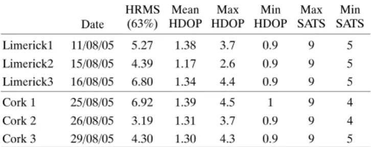
4 APPLIED ENGINEERINGIN AGRICULTURE Table 1. Summary of HRMS positional accuracy for
non‐differential GPS across each of the six routes. Date HRMS (63%) Mean HDOP Max HDOP Min HDOP Max SATS Min SATS Limerick1 11/08/05 5.27 1.38 3.7 0.9 9 5 Limerick2 15/08/05 4.39 1.17 2.6 0.9 9 5 Limerick3 16/08/05 6.80 1.34 4.4 0.9 9 5 Cork 1 25/08/05 6.92 1.39 4.5 1 9 4 Cork 2 26/08/05 3.19 1.31 3.7 0.9 9 4 Cork 3 29/08/05 4.30 1.30 4.3 0.9 9 5
the laptop. Data can be transferred using Microsoft's Active Sync software.. Dilution of precision values are influenced solely by the geometry of the satellites. Low values of Hori‐ zontal Dilution of Precision (HDOP) imply increased accura‐ cy of the recorded data (table 1).
RESULTS AND DISCUSSIONS
MEASURING ACCURACYOver 50 hours of data, totalling approximately 6000 data points were recorded at 30‐s sampling intervals under vary‐ ing open sky weather conditions with the Trimble GeoXT and the magnetic antenna. Of these 50 h, over 30 h were recorded as dynamic points, totalling approximately 4,000 sampling points. The tests were carried out across two separate routes, each route being travelled three different times during Au‐ gust 2005.
The objective of these tests were to determine the dynamic performance of non‐differential GPS in terms of its accuracy with regard to:
S How accurate are the sampled points in terms of their closeness to the underlying road vector network? S Can non‐differential GPS be used successfully and accu‐
rately for logging the position of articulated trucks travel‐ ing across roads in Ireland?
From within the GIS, the data recorded from each route can be added as a shapefile (.shp) layer to the map (fig. 2). The map contains the underlying road network in Irish Na‐ tional Grid (ING) co‐ordinates at a scale of 1;50,000. The GPS points are converted from WGS84 co‐ordinate system in to ING in order to overlay and align with the road network correctly.
Within the tools of the GIS, a spatial join was carried out. This implies calculating how close each recorded GPS point is to the underlying road vector. In order to measure accuracy, it is necessary to have a known location. If there is no known location then precision can only be quantified. In this situa‐ tion, the known location is the road network. The distance of the GPS fix from the known location was calculated. The ac‐ curacy is then expressed as a Root Mean Square (RMS) and is a measure of the spread of data around the known location (i.e.) Horizontal RMS (HRMS). The RMS value represents the accuracy expected 63% of the time.
Another related accuracy specification is 2dRMS or twice the distance RMS. The confidence level for 2dRMS is 95%. A third accuracy specification is Circular Error Probable
(CEP), which has a 50% confidence level. It was decided to use the RMS (63%) as measure of the positional accuracy for these tests.
Figures 3 and 4 below displays the graphs of Distance Vs Data points recorded for each of the six routes which reflect the first moment of distribution. In terms of determining GPS accuracy, this implies a high level of accuracy, acceptable for tracking timber trucks across the Irish road network (Prisley and Carruth, 1995; Ronnqvist and Westerlund, 1999).
Table 1 and figure 5 show that the results of the accuracy of dynamic non‐differential GPS prove quite favorable, with a minimum HRMS accuracy of 6.9 m for the Cork 1 route and a maximum HRMS accuracy of 3.2 m for the Cork 2 route. Considering that 1) the width of the truck is approximately 2.5 m; 2) the total length of the truck and trailer is approxi‐ mately 16.75 m; 3) the lane widths of a motorway are 3.5 m with 2.5‐m wide hard shoulders; and 4) the center median is a minimum of 4.0 m. The same dimensions apply for dual carriageways. Single lane roads have a total range width from approximately 5 to 8 m (National Roads Authority, 2007). These road lane widths for Irish roads implies a very high lev‐ el of accuracy for the Trimble GeoXT GPS with magnetic an‐ tenna in that a glance at a GIS map would show not only a clear position of the truck, or whether the truck is traveling on one side of the motorway/dual carriageway or the other side since the most inaccurate measurement of positional ac‐ curacy is still an impressive 6.9 m. In terms of the single lane roads, the GPS will be recorded in the moving direction, hence there still being no confusion as to where the truck is located without the need for more expensive differential GPS.
DOPS (DILUTION OF PRECISION)
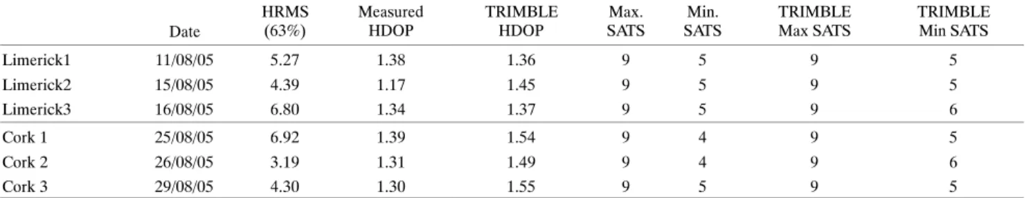
Dilution of Precision (DOP) is probably the most common indicator used as an acceptable measure of positional accura‐ cy and most GPS receivers would record these values today. The DOP (2‐D) values are indicators of the quality of the GPS position. It takes into account each of the satellite's loca‐ tion relative to the other satellites in the constellation and their geometry in relation to the GPS receiver. A low DOP value indicates a higher probability of accuracy. A higher DOP indicates poor satellite geometry and a potentially less accurate recorded position than a lower DOP. There are sev‐ eral expressions of DOP, including HDOP – horizontal DOP, TDOP – time DOP, VDOP – vertical DOP and PDOP – posi‐ tion DOP. By only recording GPS positions with a low DOP implies more accurate GPS recorded positions. The HDOP values for this study were recorded for each of the routes are summarized in table 1 and correspond with those predicted from Trimble's satellite almanac `Mission Planning soft‐ ware' for each separate recording date (Trimble Mission Planning Software; table 2 and fig. 6). There was on average seven satellites acquired for each sample point recorded. Considering that a minimum of four satellites is required to mark a position (3‐D) on earth, this indicates that the GPS an‐ tenna remained in continuous strong view of the sky and the orbiting satellites (Prisley and Carruth, 1995).
Limerick 1 0.00 10.00 20.00 30.00 40.00 50.00 60.00 1 41 81 121 161 201 241 281 321 361 401 441 481 521 561 601 Data points Distance (m) Limerick 2 0.00 10.00 20.00 30.00 40.00 50.00 60.00 1 31 61 91 121 151 181 21 1 241 271 301 331 361 391 421 451 Data points Distance (m) Limerick 3 0.00 10.00 20.00 30.00 40.00 50.00 1 41 81 121 161 201 241 281 321 361 401 441 481 521 561 601 Data points Distance (m)
Figure 3. Distance vs. data points recorded for each of the three routes traveled to Limerick.
The poorest performance of accuracy at 6.8 m for Limer‐ ick 3 and 6.9 m for Cork 1 may be due to increased multipath effects. It was noted on these two days that there was a change of trailer with an increase in height of approximately 0.20 m from the fifth wheel of the truck to the roof of the trailer. This implies that the trailer could have an increased shadow effect (possible obstruction to the line of sight) on the magnetic an‐ tenna, thus leading to possible increased multipath effects and a corresponding reduction in horizontal positional accu‐ racy. The magnetic antenna was not re‐positioned according‐ ly in an attempt to clarify if such a change of trailer would influence the results. From table 1, it can be seen that the re‐ sults did in fact reduce in accuracy, but still remain within ac‐ ceptable limits for non‐differential GPS (Witte and Wilson, 2004, 2005).
CONCLUSION
The results of this study have shown that dynamic non‐dif‐ ferential GPS can be successfully implemented to track posi‐ tion and movement of an articulated truck across the Irish public road network. The level of positional accuracy
(HRMS 63%) ranged from 6.92 m for route Cork 1 to 3.2 m for route Cork 2. This high level of positional accuracy eliminates the need for differential GPS for tracking trucks. Following on from this, GIS and GPS can be used in conjunc‐ tion with the annual designation of timber harvesting sites that are predicted until 2015 in the report published by Co‐ ford. The technology can monitor the movement of the trucks on the preferred agreed routes for timber extraction and im‐ pose any penalties if these routes are not followed according‐ ly. Security of the timber can be increased by tracking the exact movement of the truck from harvesting site to destina‐ tion mill and determine any unacceptable stops in terms of timber removal for personal gain. Back‐loading of trucks can be implemented more efficiently by determining which truck is closest to the pick‐up point and thus divert it accordingly. In an environment where operating costs are rising continu‐ ously, the timber haulage sector must implement the existing technology in order to remain competitive and maximize the time a truck is travelling while loaded. Within the Irish forest‐ ry sector attempts are in progress to fully optimize the trans‐ portation of timber from forest harvesting site to sawmill based on route planning and destination planning
6 APPLIED ENGINEERINGIN AGRICULTURE Cork 1 0.00 10.00 20.00 30.00 40.00 50.00 1 55 109 163 217 271 325 379 433 487 541 595 649 703 757 81 1 Data points Distance (m) Cork 2 0.00 5.00 10.00 15.00 20.00 25.00 30.00 1 55 109 163 217 271 325 379 433 487 541 595 649 703 757 81 1 Data points Distance (m) Cork 3 0.00 10.00 20.00 30.00 40.00 50.00 1 25 49 73 97 121 145 169 193 217 241 265 289 313 337 361 Data points Distance (m)
Figure 4. Distance vs. data pts recorded for each of the three routes traveled to Cork.
incorporating GIS and GPS technology. The cost of a basic in‐vehicle tracking service is approximately 70 euros per truck per month. This includes access to Web‐based raster road maps and even daily driver reports but the maps cannot be interacted with. The only limitations possible are the limi‐ tations of the satellite positional system. With the develop‐ ment of Galileo and possible use of EGNOS at our disposal, the accuracy performance can only get better in the future.
Graph of HRMS and Mean, Max, Min HDOP Vs Routes
0.00 1.00 2.00 3.00 4.00 5.00 6.00 7.00 8.00
Limerick1Limerick2Limerick3Cork 1 Cork 2 Cork 3
Routes Distance (m) HRMS (63%) MEAN HDOP MAX HDOP MIN HDOP
Figure 5. Graph of HRMS (63%), Mean HDOP, Max HDOP, and Min HDOP vs. Route.
The Irish forest industry is moving ever closer to a fully op‐ erational IT infrastructure. It is following the impressive ex‐ ample of Sweden's forest industry. It is just a question of time and implementing the technology that already exists. The eventual plan would be to create a fully integrated data trans‐ fer and IT system to find the best solution i.e. one that offers 1) lowest possible haulage costs, 2) savings from avoidance of empty return journeys, 3) mean haulage distances, 4) per‐ centage of empty return journeys, 5) percentage of return loads, and 6) volume of timber carried. Timber haulage
ÓÓ ÓÓ ÓÓ Ó Ó Ó Ó Ó Ó Ó Ó Ó Ó Ó ÓÓ ÓÓ ÓÓ
Measured HDOP Vs Trimble Planning HDOP
0.00 0.50 1.00 1.50 2.00
Limerick1Limerick3Cork 2
HDOP ÓÓ ÓÓ MEASURED MEAN HDOP TRIMBLE MEAN HDOP
Figure 6. Graph of measured HDOP vs. Trimble Planning Software HDOP.
Table 2. Summary of mean measured HDOP vs. Trimble Planning software mean HDOP values. Date HRMS (63%) Measured HDOP TRIMBLE HDOP Max. SATS Min. SATS TRIMBLE Max SATS TRIMBLE Min SATS Limerick1 11/08/05 5.27 1.38 1.36 9 5 9 5 Limerick2 15/08/05 4.39 1.17 1.45 9 5 9 5 Limerick3 16/08/05 6.80 1.34 1.37 9 5 9 6 Cork 1 25/08/05 6.92 1.39 1.54 9 4 9 5 Cork 2 26/08/05 3.19 1.31 1.49 9 4 9 6 Cork 3 29/08/05 4.30 1.30 1.55 9 5 9 5
can therefore be pre‐planned either tactically (1 to 3 weeks) or operationally (1 to 2 days) and focus these aspects for an overall increased efficiency within the Irish timber haulage sector.
ACKNOWLEDGEMENTS.
Thanks to the Urban Institute Ireland for the use of the Trimble GeoXT GPS equipment.
REFERENCES
Bray, C. 2001. Co‐ordinating Positioning strategy (Information pa‐ per). Ordnance Survey Ireland. Available at www.osi.ie. Butler, M., P. Herlihy, and P. B. Keenan. 2005. Integrating informa‐
tion technology and operational research in the management of milk collection. Journal of Food Engineering 70(3) 341‐349. Coford. 2001. Forecast of Roundwood Production from the Forests
of Ireland 2001‐2015.
Coillte (Irish Forestry Board). 2003. Annual Report.
Derekenaris, G., J. Garofalakis, C. Makris, J. Prentzas, S. Sioutas, and A. Tsakalidis. 2001. Integrating GIS, GPS and GSM technologies for the effective management of ambulances. Com‐ puters, Environment and Urban Systems (25): 267‐278. Frank, W. C., J.‐C. Thill, and R. Batta. 2000. Spatial decision sup‐
port for hazardous material truck routing. Transportation Re‐ search Part C (8): 337‐359.
Frisk, M., and M. Ronnqvist. 2005. FlowOpt – a means of optimis‐ ing wood flow logistics. Skogforsk, Sweden Forestry Research Institute, Resultat no. 5.
Holden, N. M., A. Comparetti, S. M. Ward, and E. A. McGovern. 1999. Accuracy assessment and position correction of low‐cost non‐differential GPS as applied on an industrial peat bog. Com‐ puters and Electronics in Agriculture (24): 119‐130.
Holden, N. M., A. A. Martin, P. M. O. Owende, and S. M. Ward. 2001. A method for relating GPS performance to forest canopy.
International Journal of Forest Engineering 12(2): 51‐56. Holden, N. M., F. Criado Delgado, P. M. O. Owende, and S. M.
Ward. 2002. Performance of a differential GPS in dynamic mode under sitka spruce canopies. International Journal of Forest En‐ gineering 13(1): 7‐14.
Martin, A. A., N. M. Holden, P. M. O. Owende, and S. M. Ward. 2001. The effects of peripheral canopy on DGPS performance on forest roads. Journal of Forest Engineering 12(1): 71‐79.
National Roads Authority (NRA). 2005. Available at: www.nra.ie. Optilog, 2003. An efficiency analysis of the sale, purchase, harvest‐
ing and haulage of timber in the Irish Forestry Sector. Ireland. Irish Timber Council and Coillte.
Ordnance Survey Ireland. 1996. A description of the co‐ordinate reference system used in Ireland (Information paper). Available at: www.osi.ie.
Ordnance Survey Ireland. 1999. Making maps compatible with GPS – Transformations between the Irish grid and the GPS co‐‐ ordinate reference frame (Information paper). Available at: www.osi.ie.
Ordnance Survey Ireland. 2000. A new co‐ordinate system for Ire‐ land (Information paper). Available at: www.osi.ie.
Ordnance Survey Ireland. 2001. New map projections for Ireland (Consultation paper). Available at: www.osi.ie.
Prisley, S. J., and J. S. Carruth. 1995. GPS speeds data collection on GIS road networks. ESRI User Conference. Summerville, S.C. USA. Westvaco Corporation, Timberlands Division.
Quest Geodetic Software Solutions Ltd. 2005. Grid InQuest user manual version 6.0. Published by Quest Software Solutions. Available at www.osi.ie
Ronnqvist, M., and A. Westerlund. 1999. Extraction of logs in for‐ estry using operations research and geographical information systems. Proceedings of the 32ndHawaii International Confer‐
ence on System Sciences Vol 6. Washington D.C.: IEEE Com‐ puter Society.
Sikanen, L.., A. Asikainen, and M. Lehikoinen. 2005. Transport control of forest fuels by fleet manager, mobile terminals and GPS. Biomass and Bioenergy (28): 183‐191.
Thill, J.‐C. 2000. Geographic information systems for transportation in perspective. Transportation Research Part C (8): 3‐12. Trimble Mission Planning software. Available at:
www.trimble.com. Accessed September 2005.
Witte, T. H., and A. M. Wilson. 2004. Accuracy of non‐differential GPS for the determination of speed over ground. Journal of Bio‐ mechanics (37): 1891‐1898.
Witte, T. H., and A. M. Wilson. 2005. Accuracy of WAAS‐enabled GPS for the determination of speed over ground. Journal of Bio‐ mechanics (38): 1717‐1722.
Yang, J., P. Jaillet, and H. Mahmassani. 2004. Real‐time multi‐ve‐ hicle truckload pick‐up and delivery problems. Transportation Science 38(2): 135‐148.