2018 International Conference on Physics, Computing and Mathematical Modeling (PCMM 2018) ISBN: 978-1-60595-549-0
Research on Rapid Registration of Mass Point Clouds via Feature Points
Wen-lai JI
1, Yin-tao SHI
1,*Gang ZHAO
2and Yi XU
21School of Geomatics Science and Technology, Nanjing Tech University, 30 South Puzhu Road,
211800 Nanjing, China
2Department of Hydraulic Engineering Detection, Jiangsu Provincial Hydraulic Research Institute,
97 Nanhu Road, 210017 Nanjing, China
*Corresponding author
Keywords: Point clouds, Registration, Feature points, Information quantity.
Abstract. There exist the problems of low execution efficiency and easy to noise interference when
directly apply the registration algorithm on the registrations of multi-site point clouds. We extracted the feature points from the collected point clouds with the information quantity, applied them on the ICP algorithm to solving the transformation parameters, and completed the point clouds registration with the solved transformation parameters. The proposed method would not only effectively improve the efficiency of point clouds registration, but also greatly enhance the robustness of registration.
Introduction
Due to the limitation of the view of ground-based LiDAR (Light Detection And Ranging) and the need of practical application, in order to obtain the complete 3D data of an object, multi-station multi-angle scanning must be performed. However, each scan data is in the current coordinate system whose origin is on the position of the survey station, therefore we need to convert all station data into a unified system, which is the problem of point clouds registration [1]. Point clouds registration is the first step after the point clouds data acquisition work, is also the foundation of all subsequent processing, data registration accuracy will directly affect the precision of 3D modeling, as a result, the data registration problem is particularly important in the point clouds data processing, it is also one of the core of the point clouds data processing technology.
Definition of Point Clouds Registration
Point clouds registration is similar to the actual mathematical mapping problem, namely to find the corresponding relation of two point clouds data sets, which will be a scan station coordinates of point clouds data conversion to another station coordinates. For the point clouds collected by the ground laser scanning system, there is no distortion in the process of registration and scaling, only 3D rotation and translation of a rigid body transformation, so the registration process can be achieved by spatial similarity transformation.
Let 𝐴, 𝐵 be two point clouds collected in different station, 𝑃𝑖(𝑋, 𝑌, 𝑍) ∈ 𝐴, 𝑄𝑖(𝑥, 𝑦, 𝑧) ∈ 𝐵, and 𝑃𝑖,
𝑄𝑖 be the point sets of the same object surface under different coordinate system. Strictly speaking, point clouds registration is to make all the point pairs (𝑃𝑖, 𝑄𝑖) representing the same point of the object surface from the two point sets meet the same rigid body transformation Eq.1.
Where R is rotation matrix; T is translation matrix; 𝜑, 𝜔, 𝜅are the rotation angle along the coordinate axis X, Y and Z; 𝑡𝑥, 𝑡𝑦, 𝑡𝑧are the displacement along the coordinate axis X, Y and Z. The transform parameters of the homonymy points can be calculated by the Eq.1 and used to register the point clouds from different survey stations.
In general, the point clouds registration process is mainly divided into two steps: one is to find the corresponding points, and the other is to solve the transformation parameters. First, the homonymy points are determined, and the rotation matrix R and translation matrix T are solved.
setting of the laser scanner, the scanning distance between the scanner and the object, and so on. Therefore, the determination of the homonymy points is one of the key points and difficulties in point clouds registration. After determining the homonymy points, it is necessary to determine the registration objective function and solve the transformation parameters quickly and accurately.
[ 𝑋 𝑌 𝑍
] = 𝑅(𝜑, 𝜔, 𝜅) [ 𝑥 𝑦 𝑧
] + 𝑇 (1)
{
R(φ,ω,κ) = [
cosφ −sinφ 0 sinφ cosφ 0
0 0 1
] [
cosω 0 sinω
0 1 0
−sinω 0 cosω
] [
1 0 0
0 cosκ −sinκ
0 sinκ cosκ
]
T = [ tx ty tz
]
(2)
Registration Based on the Feature Points of Point Clouds
Construction of Spatial Index Structure
With regard to point clouds, 3D coordinates are their basic data and direct carriers of containing space information, so various operation involving space relationship features often need matching queries of 3D points coordinates, such as data compression, spatial interpolation, surface reconstruction, etc. For 3D massive point clouds, the efficiency of the matching queries becomes its important restricted factors of fast process [2]. In this paper, we adopt a kind of hybrid tree combining improved octree and kd-tree to construct a dual index system for the massive point clouds, and the treatment scheme is as follows.
(1) We firstly obtain the minimum bounding box according to the point clouds, and set subdivision level and leaf node size of the octree.
(2) We secondly recursively partition the 3D space based on the preset parameters and storage node information with the help of the improved octree.
(3) For the fully split leaf node of that octree, we apply kd-tree on each cell for further division. Each node respectively stored coordinates and index information of this node, and simultaneously the kd-tree pointer address is stored in the leaf nodes of the octree.
[image:2.595.74.527.536.677.2](a) (b) (c) (d) (e)
Figure 2. Construction of Spatial Index Structure.
(4) With the help of the location of the leaf node of the octree, we implement further retrieval in the certain kd-tree that leaf node only determined. It is worth noting that, if we need the neighborhood search of the point clouds and the leaf node number does not meet the conditions, we need expand the range to 8 nodes in its neighborhood to continue until meet the conditions so far.
point clouds collected from different perspectives, and (c), (e) are their spatial index structure constructed by our method.
Estimation of Normal Vector
Normal vector is the most basic geometric quantity in computer graphics. The accurate estimation of normal vector will directly affect the results of point clouds processing such as reconstruction, segmentation, simplification and feature extraction of subsequent surfaces. 3D laser scanning cannot directly obtain the vector information of the point clouds, so how to estimate the normal vector becomes an indispensable step in the data preprocessing of the point clouds [3-5].
In this paper, we use the least square plane method to estimate the normal vector of the measuring points. When estimating the normal information of measuring point P by using the least squares plane method, we will not directly use the measuring point P to fit the least squares plane, but by means of the points among the k nearest neighborhood of P, and consider the normal vector of the fitted plane as the one of P.
Let 𝑁𝑝𝑘 be k nearest neighborhood of Pi, we construct its covariance matrix to gain the normal vector of 𝑃̅.
P ̅ =1
k∑ Pi
k
i=1 (3) Where 𝑃𝑖 ∈ 𝑁𝑝𝑘, and its covariance matrix is as follows.
C = [ P1− P̅
⋮ Pk− P̅
]
T
[ P1− P̅
⋮ Pk− P̅
] (4)
Where 𝐶 is Symmetric positive semi definite matrix, and contains three eigenvalues
𝜆1, 𝜆2, 𝜆3(𝜆1 < 𝜆2 < 𝜆3); 𝛼1, 𝛼2, 𝛼3 are the eigenvectors corresponding to three eigenvalues, in which 𝛼1 represents a normal vector of a plane constructed by 𝛼2 and 𝛼3. The eigenvector corresponding to the minimum eigenvalue is the normal vector of this point, that is, the normal vector of the measuring point Pi is obtained.
Extraction of Feature Points
In order to fully retain detailed features of the object, we regularly collected the point clouds by the means of oversampling, which inevitably introduce “redundancy”. The redundancies here refer to the points those provide a small amount of geometric information for the object model. Based on the information of the point clouds, we can eliminate redundancies and only preserve points with characteristic information, which is the extraction of the feature points [6].
Assuming that the information content of the measuring point 𝑝𝑖 is 𝑀(𝑝𝑖), which mainly describes the spatial position, local flatness, unit normal vector deviation, non-uniformity change and RGB color difference of 𝑝𝑖 in point clouds.
Let 𝑝𝑗 = 𝑝𝑖+ 𝑑𝑖,𝑗, j1, 2, k is the any point among the k nearest neighbor 𝑁(𝑝𝑖) of 𝑝𝑖, ni, nj are
the corresponding normal vector of 𝑝𝑖, 𝑝𝑗, then the information of the measuring point can be estimated by Eq.5, where 𝑀𝑑(𝑝𝑖), 𝑀𝑝(𝑝𝑖), 𝑀𝑐(𝑝𝑖), 𝑀𝑢(𝑝𝑖), 𝑀𝑐𝑜𝑙𝑜𝑟(𝑝𝑖) respectively refer to the measures of space position between 𝑝𝑖 and its nearest neighbor 𝑁(𝑝𝑖), flatness in the local surface, normal vector deviation, the non-uniformity of the change in the direction of the normal vector and RGB difference, the weight coefficient 𝜆𝑑, 𝜆𝑝, 𝜆𝑐, 𝜆𝑢, 𝜆𝑐𝑜𝑙𝑜𝑟 must be no less than zero and meet
𝜆𝑑 + 𝜆𝑝+ 𝜆𝑐 + 𝜆𝑢 + 𝜆𝑐𝑜𝑙𝑜𝑟 = 1.
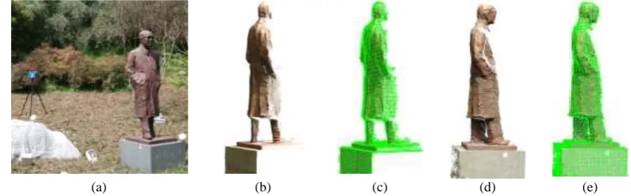
According to the influence of different membership degrees on geometric similarity of surface, we select the different weights to make the geometric similarity between the sampling points present an uncertain level of change. That’s to say, the continuous change state of point clouds is presented between a completely similar and completely dissimilar point. In this way, the point clouds can be simplified as a point set expressed by a number of feature points, thus greatly improving the subsequent registration efficiency. As shown in Fig.3, (a), (c) is the original point clouds of two different perspectives, (b), (d) is their feature points extracted from the information quantity.
[image:4.595.95.482.172.301.2](a) (b) (c) (d)
Figure 3. Extracted feature points.
Registration via Feature Points and ICP
In the automatic registration of point clouds, ICP (Iterative Closest Point) is a widely used method, the basic idea is to focus on each point of the target in the reference point to find a nearest point, the establishment of the mapping relations, coordinate transformation and the optimal calculation by least square method, through iteration until meet the accuracy, and the coordinate transformation is the final synthesis time transform [7-9]. According to this idea, the steps of ICP based the feature points in practical application are as follows:
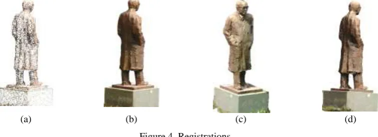
(a) (b) (c) (d)
Figure 4. Registrations.
(1) Assuming that P, Q are the point clouds of the nearby two station; 𝑆𝑃, 𝑆𝑄, are the feature points
sets of P, Q , where SP∈P, SQ∈Q ; 𝛺is the overlapping region between P and Q; pi, qj are the positions of any point in 𝛺 against 𝑆𝑃, 𝑆𝑄. If we indeed to register 𝑆𝑃 and 𝑆𝑄, we need to find out more than three nearest point pairs (𝑝𝑖, 𝑞𝑗).
(2) Calculating the distances between 𝑝𝑖 and 𝑞𝑗among 𝛺, and selecting the shortest point pair as the corresponding point. That’s to say, for every point in Sp, there is a minimum distance from every point in SQ to every point in the overlap area. Then if 𝑆𝑃 include 𝑖 points, 𝑖such shortest distances exist, and 𝑖shortest distance point pairs (𝑝𝑖, 𝑞𝑗) exist among the point sets 𝛺.
(3) Calculating the parameters R and T of two point sets by using the selected points (𝑝𝑖, 𝑞𝑗). (4) Executing the steps (2) and (3) in a loop to obtain more precise transform parameters R and T until the accuracy requirements is satisfied.
[image:4.595.111.490.428.565.2]According to the extracted feature points, we use ICP to calculate their transformation parameters and apply it to the registration of the original point cloud. As shown in Fig. 4, (a) is the registration effect of feature points for two adjacent stations, (b) is the registration result of two corresponding raw point clouds, (c), (d) are the registration effect of the whole point clouds achieved by our method.
Summary
The registration of multi sites point clouds is an important part of point clouds data processing, and its registration accuracy directly affects the subsequent processing steps. At the same time, because the point clouds data volume is usually larger, and the number of measuring points is often over a million, registration directly using all kinds of registration methods has the characteristics of low registration efficiency and easy to be subjected to noise interference [10-12]. We use ICP algorithm and key feature points of point clouds extracted by the information quantity of cloud points to calculate effective transformation parameters, and apply it on the registrations. This will greatly improve the registration efficiency of point clouds and effectively improve the robustness of registration.
Acknowledgement
This research was financially supported by the research project of Surveying and Geo-information of Jiangsu Province (JSCHKY201624), and the research project of Water Resources of Jiangsu Province (2016015, 2017061).
References
[1]C Dold, C Brenner, Registration of Terrestrial Laser Scanning Data Using Planar Patches and Image Data, International Archives of Photogrammetry & Remote Sensing, 2006, 36: 25-27.
[2]S Gog, M Petri, Optimized succinct data structures for massive data, Software: Practice and Experience, 2014, 44(11):1287-1314.
[3]D Akca, Least Squares 3D Surface Matching, The ISPRS International Archives of The Photogrammetry Remote Sensing & Spatial Information Sciences, 2004, 197-206.
[4]J.J. Jaw, T.Y. Chuang, Feature-based registration of LiDAR point clouds, The International Archives of the Photogrammetry, Remote Sensing and Spatial Information Sciences 2008, 303-308. [5]L.A. Piegl, W. Tiller, Algorithm for finding all k nearest neighbors, Computer-Aided Design, 2002, 34(2):167-172.
[6]M. Pauly, M. Gross, P. Leif, Efficient simplification of point-sampled surfaces, IEEE Conference Visualization, 2002.
[7]P Mavridis, A Andreadis, G Papaioannou, Efficient Sparse ICP, Computer Aided Geometric Design, 2015, 35:16-26.
[8]J Goldfeather, V Interrante, A novel cubic-order algorithm for approximating principal direction vectors, ACM Transactions on Graphics, 2004, 23(1):45-63.
[9]D. OuYang, H.Y. Feng, On the normal vector estimation for point cloud data from smooth surfaces, Computer-Aided Design, 2005, 37(10):1071-1079.
[10]G.J. Paulo, A. Nakano, N.L. Gustavo, et al., Front tracking with moving-least-squares surfaces, Journal of Computational Physics, 2008, 227(22):9643-9669.
[11]L. Zhu, J. Hyyppa, A. Kukko, et al, Photorealistic Building Reconstruction from Mobile Laser Scanning Data, Remote Sensing, 2011, 3(7):1406-1426.