1064 | P a g e
HUMAN TRACING USING LOCATION
BASED SYSTEM
Sumit Gahire
1,Rameshwar Mane
2, Abhay Sharma
3Ravikiran Waghmare
4, Gitanjali Mate
51,2,3,4
Department of IT, SavitribaiPhule Pune University,
Pune (India)
5
Assistant Professor, Department of IT, SavitribaiPhule Pune University,
Pune (India)
ABSTRACT
Crimes are getting worse in today's era, nobody feels safe while travelling or specially to be in abandoned
area. Women facing separation, particularly where there is violence and abuse. We hope this information
will help humans specially women to negotiate safety for themselves and their children. However, we
acknowledge that there needs to be important changes in how domestic violence, child protection and family
law issues are dealt with to improve the safety of women and children. Currently, women face many problems
when escaping domestic violence and child abuse. The research indicates that survivors of violence and
abuse begin recovery when their exposure to danger has stopped and they are able to re-establish safety.
However, since the criminal justice, child protection and family law systems leave women exposed to this
violence and abuse, they are placed in the difficult position of being unable to focus on recovery and safety.
In fact, when mothers are trying to negotiate their own and their children's safety they are put at more risk as
these systems fail to provide a safe environment for this to take place.The project is designed for the human
security especially for the women protection purpose. Usually while travelling, women are facing many issue
related with the safety. So, in order to protect them from the other the smart safety device is created. Switch is
connected to the controller so that whenever a person feels that it is not safe place or the person behind her
disturbing continuously, and then he/she can press the button if they wants so that the message goes to the
nearby police station as well as to the relatives. Hence he/she will find the needed help. GPS is used to detect
the location of person which is he/she carrying and GSM isused to send the location.
Keywords: GPS, GSM, Location, Latitude, Longitude
.I. INTRODUCTION
1065 | P a g e
Arduino-microcontroller is use to invoke the GPS and GSM module. The web portal is provided by the admin. Admin can add and update Police Station details and Person’s details. After Logging in, Admin can see list of all Requests sent from Device. Every request is assigned to nearest Police Station by using the haversine algorithm.II. EXISTING WORK
1066 | P a g e
(MS). RS includes a computer and a GPS receiver with a program to perform the execution and them sends the data to the MS using GSM. The MS could be anywhere within 50km radius of the circle. The MS contains 2 receiver, the 1 receiver is GPS receiver which takes and signifies the position co-ordinate of MS and the 2 receiver is received by GSM modem as SMS and it shows the Differential data (DD). The system can operate with n numbers of mobile station .The system can be more handy if we implement it on a smart-phone rather than using a PC. In paper [5] the author aim to advance the positional accuracy of network based positioning system in severe non-line-of-sight (NLOS) and multipath environments. The operation is done by using a two-step position determination method and a one-step method. The two-step position determination method is split into two step which includes optimization with NLOS mitigation and geometry and motion based adjustment. After this process one-step position determination method is executed in which it offer a position determination scheme which equally handles the two processes in one step. Well ahead conducting the two method it was detected that it is best suited in the conditions where severe NLOS and multipath propagations exist Later it was proved that projected algorithm can improve the positioning accuracy compared to the current algorithms.III. PROBLEM STATEMENT
This System is developed for human safety to reduce the crime in the today’s era. As crimes are getting increase,this device help the person to get the help easily and fast. The nearby police station gets the request of user who is in trouble and accordingly the help is provided to the user.In this system we will include 2 roles namely Admin(Server) and Police Station. Server has the ability to add the police station and users detail as well as Server can modify the details. Each request is then assigned to nearest police station using the haversine algorithm,these request is also send to the server.
IV. HARDWARE
The system uses GPS, GSM and Arduino to track the location of the users.
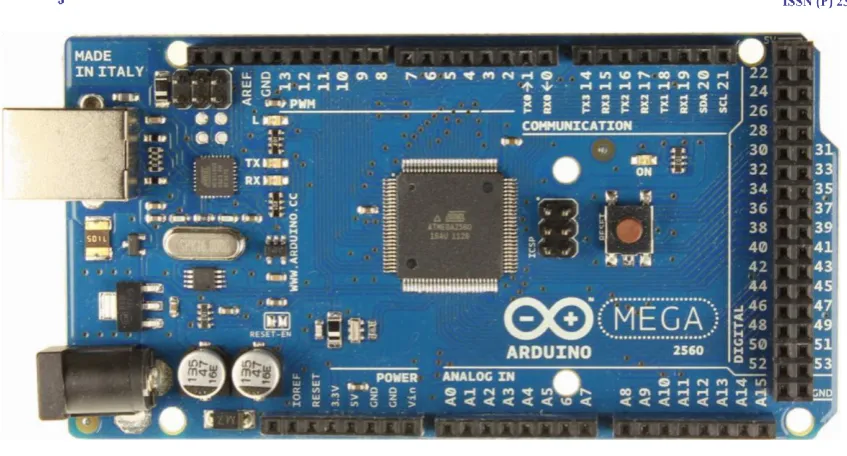
4.1 Arduino
1067 | P a g e
Fig 1. Arduino Device
V. GSM Module
GSM/GPRS module is used to establish communication between a computer and a GSM-GPRS system. Global System for Mobile communication (GSM) is an architecture used for mobile communication in most of the countries. Global Packet Radio Service (GPRS) is an extension of GSM that enables higher data transmission rate. GSM/GPRS module consists of a GSM/GPRS modem assembled together with power supply circuit and communication interfaces (like RS232, USB, etc.) for computer. GSM/GPRS MODEM is a class of wireless MODEM devices that are designed for communication of a computer with the GSM and GPRS network. It requires SIM (Subscriber Identity Module) card just like mobile phones to activate communication with the network. Also they have IMEI (International Mobile Equipment Identity) number similar to mobile phones for their identification.
VI. ALGORITHM
6.1 Haversine Algorithm
The haversine formula determines the great-circle distancebetween two points on a spheregiven theirlongitudesandlatitudes. Important innavigation.
6.2 Haversine formula
For any two points on a sphere, the haversine of thecentral anglebetween them is given by
Where
hav is thehaversinefunction:
1068 | P a g e
• r is the radius of the sphere,• φ1, φ2: latitude of point 1 and latitude of point 2, in radians
• λ1, λ2: longitude of point 1 and longitude of point 2, in radians
On the left side of the equals sign d/r is the central angle, assuming angles are measured inradians.
VII
.
PROPOSED SYSTEM
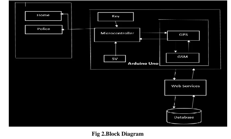
This system is developed for human safety, Day by day the people’s security is becoming the common issue, registering theft, robbery, murders and house breach every year. With the App revolution of smart phones, many security apps are developed every day but even the other side that is fraudulent or adversary knows that such apps do exist, and they are equally smart to confiscate the victim’s phone. In this project System we will include two roles namely Admin (Web Portal) and Police Station (App). Admin can add and update Police Station details and Person’s details. Every request is assigned to nearest Police Station through SMS. List of nearby Requests are sent from Person’s device. Police can see current location from where the request has been made.
Fig 2.Block Diagram
Solve for d by applying the inverse haversine (if available) or by using the arcsin e ( inverse sine) function :
where h is hav( d/r), or more explicitly:
1069 | P a g e
VIII
.
SYSTEM PHASES
7.1 Registration phase
Admin needs to add all the police station details to the server which includes the name of the police station, location, mobile number, police station in charge, username and password. After successfully registration the credential of the police station is provided to the respected police station incharge through SMS or email. Login credential are the soul of the system. The police station in-charge has to login to portal through the web browser.
Fig 3.1 Add Police Station Details
User who has purchased the device gets registered by the admin with the unique id. The user details includes , address , mobile number ,relatives mobile number , email-id. If the user wants to change the relative contact number he/she has to contact the admin to change the mobile number details.
1070 | P a g e
7.2 Processing phase
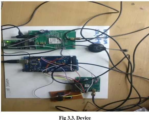
• Whenever the user feels unsafe or in danger he/she press the button to get the help and while pressing the button a beep will be generated.
• After pressing the button the micro-controller gets executed and the GPS attached to the microcontroller gets the location of the user.
• After getting the location details the micro-controller invoke the GSM to send the location to the server.
Fig 3.3. Device
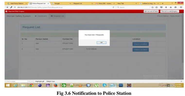
• After receiving the request from the user the system will execute haversine algorithm which will calculate the nearest police station and then sends the request to the nearby police station, admin as well as to the registered relative contact with the link of the location through SMS.
1071 | P a g e
Fig 3.5.Request List at Admin portal
• The Police Station will receive the request in the web browser through a pop-up notification along with a beep
Fig 3.6 Notification to Police Station
• In the browser the police can see the location of the user with the help f google map provided by the admin.
Fig 3.7. Location of Device on Map
1072 | P a g e
The proposed system is very useful for the people who are in trouble. This system help reduce the crimes. In our proposed system the request is sent to the nearby police station so the victim can get help as fast as possible .In the near future this system can be more handy , reliable and more accurate than the existing system.X. FUTURE SCOPE
The main aim of this paper is to provide more safety to the people of this world and reduce the crime as much as possible.
The outlines are given below:
The size of the device can be reduce by using the Nano-technology.
Achieve 100% accuracy in tracing the location of the user.
Include new features such as camera to capture audio or video for evidence.
REFERENCES
[1]IEEE Ravi SekharYarrabothu, BramarambikaThota, “ABHAYA: AN ANDROID APP FOR THE SAFETY OF WOMEN”, IEEE INDICON , 1570191849, 978-1-4673-6540-6/15/$31.00 ©2015 IEEE.
[2]Pradip V Mistary, R H Chile, “Real Time Vehicle Tracking System Based on ARM7 GPS and GSM Technology”, IEEE INDICON 2015
[3]Dr.Velayutham. R, Sabari.M, ErkkiSutinen, SornaRajeswari.M, “An Innovative Approach for Women and Children’s Security Based Location Tracking System “2016 International Conference on Circuit, Power and Computing Technologies [ICCPCT] , 978-1- 5090-1277-0/16/$31.00 ©2016IEEE
[4]Dr. Asaad Al-Hindawi, Majeed Nader, “Performance of Differential GPS Based on a Real-Time Algorithm Using SMS Services of GSM Network” 2012 International Conference on Future Communication Networks, 978-1-4673-0260-9/12 $31.00 © 2012 IEEE
[5]Kegen Yu and ErykDutkiewicz, “Geometry and Motion Based Positioning Algorithms for Mobile Tracking in NLOS Environments”, reviewed at the direction of IEEE Communications Society subject matter experts for publication in the IEEE Globecom 2010 proceedings, 978-1-4244-5638-