Mapping urban accessibility: gamifying the citizens’
experience
Catia Prandi
1,∗, Valentina Nisi
2, Paola Salomoni
1, Nuno Jardim Nunes
2, Marco Roccetti
11Department of Computer Science and Engineering, University of Bologna, Bologna, Italy 2Madeira Interactive Technologies Institute, University of Madeira, Funchal, Madeira, Portugal
Abstract
In this paper wepresent the design process and some interesting fieldtr ialre sultsof tw odifferentgame
applications, designed and developed in order to extend and motivate the community of mPASS. mPASS
is an urban accessibility mapping system that allows citizens to collect reliable data about barriers and facilities via crowdsourcingand crowdsensing andit uses these data tocalculate accessible paths. On the one hand mPASS needs to collect a sufficiently dense, detailed and trustworthy amount of data. On the otherhand, thecommunity interestedin obtaining accessible pathsis notbigenough to reachthe critical massofinformationneededbythesysteminordertoprovideeffective services.Toovercomethisproblem, weinvestigatedgamificationstrategiesi nd esigningtwom obileapplicationst argetingyounga dultswalkers, aimedtoenlargethedatacontributorscommunity.Thedesignprocessandfieldt rialr esultso fb othgames arepresented,highlightingthedesigndecisionsresultedfromfeedbacksessions,focusgroupsandexperience prototyping.
Receivedon04 November 2015;acceptedon 04 November 2015;publishedon 01 December 2015
Keywords: urbanaccessibility,crowdsourcing,crowdsensing,gamification,pervasivegame
Copyright © 2015 C. Prandi et al., licensed to EAI. This is an open access article distributed under the terms ofthe Creative Commons Attribution license (http://creativecommons.org/licenses/by/3.0/), which permits unlimited use,distributionandreproductioninanymediumsolongastheoriginalworkisproperlycited.
doi:10.4108/eai.1-12-2015.150711
1. Introduction
With an increasing number of people living in cities, urban mobility became one of the most important research fields in the so-called smart city environments. In fact, in [1], authors define a smart city as “a city well performing in a forward-looking way in economy, people, governance, mobility, environment, and living, built on the ‘smart’ combination of endowments and activities of self-decisive, independent and aware citizens”. In this context, smart mobility is defined by four factors which reflect the most important aspects about urban mobility: (i) local accessibility; (ii) (inter)national accessibility; (iii) availability of ICT-infrastructure; and (iv) sustainable, innovative and safe transport systems [1]. From these definitions it is clear that smart mobility, and in particular urban accessibility, is a very important element that needs to be tackled in order to improve the quality of life in cities. This is especially relevant for people
∗
Corresponding author. Email:[email protected]
disabilities, mothers with baby strollers or tourists carrying heavy luggage [5]. In order to calculate these personalize paths mPASS needs an updated picture of the accessibility urban elements in the environment [6]. To gather these data mPASS uses georeferenced information collected by users via crowdsourcing and crowdsensing [7].
A key factor for the success of any crowdsourcing system is the recruitment of a sufficiently large group of users to reach critical mass engagement. This is especially hard in mPASS since the main target population (people with disabilities) represents a small group of citizens compared with other communities. In addition, in order to evaluate data trustworthiness our system requires multiple mapping of the same urban element.
These requirements motivated the research issues described in this paper: i) how can mPASS involve and motivate a wide variety of citizens in collecting data about urban accessibility during their daily routines?; ii) how can the system provide a constantly updated picture of the accessibility barriers and facilities in the urban environment?; iii) how can mPASS obtain multiple validation reports that ensure the trustworthiness of data?. All of these research questions suggested gamification as a potentially interesting strategy to adopt. In fact, gamification is the use of game elements and mechanics in order to increase motivation in performing certain tasks [8].
In particular, our intent was to use gamification to enlarge the community of mPASS users by recruiting people that are not directly interested or benefiting from the services provided by our system. We archived this goal by exploiting either intrinsic motivation (entertainment and/or social belonging) or extrinsic motivation (rewards) to engage a different target of citizens to map their surrounding location and report accessibility points such as zebra crossings, stairs, traffic lights, steps, disabled access ramps, etc..
In this paper we describe the concept, the design process and the development of two gamified location-based mobile applications (apps), designed to motivate and involve a wide variety of people in gathering data about urban accessibility. The two gamified apps have been designed expressly to increment the amount of data voluntarily collected and validated by citizens via crowdsourcing and crowdsensing. In particular we deployed two different strategies:
(i) Gamify the mPASS data gathering app, in order to engage people in mapping data exploiting extrin-sic motivation, by means of explicit rewords.
(ii) Develop a georeferenced pervasive game, in order to involve people using intrinsic motivation asso-ciated with curiosity, exploration, spontaneity, interest and fun.
In order to conceive and design the games, we adopted an iterative design process. We started by sketching a number of possible game concepts that would involve citizens in reporting barriers and facilities. Then, we organized sessions of feedback with fellow researchers and students from our institution in order to validate refine and select the best game concepts. Out of several generated game concepts, we selected two to be developed further into experience prototyping sessions. The experience prototyping enabled the understanding of the flow of the game, and the engagement of users. The games experience allowed us to capture improvements and suggestions from the users and it also highlighted practical logistical problems. Moreover, an interesting and unexpected concept emerged from the sessions: users surprisingly noticed their lack of awareness about the surrounding urban environment. After the experience prototype sessions, we developed the resulted two games and we conducted a field trail with a target of young and avid walkers and players, showing interesting results that prove the feasibility of our approach in involving a different community in mapping urban accessibility.
The reminder of this paper is organized as follows. Section2presents background and related work, while Section3briefly introduces the mPASS system. Section 4 presents design of the two gamified apps, from ideation to the experience prototype. The development of both mobile apps and some interesting trial field results are described in Section 5 while Section 6 concludes the paper.
2. Backgroundand related work
Our research draws inspiration from a wide variety of projects focusing on gamification. These include alter-nate reality games, pervasive games, games with a pur-pose (GWAP), serious games, exergames and gameful design. In particular, we have investigated how gamifi-cation concepts can be exploited in crowdsourcing and crowdsensing systems. This section briefly describes the most significant research in these areas, which are related to:
(i) gamification in crowdsourcing systems that can benefit people with special needs;
(ii) crowdsourcing system to collect data in urban accessibility.
2.1. Gamification in crowdsourcing system
impossible to be solved by a computer [9, 10]. The pioneering example was the EPS game [11] develop by von Ahn. Other interesting examples are often related to the annotation and tagging of images, videos or web content with the purpose of improving the accessibility of web pages. For example, in the ESP game the labelling of random web images with keywords is the basis of a simple online two-player game [11]. ESP is one of the first examples of a game with a purpose (GWAP), a game in which people, as a side effect of playing, perform some useful tasks through crowdsourcing [12,13].
Another example is the Phetch game [14] that collects explanatory sentences (instead of keywords) for randomly chosen images. Phetch is a multiplayer game in which a player sees the image and helps other players to guess it giving a textual description of such image. The use of game mechanisms is a very important incentive to engage and motivate the crowd in performing voluntarily tasks of information retrieval [15]. In projects like ESP [11] or Phetch [14], the game is used to motivate and engage people in playing voluntarily, just for their entertainment. The real purpose of these games is hidden in the game mechanism and users don’t need to know it for playing. Some games with a purpose have deep social values. For example HearSay [16] is a non-visual web browser, where users collaboratively and voluntarily assign a label to each web page element using keyboard shortcuts or voice commands. These labels are stored in both local and remote repositories and shared with other users. The Social Accessibility project [17] also operates on a voluntary basis of users. It involves crowd workers to externally modify Web pages adding accessibility metadata in a collaborative environment. Similarly, reCAPTCHA [18] takes advantage of the people efforts in solving CAPTCHAs (Completely Automated Public Turing test to tell Computers and Humans Apart) to help to digitize books and newspapers. The Dotsub platform [19] offers the option
to engage the crowd for captioning video. Instead, the DVX project [20] crowdsources the creation and distribution of amateur video description, allowing sighted video viewers to verbally describe DVD and Internet-based media.
2.2. Crowdsourcing systems to map urban
accessibility
During the past few years, crowdsourcing has been exploited also in several projects related to real-word context [21]. In particular, different projects
exploit accessibility issues. One example is the VizWiz smartphone application [20] where visually impaired people can take a picture using their smartphone, ask a question by speaking to the device, and then
wait for a real-time spoken answers provided by paid workers on Amazon Mechanical Turk [22]. A similar approach is adopted in [23] where workers from Amazon Mechanical Turk have to find, label, and assess sidewalk accessibility problems or bus stop locations and surrounding landmarks in Google Street View imagery.
Several projects were developed with the aim of collaboratively collecting data about the indoor and/or outdoor urban accessibility environment, such as AccessToghether [24] and AXSmap [25]. These tools allow users to collect accessibility information about places and services and display them in a map of the neighbourhood, using a mobile phone or a computer. Another example is Human Access [26], a mobile application that allows users to select a place using Foursquare and then to rate some attributes related with its accessibility. In Wheelmap [27] users can search, find and mark wheelchair-accessible places by the mobile application or the online map. Wheelmap is based on OpenStreetMap [28], a collaborative and free editable map of the world created by users. In [29] the authors describe a platform that exploits crowdsourcing and crowdsensing to map outdoor accessibility elements in the urban environment. Another interesting work allows users to link accessibility annotations to geospatial data in order to compute a personalized route, considering the user’s preferences and needs [30].
3. The mPASS system
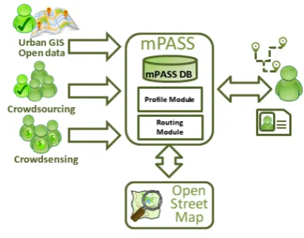
The mPASS system [4,6,7] collects georeferenced data about aPOI (accessible Point of Interest). An aPOI is a accessibility urban barrier and facility or, more generally, a urban characteristics, which are relevant to pedestrians. This information is used in order to provide the community with personalized pedestrian paths, on the basis of preferences and needs expressed by each user.
Figure 1. mPASS system
prevent the user from reaching his/her destination/goal compromising the effectiveness of mPASS services. For example if there is an undetected flight of stair on the path, a wheelchair user could be forced to stop and find an alternative route.
Collected data are provided to users on the basis of a user profile, which describes her/him in terms of barriers and facilities s/he likes, dislikes or wants to avoid. The routing algorithm removes all paths, which include barriers, to avoid and provides one to three possible solutions, where liked and disliked barriers and facility are weighted together with the total lengths of the path. All the solutions are summarized to the user who can select the more appropriate path on the basis of her/his actual preferences. A complete description of mPASS architecture can be found in [4], instead in [6,7] we describe the personalized mobility service.
We evaluated the possible impact of mPASS on a 60 users group (26 female, 34 male), with ages ranged from 19 to 68 (with an average value of 44), including blind people and people with low vision (30), wheelchair users and users with physical impairments (5), deaf and hard of hearing users (1) and elderly people (15). The whole group has stated to be interested in personalized routing services while only the 50% was specifically interested in accessible paths. This research results confirm that only people with specific disabilities are concerned in collecting data related to barriers and facilities in urban environment.
4. Fromideation to experienceprototyping
Drawing on studies on urban mapping crowdsourcing systems and on the role of playful elements placed at the service of our society, we designed three main goals guided our game design concepts:
(i) social belonging focusing on disability;
(ii) location-based entertainment;
(iii) daily health and fitness activities in the urban environment.
We adopted an iterative design process in order to conceive, refine and prototype the games. In this section with describe the outcomes of each phases involved in the design and prototype process, from the ideation by sketching of some game concepts, to the refinement of the most suited games through a series of feedback and experience prototyping sessions, in order to capture users feedback and explore the game flow.
4.1. Ideation
The creative process of generating new game concepts was driven to the main idea to transform the process of collecting and sharing data about urban accessibility into an entertaining task for a wide variety of users, extending the mPASS direct beneficiaries.
We started the process by brainstorming a series of possible urban games to engage a wide variety of walkers in mapping urban elements. We then explored each game concept considering different strategies to validate the sensing activity and the collected urban data. The outcome of the ideation session was the design sketch of three games, designed on the three above mentioned strategies.
A Geo-minesweeper game (based on the traditional minesweeper game) was designed to appeal to people who love walking and with a strong social belonging. In fact, such game would push users to explore the city (the game grid is a area in the city map) and report accessibility barriers (that is the mines) in order to complete an urban path. If the player finds an aPOI and does not report it, he/she loses one game life and will have to start a new round of the game (like in the minesweeper traditional game). Our intent was to enhance feelings about social belonging, using the virtual mine as a metaphor: a mine, like an accessibility barrier for a person with disability, blocks the walker to reach his/her destination.
A third game concept generated was called KidCom! (Short for Kids Competition). This game was designed to stimulate a treasure hunt competition among children. The game involves answering question regarding general knowledge of the city or specific topics set by the teacher. Answering questions unlocks hints for the participants, that will lead them to find a secret place. This game is beneficial for children because by playing, they can improve their feeling of awareness with the urban environment and understand which urban elements can influence (in a positive or negative way) the pedestrian urban mobility.
The fourth game sketched was Geo-Zombie. The goal of the game is to stay alive, avoiding to be eaten by zombies. While trying to do that the user is exploring the surroundings while providing location of aPOI for the mPASS application in order to get weapons and ammunitions to shoot the zombies. We envisaged that such strategy could engage people by exploiting the feeling of positive fear and challenges evoked by the zombies apocalypse.
After conceiving the rules and designing possible scenarios for such games and their users by means of personas and storyboards, we presented the concepts to an audience of researchers and HCI students. We collected their feedback in order to refine and improve the games, before proceeding to a structured focus group.
4.2. Focus group
After ideation we organized an expert focus group in order to: (i) assess the pros and cons of each game strategy in relation to our goals; and (ii) narrow the selection to one or two games, to bring forward to the deployment stage. The focus group was organized at the Madeira Interactive Technologies Institute and lasted around two hours and involved seven participants (all researchers with familiarity with gameplay, game design and interactive technologies). The focus group started with the introduction to the four game concepts through a series of slides. The discussion was open after each game concept presented, taking notes about comments and issues came to notice.
During the focus group the Geo-Zombie and HINT! games emerged out as the most engaging yet feasible ones. The Geo-minesweeper can have the side effects to correlate, in a wrong way, the positive behaviour of mapping accessibility elements with the negative one to mine the city. Moreover, it needs a very accurate GPS localization to avoid inconsistent gameplay. Instead, the game revolving around the children’s competition (KidCom!) was discarded because kids required more motivation than just finding a secret location and it needs people involved in the game coordination and organization (like teachers and parents), making the
game not suited to be played regularly. HINT! was criticized due the issues related to the copyright of the images but was appreciated the idea of using location-based voucher to motivate and engaged users.
We decided then to proceed with the experience prototyping of HINT! and Geo-Zombie, in order to assess if transferring the concept to a physical experience could reveal some unexpected findings.
4.3. Experience Prototyping
Experience prototyping is a technique borrowed from experience design and service design disciplines in order to test an experience or service in physical space and over time [31]. Such prototyping technique helps to refine the concept and the overall design of the experience before any investment is made in implemen-tation details. Experience prototyping can be used in three critical design activities: understanding existing experience, exploring ideas, and communicating design concepts. We made use of the experience prototype to advance the design and understanding if the simulated game flow can motivate the walker in playing (and so, mapping aPOIs). By employing this method we were able to better understand the flow of the experience, the issues encountered by the participants as well as their feedback and desires regarding the game design.
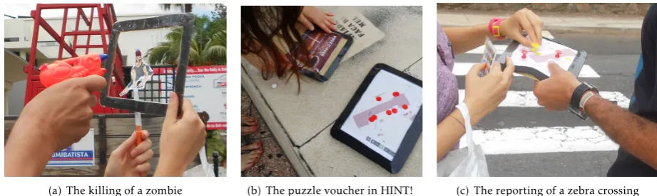
In order to carry out an experience prototyping Geo-Zombie and HINT! we recruited four users who in turns tried both the games. For the Geo-Zombie, we prepared paper wireframes of the phone interface and physical zombies paper puppets to chase the users. To shoot the zombies we used a plastic gun recharge with water (ammunitions), see Fig. 2(a). For the Hint! game we prepared the paper wireframes of the screens and a puzzle final voucher for the players (Fig.2(b)).
Subsequently we defined a series of tasks for the users to execute, and we tagged along them, taking notes and videos while they were playing the games. At the end of the experience a short interview was conducted with each participant. Our participants were all employees (faculty and staff) of the Madeira Interactive Technologies Institute, two female and two male, ranging from 25 to 45 years old, with some experiences in technology and gameplay. In particular, U1 a 45 years old Professor, U2 a 25 year old Master student, U3 a 30 year old PhD student and U4 a 33 year old accounting clerk and administrative manager.
(a) The killing of a zombie (b) The puzzle voucher in HINT! (c) The reporting of a zebra crossing
Figure 2. Pictures related to the experience prototyping
from being confused by paying attention to many different possible types of urban elements. In particular, during the Geo-Zombie experience prototyping, we asked users to report steps and stairs, while during the HINT! game experience prototyping, we asked for zebra crossings (see Fig.2(c)).
4.4. Geo-Zombie experience
From our observations and interviews we can confi-dently affirm that during the experience prototyping of Geo-Zombie all the four users had a lot of fun. Two of them enjoyed the game so much that they continued to play after the task was completed reporting more aPOIs in order to acquire more points and ammuni-tions. Two of the users surprised us by entering in a building as an escape technique to hide from the zombies. That technique was successful for survival and for reaching faster some aPOIs, located close to the building. Another unexpected behaviour of one user was to switch strategy after some gameplay: instead of running away from zombies he preferred to chase them. At the end this user, U1, said:
I found the game become too easy, it needs more zombies.
Such comment made us focus our attention on the number of zombies and on the level of difficulties that different players would enjoy. The same user also reported:
After obtaining the gun, I changed my strategy: I really wanted to kill the zombie but I was still interested in finding zebra crossings because I was not aware that there are so many of them around this place.
Such comment made us realise that being engrossed in the game, may also distract players from reporting aPOIs.
Another consideration of the player U1 regarded the travelling speed of the Zombies.
Maybe different speeds zombies can make the game more exciting
.
All of the Geo-Zombie players were so immerse in the game to incremented their walking speed to escape from the zombie. In some case they even started to run. A player explained:
There was immediately a zombie there, and I had to kill him or I would die. The game made me feel different... excited!
4.5. HINT! experience
The second experience prototyping involved the same four players that had been involved with Geo-Zombie. The players seemed less excited to play HINT! than playing Geo-Zombie. This was somehow expected, since the HINT! game was designed to appeal to a different audience, motivated by the extrinsic motivation (the voucher) instead than by the game itself. The voucher was provided in pieces, making each single piece available to users for each aPOI reported. Getting the pieces of voucher seemed to be a strong motivator for three players out of four (U2, U3 and U4). Nevertheless, U2 was not interested in the voucher and U1 was disappointed by the type of voucher gift he received at the end. He clarified in the interview that it is important for the voucher to be personalized and connected with the user interests. On the other hand, two other players were excited to get some free voucher of any sort. U2 found particularly motivating the idea of using a voucher and confirmed:
I prefer playing HINT!. It was kind of easy to do, without someone that was trying to catch me... and I like the voucher thing. Geo-Zombie was too much “of a game” to have in my daily routine.
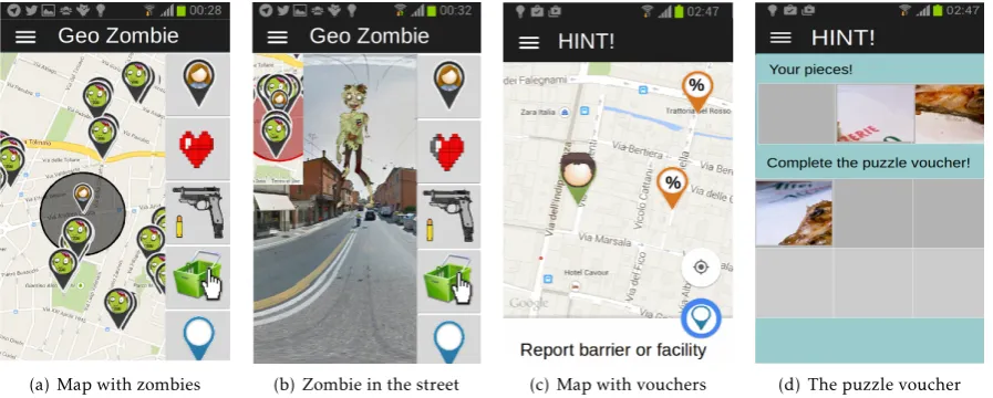
(a) Map with zombies (b) Zombie in the street (c) Map with vouchers (d) The puzzle voucher
Figure 3. Screenshot of the developed prototype of Geo-Zombie and HINT!
I felt very motivated about reporting aPOIs just for the interest I had in exploring the area and discovering them. It is the space that I had around for ten years and I was surprised about how many zebra crossings there are besides zebra crossings are so big so I cannot imagine to look for another things!
U4 highlighted a similar thought:
Mapping in itself it is a strong motivation, more than the gameplay, because people become more aware about the space they are surrounded by and it is very important.
A final important finding was the importance of revealing the real purpose behind the game, to increment the intrinsic motivation in mapping.
5. Prototypedevelopmentand preliminaryfiel trial
results
After integrating the feedback collected through the experience prototyping, we implemented both HINT! and Geo-Zombie. The games were developed using PhoneGap [32]. The gamified location-based apps uses the GPS position to locate the (marker of the) user in the map. We save all data (user details, configuration and reports) in a DB created using PostgreSQL [33] and PostGIS [34]. Each aPOI and its related data can be added to the DB by means of reports: a report is defined as a set of information about an aPOI (typology, description, photo, details about the user who sent it). HINT! exploits the GPS position and the user preferences to looking for close available voucher related to the user’ interests (see Fig. 3(c) and 3(d)). In the Geo-Zombie game working prototype, we use
the camera and the direction of the phone, obtained through the gyroscope, to display the zombie in the real environment. This implementation allows us to considered Geo-Zombie a pervasive game in which the gaming experience comes into the real world [35] (see Fig.3(a)and3(b)).
In order to further gather users reaction to the games we tested mPASS (the basic app) and both games working prototypes with a group of third year graduate students in Cesena (University of Bologna). We asked to a class of 50 students to try using the mPASS mobile app on its own, the HINT! game and the Geo-Zombie game. Each game will be used by the students for a week.
Using mPASS, the results show that only 24 out of the 50 did more than one report, which was required to start the app the first time. When using HINT!, we asked the students to report at least 5 aPOIs, to get the voucher (a class assignment as done). 40 out of the 50 students finished the assignment (5 reports done), 22 of which did more reports than the 5 required. The total amount of reports done was 3.3 times the one obtained with the mPASS app. With Geo-Zombie, 34 out of the 50 did more than a report, which was required to start the app the first time, but the total amount of reports done was 3 times the one obtained with the mPASS app. The more interesting quantitative data are summarized in Table1.
Table 1. Quantitative results
Apps N. of users N. of report N. of report per user (Average) N. of report per user (Standard deviation)
mPASS 48/50 95 1.98 1.28
HINT! 47/50 311 6.62 3.56
Geo-Zombie 48/50 286 5.96 16.60
Figure 4. Answers to a item in the mPASS survey
a class assignment as done (the voucher). With the Geo-Zombie game, we had an valuable increase in the number of reports and a high standard deviation value: this can be explained by the fact that some students just tried the game whereas others really felt engaged in experiencing the zombies game (intrinsic motivation).
After each trial, we asked the students to fulfil a survey to better understand their feeling about the tried app. The questionnaire was composed by 5 items related to the goals of the system, 10 items connected to the specific tried app, and one open question for comments and hints. The questions was inspired by the comments and issues emerged in the design process.
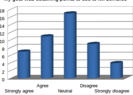
The outcome confirms the assumptions we made analysing the quantitative data. Some examples of qualitative data are shown in Fig. 4,5, 6: in the plots the value in y axis represents the number of users that given the answer reported on the x axis. Fig. 4 shows the students’ answers to the question item “The purpose was really interesting but I didn’t feel involved in mapping urban accessibility”, related to the mPASS app. As expected, students understood the importance of mapping urban accessibility but they didn’t feel motivated in contributing. Data in Fig. 5validate our assumption about the power of extrinsic motivation exploited using the voucher (question item “I was just interested in obtaining the voucher”). In Fig. 6 it is possible to see how the question item “My goal was
Figure 5. Answers to a item in the HINT! survey
Figure 6. Answers to a item in the Geo-Zombie survey
obtaining points to use to kill zombies” reveals different reactions in students: some students loved the game flow and played a lot as effect of intrinsic motivation, and others didn’t (in agreement with the hight value of standard deviation obtained by quantitative data).
6. Conclusion
and calculate personalize accessible path taking into account users preferences and special needs. In providing effective services, mPASS needs an updated and reliable picture of the urban accessibility. The system makes this possible allowing users to collect, voluntarily, georeferenced data via crowdsourcing and via crowdsensing. Usually, in this kind of crowdsourcing system there are few users that collect most of the data. This is a problem for mPASS that needs a wide audience of users to validate the mapped elements and avoid errors, which cannot be limited to people who directly benefit from the mapping activity.
To support the effectiveness and the trustworthiness of the data collection, it is necessary to attract different targets and enlarge the system community. With this in mind, we adopted gamification strategies in order to conceive and design few location based games that would engage a wide variety of users in mapping urban accessibility, exploiting intrinsic and extrinsic motiva-tion. Through a design process of ideation, concept validation, focus group and experience prototyping, we evaluated the game concepts, captured players reac-tions, comments and preferences before starting with the coding process.
The two best suited and well received games, HINT! and Geo-Zombie are being developed and tested. The results show the viability of our strategy in adopting gamification (and pervasive game) to enlarge the community of mPASS.
Acknowledgements.We thank all the participants (from the Madeira Interactive Technologies Institute and the University of Bologna) involved in this study. We would also like to thank Steven Dow and Jodi Forlizzi (Carnegie Mellon University) who provided us with precious suggestions, feedbacks and ideas.
References
[1] Giffinge, R.(2007), Smart cities: Ranking of european
medium-sized cities. URL http://smart-cities.eu/
download/smart_cities_final_report.pdf.
[2] (2011), World report on disability. URL http: //www.who.int/disabilities/world_report/2011/
accessible_en.pdf.
[3] Walker, A., Maher, J., Coulthard, M., Goddard,
E. and Thomas, M. (2001), Living in britain:
Results from the 2001 general household survey.
URL http://www.ons.gov.uk/ons/rel/ghs/
general-household-survey/2001-edition/
living-in-britain--full-report.pdf.
[4] Prandi, C., Salomoni, P. and Mirri, S. (2014) mpass:
Integrating people sensing and crowdsourcing to map urban accessibility. In Consumer Communications and Networking Conference (CCNC), 2014 IEEE 11th: 591– 595. doi:10.1109/CCNC.2014.6940491.
[5] Deichmann, J. (2004) Accessible urban spaces âĂŞ a
challenge for urban designers. In Walk21-V Citiesfor
People. URL http://www.walk21.com/papers/ Copenhagen%2004%20Deichmann%20Accessible%
20Urban%20Spaces.pdf.
[6] Mirri, S., Prandi, C., Salomoni, P., Callegati, F.
and Campi, A. (2014) On combining crowdsourcing,
sensing and open data for an accessible smart city. In Next Generation Mobile Apps, Services and Technologies (NGMAST), 2014 Eighth International Conference on: 294–299. doi:10.1109/NGMAST.2014.59.
[7] Mirri, S., Prandi, C. and Salomoni, P. (2014) A
context-aware system for personalized and accessible pedestrian paths. In High Performance Computing Simulation (HPCS), 2014 International Conference on: 833–840. doi:10.1109/HPCSim.2014.6903776.
[8] Seaborn, K. and Fels, D.I. (2015) Gamification
in theory and action: A survey. International Journal of Human-Computer Studies 74: 14 – 31. doi:http://dx.doi.org/10.1016/j.ijhcs.2014.09.006, URL http://www.sciencedirect.com/science/article/
pii/S1071581914001256.
[9] Hosseini, M., Phalp, K., Taylor, J.andAli, R. (2014)
The four pillars of crowdsourcing: A reference model. In Research Challenges in Information Science (RCIS), 2014 IEEE Eighth International Conference on: 1–12. doi:10.1109/RCIS.2014.6861072.
[10] Pan, Y.andBlevis, E.(2011) A survey of crowdsourcing
as a means of collaboration and the implications of crowdsourcing for interaction design. In Collaboration Technologies and Systems (CTS), 2011 International Conference on: 397–403. doi:10.1109/CTS.2011.5928716.
[11] von Ahn, L. and Dabbish, L. (2004) Labeling
images with a computer game. In Proceedings of the SIGCHI Conference on Human Factors in Computing Systems, CHI ’04 (New York, NY, USA: ACM): 319–326. doi:10.1145/985692.985733, URL
http://doi.acm.org/10.1145/985692.985733.
[12] von Ahn, L. (2006) Games with a purpose. Computer
39(6): 92–94. doi:10.1109/MC.2006.196.
[13] von Ahn, L. and Dabbish, L. (2008) Designing
games with a purpose. Commun. ACM 51(8): 58–67. doi:10.1145/1378704.1378719, URL http://doi.acm.
org/10.1145/1378704.1378719.
[14] von Ahn, L.,Ginosar, S.,Kedia, M.,Liu, R.andBlum, M.(2006) Improving accessibility of the web with a
com-puter game. InProceedings of the SIGCHI Conference on Human Factors in Computing Systems, CHI ’06 (New York, NY, USA: ACM): 79–82. doi:10.1145/1124772.1124785,
URLhttp://doi.acm.org/10.1145/1124772.1124785.
[15] Harris, C.G. (2012) The application of crowdsourcing
and games to information retrieval. Bulletin of IEEE Technical Committee on Digital Libraries8(2).
[16] Borodin, Y., Bigham, J.P., Stent, A. and
Ramakr-ishnan, I.V. (2008) Towards one world web with
hearsay3. InProceedings of the 2008 International Cross-disciplinary Conference on Web Accessibility (W4A), W4A ’08 (New York, NY, USA: ACM): 130–131. doi:10.1145/1368044.1368074, URL http://doi.acm.
[17] Takagi, H., Kawanaka, S., Kobayashi, M., Itoh, T.
and Asakawa, C. (2008) Social accessibility:
Achiev-ing accessibility through collaborative metadata author-ing. In Proceedings of the 10th International ACM SIGACCESS Conference on Computers and Accessibil-ity, Assets ’08 (New York, NY, USA: ACM): 193–200. doi:10.1145/1414471.1414507, URL http://doi.acm.
org/10.1145/1414471.1414507.
[18] von Ahn, L., Maurer, B., McMillen, C., Abraham,
D. and Blum, M. (2008) recaptcha: Human-based
character recognition via web security measures.Science
321(5895): 1465–1468. doi:10.1126/science.1160379,
URL http://www.sciencemag.org/content/321/
5895/1465.abstract. http://www.sciencemag.org/
content/321/5895/1465.full.pdf.
[19] Dotsub. URLhttps://dotsub.com/. Retrieved: Septem-ber, 2015.
[20] Miele, J. (2012) The descriptive video exchange:
the technology and implications of crowd-sourced description. InCSUN 2012.
[21] Alt, F., Shirazi, A.S., Schmidt, A., Kramer, U. and
Nawaz, Z. (2010) Location-based crowdsourcing:
Extending crowdsourcing to the real world. In Proceedings of the 6th Nordic Conference on Human-Computer Interaction: Extending Boundaries, NordiCHI ’10 (New York, NY, USA: ACM): 13– 22. doi:10.1145/1868914.1868921, URL http:
//doi.acm.org/10.1145/1868914.1868921.
[22] Amazon mechanical turk. URL https://www.mturk.
com/mturk/welcome. Retrieved: Obtober, 2015.
[23] Hara, K., Le, V. andFroehlich, J. (2013) Combining
crowdsourcing and google street view to identify street-level accessibility problems. InProceedings of the SIGCHI Conference on Human Factors in Computing Systems, CHI ’13 (New York, NY, USA: ACM): 631–640. doi:10.1145/2470654.2470744, URL http://doi.acm.
org/10.1145/2470654.2470744.
[24] Access together. URL http://www.accesstogether. org/. Retrieved: Obtober, 2015.
[25] Axsmap. URL http://www.axsmap.com/. Retrieved: Obtober, 2015.
[26] Kouroupetroglou, C.andKoumpis, A.(2014), Human
access: evolution of a crowdsourcing accessibility evaluations mobile ap. URL http://www.w3.org/WAI/
RD/2014/way-finding/paper4/. Extended Abstract for
the RDWG Symposium on Accessible Way-Finding Using Web Technologies.
[27] Wheelmap. URLhttp://wheelmap.org/en/. Retrieved: Obtober, 2015.
[28] Open street map. URL http://www.openstreetmap. org/. Retrieved: Obtober, 2015.
[29] Cardonha, C., Gallo, D., Avegliano, P., Herrmann,
R., Koch, F. and Borger, S. (2013) A crowdsourcing
platform for the construction of accessibility maps. In Proceedings of the 10th International Cross-Disciplinary Conference on Web Accessibility, W4A ’13 (New York, NY, USA: ACM): 26:1–26:4. doi:10.1145/2461121.2461129,
URLhttp://doi.acm.org/10.1145/2461121.2461129.
[30] Holone, H. and Misund, G. (2008) People helping
computers helping people: Navigation for people with mobility problems by sharing accessibility annotations. In Proceedings of the 11th International Conference on Computers Helping People with Special Needs, ICCHP ’08 (Berlin, Heidelberg: Springer-Verlag): 1093–1100. doi:10.1007/978-3-540-70540-6_164, URL http://dx.
doi.org/10.1007/978-3-540-70540-6_164.
[31] Kean, K. and Nisi, V. (2014) Experience Prototyping:
Gathering Rich Understandings to Guide Design(The name of the publisher), 224–237. doi: 10.4018/978-1-4666-4623-0.ch011.
[32] Phonegap. URL http://phonegap.com/. Retrieved: Obtober, 2015.
[33] Postgresql. URL http://www.postgresql.org/. Retrieved: Obtober, 2015.
[34] Postgis. URLhttp://postgis.net/. Retrieved: Obtober, 2015.
[35] Benford, S., Magerkurth, C. and Ljungstrand,
P. (2005) Bridging the physical and digital in
pervasive gaming. Commun. ACM 48(3): 54– 57. doi:10.1145/1047671.1047704, URL http: