S H O R T C O M M U N I C A T I O N
Open Access
How to utilize vegetation survey using
drone image and image analysis software
Yong-Gu Han
1, Se-Hoon Jung
2and Ohseok Kwon
1,3*Abstract
This study tried to analyze error range and resolution of drone images using a rotary wing by comparing them with field measurement results and to analyze stands patterns in actual vegetation map preparation by comparing drone images with aerial images provided by National Geographic Information Institute of Korea. A total of 11 ground control points (GCPs) were selected in the area, and coordinates of the points were identified. In the analysis of aerial images taken by a drone, error per pixel was analyzed to be 0.284 cm. Also, digital elevation model (DEM), digital surface model (DSM), and orthomosaic image were abstracted. When drone images were comparatively analyzed with coordinates of ground control points (GCPs), root mean square error (RMSE) was analyzed as 2.36, 1.37, and 5.15 m in the direction of X, Y, and Z. Because of this error, there were some differences in locations between images edited after field measurement and images edited without field measurement. Also, drone images taken in the stream and the forest and 51 and 25 cm resolution aerial images provided by the National Geographic Information Institute of Korea were compared to identify stands patterns. To have a standard to classify polygons according to each aerial image, image analysis software (eCognition) was used. As a result, it was analyzed that drone images made more precise polygons than 51 and 25 cm resolution images provided by the National Geographic Information Institute of Korea. Therefore, if we utilize drones appropriately according to characteristics of subject, we can have advantages in vegetation change survey and general monitoring survey as it can acquire detailed information and can take images continuously.
Keywords: Vegetation survey, Actual vegetation map, Drone image, Aerial image, Image analysis software
Introduction
A drone is an air plane or a helicopter-shaped flying object which flies by radio waves as unmanned aerial vehicle (UAV) or remotely piloted aircraft (RPA) (Lee 2015). Drones were initially developed for the military purpose such as combat or reconnaissance but now they are used in diverse parts including surveillance, transportation, ob-servation, agriculture, and leisure. It is expected that they will be used in more diversified areas in the future. Drones can be classified as fixed wing drones and rotary wing drones according to the method of operation. The most popular fixed wing drone in Korea is eBee developed by Sensefly, a Swiss company. On the other hand, popular
rotary wing drones are Phantom series and Inspire series by DJI, a Chinese company. Fixed wing drones and rotary wing drones have some strengths and weaknesses. Fixed wing drones can fly longer than rotary wing drones be-cause of energy efficiency as they fly using air lift force but they need a certain space for taking-off and landing. Al-though rotary wing drones can take off and land vertically, they can fly for shorter time than fixed wing drones be-cause of low energy efficiency.
Recently, many universities and laboratories have per-formed various researches on drones. There are studies on topographic survey of open cast mines using rela-tively cheap drones (Phantom 2 vision+, DJI, China) (Lee and Choi 2015), on comparison of topographic sur-vey results by a fixed wing drone (eBee, SenseFly, Switzerland) and a rotary wing drone (Phantom 2 vision +, DJI, China) (Lee and Choi 2016), and on sight analysis and utilization method (Kim 2014). In particular, many * Correspondence:[email protected]
1
Institute of Plant Medicine, Kyungpook National University, Daegu 41566, South Korea
3School of Applied Biosciences, College of Agriculture and Life Sciences Kyungpook National University, Daegu 41566, South Korea
Full list of author information is available at the end of the article
studies have been made in ecology field relating with preparation of actual vegetation map and classification of stands patterns such as monitoring invasive alien spe-cies (The National Institute of Ecology 2015), precise vegetation survey in forest swamps (Korea National Ar-boretum 2015), and a study on forest swamp biotope (Korea National Arboretum 2016).
It is said that images taken by drones have some exterior orientation distortion because of tilting caused by wind or movement and some interior orientation distortion according to camera and lens mounted on the drone. Therefore, the images taken by drones should be corrected (Kim et al. 2015). Additionally, as it is reported that drone images have multicentimeter level higher space resolution com-pared with satellite images (Tahar et al. 2011, Kim et al. 2015), drones can provide higher resolution im-ages than portal site maps provided by Daum, Naver, or Google or aerial images provided by National Geo-graphic Information Institute of Korea. Especially, the
aforementioned aerial images are not current images updated real time so there is a tendency to show dif-ferent pictures from current status in highly disturbed areas by invasive alien species such as stream or low-land forests. In case of streams, it is difficult to analyze geomorphological landscapes or fine land-scapes in the field of mathematical ecology with 1/ 25,000 scaled and 1/5000 scaled digital maps distrib-uted by National Geographic Information Institute be-cause the minimal contour line unit is 10 cm in those maps (Kim 2014). It is supposed that we can save time and efforts while obtaining highly precise survey results if we perform studies based on drone images taken in advance. However, the use of drones in ecological field has been used without any under-standing the error range and resolution for each model.
Accordingly, this study tried to analyze error range and resolution of drone images using a most popular ro-tary wing drone (Phantom 3 Professional, DJI, China) by comparing them with field measurement results and to analyze stands patterns in actual vegetation map prepar-ation by comparing drone images with aerial images provided by National Geographic Information Institute of Korea.
Materials and methods
Research equipment and subject area
In this study, one of popular drones (Phantom 3 Profes-sional, DJI, China) was used. Its detailed specifications are shown in Table 1. Drone images were taken during the automatic flight using smartphone application pro-vided by DJI (Fig. 1). Images were taken in force land of the right bank of Geum river near Shinkwan-dong, Gongju-si, Chungcheongnam-do, and the forest near Namcheon Camping Ground in Mt. Sobaek National
Table 1Specifications of Phantom 3 Professional aircraft used in this study
Weight 1280 g
Flight time 23 min
Max. speed 16 m/s
(ATTI mode, no wind)
Max. flight altitude 6000 m
Camera spec. COMS Sony EXMOR 1/2.3
Lens f/2.8(20 mm)
FOV FOV 94°
ISO range 100–3200 Image size 4000 × 3000
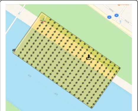
Fig. 1Automatic flight routes set in the study area
Table 2Coordinates of the ground control points (GCPs) set in the study area
ID of GCP X(m) Y(m) Z(m)
1 429,893.033 211,724.547 12.074
2 429,949.239 211,642.727 12.052
3 430,005.625 211,560.625 12.009
4 430,064.853 211,474.217 12.039
5 429,954.175 211,539.679 10.551
6 430,028.262 211,430.257 10.984
7 429,959.587 211,356.582 11.326
8 429,911.441 211,446.120 10.767
9 429,839.064 211,581.880 9.354
10 429,858.228 211,628.996 10.426
Park near Namcheon-ri, Youngchun-myeon, Danyang-gun, and Chungcheongbuk-do.
Data processing
Error ranges of drone images were identified by compar-ing with field measurement results. For field measure-ments, 11 ground control points (GCPs) were selected in force land of the right bank of Geum river near Shinkwan-dong, Gongju-si, and Chungcheongnam-do. Measurements were finally calibrated after the mea-surement in the unified control points (UCPs) near the research area. For latitude, longitude, and altitude coor-dinates of ground control points, VRS/RTK-GPS were used (Table 2).
For vegetation pattern analysis in actual vegetation map, aerial images by National Geographic Informa-tion Institute of Korea (51 and 25 cm grade) and drone images were used. The analysis was made using image analysis software (eCognition, Trimble, USA). Image editing of aerial images taken in the field was performed using photogrammetry software such as Pix4Dmapper Pro (Pix4D, Switzerland) and PhotoScan Professional (Agisoft, Russia). In case of program edit-ing mechanism, a sedit-ingle image can be obtained as each drone image-taking point has a GPS coordinate and a drone takes images overlapped. Additionally, an orthomosaic image can be made as the aforemen-tioned program allows geometric correction by auto-matic aerial triangulation (AAT) (Siebert and Teizer 2014, Lee and Choi 2015).
Results and discussion
Analysis of error range and resolution of drone images through field measurement
To analyze resolution and error range of drone images taken by a popular drone, Phantom 3 Professional, total 11 ground control points were selected in the area
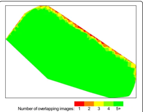
(Fig. 2) and coordinates of the points were identified (Table 2). The height of drones was maintained as 80 m, horizontal and vertical overlapping were set as 80% re-spectively, and total area of 10.35 ha was imaged. Pictur-ing time was about 22 min and total 267 aerial images were taken. It took about 6 h for an editing program to edit aerial images taken by a drone. Excluding edges, more than five aerial images were overlapped in most cases (Fig. 3). In the analysis of aerial images taken by a drone, error per pixel was analyzed to be 0.284 cm. Digital elevation model (DEM), digital surface model
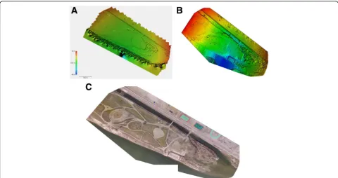
(DSM), and orthomosaic image were abstracted
through these data (Fig. 4). Aerial images taken in the subject area had 30 cm grade resolution and it was analyzed to be similar to 20 cm resolution images taken by Kim (2014) at the same height in Gapcheon river in Daejeon. When drone images were compara-tively analyzed with coordinates of ground control points (GCPs), root mean square error (RMSE) was Fig. 2Locations of ground control points (GCPs) installed in the study area
analyzed as 2.36, 1.37, and 5.15 m in the direction of X, Y, and Z (Table 3). Because of this error, there were some differences in locations between images edited after field measurement and images edited without field measurement (Fig. 5). Therefore, it is judged that monitoring through field measurement is necessary when precise data are required such as ecology disturbing species distribution monitoring or unusual plant community monitoring.
Comparison of community classification according to aerial images in preparation of actual vegetation map
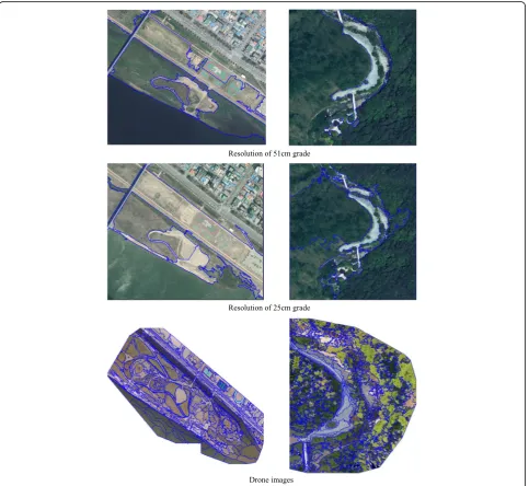
Actual vegetation map which is the basis of vegeta-tion survey diagrams currently distributed vegetavegeta-tion. It can be utilized in various fields such as land de-velopment and forest management including phyto-sociological spatial analysis as it provides precise vegetation information quickly (Kim and Lee 2006). Such actual vegetation map is prepared indoor based on images provided by portal sites such as Daum, Naver, or Google or aerial images provided by Na-tional Geographic Information Institute of Korea be-fore field survey. Communities are divided by bare eye judgment of a vegetation expert and community name is given by identifying dominant species in basic field survey. Therefore, drone images taken in the stream and the forest and 51 and 25 cm reso-lution aerial images provided by National Geographic Information Institute of Korea were compared to Fig. 4Results of digital elevation model (DEM;a), digital surface model (DSM;b), and orthomosaic image (c)
Table 3Accuracy of orthomosaic images made from ground control points (GCPs)
GCPs X(m) Y(m) Z(m)
1 −2.87 −0.70 −10.67
2 −2.40 −0.55 −3.75
3 −1.87 −0.94 −2.02
4 −1.62 −1.34 −6.35
5 −1.93 −1.02 4.71
6 −1.52 −1.83 −1.86
7 −1.94 −2.55 −2.51
8 −2.29 −2.31 5.48
9 −3.22 −0.65 6.99
10 −3.07 −0.45 2.10
11 −2.53 −0.46 2.05
Mean −2.30 −1.16 −0.53
RMSE 2.36 1.37 5.15
identify stands patterns. To have a standard to clas-sify polygons according to each aerial image, image analysis software eCognition (Trimble, USA) was used. The software automatically actuates polygons with the same scale for the same area (stream scale parameter: 700, forest scale parameter: 500). It was analyzed that drone images made more precise polygons than 51 and 25 cm resolution images provided by National Geographic Information Institute of Korea (Fig. 6). It is partly because resolution of drone images is higher than images provided by National Geographic Information Institute of Korea and partly because there was difference in picturing time and weather condition. On the other hand, in case of the stream with heavy seasonal changes and forest edges with
high probability of development, aerial images provided by National Geographic Information Institute of Korea or portal sites such as Daum, Naver, and Google are tend to be very much different from current status as they do not provide real time images. Therefore, if we utilize drones appropriately according to characteristics of subject, we can have advantages in vegetation change survey and gen-eral monitoring survey as it can acquire detailed informa-tion and can take images continuously. Addiinforma-tionally, we may be able to identify area where unusual plants can be shown and vegetation hotspot area in advance and utilize them in the study. It is expected to be actively used in the future as it saves time for survey and returns highly precise research results.
Abbreviations
AAT:Automatic aerial triangulation; DEM: Digital elevation model; DSM: Digital surface model; GCPs: Ground control points; RMSE: Root mean square error; RPA: Remotely piloted aircraft; UAV: Unmanned aerial vehicle; UCPs: Unified control points
Acknowledgements
This subject is supported by Korea Ministry of Environment (MOE) as“Public Technology Program based on Environmental Policy (2014000210003)”.
Publisher’s Note
Springer Nature remains neutral with regard to jurisdictional claims in published maps and institutional affiliations.
Funding
This subject is supported by the Korea Ministry of Environment (MOE) as “Public Technology Program based on Environmental Policy
(2014000210003)”.
Availability of data and materials
Not applicable
Authors’contributions
Y-GH mainly analyzed and interpreted the image data using diverse software and was a major contributor in writing the manuscript. S-HJ mainly collected the image data with the drone and arranged the data using some software to analyze. OK mainly designed this work and revised the paper totally. All authors read and approved the final manuscript.
Competing interests
The authors declare that they have no competing interests.
Consent for publication
Not applicable.
Ethics approval and consent to participate
Not applicable.
Author details 1
Institute of Plant Medicine, Kyungpook National University, Daegu 41566, South Korea.2Institute of Ecosystem Restoration Planning, Daejeon 34543, South Korea.3School of Applied Biosciences, College of Agriculture and Life Sciences Kyungpook National University, Daegu 41566, South Korea.
Received: 11 October 2016 Accepted: 31 October 2016
References
Arboretum, K. N. (2015).Report of research and monitoring on wetlands of civil owned forest. Pocheon: Korea National Arboretum.
Arboretum, K. N. (2016).Conservation projects of forest wetlands. Pocheon: Korea National Arboretum.
Kim, S. M. (2014). Study of the UAV for application plans and landscape analysis.Journal of the Korean Institute of Traditional Landscape Architecture, 32, 213–220.
Kim, J. W., & Lee, Y. K. (2006).Classification and assessment of plant communities. Seoul: World Science.
Kim, B. J., Lee, Y. K., & Choi, J. K. (2015). Investigating applicability of unmanned aerial vehicle to the tidal flat zone.Korean Journal of Remote Sensing, 31, 461–471.
Lee, W. G. (2015).Urban managements using drones. Busan: Busan Development Institute.
Lee, S. J., & Choi, Y. S. (2015). Topographic survey at small-scale open-pit mines using a popular rotary-wing unmanned aerial vehicle (drone).Tunnel & Underground space, 25, 462–469.
Lee, S. J., & Choi, Y. S. (2016). Comparison of topographic surveying results using a fixed-wing and a popular rotary-wing unmanned aerial vehicle (drone). Tunnel & Underground space, 26, 24–31.
National Institute of Ecology. (2015).Monitoring of invasive alien species designated by the Wildlife Protection Act (II). Seocheon: National Institute of Ecology. Korea.
Siebert, S., & Teizer, J. (2014). Mobile 3D mapping for surveying earthwork projects using an unmanned aerial vehicle (UAV) system.Automation in Construction, 41, 1–14.
Tahar, K. N., Ahmad, A., & Wan Mohd Akib, W. A. A. (2011).UAV-based stereo vision for photogrammetric survey in aerial terrain mapping. Penang: Proceedings of IEEE International Conference on Computer Applications and Industrial Electronics.
• We accept pre-submission inquiries
• Our selector tool helps you to find the most relevant journal
• We provide round the clock customer support
• Convenient online submission
• Thorough peer review
• Inclusion in PubMed and all major indexing services
• Maximum visibility for your research
Submit your manuscript at www.biomedcentral.com/submit