L O C A T I O N - B A S E D S E R V I C E S
L
ocation is a core concept in most pervasive computing systems. Beyond simple uses such as pin-pointing an individual’s position or identifying a region’s occupants, location is a key index for richer querying of an individual’s or environment’s context.Although at first glance a simple concept, lo-cation information’s representation has many forms and subtleties, each suited to particu-lar application classes.1 To provide application
developers with easy access to location information, we must support different posi-tioning systems with varying data formats as well as fusion algorithms to estimate posi-tion from multiple readings. We also need a data access ap-proach that hides this complex-ity and heterogenecomplex-ity from the developer. This problem has no general solution, necessitating specific frame-works for working with specific kinds of data.
To meet the needs of location-based applica-tions, we’ve developed lightweight space and sensing models and a set of extensible compo-nents that support customization and emerging
technologies. The space model supports a range of geometric and relative-spatial-positioning descriptions found in the literature. The sens-ing model abstracts over various types of posi-tioning systems and incorporates the capture of uncertainty, serving as a foundation on which developers can apply sensor-fusion techniques. Our programming framework, LOC8, sits atop the space and sensing models, providing a rich API for querying location data and exploring its many representations.
Requirements
A location model should support location data representations from different positioning tech-nologies and extensible metadata descriptions. Many well-known systems can report an enti-ty’s coordinate or symbolic position, from GPS and Active Badge to more recent systems such as Ubisense and the fingerprint-based position-ing system.2 Beyond these are less conventional
and less expensive methods of reporting an en-tity’s location. For example, a Bluetooth spot-ter, which can detect the presence of mobile phones, PDAs, and laptops, might position a de-vice within 10 meters of a known point. We can use this information to infer the device owner’s position.
Using a location model supporting a range of expressive representations
for spaces, spatial relationships, and positioning systems, the authors
created LOC8, a programming framework for exploring location data’s
multifaceted representations and uses.
Graeme Stevenson and Juan Ye
University College Dublin Simon Dobson
University of St. Andrews Paddy Nixon
University College Dublin
LOC8: A Location
Model and Extensible
Framework for
of location-centric primitives is impor-tant. Because no positioning technol-ogy claims to provide perfect accuracy, this language must also provide quality measures to support sensor-fusion tech-niques for uncertain data. Quantifying uncertainty associated with positioning systems has proved a hot topic in recent years.3,4
A space model provides a set of prim-itives that allow descriptions of regions of space and the relationships between them. Such primitives must support the mapping of positioning systems’ differ-ent data formats while being expressive enough to support common application queries.
Christian Becker and Frank Durr divide these queries into four catego-ries: positioning, range, nearest neigh-bor (spatial relation), and navigation.5
These queries have led to more complex uses of location. Such higher-level que-ries require flexible conversion between different location representations—for example,
• building a relative spatial relation-ship between two mobile entities, or • translating a track of an entity’s
physical positions to a summary of its movement pattern or to its speed and heading.6
Increasingly, researchers don’t treat location information as independent but rather as tightly bound to user ac-tivity, intention, and interaction. The extension of semantics in location is a popular research topic, underpin-ning many potential context-aware applications.1
Realizing the Space Model
To represent our space model,7 we chose
the Web Ontology Language (OWL) because of its high-quality tool support and the applicability of reasoners and rules to help identify relationships be-tween points and regions. At the heart
friendly names and geometric extents of regions (such as rooms and buildings) and their physical relationships to other parts of the model.
Coordinates have an associated co-ordinate reference system (CRS), which can be a global standard or locally de-fined to simplify a region’s spatial rep-resentation. For example, if an appli-cation is bound to a single building, it makes more sense to define a local coor-dinate system than to use the WGS 84
coordinate system. Translations from one CRS to another are described by an origin point and a rotation matrix. The origin is the displacement of the new CRS relative to its reference CRS, and the rotation matrix describes changes to rotation of the x-, y-, and z-axes. We used Chianghao Jiang and Peter Steen-kiste’s model8 to convert coordinates
from one CRS to another. Geometric regions consist of one or more 2D or 3D geometric shapes, each defined by a set of coordinates; symbolic represen-tations take the form of an individual associated with a descriptive label.
Developers must assign each space a granularity (the granularity property), whose possible values, such as coordi-nate, room, and city, are defined in the model and are customizable. This al-lows flexibility in that developers can redefine granularities to suit different applications. The querying process uses granularities to request an entity’s loca-tion at a particular resoluloca-tion.
Our model supports four spatial re-lationships: containment, adjacency, connectedness, and overlap. Contain-ment, adjacency, and overlap are what their names suggest. Connectedness is
specify a third location, such as an exit or elevator, that enables the transition. Connectedness is a rich relationship, implying both the passage’s direction and the notion of an accessible (rather than a straight-line) distance between the related locations.
We also provide two types of relative representation: center and compass.7
In the center representation, a target location is a geometric area, such as a circle or a cuboid, whose center is
a coordinate—or a reference loca-tion’s center point—and whose edge or diameter length is twice a speci-fied distance. The compass represen-tation involves building a CRS whose origin is a coordinate—or a reference location’s center point—and whose rotation matrix follows the standard compass directions. In this CRS, the target location’s description contains a distance to its origin; the horizontal angle to the target location, measured clockwise from north; and the angle of elevation from the horizontal plane.
For some maps, specifying a set of symbolic regions and their spatial re-lationships will suffice. Maps that de-fine region geometry let reasoners infer some symbolic relationships, such as containment and adjacency, and esti-mate missing geometry.
Realizing the Sensing Model
The sensing model maps the reported positions of entities—for example, a person, locatable tag, or wireless device—to points and regions in our space model. (For an overview of the high-level ontologies we use to describe our applications, see “Ontonym: A
A space model provides a set of primitives
that allow descriptions of regions of space
LOCATION-BASED SERVICES
Collection of Upper Ontologies for De-veloping Pervasive Systems.”9) Again,
the essential part of this process is cap-turing metadata associated with the sensing process.
We adopt a standard approach to rep-resenting the sensed data’s characteris-tics and imperfections by using a quality matrix, which satisfies the sensing mod-el’s uncertainty measure requirement.
The quality matrix consists of granu-larity, frequency, coverage, and a list of accuracy and precision pairs.10
Granu-larity is the smallest spatial element per-ceivable. Frequency is the sample rate— how often a sensor generates readings. The sensor manufacturers’ technical specifications determine these proper-ties’ values. Coverage is the extent of space in which an entity’s position can be sensed; the accuracy and precision pairs, which might be multiply defined, describe the probability that an entity’s true position is within a given distance of the reported value. For example, with our Ubisense installation in University College Dublin’s Complex and Adap-tive Systems Laboratory (CASL) build-ing, we achieve 70 percent accuracy with two meters’ precision. Although our general quality matrix works with most positioning sensors, it isn’t defini-tive, and we encourage its extension.
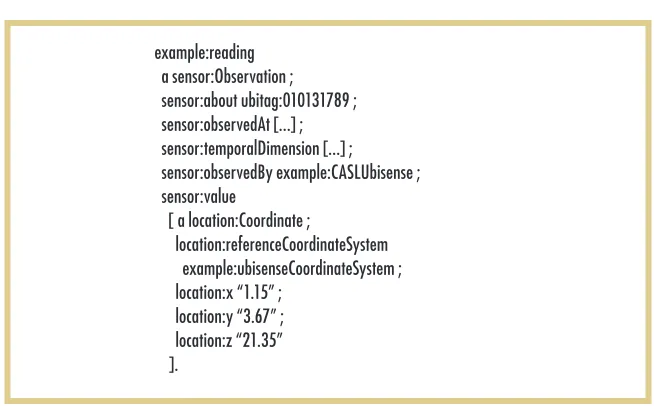
All data that a sensor adds to the model references the sensor’s quality matrix. Figure 1 describes the granular-ity, frequency, coverage, and precision- accuracy pairs associated with our Ubisense sensor; Figure 2 describes a sample reading. Both figures use No-tation 3 (www.w3.org/DesignIssues/ Notation3), a compact Resource De-scription Framework (RDF) syntax.
The about property relates the reading to a particular entity, and the observedBy
property relates the reading to the sen-sor that provided it. The value property indicates the position at which the sen-sor located the entity—in this case, a 3D coordinate. Finally, the temporal-Dimension property specifies the time span over which developers should re-gard the reading’s value as reflecting the entity’s true position.
Developers can easily add a position-ing system to the model, which requires only that they define its metamodel and write a software adapter to transform sensor-reported positions to our model. Optionally, if the positioning system re-ports coordinates, developers can spec-ify the necessary information to trans-late points from its CRS to another CRS.
example:CASLUbisense a sensor:Sensor ;
sensor:coverage map:3f , map:4f ; sensor:frequency [...] ;
sensor:granularity map:coordinateGranularity ; sensor:precisionAccuracy
[ a sensor:PrecisionAccuracy ; sensor:accuracy “0.7” ; sensor:precision [ a muo:QualityValue ; muo:measuredIn ucum:meter ; muo:numericalValue “2” ]
];
sensor:precisionAccuracy [...] sensor:rateOfChange [...] .
example:reading a sensor:Observation ; sensor:about ubitag:010131789 ; sensor:observedAt [...] ; sensor:temporalDimension [...] ; sensor:observedBy example:CASLUbisense ; sensor:value
[ a location:Coordinate ;
location:referenceCoordinateSystem example:ubisenseCoordinateSystem ; location:x “1.15” ;
[image:3.585.45.370.91.308.2]location:y “3.67” ; location:z “21.35” ].
Figure 1. An abridged description of University College Dublin’s Complex and Adaptive Systems Laboratory (CASL) Ubisense sensor and its metadata. The sensor covers the third and fourth floors of the CASL building, and is accurate to within two meters of a Ubitag’s true position 70 percent of the time. Distance descriptions use the Measurement Units Ontology (MUO), giving a basis for transforming between different representations.
[image:3.585.44.371.392.595.2]Using the
Programming Framework
On the basis of Jeffrey Hightower and his colleagues’ Location Stack architec-ture11 (see the “Related Work in
Loca-tion Modeling” sidebar), we developed the LOC8 framework in Java to
sup-port querying of the space and sensing models we constructed. Figure 3 shows LOC8’s architecture. The sensing layer reports positioning data as coordi-nates, symbolic locations, or relative positions; the abstraction layer converts raw sensor data into the OWL
repre-sentation. As part of this process, the abstraction layer can query the context and space models to find the correct references for resources representing particular regions, people, or locat-able objects. The context, sensing, and space models provide standard APIs for
makes developing location-aware applications easier.1 The Nexus platform’s core is a common augmented-world model that sup-ports representation of the location of static real-world entities, such as buildings or trains, and virtual entities with which the real world is augmented, such as virtual billboards. Its query lan-guage, Augmented World Query Language (AWQL), supports basic spatial queries including inside, overlaps, includes, excludes, and closest. In LOC8 (see the main article), we use a loosely coupled modeling technique that treats location information indepen-dently from other forms of context. This lets us treat all locatable objects in the same way, irrespective of their property structure, real or virtual status, and use by applications.
The Location Stack is a successful software engineering model that structures location-aware services components into a lay-ered system architecture with robust separation of concerns.2,3 Our model is based on the Location Stack but differs in four main respects. First, the Location Stack’s measurements layer reports data from sensors at a lower level than we support, including distance, angle, and proximity. We decided to deal only with observations at the position level—for example, coordinate and symbolic—because most technologies tend to perform this cal-culation/abstraction in the sensing system.
Second, we cleanly separate the space model from the sensing model, letting us treat the data in each independently. For ex-ample, the sensing model’s implementation decides the length of time to retain readings. In contrast, the space model remains relatively static, but the LOC8 frameworkapplies reasoning to its contents to infer additional spatial relationships from available geometric data.
Third, we’ve taken a cross-layered approach to LOC8’s design, recognizing that context and space information can play a role before and during the point of fusion. In contrast, the Location Stack introduces contextual fusion only in its highest layers.
Fourth, the Location Stack architecture includes an arrange-ments layer, which uses information about the current probabi-listic location estimates of multiple objects to identify relation-ships between them, such as proximity or formation. This form of querying isn’t part of our framework’s core but is an extension that developers could build.
ordinate space models.4 Its interface extends traditional database SQL queries with spatial queries on the PostgreSQL database system, which improves performance and increases flexibility for location-aware applications. This location model supports flible conversion between different coordinate systems. We’ve ex-tended this idea in our location model. Although we don’t con-sider our implementation’s performance in the main article, we support the queries the Aura model identifies and extend them to support other forms, such as relative positioning.
Finally, MiddleWhere is a distributed middleware infrastructure for location that separates applications from location-sensing technologies.5 Similar to LOC8, it can add sensing technologies dynamically and transparently from an application perspective. However, the two approaches differ in uncertainty management. MiddleWhere provides Bayes-based probabilistic reasoning to fuse multiple sensor readings, whereas we focus on the generic representation of different sensor data and its quality. We expose this through the programming framework, providing an inter-face to accommodate different sensor-fusion approaches.
REFERENCES
1. F. Hohl et al., “Next Century Challenges: Nexus—an Open Global In-frastructure for Spatial-Aware Applications,” Proc. 5th Ann. ACM/IEEE Int’l Conf. Mobile Computing and Networking (MobiCom 99), ACM Press, 1999, pp. 249–255.
2. J. Hightower, B. Brumitt, and G. Borriello, “The Location Stack: A Layered Model for Location in Ubiquitous Computing,” Proc. 4th Workshop Mobile Computing Systems and Applications (WMCSA 02), IEEE CS Press, 2002, pp. 22–28.
3. A. LaMarca et al., “Delivering Real-World Ubiquitous Location Sys-tems,” Comm. ACM, vol. 48, no. 3, pp. 36–41.
4. C. Jiang and P. Steenkiste, “A Hybrid Location Model with a Comput-able Location Identifier for Ubiquitous Computing,” Proc. 4th Int’l Conf. Ubiquitous Computing (UbiComp 02), LNCS 2498, Springer, 2002, pp. 246–263.
LOCATION-BASED SERVICES
querying their contents. The fusion layer uses these APIs to calculate prob-abilities for an entity’s position and pro-vides a set of calls to invoke this func-tionality. Finally, the model’s top layer supports application querying, provid-ing modules for each of the four query categories.
Positioning Queries
The most common query is for locat-ing an entity within a space model uslocat-ing available positioning data. LOC8 sup-ports this through its positioning-query module. We can configure the query us-ing six parameters:
• entity specifies the entity’s identifier. • finestGranularity and coarsestGranularity
constrain the result’s granularity (for example, coordinate, cubicle, or building).
• precision specifies a proximate distance the querying application requires, which affects the confidence value calculation.
• startTime and endTime specify the tempo-ral interval of interest.
The position query’s expanded inter-face is as follows:
1. List<PositionResult> locate(Entity entity, 2. Granularity finestGranularity, 3. Granularity coarsestGranularity, 4. Distance requiredPrecision, DateTime startTime, 5. DateTime endTime);
The API provides more compact variants using parameters’ default val-ues; for example, the time parameter defaults to the current time. Consider the following code for the positioning query, “Where is Bob?”:
1. Entity bob = sensorModel.getEntity(ENTITY_ URI + “Bob”);
2. List<PositionResult> results = positionQuery. locate(bob);
3. for (PositionResult result : results) { 4. if (result.getLocation(). hasSymbolicRepresentation()) { 5. System.out.printf(“%s - %s\n”, 6. result.getLocation(). asSymbolicRepresentation(), 7. result.getConfidence()); 8. }
9. }
In this code, we use the query API to obtain a list of candidates for Bob’s current position (lines 1 and 2). We then check whether each result has
an associated symbolic representation (line 4). If so, we print that representa-tion’s name to the console, along with its associated confidence value (lines 5 through 7).
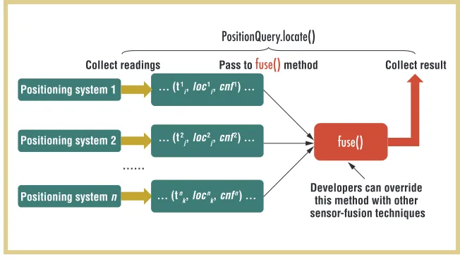
If the environment contains multiple positioning systems, we apply sensor fusion within the locate() method. This is a three-step procedure (see Figure 4): 1. Get all observations that satisfy
the query’s input requirements, including entity, time span, gran-ularity, and precision. Transform them into to a triple consisting of the reading’s starting time, a posi-tion ordered from finest granular-ity to required granulargranular-ity, and a confidence value that’s the sensor’s accuracy at the query’s required precision.
2. Pass the triples to the sensor-fusion method fuse(). Developers can ap-ply customized sensor-fusion tech-niques to fuse(). We’ve implemented a simple fuzzy-based fuse() that or-ganizes the collected readings in a tree structure according to their granularity and that uses fuzzy logic to update and integrate the confidences on this location data. 3. Order the results according to their
Query layer
Fusion layer
Space model Context
model Sensing model Abstraction
Sensing
PositionQuery.locate()
Positioning system 1
Positioning system 2
Positioning system n
fuse() Collect readings Pass to fuse() method
Developers can override this method with other sensor-fusion techniques
Collect result
…… ... (t1
i, loc1i, cnf1) ...
... (t2
j, loc2j, cnf2) ...
... (tn
[image:5.585.212.538.90.274.2]k, locnk, cnfn) ...
Figure 3. LOC8’s architecture. Sensors provide raw data, which is translated to our model and mapped to entity and space descriptions. An interface for performing sensor fusion is exposed, while the top layer of the framework provides application developers with an API for common query types.
If we’re interested in Bob’s coordi-nate position rather than the symbolic name associated with his position, we must address two issues:
• how to translate results into a target coordinate system, and
• how to deal with situations in which a symbolic location has no explicit geometry.
To address the first issue, we translate the coordinate system using the ap-proach described earlier. For the second issue, we estimate geometry by assum-ing a space’s boundary is the composite of all its subspaces. If no such informa-tion is available, we approximate by in-heriting the geometry of a space’s super-space. Clearly, this process’s success depends on the amount of geometric information available and might not be suitable for all applications. So, devel-opers can use hasExplicitGeometricRegion() and
estimateGeometricRegion() at their discretion. The following code illustrates the task of plotting Bob’s position on a map:
1. Entity bob = sensorModel.getEntity(ENTITY_ URI + “Bob”);
2. PositionResult result = positionQuery. locateMax(bob);
3. Coordinate centerPoint = result.getLocation() 4. .asGeometricRegion().centerPoint(); 5. Coordinate translatedPoint = CoordinateUtils 6. .convert(centerPoint, mapCRS);
7. map.plot(bob, translatedPoint);
We calculate Bob’s position as we did in the previous example, this time us-ing locateMax() to return only the result with the highest confidence at the finest granularity (lines 1 and 2). Assuming Bob’s location has an associated geo-metric region, we use his position as that region’s center point (lines 3 and 4), transform it to the map’s coordinate system (lines 5 and 6), and call the ap-plication plot method (line 7).
tities in a location that match certain criteria. There are four input param-eters: space, the region whose contents we’re interested in; startTime and endTime, the time span we’re interested in; and
entityType, the entity class to locate. Each result consists of a reference to a located entity and a confidence value represent-ing the likelihood that the entity is in the location at the given time. The in-terface for the range query is as follows:
1. List<RangeResult> in(Space space, Class entityType,
2. DateTime startTime, DateTime endTime);
As with position queries, this method has several variants. The query defaults to returning all locatable entities cur-rently in the specified location if the querier omits time and entity type parameters.
To compute a result for a range query, we first query the entity model for the entities matching the specified type. We then use positioning queries to locate each entity. Finally, we check
whether each positioning query’s result matches, or is a subspace of, the speci-fied location.
We code the range question, “Who is in the CASL building?” as follows:
1. Space casl = spaceModel.getSpace(MAP_URI + “CASL”);
2. List<RangeResult> results = rangeQuery. in(casl,Person.class);
3. for (RangeResult result : results) { 4. System.out.printf(“%s - %s\n”, 5. result.getEntity(),
6. result.getConfidence()); 7. }
An iterator over the results prints the set of entities along with the confidence in each result (lines 3 through 7).
Spatial-Relation Queries
The spatial-relation module provides a set of methods for applications in which relations between locations are impor-tant. The API’s most basic method, re-lationship(), accepts two locations as pa-rameters and checks for containment, adjacency, overlap, and connectedness. Containment, adjacency, and overlap relationships are either expressed di-rectly in the model or calculated in pre-processing at runtime by comparing the geometric regions’ boundaries. Map designers must explicitly express con-nectedness. If none of these relation-ships exist between the spaces, the next step is to calculate the compass relative position between the two locations. If the locations don’t share a common CRS and can’t be translated to a com-mon CRS, the query is unanswerable.
We use several variants of the closest()
method to find proximate entities. Its
input parameters follow the same pat-tern as the previous queries, with the
space parameter providing an outer boundary for the search. We then cal-culate the results’ positions relative to the target entity and order them from closest to farthest. The method signa-ture is as follows:
1. List<ProximityResult> closest(Entity entity, 2. Space boundary, Class entityType, 3. DateTime startTime, DateTime endTime);
Consider a spatial-relation query in which we want to find the shop nearest
LOCATION-BASED SERVICES
Bob. To represent the answer symboli-cally or as a coordinate, we use the ap-proaches we just described. However, the final representation we identify is a relative position—for instance, 100
meters northwest. We achieve this by computing the distance and bearing be-tween the points:
1. Entity bob = sensorModel.getEntity(ENTITY_ URI + “Bob”);
2. Space campus = spaceModel.getSpace(MAP_ URI + “UCD”);
3. List<ProximityResult> results = relationQuery 4. .closest(bob, campus, Shop.class); 5. for (ProximityResult result : results) { 6. CompassLocation rel = result.getLocation() 7. .asCompassRelative(bob);
8. System.out.printf(“%s relative to %s: (%d %d)\n”,
9. bob, result.getEntity(), rel.getDistance(), 10. rel.getHorizontalAngle());
11. }
We look up the objects for Bob and for the University College Dublin cam-pus, which we use to limit the search space (lines 1 and 2). We then execute the query, limiting the search to entities that are shops (lines 3 and 4). The result is an ordered list of shops, from closest to farthest away. We iterate through the results, displaying the distance and hor-izontal angle between Bob and the tar-get shop for each (lines 5 through 11).
Navigation Queries
The navigation-query module sup-ports pathfinding between the mod-el’s different regions using a selection of path() methods that takes two pa-rameters—source and destination—which can be locations or entities. Methods that accept entities as parameters first calculate the entities’ positions using
the position-query module before pro-ceeding in the same manner as if the developers had passed a location. The basic pathfinding algorithm works as follows:
1. Check whether the source and des-tination locations are the same. 2. If the locations are the same, return
the answer.
3. If the locations aren’t the same, recursively call the pathfinding al-gorithm using each location con-nected to the source location as the new source, keeping track of paths to avoid cycles.
The algorithm has two versions— one that terminates after finding a path and another that searches all paths. This algorithm’s current implementa-tion is suited only for evaluating paths through small space models. Consid-ering source and destination locations with different granularities—for ex-ample, from Bob’s desk to the coffee area—increases the complexity. Im-proving this approach is a possible area of future research.
The navigation-query module can also calculate the distance between two locations. It determines the point-to-point Euclidian distance by first evalu-ating each location’s center point. If the connection relationship metadata pro-vides the accessible distance, it can also calculate the path-accessible distance.
Extending the previous example, the following code calculates the path be-tween Bob and the nearest shop:
1. Path path = navigationQuery.path(bob, nearestShop)
2. for (Step step : path.steps()) {
3. System.out.printf(“from %s to %s (%d)\n”, 4. step.getSource(),
5. step.getDestination(), 6. step.pathDistance()); 7. }
After the query executes (line 1), we iterate through each step in the path, printing out the details and the path-accessible distance for each (lines 2 through 7).
Combination Queries
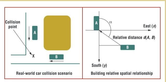
Constructing more sophisticated que-ries that use the core queque-ries we just described can simplify application de-velopment. Consider a scenario from the Cooperative Object Detection and Ranging (Codar) system demonstra-tion12 in which two cars are heading
for a collision (see Figure 5). We want to construct a service that predicts po-tential collisions and calculates their time and location. Here’s an outline of a simple implementation of this service:
1. PositionResult locA = positionQuery. locateMax(carA);
2. PositionResult locB = positionQuery. locateMax(carB);
3. CompassLocation rel = locB. asCompassRelative(locA); 4. …
5. Double degree = rel.getHorizontalAngle(); 6. if ((velocity(carB)/velocity(carA)) 7. == Math.abs(Math.tan(degree))) { 8. Double collisionTime = rel.getDistance() 9. / relativeVelocity(carB, carA); 10. ...
11. }
Treating car A as a base location, we can deduce car B’s position relative to A using our relative-positioning que-ries (lines 1 through 3). We can then calculate the rate at which the cars are approaching using the distance mea-sure between them over a set of time instances (not shown). We estimate the time when the distances between the two cars will reach zero using B’s ve-locity relative to A (lines 5 through 9).
Semantic Queries
We can also extend the query model
We can also extend the query model
by integrating additional context
by integrating additional context into the query process. Consider building a query to report whether a person is at home. We achieve this using the follow-ing code:
1. public boolean atHome(Entity person) { 2. boolean result = false;
3. Property residesIn = ResourceFactory 4. .createProperty(“http://example.com/ residesIn”);
5. PositionResult locA = positionQuery. locateMax(person);
6. if(person.hasProperty(residesIn, result. getLocation()) {
7. result = true; 8. }
9. for(Space space: result.getLocation(). containedBy()) {
10. if(person.hasProperty(residesIn, space)) { 11. result = true;
12 } 13. }
14. return result; 15. }
After we obtain a reference to the
residesIn property (defined externally) (lines 2 and 3), we use the positioning-query module to find the entity’s posi-tion (lines 3 and 4). We then check to see whether this location, or any loca-tion that contains it, is associated with the person by the residesIn property (lines 6 through 12). Finally, the result is re-turned (line 14).
Discussion
We developed core space and sensing models from our original requirements set and constructed a rich query model to support common application uses of location. Consequently, most per-vasive computing systems that need to
model or work with location can use LOC8.
Engineering Effort
LOC8 provides developers a well- structured, simplified approach for working with what’s essentially highly enriched sensor data. This requires engineering effort in terms of con-structing a space map, integrating a new positioning system, and designing applications.
For the early adopter, using OWL involves a significant learning curve; an editing tool such as Protégé13 can
ease the process. The language has several complexities, and its serial-izations are visually unappealing and can be difficult to work with. To ease map construction, designers can apply translations to our model to existing map-drawing tools’ output format. Although we developed only a simple prototype of this feature using Archi-CAD, it demonstrates that designers can construct maps without getting their hands dirty. This also opens up the possibility of deriving maps di-rectly from professional architectural drawings.
Mapping positioning systems to the sensing model also falls to early adopt-ers, and is essentially free to other de-velopers. Beyond interfacing directly with each positioning system—a re-quirement for creating a stand-alone application—developers must use OWL to describe the sensor, its CRS,
and its readings. This incurs a one-time cost for each positioning system.
Subsequent application developers will rarely use OWL—perhaps only when tagging locatable entities or de-fining a local CRS if an existing one doesn’t suit. Most cases won’t require either of these steps. The framework provides a fully featured API for tra-versing the space model, and the built-in query modules support the execution of the core query types to meet most applications’ needs, as Christian Becker and Frank Durr identified.5
Flexibility and Extensibility
The space model’s loose coupling with other aspects of the model and develop-ment process has clear benefits. Mod-elers needn’t be concerned with how the application reads, interprets, or ac-cesses the model, so they’re less likely to take shortcuts in the mapping pro-cess. Using the established Measure-ment Units Ontology (MUO; http://idi. fundacionctic.org/muo) to represent units of measurement mitigates po-tential encoding bias from the model-ing process, and the choice of OWL means that the space model is natu-rally distributed. Developers can parti-tion the responsibility for creating the model and integrate the results. This implies straightforward evolution of space models over time. In most cases, the developer needs to build the space model only once for any particular region. Once this initial cost is out of
A
B
South (y)
East (x) point
Relative distance d(A, B)
X
Real-world car collision scenario Building relative spatial relationship B
[image:8.585.218.538.91.249.2]LOCATION-BASED SERVICES
the way, sharing the model across all applications requires zero effort.
Expressiveness
Because location has many meanings,1
our model’s expressiveness is key to let-ting location-aware services leverage its subtleties. Because our framework already supports positioning, range, spatial-relation, and navigation que-ries, developers don’t need much code to perform them. Developers can de-rive more complex location-based sce-narios by combining these queries or incorporating additional semantics, as the car-collision prevention and residential-query scenarios show.
Consistency Checking
We check the consistency of
developer-declared spatial relationships when the maps are loaded. As we mentioned ear-lier, we also use our ontological engines to infer spatial relationships, which we use to validate and complement the de-clared relationships.
Future Improvements
We intend to further improve and refine our approach. Currently, our imple-mentation supports only the modeling of Cartesian CRSs, although the addi-tion of polar CRSs is straightforward. We also don’t yet support the modeling of elliptical CRSs. The exception to this is WGS 84, which, because of its ubiq-uity (through GPS), we implemented di-rectly into the Java model. Performing an accurate mapping from a Cartesian CRS to an elliptical one using the
rota-tion matrix and offset technique is im-possible. To overcome this, we assume that over short distances we can treat WGS 84 as a linear system, which lets us perform the conversion. However, the greater the distance from the origin, the greater the error introduced.
Our sensing model assumes that a particular CRS’s axes share the same unit of measurement, which isn’t al-ways true. We also model the sensor-provided precision levels as a single value, which is another simplification. Depending on factors affecting the in-stallation, as we’ve found from evalu-ating our Ubisense installation, dif-ferent precision levels are available on each axis. We could go even further and model precision at different points in the sensing system’s coverage area, but we remain unconvinced that the benefits would outweigh the added complexity.
T
he key to supporting appli-cation developers who work with location is by separat-ing the concerns of map-ping space, working with positioning systems, and querying data. Our goal in developing LOC8 was to construct a framework that glued these three ele-ments together. Application developers don’t need an understanding of sensor system operation and can model spaces without concern for how the data will later be accessed.We’re focused on optimizing the core query modules’ implementation and evaluating their performance. Beyond this, we intend to further explore the semantic queries to investigate the inte-gration of additional context types into the querying process.
Our space and sensing ontologies are availableunder an open source li-cense to promote our model’s adoption and practical use by other research-ers and developresearch-ers in the community (http://ontonym.org). We plan to re-lease the query framework code in the near future.
the AUTHORS Graeme Stevenson is a PhD candidate at University College Dublin. His re-search interests include programming languages, middleware for smart spaces, and the Semantic Web. Stevenson has an MPhil in computer science from the University of Strathclyde. Contact him at [email protected].
Juan Ye is a postdoctoral researcher at the University College Dublin Clarity research center. Her research interests are pervasive and ubiquitous computing and wireless sensor networks, specializing in ontology, context modeling and reasoning, and uncertainty-resolving techniques. Ye has a PhD in computer sci-ence from University College Dublin. Contact her at [email protected].
Simon Dobson is a professor of computer science at the University of St. Andrews. His research centers on adaptive pervasive computing and novel programming techniques, addressing both theory and practice. Dobson has a DPhil in computer science from the University of York. He’s a member of the BCS, the IEEE, and the ACM. Contact him at [email protected].
Centre for Sensor Web Technologies.”
REFERENCES
1. S. Dobson, “Leveraging the Subtleties of Location,” Proc. Smart Objects and Ambient Intelligence Conf. (sOc-EUSAI 05), ACM Press, 2005, pp. 189–193.
2. T. King, T. Haenselmann, and W. Effels-berg, “Deployment, Calibration, and Measurement Factors for Position Errors in 802.11-Based Indoor Positioning Sys-tems,” Proc. Int’l Workshop Location and Context Awareness (LoCA), LNCS 4718, Springer, 2007, pp. 17–34.
3. W.T. Niu and J. Kay, “Location Conflict Resolution with an Ontology,” Proc. 6th Int’l Conf. Pervasive Computing, LNCS 5013, Springer, 2008, pp. 162–179.
4. A. Ranganathan et al., “MiddleWhere: A Middleware for Location Awareness in Ubiquitous Computing Applications,”
Proc. 5th ACM/IFIP/Usenix Int’l Conf.
Models for Ubiquitous Computing,” Per-sonal and Ubiquitous Computing, vol. 9, no. 1, pp. 20–31.
6. G. Ananthanarayanan et al., “Startrack: A Framework for Enabling Track-Based Applications,” Proc. 7th Int’l Conf. Mobile Systems, Applications, and Ser-vices (MobiSys 09), ACM Press, 2009, pp. 207–220.
7. J. Ye et al., “A Unified Semantics Space Model,” Location and Context Aware-ness, LCNS 4718, Springer, 2007, pp. 103–120.
8. C. Jiang and P. Steenkiste, “A Hybrid Location Model with a Computable Location Identifier for Ubiquitous Com-puting,” Proc. 4th Int’l Conf. Ubiquitous Computing (UbiComp 02), LNCS 2498, Springer, 2002, pp. 246–263.
9. G. Stevenson et al., “Ontonym: A Collec-tion of Upper Ontologies for Developing Pervasive Systems,” Proc. 1st Workshop
10. G. Judd and P. Steenkiste, “Providing Contextual Information to Pervasive Computing Applications,” Proc. 1st Int’l Conf. Pervasive Computing and Com-munications (Percom 03), IEEE CS Press, 2003, pp. 133–142.
11. J. Hightower, B. Brumitt, and G. Bor-riello, “The Location Stack: A Layered Model for Location in Ubiquitous Com-puting,” Proc. 4th Workshop Mobile Computing Systems and Applications
(WMCSA 02), IEEE CS Press, 2002, pp. 22–28.
12. M. Kranz et al., “Codar Viewer—a V2V Communication Awareness Display,”
Pervasive 2008, Advances in Pervasive Computing, Late-Breaking Results, vol. 236, Austrian Computer Society, 2008, pp. 79–82.
13. N.F. Noy et al., “Creating Semantic Web Contents with Protégé-2000,” IEEE Intelligent Systems, vol. 16, no. 2, 2001, pp. 60–71.
IEEE Computer Graphics and Applications bridges the theory and practice of computer graphics.
From specifi c algorithms to full system implementations, CG&A offers a unique combination of peer-reviewed feature articles and informal departments. CG&A is indispensable reading for people working at the leading edge of computer graphics technology and its applications in everything from business to the arts.