ASSESSMENT OF CHANGES IN RAINFALL AND TEMPERATURE PATTERN IN TAMIL NADU STATE
USING GIS AND REMOTE SENSING TECHNIQUES
1,*
Rama Krishnan, N.,
2Mani
1
Centre for Geoinformatics Application in Rural Development (C
Development and Panchayati Raj (N
2
Centre on Geoinformatics, Gandhigram Rural Institute
3 & 4
Centre for Geoinformatics Application in Rural Development (C
Development and Panchayati Raj (N
ARTICLE INFO ABSTRACT
Global warming has become a threatening phenomenon for all living organisms on the earth as it leads to changes in rainfall distribution and increases the temperature. This issue has not only affected the life of peopl
India being an agrarian country the variations in climate affects its economic productivity and development. Tamil Nadu state heavily depends on monsoon rains, and therefore is pro
when the monsoon fails and flood occurs when there is heavy rainfall. According to the review the rainfall and temperature are the two major climate related factors directly continuing to the change. Therefore, this study made an attempt to
in Tamil Nadu state from 1901 to 2009. For the study the average, minimum and maximum rainfall and temperature data were used. For the changes were identified using Interpolation Techniques. In addition the coefficient of variation in rainfall wer
Copyright © 2016, Rama Krishnan et al. This is an open access article distributed under the Creative Commons Att use, distribution, and reproduction in any medium, provided the original work is properly cited.
INTRODUCTION
It is evident from the various studies related to change in rainfall over India which have shown that there is variation in rainfall all over the country. The examination of trend of annual rainfall over India has indicated that 5 year runnin mean has fluctuated from normal rainfall within ± one standard deviation (Thapliyal and Kulshrestha, 1991). The temperature has got huge variation. It shows increasing trend all over the country. Particularly, seasonal and annual air temperatures of India have been increasing at the rate of 0.57
From the analysis of Central Water Commission (CWC) and National Institute of Hydrology (NIH), over the last 100 years the increases in annual mean temperature, mean maximum temperature and mean minimum temperature are 42
and 0.09oC respectively. In a similar study, Hingane et al. (1985) analyzed long term temperature records (1901
*Corresponding author: Rama Krishnan, N.
Centre for Geoinformatics Application in Rural Develo (C-GARD), National Institute of Rural Development and Panchayati Raj (NIRD & PR), Hyderabad, Telangana
ISSN: 0975-833X
Article History:
Received 15th December, 2015
Received in revised form 09th January, 2016
Accepted 17th February, 2016
Published online 31st March, 2016
Key words:
GIS, RS, Rainfall,
Temperature and Coefficient of Variation.
Citation: Rama Krishnan, N., Mani, N.D., Phanindra Kumar, T.
Pattern in Tamil Nadu State using GIS and Remote Sensing Techniques
RESEARCH ARTICLE
IN RAINFALL AND TEMPERATURE PATTERN IN TAMIL NADU STATE
USING GIS AND REMOTE SENSING TECHNIQUES
Mani, N. D.
3Phanindra Kumar, T. and
4Madhava Rao V
Centre for Geoinformatics Application in Rural Development (C-GARD), National Institute of Rural
Development and Panchayati Raj (NIRD & PR), Hyderabad, Telangana
Geoinformatics, Gandhigram Rural Institute – Deemed University, Gandhigram, Tamil Nadu
Centre for Geoinformatics Application in Rural Development (C-GARD), National Institute of Rural
Development and Panchayati Raj (NIRD & PR), Hyderabad, Telangana
ABSTRACT
Global warming has become a threatening phenomenon for all living organisms on the earth as it leads to changes in rainfall distribution and increases the temperature. This issue has not only affected the life of people in the developed nations but also in the developing countries like India. India being an agrarian country the variations in climate affects its economic productivity and development. Tamil Nadu state heavily depends on monsoon rains, and therefore is pro
when the monsoon fails and flood occurs when there is heavy rainfall. According to the review the rainfall and temperature are the two major climate related factors directly continuing to the change. Therefore, this study made an attempt to assess the various changes rainfall
in Tamil Nadu state from 1901 to 2009. For the study the average, minimum and maximum rainfall and temperature data were used. For the changes were identified using Interpolation Techniques. In addition the coefficient of variation in rainfall were also calculated and mapped in ArcGIS software.
is an open access article distributed under the Creative Commons Attribution License, which use, distribution, and reproduction in any medium, provided the original work is properly cited.
It is evident from the various studies related to change in rainfall over India which have shown that there is variation in rainfall all over the country. The examination of trend of annual rainfall over India has indicated that 5 year running mean has fluctuated from normal rainfall within ± one standard deviation (Thapliyal and Kulshrestha, 1991). The temperature has got huge variation. It shows increasing trend all over the country. Particularly, seasonal and annual air temperatures of a have been increasing at the rate of 0.57oC per 100 years. From the analysis of Central Water Commission (CWC) and National Institute of Hydrology (NIH), over the last 100 years the increases in annual mean temperature, mean maximum inimum temperature are 42oC, 0.92oC C respectively. In a similar study, Hingane et al. (1985) analyzed long term temperature records (1901 - 1982)
Centre for Geoinformatics Application in Rural Development GARD), National Institute of Rural Development and Panchayati
of 73 stations and again found increasing trend of mean annual surface air temperature all over India. It was observed that about 0.4oC warming has taken place on country scale during the period of eight decades. It has been observed that the changes in temperature in Indian
century are broadly consistent with global trend of increase in temperature. Tamil Nadu is not an exception to this.
Need for the Study
Climate change is one of the important global issues today, The rainfall and temperature are the main parameters in climate change therefore if any changes in these parameters will
directly affected hydrological, terrestrial and marine
ecosystems, wetland eco-systems including mangroves and thereby in a large measure the socio economic life of people who depend upon these eco-systems for their livelihoods. India is not an exception to the effects of
studies carried out in India have shown that the surface air temperature is rising up at the rate of 0.4
especially during the post monsoon and winter seasons. India is heavily depending on the monsoon rainfall
International Journal of Current Research Vol. 8, Issue, 03, pp.28939-28953, March, 2016
INTERNATIONAL
Phanindra Kumar, T. and Madhava Rao, V. 2016. “Assessment of Chang
Pattern in Tamil Nadu State using GIS and Remote Sensing Techniques”, International Journal of Current Research, 8, (0
IN RAINFALL AND TEMPERATURE PATTERN IN TAMIL NADU STATE
Madhava Rao V.
GARD), National Institute of Rural
IRD & PR), Hyderabad, Telangana
versity, Gandhigram, Tamil Nadu
GARD), National Institute of Rural
IRD & PR), Hyderabad, Telangana
Global warming has become a threatening phenomenon for all living organisms on the earth as it leads to changes in rainfall distribution and increases the temperature. This issue has not only e in the developed nations but also in the developing countries like India. India being an agrarian country the variations in climate affects its economic productivity and development. Tamil Nadu state heavily depends on monsoon rains, and therefore is prone to drought when the monsoon fails and flood occurs when there is heavy rainfall. According to the review the rainfall and temperature are the two major climate related factors directly continuing to the change. assess the various changes rainfall and temperature pattern in Tamil Nadu state from 1901 to 2009. For the study the average, minimum and maximum rainfall and temperature data were used. For the changes were identified using Interpolation Techniques. In e also calculated and mapped in ArcGIS software.
ribution License, which permits unrestricted
of 73 stations and again found increasing trend of mean annual surface air temperature all over India. It was observed that C warming has taken place on country scale during the period of eight decades. It has been observed that the changes in temperature in Indian-Sub-continent over last century are broadly consistent with global trend of increase in
il Nadu is not an exception to this.
Climate change is one of the important global issues today, The rainfall and temperature are the main parameters in climate change therefore if any changes in these parameters will
hydrological, terrestrial and marine
systems including mangroves and thereby in a large measure the socio economic life of people systems for their livelihoods. India is not an exception to the effects of climate change; various studies carried out in India have shown that the surface air temperature is rising up at the rate of 0.4oC per hundred years, especially during the post monsoon and winter seasons. India is heavily depending on the monsoon rainfall to meet its irrigation
INTERNATIONAL JOURNAL OF CURRENT RESEARCH
and drinking water needs and also for protecting and enhancing its rich biodiversity. Agriculture is the most vulnerable sector to climate changes due to its high dependence on rainfall and temperature. The people depending on agriculture are affected even by minor changes in the rainfall and temperature. The changes in rainfall and temperature is capable of affecting almost all aspects of rural livelihoods. Under these circumstances, it becomes necessary to study the changing rainfall and temperature patternover a long period of time.
MATERIALS AND METHODS
Study Area
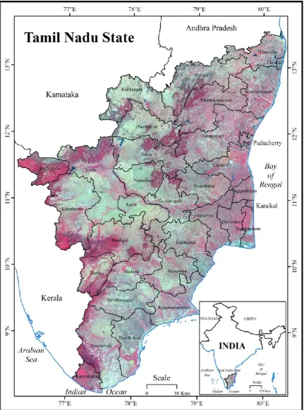
[image:2.595.86.518.178.760.2]Tamil Nadu State is situated at the south- eastern part of the Indian Peninsula bounded on the north by Karnataka and Andhra Pradesh, on the east by the Bay of Bengal, on the south by the Indian Ocean and on the west by Kerala State (Figure.1).
It lies between 8o 5’ and 13o 35’ North latitude and 76o 15’ and 80o 20’ East longitude. The total geographical area is 1, 30, 058 sq.km. The State can be divided broadly into two natural division’s viz., the eastern coastal plains and the western hilly area. The eastern plains are further subdivided
into Coromandal plains comprising the districts of
Kancheepuram, Thiruvallur, Cuddalore and Vellore; the alluvial plains of the Cauvery Delta extending over Thanjavur and a part of Tiruchirappalli districts and dry southern plains in
Madurai, Dindigul, Ramanathapuram, Sivaganga,
Virudhunagar, Tirunelveli and Thoothukudi districts. It extends a little beyond the Western Ghats in Kanyakumari district.
Tamil Nadu state has an equatorial/ tropical climate in the inland and an equatorial/ maritime climate in its coastal regions. In the inland, the temperature may go to extreme in some places, while it tends to bemoderate in the coastal areas. By and large, the average temperature for the mostparts of the state ranges between 28oC and 40oC in the summer season and between 18oC and 26oC in the winter season. In the hilly area, the maximum temperature may be as low as 26oC and the minimum temperature may go down to 3oC. The normal annual rainfall is 945 mm.
Data Process and Software Used
For the present study district-wise rainfall and temperature data from 1901 to 2009 (109 years) covering Tamil Nadu State were downloaded from India water portal website. Which includes minimum, average and maximum rainfall and temperature data in all district of Tamil Nadu State.For the study area the Advanced Wide Field Sensor (AWiFS) were downloaded from Bhuvan Website.
METHODS
The state rainfall and Temperature data (minimum, average and maximum) were processed in MS Excel. The Tamil Nadu state boundary map were purchased and its georeferenced by using ArcGIS Software finally the boundary were demarcated and converted in to shape file. The processed rainfall and temperature excel sheet were linked in to Tamil Nadu shape file based on its corresponding field.
Finally it was interpolated by Inverse Distance Weighted (IDW) method in ArcGIS software. And also the rainfall and temperature data (minimum, average and maximum) were assessed using graph analysis. In addition the Tamil Nadu state coefficient of variation in rainfall were processed by using the given formula and it was executed and it was mapped in ArcGIS software.
Mean.x =
Standard Deviation
Coefficient of Variation = *100 Mean
RESULTS AND DISCUSSION
Rainfall and Temperature
The changes in rainfall and temperature were mapped (Figure 3, 4, 5, 6 and 9, 10, 11, 12) from 1901 to 1935, 1936 to 1970, 1971 to 2009 and 1901 to 2009. The average annual rainfall and average annual temperature were mapped using ArcGIS software. The rainfall range was divided into five types, more than 2500 mm were considered as high rainfall zone. The rainfall ranges from 1500 to 2500 mm were labeled as moderate, 1000 to 1500 mm as normal, less than 750 to 1000 mm as low and less than 750 mm were considered as very low rainfall zone.
Similarly, the temperature figure was categorized into five zones. The region with more than 28oC was considered as high temperature zone, 27°Cto 28°C was named as moderate 26°C to 27°C as normal; 25°C to 26°C as low and less than 25°C temperature as very low temperature zone.
Rainfall Analysis 1901 – 2009
Figure 2 displays the 109 years of (1901 – 2009) average, minimum and maximum annual rainfall in Tamil Nadu state.
Average Annual Minimum Rainfall
The overall average minimum rainfall was 739 mm in Tamil Nadu state for the period 1901 - 2009. The deviation of annual minimum rainfall was found in all years. The rainfall range has gradually decreased. The highest average annual minimum rainfall was recorded in a few years like 1903, 1930, 1946, 1978, 1988 and 1997 particularly the maximum of 1081 mm rainfall has been received in 1988. The lowest average annual minimum rainfall was reported in 1904 (433 mm).
Average Annual Rainfall
The 109 year of average annual mean rainfall was 1214.68 mm. The maximum of rainfall was reported in 1903, 1930, 1945 and 1988. Especially the highest average b annual rainfall was noticed in 1988 (1614.03 mm). The minimum annual average rainfall was found in 1904, 1924, 1944, 1967, 1982 and 2006. However, the lowest mean rainfall was reported in 1904 (839.10 mm).
Average Annual Maximum Rainfall
Figure 2. Minimum, Average and Maximum Annual Rainfall – 1901 – 2009
[image:4.595.143.459.360.775.2]Rainfall 1901–2009
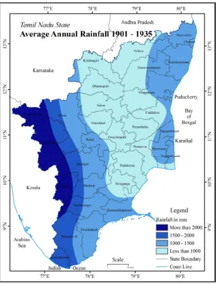
Average Annual Rainfall 1901–1935
In figure 3 the data on average annual rainfall from 1901 to 1935 are portrayed. It clearly shows that the western districts of the state namely Nilgiris and Theni, the Southern part of Coimbatore district had received the highest rainfall. Along other districts, Kanyakumari, the western part of Erode, Dindigul, Karur, Madurai and Thirunelveli received moderate rainfall, whereas the eastern part of these districts as well as the entire Thoothukudi and Ramanathapuram districts recorded normal average annual rainfall in 1901 to 1935. Similarly the eastern part of the state Thiruvallur, Chennai and
Kancheepuram districts and the eastern part of
Thiruvannamalai, Villupuram, Cuddalore, Thiruvarur and Nagapattinam district were found as normal rainfall zone. The low rainfall zone can be seen in the central parts of Tamil Nadu state covering Krishnagiri, the western parts of Dharmapuri and Salem, Namakkal, Tiruchirappalli, Pudukottai, Thanjavur and Sivaganga districts. The area under very low rainfall zone was reported in the eastern part of Dharmapuri and Salem districts of the state.
Average Annual Rainfall 1936–1970
Details on the average annual rainfall from 1936 to 1970 for Tamil Nadu state are displayed in Figure 4. The figure indicates that the western part of Nilgiris, Coimbatore and Theni districts had received the highest amount of rainfall. Kanyakumari and the western part of Erode, Dindigul, Karur, Madurai and Thirunelveli districts were covered under moderate rainfall zone. Whereas the eastern parts of these
districts as well as the entire Thoothukudi and
Ramanathapuram districts and eastern districts of the state covering Thiruvallur, Chennai and Kancheepuram and the eastern part of Vellore, Thiruvannamalai, Villupuram, Thiruvarur and Nagapattinam districts recorded normal rainfall. Pudukottai, Thanjavur and Sivaganga districts and the western part of Krishnagiri, Dharmapuri, Salem, Namakkal and Tiruchirappalli districts had low rainfall and remaining portion of these districts were found in very low rainfall zone.
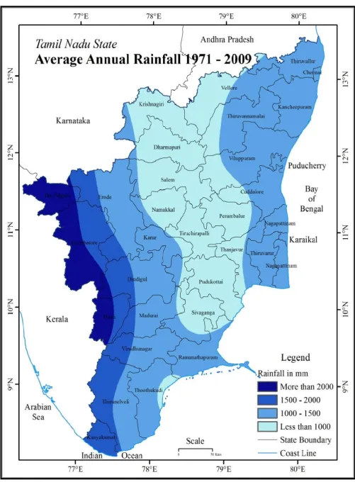
Average Annual Rainfall 1971–2009
Figure 5 represents the data on average annual rainfall from 1971 to 2009. The figure represent that the western part of Nilgiris district recorded the highest amount of rainfall. while the remaining parts of Nilgiris, entire Kanyakumari as well as western part of Erode, Dindigul, Karur, Madurai and Thirunelveli districts had received moderate rainfall; whereas the eastern parts of these districts as well as the entire Thoothukudi, Ramanathapuram and Nagapattinam districts, eastern districts of the state viz., Thiruvallur, Chennai and Kancheepuram districts and the eastern part of Vellore, Thiruvannamalai, Villupuram and Thiruvarur districts fall under the normal rainfall zone. The low rainfall zone covers entire Pudukottai, northern portion of Sivaganga, western part
of Krishnagiri, Dharmapuri, Salem, Namakkal and
Tiruchirappalli districts; the remaining areas of these districts had very low rainfall.
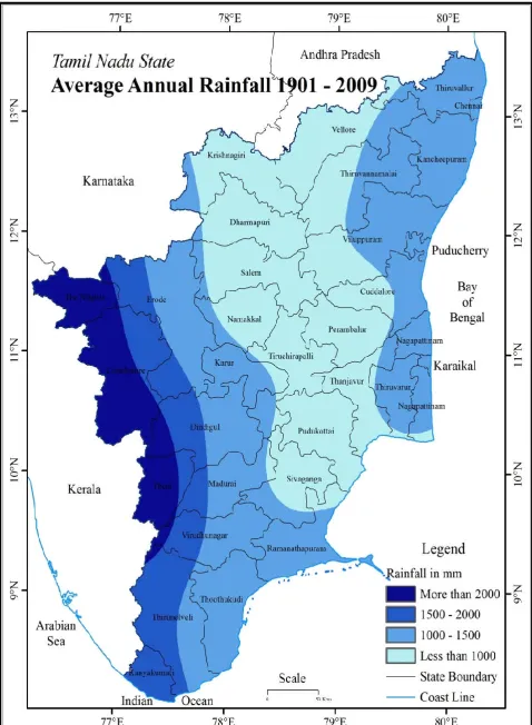
Average Annual Rainfall 1901–2009
[image:9.595.49.544.49.336.2]109 years (1901 – 2009) of average annual rainfall are shown in figure 6. It is clear from the figure that the western part of
Nilgiris district recorded highest amount of rainfall; whereas remaining areas of the district and Coimbatore, Theni, Kanyakumari and western part of Erode, Dindigul, Karur, Madurai and Thirunelveli districts received moderate rainfall. While the eastern part of these districts as well as the entire Thoothukudi and Ramanathapuram districts recorded normal rainfall. Similarly the eastern part of the state namely Thiruvallur, Chennai and Kancheepuram districts and eastern part of Vellore, Thiruvannamalai, Villupuram, Thiruvarur and Nagapattinam districts fall under normal rainfall zone. Thanjavur, Pudukottai and Sivaganga districts and the north-central districts of the state viz., Krishnagiri, Dharmapuri, Salem, Namakkal, Tiruchirappalli, Pudukottai, Thanjavur and Sivaganga districts received low as well as very low rainfall. The western districts of the state cover high and moderate rainfall zone, some parts of the Erode, Karur, Dindigul, Madurai, Virudhunagar, Thoothukudi and Ramanathapuram districts and coastal districts fall in normal rainfall zone and the central districts of the Tamil Nadu state had fallen from low rainfall zone to very low rainfall zone. On the whole, the rainfall decreased significantly since 1998.
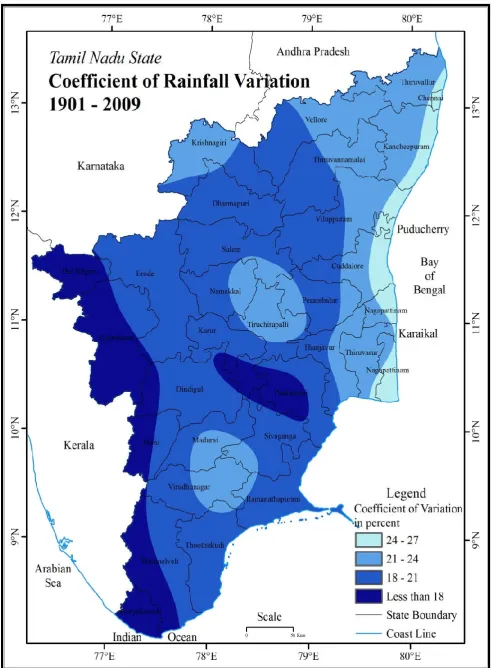
Coefficient of Variation 1901–2009
The coefficient of variation calculated for 109 years from 1901 to 2009 represented in figure 7. The figure shows that the western parts of Tamil Nadu coveringthe Nilgiris, Coimbatore, Theni, Thirunelveli and Kanyakumari districts and a small area in the western part of Dindigul and Pudukottai districts had less than 18 percent of variation.Whereas the remaining area of these districts as well as the entire Erode, Dharmapuri, Karur, Thoothukudi, Sivaganga and Ramanathapuram districts were found to have 18 to 20 percent. Kolli and Pachaimalai region, the western part of Virudhunagar, the northern part of Madurai, the western part of Krishnagiri, the eastern part of Vellore and Thiruvannamalai, western part of Thiruvallur, Kancheepuram, the central part of Thanjavur and Thiruvarur districts have 21 – 24 percent of variation. The coastal belt of Tamil Nadu, particularly Chennai, Cuddalore, Kancheepuram, Villupuram and Nagapattinam districts experienced maximum coefficient of variation. In general, the western part of the state shows very low coefficient of variation; these areas have received consistently high rainfall. It is clear that coefficient of variation in rainfall is high in the coastal districts of Tamil Nadu state, moderate in the central districts and low in the western districts.
Temperature Analysis 1901–2009
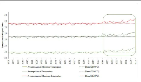
Figure 8 displays the minimum, average and maximum annual temperature in Tamil Nadu state from the year 1901 to 2009.
Average Annual Minimum Temperature
The mean average annual minimum temperature of 109 years was 21.92 °C. The fluctuation in the average annual minimum temperature from 1901 to 1979 was low. But from the year 1980 onwards it had steadily increased, the high amount of annual minimum temperature was recorded in 2009 (23.89 °C) and low annual average minimum temperature was reported in 1917 (21.72 °C).
Average Annual Temperature
The 109 year mean annual temperature was 27.04°C. The average temperature was below annual mean in all the years; however, it started increasing significantly, since 1980. The high average annual temperature was 28.49°C and the low temperature was 26.37 °C.
Average Annual Maximum Temperature
The mean maximum temperature in Tamil Nadu state from 1901 to 2009 was 31.28°C. The average annual maximum temperature was less than the mean with a few exceptions in the years 1906, 1940, 1953, 1963 and 1973. The temperature has slowly increased. Particularly from 1980, the temperature started increasing notably. The maximum temperature was recorded in 2008 (32.56°C) and the lowest maximum temperature was noticed in 1917 (30.58°C). Since 1980 onwards the average annual maximum temperature has increased. The overall increase in annual average temperature between 1901 and 2009 was 1.6oC. The increase in annual average temperature between 1901 and 1980 was 0.3oC i.e. during a period of 80 years. But it has increased by 1.3oC within the period of 29 years from 1981 to 2009. Thus, it is clear that the annual average temperature has increased rather quickly from 1980 onwards.
Temperature 1901 - 2009
Average Annual Temperature 1901–1935
Figure 9 represents the data on average annual temperature from 1901 to 1935. It shows that the northern districts covering Salem, Perambalur, Villupuram, Cuddalore and Thiruvallur districts fall under moderate temperate zone (27 - 28oC). The normal temperature zone (26 – 27oC) covers Dindigul, Karur, Pudukottai, Theni, Madurai, Sivaganga, Virudhunagar, Thoothukudi, Thirunelveli and Kanyakumari districts. And other districts fall under this zone includes Vellore, the eastern part of Thiruvannamalai and the central part of the Dharmapuri and Krishnagiri. The low rainfall zone (25 – 26oC) includes the eastern part of Nilgiris and Coimbatore districts, small area in the southern part of Vellore, the western part of Thiruvannamalai, the northern part of Dharmapuri and the eastern part of Krishnagiri districts. The area under very low temperature (less than 25oC) includes the western part of Nilgiris and Coimbatore districts of Tamil Nadu state.
Average Annual Temperature 1936–1970
This zone also includes the north-central part of the state covering Vellore district, the eastern part of Thiruvannamalai district and the central part of Tamil Nadu state. Theeastern part of Nilgiris, Coimbatore and Krishnagiri districts, the western part of Erode, the southern part of Vellore, the western part of Thiruvannamalai, the northern part of Dharmapuri districts received very low temperature.
Average Annual Temperature 1971–2009
Figure 11 portrays the average annual temperature from 1971 to 2009. The figure displays that the northern districts of Tamil Nadu viz., Krishnagiri, Salem, Perambalur, Cuddalore, Kancheepuram, Chennai and Thiruvallur, and some small portion in the eastern part of Ramanathapuram districts were located in the highest temperature zone. The area under moderate temperature zone covers the southern districts of the state namely Dindigul, Karur, Pudukottai, Theni, Madurai, Sivaganga, Virudhunagar, Thoothukudi, Thirunelveli and Kanyakumari. It also covered small portions in the north-central part of the state. Moderate temperature was noticed in a few places in Vellore, Thiruvannamalai, Dharmapuri and Erode districts of the state. The western part of state covering the Nilgiris and Coimbatore districts are in the low temperature zone.
Average Annual Temperature 1901–2009
The data on average annual temperature of 109 years are portrayed in figure 12. It shows that the western part of Krishnagiri district is in the highest temperature zone. Eastern districts of the state viz., Thiruvallur, Chennai, Kancheepuram and Cuddalore, northern part of the state covering Salem, Perambalur, Villupuram districts and south-eastern part of Ramanathapuram, some small regions in the southern part of the Dindigul district and Sivaganga districts fall under the moderate temperature zone. The area under normal temperature includes the southern districts such as Erode, Karur, Pudukottai, Theni, Madurai, Sivaganga, Virudhunagar, Thoothukudi, Thirunelveli and Kanyakumari; and the north-central part of the state namely, Vellore, Thiruvannamalai, Dharmapuri districts. The Nilgiris and Coimbatore districts, the southern part of Vellore, the western part of Thiruvannamalai, the northern part of Dharmapuri and the eastern part of Krishnagiri districts were in low temperature zone in the state. The western districts fall under low temperature zone, coastal, northern and a part of Ramanathapuram and Sivaganga districts were in moderate temperature zone. Southern, central and north central districts experienced near normal temperature. The districts are slowly moving from lower temperature zone to higher temperature zone.
Conclusion
The present study concludes, On the whole - the rainfall figures show the western districts of the state are under high and moderate rainfall zone, coastal districts fall in normal rainfall zone and the central districts of the state are in low rainfall zone to very low rainfall zone. The coefficient of variation reveals that the western part of the state has very low to low coefficient of variation; while it is high in the coastal districts of Tamil Nadu state, moderate in the central districts. From the study, it is found that there is decreasing trend in average, minimum and maximum annual rainfall starting from 1998 onwards in Tamil Nadu state. The annual average temperature between 1901 and 2009 was 1.6oC. The increase in annual average temperature between 1901 and 1980 was 0.3oC i.e. during a period of 80 years. But it has increased by 1.3oC within a period of 29 years from 1981 to 2009, thus, the annual average temperature has increased rather quickly since 1980 onwards. According to the temperature figure the western districts fall under low temperature zone, coastal and the northern districts were in the moderate temperature zone. The southern, central and north central districts experienced near normal temperature. In general, Tamil Nadu State is slowly moving from lower temperature zone to higher temperature zone.
Acknowledgement
I would like to thank to the Jawaharlal Nehru Memorial Fund Scholarship (SU – A/111 /2011-12/399, Dated: December 09, 2010), New Delhi for their financial support and Authorities of the Gandhigram Rural Institute –Deemed University and Centre for Geoinformatics Application on Rural Development (C-GARD), National Institute of Rural Development and Panchayati Raj (NIRD & PR) for their administrative support.
REFERENCES
Hingane, L. S., Rupa Kumar, K. and Ramanamurthy, B. V. 1985. “Long Term Needs of Surface Air Temperature in India”, International Journal of Climatology, Vol.5, pp 521-528. Intergovernmental Panel on Climate Change, IPCC - 2007a.
http://www.ipcc.ch/index.htm.
IPCC, 2007b. “Fourth Assessment Report (AR4)”. http://www. ipcc.ch/publicationsaand_data/publicationsipcc_fourth_assess ment_report_synthesis_report.htm.
Satellite Images, National Remote Sensing Centre (NRSC) Bhuvan, http://bhuvan.nrsc.gov.in/data/download/index.php State Level Rainfall and Temperature Data, India water portal),
http://indiawaterpo rtal.org/met_data/
Thapliyal, V. and Kulshreshtha, S. M. 1991. “Climate changes and Trends Over India”, Mausam, Vol.42, pp 333–338.