AUTHOR(S):
SIGNATURE(S):
YEAR OF WORK:
PROPERTY NAME:
CLAIM NAME(S) (on which the work was done):
COMMODITIES SOUGHT:
MINERAL INVENTORY MINFILE NUMBER(S), IF KNOWN:
NTS/BCGS:
LONGITUDE:
o
'
1)
2)
OPERATOR(S) [who paid for the work]:
1)
2)
MAILING ADDRESS:
TYPE OF REPORT [type of survey(s)]:
TOTAL COST:
Ministry of Energy, Mines & Petroleum Resources
Mining & Minerals Division
BC Geological Survey
Assessment Report
Title Page and Summary
(at centre of work)
MAILING ADDRESS:
Next Page
John Biczok
NOTICE OF WORK PERMIT NUMBER(S)/DATE(S):
5766816
, Dec. 10, 2019
STATEMENT OF WORK - CASH PAYMENTS EVENT NUMBER(S)/DATE(S):
201
9
BOULDER PROPERTY (ANDREI NORTH CLAIMS)
#1066899 and ANDREI NORTH 3, #1066909
Copper,
gold,
zinc
N/A
B
104
G
.007, 104G.017
Liard
MINING
DIVISION:
LATITUDE:
OWNER(S):
06 '
44
46
Romios
Gold
Resources
Inc.
(McLymont
Mines
Inc.(146096))
Romios Gold Resources Inc.
2 Toronto St., Suite 500, Toronto, ON M5C 2B6
GEOLOGICAL
$
10,234.76
PROPERTY GEOLOGY KEYWORDS (lithology, age, stratigraphy, structure, alteration, mineralization, size and attitude):
"Stikine Assemblage" Devonian limestone quartzite boulders copper zinc
2 Toronto St., Suite 500, Toronto, ON M5C 2B6
REFERENCES TO PREVIOUS ASSESSMENT WORK AND ASSESSMENT REPORT NUMBERS:
Watkins, J.J., Melling, D.R., and Mirko, J., 2007. Assessment report on ...the Foremore Property. Assessment report # 29475
Melling, D.R., and Albers, P.B., 2008. Report on 2008 Fieldwork... Foremore Property, NW BC Assessment report #3042
Gunning, D.R., 1997. Geological investigation of the Antler property. Assessment report #24918 on behalf of Westore
Engineering.
57
o
"
131
40
"
"
BC Geological Survey
Assessment Report
GEOLOGICAL (scale, area)
Ground, mapping
Photo interpretation
GEOPHYSICAL (line-kilometres)
Ground
Magnetic
Electromagnetic
Induced Polarization
Radiometric
Seismic
Other
Airborne
GEOCHEMICAL
(number of samples analysed for...)
Soil
Silt
Rock
Other
DRILLING
(total metres; number of holes, size)
Core
Non-core
RELATED TECHNICAL
Sampling/assaying
Petrographic
Mineralographic
Metallurgic
PROSPECTING (scale, area)
PREPARATORY / PHYSICAL
Line/grid (kilometres)
(scale, area)
Legal surveys (scale, area)
Road, local access (kilometres)/trail
Topographic/Photogrammetric
Trench (metres)
Underground dev. (metres)
TYPE OF WORK IN
THIS REPORT
EXTENT OF WORK
(IN METRIC UNITS)
ON WHICH CLAIMS
PROJECT COSTS
APPORTIONED
(incl. support)
(scale, area)
Line/grid (kilometres)
PROSPECTING (scale, area)
Metallurgic
Mineralographic
Petrographic
Sampling/assaying
Non-core
Core
Other
Rock
Silt
Soil
Airborne
Other
Seismic
Radiometric
Induced Polarization
Electromagnetic
Magnetic
Photo interpretation
Ground, mapping
$354.41
#1066899 and #1066909
4
7 (incl a standard)
$
9,880.35
1:
7,5
00.
~
1
sq
km
#1066899 and
ANDREI NORTH 3, #1066909
REPORT ON THE 2019 SUMMER EXPLORATION PROGRAM
on the
BOULDER (ANDREI NORTH) CLAIMS
on behalf of
ROMIOS GOLD RESOURCES INC.
Liard Mining Division
NTS 104G 02
BCGS 104G 007 and 104G 017
57° 6’ 44” North Latitude
131° 46’ 40”’ West Longitude
Field work Date: July 19th, 2019
Prepared For:
ROMIOS GOLD RESOURCES
2 Toronto St., Suite 500,
Toronto, ON, M5C 2B6
Prepared By: John Biczok, H.B.Sc., P.Geo.
March 15, 2020
Table of Contents
TABLE OF CONTENTS ... II
1
SUMMARY ... 1
2
INTRODUCTION ... 3
3
PROPERTY DESCRIPTION AND LOCATION ... 3
4
ACCESSIBILITY, CLIMATE, PHYSIOGRAPHY AND INFRASTRUCTURE ... 5
5
HISTORICAL WORK ... 6
6
GEOLOGICAL SETTING ... 7
6.1
REGIONAL
GEOLOGY ... 7
6.2
BOULDER
CLAIMS
GEOLOGICAL
MAPPING
&
PROSPECTING
2019 ... 9
6.2.1
UNIT DESCRIPTIONS... 9
7
SAMPLING PROCEDURE AND QAQC ... 11
7.1.1
SAMPLING AND ASSAY PROCEDURES ... 11
7.1.2
SAMPLE SECURITY ... 12
7.1.3
QAQC PROCEDURES ... 12
7.1.4
QAQC RESULTS ... 12
8
MINERALIZATION ... 13
9
CONCLUSIONS ... 14
10
RECOMMENDATIONS ... 14
11
REFERENCES ... 15
12
STATEMENT OF EXPENDITURES ... 16
13
AUTHOR’S CERTIFCATE ... 16
LIST OF FIGURES
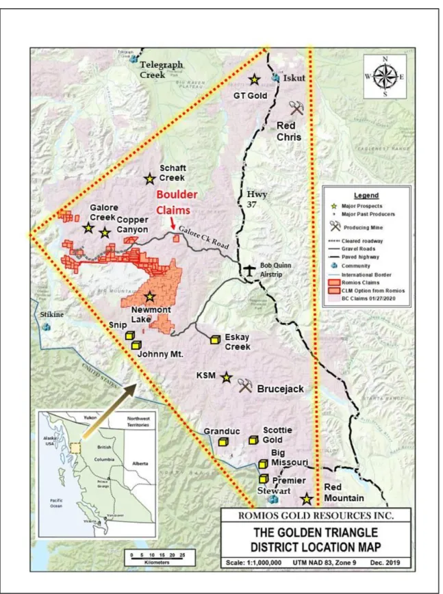
Figure 1: Location map of the Boulder Claims within the Golden Triangle ... 2
Figure 2 : Claim location map of the northern Golden Triangle ... 4
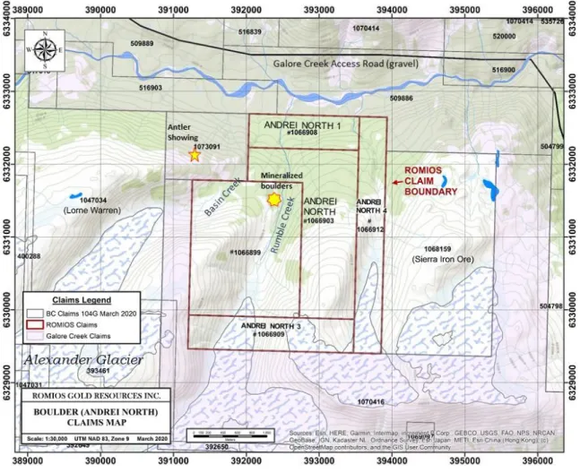
Figure 3 : Claim map of the Boulder (Andrei North) claims area ... 5
Figure 4: Location of the Boulder (Andre North) Claims on Satellite Image ... 8
Figure 7: Copper analyses of standard OREAS 504B ... 21
Figure 8: Gold analyses of standard OREAS 504B ... 21
Figure 9: Copper analyses of standard OREAS 505 ... 22
Figure 10: Gold analyses of standard OREAS 505 ... 22
LIST OF MAPS
Map 1: Geological mapping and stop locations 2019 ... 10
Map 2: Sample locations and assay results on satellite image ... 13
LIST OF TABLES
Table 1 : Summary of claim details, Boulder (Andrei North) claims ... 4
LIST OF APPENDICES
APPENDIX ONE: QAQC Results Charts and Discussion ... 18
APPENDIX TWO: Descriptions of Geological Mapping Stop Descriptions ... 24
APPENDIX THREE: Sample descriptions and assay results ... Appended
APPENDIX FOUR: Assay certificates ... Appended
1 SUMMARY
This report presents the results of the 2019 exploration field program carried out by a
crew from Romios Gold Resources Inc. on the company’s five “Boulder” (Andrei North)
claims in the east-central part of the “Golden Triangle” in northwestern British Columbia
(Fig. 1). The field work was conducted by a four-person geological crew July 19
th
, 2019.
The claims are located 40 km east of the giant Galore Creek Cu-Au alkalic porphyry
deposits, 29 km east of Highway 37, and just 850 m south of the gravel access road from
Highway 37 to the proposed Galore Creek mill site in the “Round Lake” area. (Figs. 2 and
3). The local stratigraphy consists predominantly of lower to middle Devonian limestone,
quartzite and lesser basalt of the Stikine Assemblage. These strata are intruded along
the eastern side of the claims by granitoid rocks of the Early Mississippian More Creek
pluton. Mineralization in the area includes the porphyry Cu-Au deposits at Galore Creek,
Copper Canyon and Schaft Creek plus numerous smaller prospects.
The goal of the 2019 Romios exploration program was to undertake reconnaissance scale
mapping and prospecting along the N-S valley in which mineralized boulders had been
reported by earlier workers and attempt to locate the source of any such boulders now
that the glacier in this valley had receded substantially in recent years.
The 2019 program included geological mapping during a pair of 2-man traverses,
primarily on the westernmost claims, and a helicopter-borne visual examination of the
extensive bare outcrops that underlie much of the western claims in an effort to locate
any obvious signs of mineralization. No indications of significant mineralization were
located although several weakly mineralized boulders were found and a magnetic high at
the western margin of the More Creek pluton and the limestone dominated stratigraphy
remains of interest.
2 INTRODUCTION
Romios Gold Resources Inc.
(the “Company” or “Romios”) through its wholly owned
subsidiary McLymont Mines Inc. owns outright the five Andrei North claims in the “Golden
Triangle” area of northwestern British Columbia (Figs. 1, 2, 3). The claims were staked
online by Romios on March 1, 2019 and are referred to internally as the “Boulder claims”.
The 2019 exploration work consisted of one day of field mapping, prospecting and
sampling by a four-man Romios geological team on July 19th (see Sec. 12: “Statement
of Expenditures” for personnel and dates worked). This work was focussed along the
north-south glacial valley in the western half of the claims where several mineralized
boulders had been reported by previous explorers. A helicopter-borne aerial
reconnaissance of the largely bare valley walls was conducted in a search for any signs
of mineralization without success prior to undertaking traverses on foot along the valley
floor.
The sampling procedures as well as the QAQC protocols and results are discussed in
Chapter 7 and presented in more detail in Appendix One. Descriptions of each geological
mapping stop are presented in Appendix Two and sample descriptions with the principal
assay results are given in Appendix Three. Assays results are appended as Appendix
Four; these assay certificates include numerous samples from other Romios claims
collected during the summer program.
3 PROPERTY DESCRIPTION AND LOCATION
The five Boulder (Andre North) claims, referred herein as the
“Boulder” claims, in the
“Golden Triangle” area of northwestern British Columbia are owned 100% by McLymont
Mines Ltd, a wholly owned subsidiary of Romios Gold Resources Inc. (Table 1, Fig. 3).
The claims were acquired by online staking March 1, 2019 and cover an area of 790.8
Ha. The western claim boundary is approximately 40 km east of the Galore Creek Cu-Au
deposits, the eastern boundary is 29 km west of provincial Highway 37 and the northern
boundary is less than 1 km south of the gravel access road from Highway 37 to the
proposed Galore Creek mill site (Figs. 2, 3). The claims are within the Liard Mining
Division on NTS map sheet 104G 02 and BCGS map sheets 104G 007 and 104G 017.
Table 1 : Summary of claim details, Boulder (Andrei North) claims
Title
Number
Claim Name
Owner
Issue Date
Good To
Date*
Area
(ha)
1066899
McLymont Mines Inc.
(100%)
2019/MAR/01
2021/MAR/01
281.18
1066903
ANDREINORTH
McLymont Mines Inc.
(100%)
2019/MAR/01
2021/MAR/01
210.87
1066908
ANDREI NORTH1
McLymont Mines Inc.
(100%)
2019/MAR/01
2021/MAR/01
70.27
1066909
ANDREINORTH3
McLymont Mines Inc.
(100%)
2019/MAR/01
2021/MAR/01
105.47
1066912
ANDREINORTH4
McLymont Mines Inc.
(100%)
2019/MAR/01
2021/MAR/01
123.01
* Upon acceptance of this report
Total Ha
790.81
Figure 3 : Claim map of the Boulder (Andrei North) claims area
.
4 ACCESSIBILITY, CLIMATE, PHYSIOGRAPHY AND
INFRASTRUCTURE
The Boulder (Andrei North) claim block is accessible by helicopter from several points,
the nearest public site being the Bob Quinn airstrip 35 km to the ESE on Provincial
highway #37 (Fig. 2). The claim is ~40 km east of the giant Galore Creek porphyry
Cu-Au deposits which are currently undergoing efforts by the owners, a Teck - Newmont JV,
to advance the project to the pre-feasibility stage. Several construction camps and
laydown areas are situated along the proposed and partially completed mine access road
from Highway 37 along the creek immediately north of the Boulder claims and thence
along Sphaler Creek towards Galore Creek. The GCMC Ch’iyone camp is just 9 km SE
of the Boulder claims. Access for the brief program described in this report was by
helicopter from the Crystal Lake Mining (CLM) exploration camp on Romios’ Newmont
Lake claims (some of which are now under option to CLM), located ~20 km to the SSW
(Fig. 2).
The climate of the area varies strongly with the elevation, which ranges from less than
900 m ASL in the heavily forested river valley immediately north of the claims to >1700 m
in the bare SE corner of the claims. The southern portion of the claim block examined
during this program is above treeline and only locally covered with grasses and the
occasional small shrubs; much of it appears to have been only recently exposed by
melting of the glacier at the (southern) head of the valley. Thick forests of spruce and
hemlock cover the lower elevations north of the area traversed. The nearest BC weather
station with available historic climate data is at Telegraph Creek. Monthly average
temperatures there range from daily maximums and minimums of -10.5
˚
C and -18.1
˚
C
in January to 21.9
˚
C and 7.5
˚
C in July.
5 HISTORICAL WORK
The project area was mapped by J.G. Souther (1971) of the Geological Survey of Canada
at a scale of 1:250,000 as part of the Telegraph Creek (104G) mapsheet; he noted
Mississippian limestone in the western claims area and “post upper-Triassic” granodiorite
in the east. The area was included in the extensive 1:100,000 scale mapping by Logan
et al
in 2000 and several outcrops on the southern ridges were mapped as lower and
middle Devonian limestone (based on a conodont age date) while the large batholith
along the eastern side of the clams was included in the early Mississippian (~355 Ma)
More Creek plutonic suite (granite to diorite). Neither of these mapping programs appear
to have conducted detailed mapping in the main valleys.
Past exploration work in the immediate claims area was focussed on the “Antler” prospect
which lies on a small claim owned by GCMC adjacent to the NW corner of the Boulder
claims (Fig. 3). According to the BC Minfile and various assessment report descriptions,
the Antler area
is underlain Devonian Stikine Assemblage lithic tuffs, compositionally
layered rhyolite, rare phyllite, sericite, and quartz-sericite schist and limestone; some of
these units are silicified at a pyrite-rich mineralized showing was discovered here in 1992.
The area contains a large rhyolite dome nearby. A soil geochemical survey by Cominco
in 1989 over a part of the area failed to produce any anomalies,
In 1995 and 1996, Westore Engineering undertook a brief mapping and sampling program
over the “Broken Antler” prospect as well as the valley of “Rumble Creek”, ~900 m to the
SE (on the current Romios claims, Figs. 3, 4). Sulphide-rich boulders located in Rumble
Creek assayed up to 11.9 per cent zinc and 0.57 per cent copper with anomalous arsenic
(Gunning, 1997).
In 2007 Roca Mines personnel collected and analyzed 17 grab samples from outcrops of
pyrite-rich material hosted in a super-siliceous rhyolite breccia at the Antler prospect - all
yielded very low base metals, low silver with molybdenum <58 ppm and a high of only
0.17 gram per tonne gold. Both arsenic and antimony were elevated, up to 3,808 ppm As
and 193 ppm Sb, in the pyrite rich samples. (Watkins et al, 2007).
In 2008, in the Antler area, gridding, mapping, magnetometer and IP surveys were
completed and a mineralized basalt sample which assayed 0.6% Cu was collected on the
“north side of Rumble Creek” (Melling and Albers, 2008),
Romios Gold Resources Inc. has not conducted in work on the Boulder claim area prior
to 2019.
6
GEOLOGICAL SETTING
6.1 REGIONAL GEOLOGY
The Boulder claims lie along the ~N-S contact between granitic rocks of the Mississippian
More Creek pluton to the east and intercalated volcanic and sedimentary strata of the
Devonian Stikine Assemblage to the west (Fig. 4). The BCGS digital geology map
Figure 4: Location of the Boulder (Andre North) Claims on Satellite Image with BCGS regional
geological contacts and 2019 mapping stops (Map 1 for Stop #s)
indicates that the Stikine assemblage here is largely mafic volcanics, however, mapping
by Souther (1971), Logan et al (2000), and the Romios crew in 2019 all located primarily
limestone outcrops with lesser quartzite and only rare outcrops of basalt. These strata
trend roughly north-south and dip shallowly to moderately to the west. The granitic rocks
on the east side of the claim are shown as part of the late Devonian (~370 Ma) Forrest
Kerr plutonic suite in the BCGS digital map, however, Logan
et al
(2000) age dated this
intrusion at 357 Ma and placed it in the Mississippian More Creek plutonic suite. The latter
authors identified granitic to dioritic phases in this pluton.
6.2 BOULDER CLAIMS GEOLOGICAL MAPPING & PROSPECTING 2019
Outcrops mapped by the Romios crew on the Boulder claims in 2019 are depicted below
on Map 1. Sample locations and assay results are presented on Map 2. Descriptions of
the geology at each stop are given in Appendix Two. The individual units mapped in 2019
are described below.
Before traversing the Rumble Creek valley, a helicopter-borne visual inspection of both
valley walls was conducted in an effort to locate visible signs of mineralization, especially
in the southern parts of the valley which have only been recently exposed by the receding
glacier. No obvious mineralization was noted. The eastern side of the valley was noted to
be a very steep mountainside, composed of barren (?) granitic outcrops, and hidden along
its base by thick accumulations of glacial till, ice and snow. For this reason traversing was
conducted primarily down the centre and along the west side of the valley.
6.2.1 UNIT DESCRIPTIONS
MUDSTONE / SILTSTONE: A light purple mudstone of the Stikine Assemblage was
located at Stop JB-19-5b. The mudstone is thinly bedded and grades into the adjacent
quartzite beds over 1-2 m. It is folded into a series of well-developed open folds with a
5-6 m wavelength. The fold axes trend 140 deg. and plunge 20 deg. to the SE.
LIMESTONE: This is the predominant unit exposed along the west side of Rumble Creek
valley. It is generally white to off-white and thinly laminated to thick bedded and forms
prominent ledges tens of metres high along the west side of the valley. No macroscopic
fossils were observed in it during this program. It is cut by local patches of pervasive
brown iron carbonate alteration and veins up to 2 m wide.
QUARTZITE: This unit overlies at least one limestone horizon along the west side of
Rumble Creek valley and is a typical fine grained, ~massive, featureless siliciclastic unit
with local minor pyritic patches.
MAFIC DYKES: One basaltic dyke was observed to cut the limestone at Stop JB-19-1.
The dyke is 1 m wide and strikes 135 deg. No obvious mineralization or skarnification
was observed along the dyke margins.
BASALT: One outcrop of possible basalt was located at Stop IR-19-3. The unit is dark
grey-green, very fine-grained to aphanitic, and massive. It is cut by minor siderite veins
and local trace malachite and is r intercalated with lesser light grey-purple, siltstone.
7 SAMPLING PROCEDURE AND QAQC
7.1.1 SAMPLING AND ASSAY PROCEDURES
During the course of the field work described herein the only samples collected on the
Boulder claims were 6 rock samples (Map 2) (which were assayed for gold +/- a
multi-element analyses); no stream sediment or soil samples were collected. The rock samples
were either grab samples of various rock types or chip samples across the full widths of
several quartz veins as described in Appendix Two. Samples were collected by hand with
small sledge hammers as well as rock chisels where necessary. Samples were put into
laboratory supplied thick plastic bags along with a sample tag and then secured with either
a zip tie or tightly wound flagging tape.
Samples were analyses at the ALS laboratories in Terrace and Vancouver B.C. utilising
their standard gold assay procedure Au-ICP 21 and their 48 element ME-MS61 analytical
package which includes an initial four acid digestion followed by inductively-coupled
plasma–atomic emission spectrometry (ICP-AES) and inductively-coupled plasma–mass
spectroscopy. The gold assay protocol includes a flux digestion followed by fire assay
and an ICP-AES finish. A prepared sample is fused with a mixture of lead oxide, sodium
carbonate, borax, silica and other reagents as required, inquarted with 6 mg of gold-free
silver and then cupelled to yield a precious metal bead. The bead is digested in 0.5 mL
dilute nitric acid in the microwave oven. 0.5 mL concentrated hydrochloric acid is then
added and the bead is further digested in the microwave at a lower power setting. The
digested solution is cooled, diluted to a total volume of 4 mL with de-mineralized water,
and analyzed by inductively coupled plasma atomic emission spectrometry against
matrix-matched standards.
7.1.2 SAMPLE SECURITY
Once brought into the camp from the field, samples were put in polyweave plastic rice
bags secured with zip ties and hidden from view within the crew’s tent until delivered in
person to the ALS laboratory in Terrace by either the author or the senior crew member,
Mr. Jim Edwards, P.Geo.
7.1.3 QAQC PROCEDURES
Given the small number of samples collected during this particular one day field program
they were included in a larger batch shipment to the laboratory used for Romios’ summer
exploration program in the Golden Triangle, the ALS laboratory in Terrace, B.C. As a
matter of protocol, typically every 10
th
sample was either a blank (sourced from a local
barren granite) or
a commercial standard from OREAS. (Romios’ entire 2019 field
program, including the samples collected on the Boulder claims, resulted in 165 rock
samples sent for analysis with 9 blanks and 8 standards). The most suitable standard
inserted into a particular series of samples was selected from a number of available
standards on hand based on the expected range of copper and gold levels in the field
samples in that series.
7.1.4 QAQC RESULTS
Results of the gold and copper assays and analyses of the granite blanks and standards
used by Romios in the 2019 program were graphed and compared to the accepted
average value and upper and lower tolerance thresholds. Overall the results of the QAQC
program indicate that there were no significant issues with sample security or the
accuracy of the analytical laboratory. Complete results from all blanks and standards are
presented in Appendix One.
8 MINERALIZATION
The Boulder (Andrei North) claims were staked by Romios based on historic reports from
previous exploration programs that Cu-Zn mineralized boulders had been located along
rumble Creek in the mid-1990s and again later in 2008 (Figs .3 and 4).
Map 2: Sample locations and assay results on satellite image
Mapping and sampling in the upper (southern) portion of Rumble Creek failed to locate
any significantly mineralized boulders or outcrops. The highest assay, 0.2% Cu, came
from a small malachite stained outcrop of basalt and intercalated siltstone at Stop
IR-19-03. A sample of massive magnetite (skarn?) float, A0602502, located at Stop JB-19-06,
proved to be barren. A single large boulder of bright red jasper with several quartz veinlets
(sample A0602503) at Stop JB-19-08, returned anomalous levels of copper, 490 ppm.
One goal of this program was to examine the contact of the More Creek pluton along its
western contact with the limestone and other sedimentary and volcanic strata in an effort
to locate potential skarn mineralization. Unfortunately this contact is obscured by thick
glacial till and semi-permanent ice banks along the eastern side of the valley where
traversed in 2019. It is conceivable that the contact area is exposed farther north.
9 CONCLUSIONS
No indications of significant
in situ
alteration or mineralization were located during the
2019 exploration program on the Boulder claims nor were any well mineralized boulders
located during this brief program. However, the area mapped and prospected in 2019 is
south of the documented location of well mineralized Cu-Zn bearing boulders. No
significant granitic or syenitic intrusions were observed to cut the sedimentary strata
(other than the More Creek pluton to the east). It is still conceivable that the mineralized
boulders discovered by previous workers are related to a VMS producing rhyolite horizon
located north to northwest of the area mapped in 2019.
10 RECOMMENDATIONS
Further mapping and prospecting north of the area examined in 2019 is recommended in
an effort to locate the source of the Cu-Zn mineralized boulders discovered by previous
workers. Examination of the postulated limestone-granite contact for evidence of skarn
mineralization north of the 2019 mapping is also recommended.
Respectfully Submitted,
John L. Biczok, H.B.Sc., P.Geo.
March 15, 2020
11 REFERENCES
Gunning, D.R., 1997. Geological investigation of the Antler property. Assessment report
#24918 on behalf of Westore Engineering.
Logan, J.M., Drobe, J.R. and McLelland, W.C., 2000. Geology of the Forrest Kerr-Mess
Creek Area, Northwestern British Columbia. British Columbia Ministry of Energy and
Mines, Geological Survey Branch, Bulletin 104.
Melling, D.R., and Albers, P.B., 2008. Report on 2008 Fieldwork, Geology, Soil
Geochemistry, Geophysics and Drilling, Foremore Property, Northwestern British
Columbia. Assessment report #30426 on behalf of Roca Mines. 527 p.
Souther, J.G. (1971): Telegraph Creek Map Area, British Columbia; Geological Survey of
Canada Paper 71-44.
Watkins, J.J., Melling, D.R., and Mirko, J., 2007. Assessment report on Geological,
Geochemical, prospecting and other Work on Portions of the Foremore Property.
Assessment report # 29475 on behalf of Roca Mines Inc., 116 p.
12 STATEMENT OF EXPENDITURES
The total expenses for the field work on the Boulder (Andrei North) claims, including a
pro-rated share of joint crew expenses (flights, hotels, expense account travel, field and
assay supplies), plus report writing and preparation time is
$10,234.76
.
Costs are
itemised in the table below and apportioned to the 2 claims based on the % of time and
work spent on each.
COST STATEMENT - BOULDER (ANDREI NORTH) CLAIMS 2019
ITEM
UNITS
COST/UNIT
TOTAL COST
Comments
LABOUR (Field Work)
John Biczok, P.Geo.
1
$500.00
$500.00
July 19th, 2019
Jim Edwards, P.Geo.
1
$500.00
$500.00
July 19th, 2019
Isaac Riddle
1
$450.00
$450.00
July 19th, 2019
Sean Hicks
1
$400.00
$400.00
July 19th, 2019
HELICOPTER
Interior Helicopters Charges
2.1
$1,550.00
$3,255.00
Flight from/to CLM camp
Fuel (supplied by HEG)
2.1
$227.08
$476.87
171 L/hr @ $1.33/L
Accommodation at CLM Camp
4
$200.00
$800.00
ASSAYS
Au and multi-element analysis,
incl prep and 1 standard
7
$50.63
$354.41
Shared Travel, truck rental &
misc expenses*
1
$1,498.48
$1,498.48
1/22 of travel, weather
days & misc exp.
Planning & Prep - J. Biczok and
J. Edwards
1
$500.00
$500.00
In camp literature and data
review & prep
Report Writing -
J. Biczok
3
$500.00
$1,500.00
TOTAL with Assays
$10,234.76
80% on 1066899
$8,187.81
20% on 1066909
$2,046.95
* Shared travel expenses (hotels
and flights, gas, meals, labour costs
etc.) plus camp days labour and
accom, misc. field and assay costs
divided by the number of field days
APPENDIX ONE:
QAQC RESULTS
Graphs of the gold and copper analytical results of the granite blanks and standards used
by Romios in the 2019 program are presented below along with the accepted range of
values for each of the two standards used (OREAS 504B and 505). The interval between
specific standards and blanks where the various samples from the BOULDER claims lie
are indicated on the graphs as well. Complete results from all blanks and standards are
included in the assay certificates presented in Appendix Three.
BLANKS
:
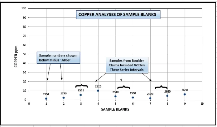
All granite blanks returned negligible gold values of 0.001 ppm or lower (Fig.
5), indicating that there was no contamination of gold levels in the laboratory crushing or
analytical procedures. Copper values were also very low and insignificant, ranging from
1.4 ppm to 9.7 ppm (Fig. 6). In terms of the other base and precious metal values, only
blank sample A0602520 returned slightly elevated levels: 4.5 ppm Ag, 9.7 ppm Cu and
41.6 ppm Pb whereas the other blanks returned negligible values. The 2 standards before
and after this blank, A0602510 and A0602530, were at or below the accepted levels for
Au and Cu, suggesting that the elevated results from blank A0602520 were spurious,
likely due to a few sulphide grains in the granite sample.
Figure 6: Copper analyses of sample blanks
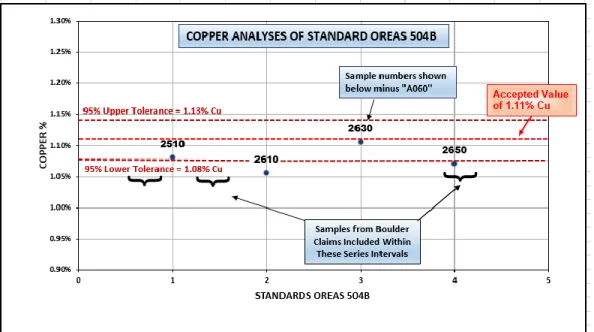
STANDARDS:
Two powdered rock standards produced by the Australian firm OREAS
were utilised in this program, OREAS 504B and 505. Results of the copper and gold
analyses of each standard are presented below along with the accepted average values
and maximum and minimum acceptable ranges. Certificates listing the accepted value
and upper and lower tolerance levels for each standard are available on the OREAS
website at
https://www.ore.com.au/
.
Copper values for the four samples of Standard OREAS 504B all fall within or slightly
below the acceptable ranges (Fig. 7) with the lowest value coming from sample A0602610
which is 0.055% below the accepted average. This minor discrepancy, while not ideal, is
insignificant in the overall picture of the 2019 sampling program. If this was a focussed
sampling program of a potential alkalic porphyry ore zone one might consider re-assaying
the samples within the influence of that particular standard.
Figure 7: Copper analyses of standard OREAS 504B
The gold assays of the four OREAS 504B standards all lie within the 95% tolerance
ranges provided by the supplier (Fig. 8).
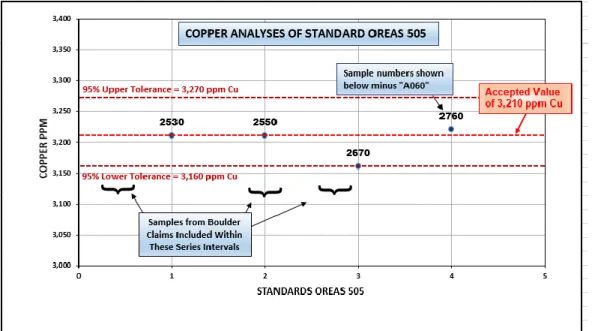
Copper analyses of the four OREAS 505 Standards also lie within the acceptable ranges
provided by the supplier and 3 of the 4 are either the same value as the accepted average
or very close to it (Fig. 9).
Figure 9: Copper analyses of standard OREAS 505
Gold assay results of the four OREAS 505 standards (Fig. 10) all lie outside the 95%
tolerance levels for this standard as stated by the supplier; one sample – A0602760 - was
slightly above the upper tolerance whereas the remaining three are all below the lower
threshold. Although not ideal, the three low values are
≤ 11 ppb Au below the lower
threshold and
≤ 15 ppb Au below the accepted average value. This discrepancy is not
considered significant in the scope of a regional sampling program.
Overall the results of the QAQC program indicate that there were no significant issues
with sample security, contamination or the accuracy of the analytical laboratory.
APPENDIX TWO: DESCRIPTIONS OF
GEOLOGICAL MAPPING STOPS
STOP
Easting
Northing
Elev
Rock Type
Description
Sample
Fol'n Strike Fol'n Dip
Bedding
Strike
Bedding
Dip
Vein/dike/struc
ture/ other
strike
Vein/dike/structur
e/ other dip
JB-19-1
392125
6330836
1143
Limestone
Limestone ridge along base of mountain side, west
side of valley. Qtzite starts ~20-30m above.
A0602501
(nearby)
JB-19-2
392080
6330430
1143
Limestone
Small, low o/c of f.g massive Lst with dense brown
frax.
JB-19-3
392044
6330371
1143
Quartzite
Small o/c, minor Py
JB-19-4
392075
6330300
1143
Quartzite
Large outcrop >50 across of quartzite, minor small
Py patches. Overlies the Limestone
JB-19-5
392082
6330200
1143
Quartzite
Typical f.g. quartzite. In contact with purple
mudstone at south end.
JB-19-5b
392076
6330190
1143
Mudstone-Quartzite
Contact
~sharp contact between quartzite to north and 6m
of purple mudstone to the south Fold in mudstone
at 140 deg plunging 020
155
80
JB-19-6
392050
6330050
1143
granodiorite
boulders
Hi % of Hbl granodiorite boulders here. Found
boulder of solid magnetite, 20cm.
A0602502
JB-19-7
391906
6329616
1217
granodiorite
boulders
Cluster of very Epi'd granodiorite boulders.
JB-19-8
391834
6329487
1215 Jasper boulder Jasper boulder, minor f.g. Py blebs
A0602503
JB-19-9
391751
6329793
1202
Qtz vein
10 cm open space Qtz x'l vein in a diorite boulder.
A0602504
JE-19-001
392045
6330619
1180
Quartzite
Recrystallized aphanitic trending N/S 30m long 15-20m wide
Pyrite Stringers, Rusty. Strongly fractured seams 20% Py
A0602551
240
90
135
35
IR-19-01
392106
6330838
NA
Quartzite
Quartzite, white, massive
338
65
IR-19-02
391960
6330747
NA
Siderite
Siderite alteration zone, presumably of limestone protolith. Local
Fe staining.
IR-19-03
391951
6330570
NA
Basalt (?)
Dark grey-green, very f.g. to aphanitic, massive basalt? Minor
siderite veining. Tr malachite. Lesser intercalated light
grey-purple, siltstone,, minor Fe carb alteration.
A0602651
STOP
Easting
Northing
Elev
Rock Type
Description
Sample
Fol'n Strike Fol'n Dip
Bedding
Strike
Bedding
Dip
Vein/dike/struc
ture/ other
strike
Vein/dike/structur
e/ other dip
IR-19-05
391889
6330414
1244
Limestone (?)
Lght blue-green, aphanitic, mod foliated, chl'd?
260
90
158
10
APPENDIX THREE:
SAMPLE_
No
Sampler
Easting
Northing
Elev
Rock Type
Description
Au ppm
Ag
ppm
As
ppm
Cu
ppm
Zn
ppm
A0602502
JB
392113
6330355
1175
Magnetite
15 cm float boulder of solid
magnetite, prob skarn?
0.001
0.07
2.8
61.2
11
A0602503
JB
391834
6329487
1215
Jasper
Float, red jasper boulder ~20cm, with
small diffuse qtz veinlets.
0.004
0.12
11.5
490
14
A0602504
JB
391751
6329793
1202
Quartz vein
Open qtz vein in a diorite boulder.
Open space, 10cm wide, Tr Py
0.002
A0602545
JB
392133
6330778
1143
Pyritic
quartzite
Float boulder of quartzite with few %
dissem'd and frax controlled Py
0.005
0.54
10.4
75.2
6
A0602551
SH
392045
6330619
1180
Quartzite
mm-scale pyrite veinlet/stringer
within rusty red to gossanous section
of whitish beige quartzite
0.008
A0602651
Isaac
R/Jim E
391951
6330568
Siltstone
Intercalated light grey/ purple fine
grained silt stone and dark green vfg
mafic volcanics. Malachite staining
along fracture faces within silt stone.
Minor siderite and iron oxidation.
APPENDIX FOUR:
ALS CODE DESCRIPTION
SAMPLE PREPARATION
WEI-21 Received Sample WeightLOG-21 Sample logging - ClientBarCode CRU-31 Fine crushing - 70% <2mm CRU-QC Crushing QC Test
PUL-QC Pulverizing QC Test SPL-21 Split sample - riffle splitter PUL-32 Pulverize 1000g to 85% < 75 um BAG-01 Bulk Master for Storage
LOG-23 Pulp Login - Rcvd with Barcode
ALS CODE DESCRIPTION
ANALYTICAL PROCEDURES
ME-MS61 48 element four acid ICP-MSAg-OG62 Ore Grade Ag - Four Acid
ME-OG62 Ore Grade Elements - Four Acid ICP-AES Cu-OG62 Ore Grade Cu - Four Acid
Pb-OG62 Ore Grade Pb - Four Acid
Ag-GRA21 Ag 30g FA-GRAV finish WST-SIM
Au-ICP21 Au 30g FA ICP-AES Finish ICP-AES
TR19196836
This report is for 99 Rock samples submitted to our lab in Terrace, BC, Canada on
8-AUG-2019.
Project: Newmont Lake
The following have access to data associated with this certificate:
JOHN BICZOK JIM EDWARDS
Page: 1
Total # Pages: 4 (A - D)
Plus Appendix Pages
Finalized Date: 14-SEP-2019
This copy reported on12-MAR-2020
Account: ROGORE
ROMIOS GOLD RESOURCES INC.
SUITE 500, 2 TORONTO ST
TORONTO ON M5C 2B6
To:
ALS Canada Ltd. 2103 Dollarton Hwy
North Vancouver BC V7H 0A7
Phone: +1 (604) 984 0221 Fax: +1 (604) 984 0218 www.alsglobal.com/geochemistry
This is the Final Report and supersedes any preliminary report with this certificate number. Results apply to samples as submitted. All pages of this report have been checked and approved for release.
Signature:
Saa Traxler, General Manager, North Vancouver ***** See Appendix Page for comments regarding this certificate *****
Page: 2 - A
Total # Pages: 4 (A - D)
Plus Appendix Pages
Finalized Date: 14-SEP-2019
Account: ROGORE
ALS Canada Ltd.2103 Dollarton Hwy
North Vancouver BC V7H 0A7
Phone: +1 (604) 984 0221 Fax: +1 (604) 984 0218 www.alsglobal.com/geochemistry
ROMIOS GOLD RESOURCES INC.
SUITE 500, 2 TORONTO ST
TORONTO ON M5C 2B6
To:
Project: Newmont Lake
CERTIFICATE OF ANALYSIS TR19196836
Sample Description Method Analyte Units LODWEI-21 Au-ICP21 ME-MS61 ME-MS61 ME-MS61 ME-MS61 ME-MS61 ME-MS61 ME-MS61 ME-MS61 ME-MS61 ME-MS61 ME-MS61 ME-MS61 ME-MS61
Recvd Wt. Au Ag Al As Ba Be Bi Ca Cd Ce Co Cr Cs Cu kg ppm ppm % ppm ppm ppm ppm % ppm ppm ppm ppm ppm ppm 0.02 0.001 0.01 0.01 0.2 10 0.05 0.01 0.01 0.02 0.01 0.1 1 0.05 0.2 A0602751 0.60 0.001 0.01 6.60 1.4 290 1.11 0.02 0.75 <0.02 36.5 2.3 14 0.69 1.0 A0602752 0.84 0.029 0.77 5.95 79.2 100 0.55 0.88 2.95 4.07 11.85 10.3 6 0.39 408 A0602753 1.32 0.050 A0602754 0.66 0.161 10.50 3.01 133.0 70 0.29 12.45 1.04 16.00 24.9 37.5 32 0.14 1730 A0602755 0.78 0.010 0.41 8.22 105.5 130 0.70 2.81 2.04 0.25 15.25 42.1 13 0.19 202 A0602756 0.72 0.002 0.22 6.23 3.7 200 0.53 0.65 0.08 0.08 19.90 2.6 9 0.15 10.9 A0602757 0.78 0.001 0.05 6.54 1.7 290 0.83 0.28 0.32 0.04 27.6 1.7 12 0.23 4.1 A0602758 0.76 0.051 A0602759 0.60 0.074 A0602760 0.10 0.560 1.53 7.25 31.4 990 2.36 2.36 1.82 0.28 62.3 8.1 48 9.27 3220 A0602761 1.76 0.024 A0602762 0.62 0.221 1.78 2.32 22.0 20 0.11 1.88 0.01 0.06 0.32 47.0 13 0.18 75.9 A0602763 1.02 1.010 3.45 7.13 3.8 50 0.97 1.83 2.30 1.04 7.59 44.9 29 5.08 4130 A0602764 0.82 0.197 0.56 6.71 9.3 390 0.71 1.29 7.62 0.26 26.5 21.6 16 1.45 184.0 A0602765 0.56 0.003 A0602766 0.48 0.004 0.88 4.46 102.0 460 0.60 0.09 14.35 0.14 27.6 19.3 20 2.67 69.5 A0602767 0.80 0.002 0.23 2.10 1.3 10 0.11 0.02 2.94 0.05 1.09 0.8 41 <0.05 177.0 A0602768 1.08 0.002 0.22 7.30 28.4 420 0.65 0.07 0.31 0.13 16.20 1.3 7 1.09 9.1 A0602769 0.78 0.002 A0602770 0.52 0.001 0.01 6.24 1.0 310 0.99 0.02 0.82 0.03 34.3 2.2 20 0.64 2.0 A0602771 0.46 8.50 1.34 8.39 2.2 2790 0.99 0.53 0.88 0.16 13.15 12.5 7 0.38 >10000 A0602772 0.54 1.395 A0602773 1.08 0.083 0.49 8.47 1.0 2290 1.23 0.05 2.94 0.09 18.15 17.2 7 0.29 951 A0602774 1.78 0.049 0.19 1.60 0.4 360 0.32 0.03 2.27 0.04 3.64 3.2 51 0.30 640 A0602501 0.64 0.001 0.02 6.41 0.9 290 1.02 0.02 0.78 0.02 35.1 2.1 27 0.65 5.3 A0602502 0.94 0.001 0.07 0.47 2.8 90 0.95 0.06 0.64 0.02 6.86 41.8 9 <0.05 61.2 A0602503 0.52 0.004 0.12 0.39 11.5 150 0.14 0.40 22.5 0.09 8.68 5.5 4 <0.05 490 A0602504 0.34 0.002 A0602505 1.54 1.800 4.38 6.50 2.9 120 0.60 8.53 1.13 7.04 13.35 12.8 24 0.62 324 A0602506 0.52 0.142 0.69 7.84 38.3 100 3.92 0.84 1.00 0.34 45.9 165.5 9 5.21 6410 A0602507 0.40 0.009 2.79 7.11 137.0 850 0.94 0.22 0.15 0.21 40.6 8.3 7 0.98 46.9 A0602508 0.58 0.058 32.2 5.91 3.2 1130 0.80 4.89 0.14 21.9 23.7 13.0 16 0.40 5440 A0602509 0.44 0.007 0.48 0.84 2.0 1380 0.38 0.14 0.61 0.43 9.99 1.4 44 0.25 29.8 A0602510 0.10 1.580 3.02 6.80 9.8 750 1.68 4.85 2.79 0.20 37.1 20.6 70 4.82 >10000 A0602511 0.46 0.004 A0602512 0.54 0.003 A0602513 0.22 0.002 A0602514 0.52 0.325 >100 0.36 72.0 400 0.05 0.43 0.04 1.96 1.52 4.4 31 0.09 187.5 A0602515 0.50 0.002 A0602516 0.72 0.002
Page: 2 - B
Total # Pages: 4 (A - D)
Plus Appendix Pages
Finalized Date: 14-SEP-2019
Account: ROGORE
ALS Canada Ltd.2103 Dollarton Hwy
North Vancouver BC V7H 0A7
Phone: +1 (604) 984 0221 Fax: +1 (604) 984 0218 www.alsglobal.com/geochemistry
ROMIOS GOLD RESOURCES INC.
SUITE 500, 2 TORONTO ST
TORONTO ON M5C 2B6
To:
Project: Newmont Lake
CERTIFICATE OF ANALYSIS TR19196836
Sample Description Method Analyte Units LODME-MS61 ME-MS61 ME-MS61 ME-MS61 ME-MS61 ME-MS61 ME-MS61 ME-MS61 ME-MS61 ME-MS61 ME-MS61 ME-MS61 ME-MS61 ME-MS61 ME-MS61
Fe Ga Ge Hf In K La Li Mg Mn Mo Na Nb Ni P % ppm ppm ppm ppm % ppm ppm % ppm ppm % ppm ppm ppm 0.01 0.05 0.05 0.1 0.005 0.01 0.5 0.2 0.01 5 0.05 0.01 0.1 0.2 10 A0602751 2.43 17.25 0.11 2.9 0.081 1.06 16.7 2.1 0.32 349 3.23 3.86 3.9 1.2 160 A0602752 5.52 17.25 0.12 1.9 0.143 0.80 4.2 12.3 0.70 805 2.12 2.25 2.3 2.6 390 A0602753 A0602754 9.05 7.22 0.12 0.5 0.150 0.40 10.3 4.7 0.43 469 205 0.98 0.6 9.3 340 A0602755 8.67 14.80 0.12 0.9 0.077 0.31 6.3 6.6 1.37 1090 1.32 4.75 1.9 9.4 870 A0602756 4.85 12.70 0.09 2.5 0.034 0.68 8.8 0.9 0.07 55 2.87 4.09 2.6 0.6 170 A0602757 2.96 15.35 0.10 3.5 0.027 0.85 10.8 1.6 0.27 195 1.33 3.88 2.6 0.6 150 A0602758 A0602759 A0602760 3.30 19.90 0.16 2.0 0.108 3.21 29.1 44.5 0.75 351 67.6 2.12 11.4 16.6 870 A0602761 A0602762 14.75 3.41 0.11 0.2 0.011 1.04 <0.5 0.6 0.09 52 46.0 0.25 0.5 2.2 40 A0602763 11.70 15.40 0.15 0.3 0.172 3.93 3.5 11.0 1.57 1690 20.5 0.71 4.2 19.9 1650 A0602764 9.42 13.85 0.13 0.4 0.395 0.69 15.8 4.4 2.12 13700 9.44 0.17 5.5 12.5 1150 A0602765 A0602766 4.71 10.60 0.07 1.2 0.082 1.14 9.3 7.7 2.14 792 6.71 1.40 2.4 32.5 690 A0602767 1.53 7.77 <0.05 0.1 0.005 0.02 0.5 1.8 0.07 360 2.92 0.05 0.1 1.5 50 A0602768 4.66 21.3 0.11 2.9 0.110 2.33 7.0 7.2 0.63 348 5.23 2.50 3.0 1.8 490 A0602769 A0602770 2.34 15.00 0.08 2.4 0.079 0.98 15.6 2.1 0.36 365 4.25 3.72 3.4 1.4 160 A0602771 5.23 16.70 0.13 0.4 0.069 5.88 7.3 7.5 0.78 266 9.61 1.99 9.3 5.5 1090 A0602772 A0602773 5.34 17.70 0.10 0.8 0.075 5.36 8.7 2.0 0.93 489 1.91 2.72 24.6 5.6 1100 A0602774 1.38 3.36 0.05 0.1 0.006 0.77 2.0 3.3 0.41 427 3.43 0.19 1.8 3.8 330 A0602501 2.21 15.30 0.12 2.3 0.071 0.97 15.0 1.8 0.34 340 3.42 3.76 3.6 1.1 150 A0602502 >50 6.08 0.36 0.1 0.090 0.03 4.2 3.4 0.49 305 1.00 0.05 0.2 3.8 40 A0602503 3.44 1.63 <0.05 0.1 0.118 <0.01 5.5 3.9 0.38 4580 0.90 0.01 0.2 2.3 20 A0602504 A0602505 4.99 9.28 0.12 0.4 0.045 4.86 7.3 3.3 0.57 217 18.65 1.97 6.8 7.4 1280 A0602506 10.95 16.40 0.15 0.6 0.062 3.82 17.0 26.8 1.03 1820 14.40 1.08 8.0 15.9 3150 A0602507 5.87 19.80 0.10 3.6 0.081 1.05 21.0 14.9 0.84 290 2.23 2.90 3.8 4.0 510 A0602508 3.42 16.25 0.11 2.5 2.75 0.69 9.1 8.1 0.60 189 2.16 3.10 2.4 6.1 410 A0602509 5.96 4.38 <0.05 0.1 0.016 0.30 6.3 2.4 0.03 209 3.06 0.03 0.9 1.3 10 A0602510 7.16 16.25 0.13 1.7 0.729 2.83 19.2 24.3 1.64 521 459 1.99 9.0 34.5 960 A0602511 A0602512 A0602513 A0602514 1.45 0.73 0.05 <0.1 0.014 0.14 0.9 5.0 0.02 170 5.66 0.03 0.3 1.8 20 A0602515 A0602516
Page: 2 - C
Total # Pages: 4 (A - D)
Plus Appendix Pages
Finalized Date: 14-SEP-2019
Account: ROGORE
ALS Canada Ltd.2103 Dollarton Hwy
North Vancouver BC V7H 0A7
Phone: +1 (604) 984 0221 Fax: +1 (604) 984 0218 www.alsglobal.com/geochemistry
ROMIOS GOLD RESOURCES INC.
SUITE 500, 2 TORONTO ST
TORONTO ON M5C 2B6
To:
Project: Newmont Lake
CERTIFICATE OF ANALYSIS TR19196836
Sample Description Method Analyte Units LODME-MS61 ME-MS61 ME-MS61 ME-MS61 ME-MS61 ME-MS61 ME-MS61 ME-MS61 ME-MS61 ME-MS61 ME-MS61 ME-MS61 ME-MS61 ME-MS61 ME-MS61
Pb Rb Re S Sb Sc Se Sn Sr Ta Te Th Ti Tl U ppm ppm ppm % ppm ppm ppm ppm ppm ppm ppm ppm % ppm ppm 0.5 0.1 0.002 0.01 0.05 0.1 1 0.2 0.2 0.05 0.05 0.01 0.005 0.02 0.1 A0602751 1.2 23.3 <0.002 <0.01 0.59 10.2 1 1.2 70.9 0.21 <0.05 3.50 0.142 0.11 1.6 A0602752 138.5 9.9 0.003 3.94 2.93 17.3 2 4.1 40.9 0.13 0.25 1.21 0.240 0.09 1.2 A0602753 A0602754 343 6.2 0.034 7.48 7.99 16.6 7 3.3 27.2 <0.05 7.74 0.26 0.282 0.10 0.2 A0602755 25.1 3.3 0.002 5.74 3.08 27.5 6 2.8 113.0 0.10 0.55 0.77 0.516 0.05 0.6 A0602756 5.6 8.8 0.002 4.42 0.33 10.6 1 3.5 33.8 0.15 0.10 1.73 0.135 0.07 0.9 A0602757 7.2 12.9 0.002 2.49 0.21 7.7 <1 0.9 48.5 0.15 <0.05 2.30 0.107 0.10 1.3 A0602758 A0602759 A0602760 26.0 140.5 0.057 0.46 3.53 8.1 4 5.2 252 0.97 0.66 11.40 0.352 0.94 3.0 A0602761 A0602762 23.2 16.2 0.039 >10.0 1.32 7.5 8 0.3 406 <0.05 1.06 0.03 0.136 0.11 0.3 A0602763 6.8 126.5 0.003 8.09 1.29 22.0 18 2.7 616 0.25 0.33 0.74 0.232 1.01 0.9 A0602764 2.7 39.5 0.048 3.93 2.63 15.5 11 3.2 248 0.31 0.67 0.96 0.187 0.30 1.6 A0602765 A0602766 31.8 37.7 0.007 1.63 12.10 15.5 2 0.5 519 0.15 0.05 1.63 0.217 0.36 1.0 A0602767 2.9 0.4 <0.002 0.01 0.25 1.1 2 <0.2 764 <0.05 <0.05 0.05 0.021 <0.02 0.1 A0602768 14.6 40.4 0.009 2.75 1.58 21.6 1 1.4 178.0 0.16 <0.05 1.56 0.267 0.41 1.4 A0602769 A0602770 1.8 19.9 <0.002 0.01 0.58 9.8 <1 1.0 64.5 0.19 <0.05 3.40 0.131 0.12 1.6 A0602771 3.7 98.6 0.003 0.41 0.77 7.3 13 1.3 431 0.62 0.85 2.77 0.186 0.30 1.1 A0602772 A0602773 7.7 83.8 <0.002 0.16 0.19 9.7 1 1.5 835 1.31 0.08 2.94 0.245 0.18 1.1 A0602774 1.2 19.9 <0.002 0.17 0.16 3.5 <1 <0.2 109.5 0.08 0.06 0.34 0.056 0.07 0.2 A0602501 1.2 20.6 <0.002 0.01 0.73 9.7 1 1.0 66.1 0.20 <0.05 3.33 0.130 0.10 1.6 A0602502 1.0 0.3 <0.002 0.09 0.61 1.1 <1 0.7 27.1 <0.05 <0.05 0.31 0.052 <0.02 1.2 A0602503 2.9 0.1 0.002 0.24 1.05 0.5 1 2.1 367 <0.05 0.12 0.18 0.012 <0.02 0.5 A0602504 A0602505 1165 87.5 0.002 3.98 0.19 10.8 14 1.0 361 0.40 0.48 1.30 0.164 0.28 1.0 A0602506 26.2 178.0 0.026 4.66 1.85 30.4 9 1.5 141.0 0.36 1.76 1.85 0.385 0.82 4.3 A0602507 56.8 20.4 <0.002 0.14 5.52 14.9 2 1.7 72.5 0.23 <0.05 2.25 0.279 1.75 1.1 A0602508 132.5 9.8 <0.002 0.11 2.36 12.1 15 8.3 78.3 0.14 <0.05 1.75 0.195 0.18 1.9 A0602509 4.7 5.9 <0.002 0.11 3.60 1.3 <1 0.7 1515 <0.05 <0.05 0.05 0.005 0.07 0.7 A0602510 24.8 100.5 0.016 1.33 1.16 14.6 13 11.4 425 0.64 0.43 7.90 0.367 0.53 2.3 A0602511 A0602512 A0602513 A0602514 4210 3.6 <0.002 0.41 138.0 1.3 <1 <0.2 13.8 <0.05 <0.05 0.26 0.027 0.04 0.5 A0602515 A0602516
Page: 2 - D
Total # Pages: 4 (A - D)
Plus Appendix Pages
Finalized Date: 14-SEP-2019
Account: ROGORE
ALS Canada Ltd.2103 Dollarton Hwy
North Vancouver BC V7H 0A7
Phone: +1 (604) 984 0221 Fax: +1 (604) 984 0218 www.alsglobal.com/geochemistry
ROMIOS GOLD RESOURCES INC.
SUITE 500, 2 TORONTO ST
TORONTO ON M5C 2B6
To:
Project: Newmont Lake
CERTIFICATE OF ANALYSIS TR19196836
Sample Description Method Analyte Units LODME-MS61 ME-MS61 ME-MS61 ME-MS61 ME-MS61 Ag-OG62 Cu-OG62 Pb-OG62 Ag-GRA21
V W Y Zn Zr Ag Cu Pb Ag ppm ppm ppm ppm ppm ppm % % ppm 1 0.1 0.1 2 0.5 1 0.001 0.001 5 A0602751 4 0.6 11.9 8 97.5 A0602752 2 1.0 25.9 292 59.0 A0602753 A0602754 162 0.9 15.9 1360 12.1 A0602755 192 1.2 15.2 86 24.0 A0602756 8 1.0 16.1 8 84.8 A0602757 5 0.4 17.8 19 122.5 A0602758 A0602759 A0602760 73 8.4 14.2 87 69.4 A0602761 A0602762 37 0.8 25.2 10 8.4 A0602763 213 7.3 9.3 108 8.5 A0602764 162 19.6 28.0 85 10.5 A0602765 A0602766 91 0.7 20.5 5 44.6 A0602767 77 0.1 1.8 3 3.0 A0602768 13 0.6 28.6 74 95.3 A0602769 A0602770 4 0.5 9.8 9 85.9 A0602771 208 1.5 7.9 25 12.6 1.225 A0602772 A0602773 216 1.7 10.3 32 22.0 A0602774 53 0.5 2.2 12 1.6 A0602501 4 0.5 10.1 9 85.0 A0602502 55 0.3 0.7 11 4.9 A0602503 8 1.3 2.1 14 4.4 A0602504 A0602505 140 5.0 7.2 297 13.3 A0602506 407 7.3 39.8 52 17.6 A0602507 29 0.6 27.1 125 119.5 A0602508 18 0.6 21.7 6350 93.7 A0602509 33 5.3 3.3 24 7.6 A0602510 148 3.3 17.9 106 66.2 1.080 A0602511 A0602512 A0602513 A0602514 13 1.3 0.8 154 1.4 240 A0602515 A0602516
Page: 3 - A
Total # Pages: 4 (A - D)
Plus Appendix Pages
Finalized Date: 14-SEP-2019
Account: ROGORE
ALS Canada Ltd.2103 Dollarton Hwy
North Vancouver BC V7H 0A7
Phone: +1 (604) 984 0221 Fax: +1 (604) 984 0218 www.alsglobal.com/geochemistry
ROMIOS GOLD RESOURCES INC.
SUITE 500, 2 TORONTO ST
TORONTO ON M5C 2B6
To:
Project: Newmont Lake
CERTIFICATE OF ANALYSIS TR19196836
Sample Description Method Analyte Units LODWEI-21 Au-ICP21 ME-MS61 ME-MS61 ME-MS61 ME-MS61 ME-MS61 ME-MS61 ME-MS61 ME-MS61 ME-MS61 ME-MS61 ME-MS61 ME-MS61 ME-MS61
Recvd Wt. Au Ag Al As Ba Be Bi Ca Cd Ce Co Cr Cs Cu kg ppm ppm % ppm ppm ppm ppm % ppm ppm ppm ppm ppm ppm 0.02 0.001 0.01 0.01 0.2 10 0.05 0.01 0.01 0.02 0.01 0.1 1 0.05 0.2 A0602517 0.68 1.290 >100 1.46 176.5 370 0.21 0.86 0.11 29.7 8.52 2.2 26 0.32 3050 A0602518 0.66 0.003 A0602519 0.50 0.002 A0602520 0.60 0.001 4.47 6.28 1.3 320 1.15 0.02 0.82 0.08 34.4 2.0 20 0.67 9.7 A0602521 0.78 <0.001 A0602522 0.86 0.367 A0602523 0.78 0.001 0.83 0.55 2.7 10 0.10 0.18 5.67 0.03 2.87 29.0 14 <0.05 4.1 A0602524 0.42 0.023 A0602525 0.48 <0.001 A0602526 0.34 0.002 A0602527 0.52 0.002 A0602528 0.56 0.001 A0602529 0.62 0.028 A0602530 0.10 0.545 1.74 7.56 31.5 1010 2.46 2.56 1.86 0.33 70.5 8.6 47 9.75 3210 A0602531 0.74 0.021 0.97 8.00 32.4 310 0.70 0.04 0.15 0.07 24.8 1.8 10 0.40 17.4 A0602532 0.98 0.036 1.68 5.62 86.3 730 0.50 0.17 0.18 5.33 23.6 3.0 14 0.49 61.1 A0602533 0.56 0.034 A0602534 1.16 0.043 A0602535 0.76 0.002 A0602536 0.80 <0.001 A0602537 0.70 <0.001 A0602538 0.80 <0.001 A0602539 0.18 0.002 0.15 1.43 3.2 750 0.65 0.85 0.23 0.08 85.3 3.9 30 0.15 26.1 A0602540 0.82 0.001 0.08 6.29 0.3 300 0.98 0.02 0.79 0.02 34.3 2.0 25 0.64 3.5 A0602541 1.04 0.079 0.51 1.20 0.9 3520 0.44 0.37 1.89 0.04 20.6 2.1 68 0.15 50.0 A0602542 0.66 0.001 A0602543 0.60 0.039 0.38 2.06 7.3 640 0.39 0.40 0.84 0.03 21.0 5.1 38 0.09 300 A0602544 0.68 <0.001 A0602545 0.84 0.005 0.54 0.53 10.4 100 0.14 0.42 0.16 0.02 2.33 3.3 59 0.13 75.2 A0602546 0.50 0.001 0.39 8.69 0.6 150 0.36 0.05 2.32 0.04 7.19 43.9 11 0.19 565 A0602547 0.66 0.001 A0602548 0.66 0.002 0.12 5.02 7.1 300 0.39 0.05 8.40 0.16 4.47 15.0 19 0.38 147.0 A0602549 1.44 0.300 3.09 6.86 7.6 680 0.43 3.28 3.27 0.14 42.8 80.9 7 0.14 >10000 A0602550 0.10 0.546 1.45 7.41 27.2 1000 2.38 2.33 1.84 0.27 60.4 7.8 46 8.86 3210 A0602551 0.50 0.008 A0602552 0.74 0.004 0.11 8.88 1.9 1730 1.12 0.03 5.44 0.20 31.3 30.9 14 0.82 1080 A0602553 0.70 0.001 A0602554 0.72 0.002 0.28 0.78 18.3 140 0.52 0.03 0.12 0.10 22.6 39.4 29 0.07 307 A0602555 0.54 0.001 0.14 0.46 0.3 640 0.12 0.01 0.78 0.04 3.64 0.6 31 0.20 9.4 A0602556 0.70 0.037 2.11 8.60 46.1 870 0.66 0.04 0.11 4.25 31.7 4.7 10 0.39 9.0
Page: 3 - B
Total # Pages: 4 (A - D)
Plus Appendix Pages
Finalized Date: 14-SEP-2019
Account: ROGORE
ALS Canada Ltd.2103 Dollarton Hwy
North Vancouver BC V7H 0A7
Phone: +1 (604) 984 0221 Fax: +1 (604) 984 0218 www.alsglobal.com/geochemistry
ROMIOS GOLD RESOURCES INC.
SUITE 500, 2 TORONTO ST
TORONTO ON M5C 2B6
To:
Project: Newmont Lake
CERTIFICATE OF ANALYSIS TR19196836
Sample Description Method Analyte Units LODME-MS61 ME-MS61 ME-MS61 ME-MS61 ME-MS61 ME-MS61 ME-MS61 ME-MS61 ME-MS61 ME-MS61 ME-MS61 ME-MS61 ME-MS61 ME-MS61 ME-MS61
Fe Ga Ge Hf In K La Li Mg Mn Mo Na Nb Ni P % ppm ppm ppm ppm % ppm ppm % ppm ppm % ppm ppm ppm 0.01 0.05 0.05 0.1 0.005 0.01 0.5 0.2 0.01 5 0.05 0.01 0.1 0.2 10 A0602517 1.79 2.86 0.12 0.1 0.019 0.62 5.1 7.2 0.06 117 28.0 0.09 0.5 1.1 60 A0602518 A0602519 A0602520 2.27 15.10 0.09 2.4 0.068 1.05 15.5 1.9 0.35 359 3.69 3.71 3.4 1.1 160 A0602521 A0602522 A0602523 31.2 1.35 0.09 0.1 0.254 0.04 1.3 2.5 3.18 12400 0.44 0.05 0.3 21.7 40 A0602524 A0602525 A0602526 A0602527 A0602528 A0602529 A0602530 3.38 20.0 0.16 1.9 0.107 3.23 35.2 50.1 0.78 361 71.3 2.14 11.2 16.8 890 A0602531 1.86 15.85 0.08 3.0 0.056 2.29 10.5 2.3 0.25 136 2.10 3.53 3.0 0.6 820 A0602532 2.63 13.10 0.10 1.7 0.095 3.35 9.9 3.0 0.24 480 2.13 0.13 2.3 3.0 370 A0602533 A0602534 A0602535 A0602536 A0602537 A0602538 A0602539 10.50 4.60 0.17 1.7 0.061 0.51 40.8 2.2 0.14 275 2.51 0.47 4.5 3.9 340 A0602540 2.20 14.60 0.11 2.5 0.075 0.94 16.2 2.0 0.34 345 3.94 3.78 3.4 1.2 150 A0602541 6.16 3.88 0.05 0.4 0.018 0.60 12.8 1.3 0.47 1000 10.60 0.18 0.7 7.2 2450 A0602542 A0602543 10.15 7.03 <0.05 0.4 0.022 0.24 10.1 8.5 0.80 857 4.13 0.19 0.5 4.4 490 A0602544 A0602545 1.95 2.01 0.10 0.3 0.008 0.28 1.6 2.1 0.06 109 3.72 0.01 0.9 6.4 70 A0602546 9.73 18.05 0.07 0.7 0.070 0.22 2.8 28.6 3.84 1690 0.41 3.45 0.9 7.2 530 A0602547 A0602548 9.79 10.15 0.05 0.6 0.019 0.48 2.2 15.7 1.16 1040 1.60 1.13 0.4 8.4 130 A0602549 14.55 18.85 0.12 0.8 1.510 1.99 22.1 7.8 1.92 790 3.57 1.67 1.9 14.5 1680 A0602550 3.34 18.45 0.18 1.7 0.096 3.24 29.4 45.7 0.77 351 66.3 2.13 10.3 15.3 880 A0602551 A0602552 7.23 18.90 0.09 0.7 0.076 1.79 12.9 16.0 2.39 1440 0.84 2.09 5.2 7.3 1650 A0602553 A0602554 >50 2.28 0.27 0.2 0.922 0.06 12.3 4.0 0.28 13850 16.50 0.03 0.5 32.9 120 A0602555 0.82 1.25 <0.05 <0.1 0.006 0.23 2.4 2.2 0.02 282 2.45 0.02 0.3 0.8 10 A0602556 1.87 19.40 0.09 3.4 0.035 4.44 16.3 1.2 0.22 144 1.75 2.63 3.4 1.3 120
Page: 3 - C
Total # Pages: 4 (A - D)
Plus Appendix Pages
Finalized Date: 14-SEP-2019
Account: ROGORE
ALS Canada Ltd.2103 Dollarton Hwy
North Vancouver BC V7H 0A7
Phone: +1 (604) 984 0221 Fax: +1 (604) 984 0218 www.alsglobal.com/geochemistry
ROMIOS GOLD RESOURCES INC.
SUITE 500, 2 TORONTO ST
TORONTO ON M5C 2B6
To:
Project: Newmont Lake
CERTIFICATE OF ANALYSIS TR19196836
Sample Description Method Analyte Units LODME-MS61 ME-MS61 ME-MS61 ME-MS61 ME-MS61 ME-MS61 ME-MS61 ME-MS61 ME-MS61 ME-MS61 ME-MS61 ME-MS61 ME-MS61 ME-MS61 ME-MS61
Pb Rb Re S Sb Sc Se Sn Sr Ta Te Th Ti Tl U ppm ppm ppm % ppm ppm ppm ppm ppm ppm ppm ppm % ppm ppm 0.5 0.1 0.002 0.01 0.05 0.1 1 0.2 0.2 0.05 0.05 0.01 0.005 0.02 0.1 A0602517 >10000 14.1 <0.002 0.47 1555 2.1 17 0.2 28.1 <0.05 <0.05 0.96 0.055 0.11 2.1 A0602518 A0602519 A0602520 41.6 21.0 <0.002 0.01 4.44 9.6 <1 1.0 65.8 0.19 <0.05 3.47 0.133 0.12 1.6 A0602521 A0602522 A0602523 8.6 0.7 0.002 <0.01 1.07 1.9 <1 <0.2 18.0 <0.05 <0.05 0.23 0.023 <0.02 0.3 A0602524 A0602525 A0602526 A0602527 A0602528 A0602529 A0602530 28.8 155.5 0.053 0.46 3.79 9.0 4 5.2 257 0.95 0.65 13.35 0.348 0.99 4.0 A0602531 13.3 39.6 <0.002 0.19 4.95 11.4 <1 1.0 80.0 0.20 <0.05 2.54 0.320 1.00 3.0 A0602532 206 55.5 0.005 1.63 11.55 8.4 1 1.2 13.3 0.16 0.11 1.57 0.190 0.97 0.9 A0602533 A0602534 A0602535 A0602536 A0602537 A0602538 A0602539 38.2 7.4 <0.002 0.06 1.98 7.7 <1 1.9 33.4 0.08 <0.05 1.16 0.077 0.06 2.6 A0602540 2.1 19.0 0.002 0.01 0.63 9.7 <1 1.0 61.7 0.19 <0.05 3.45 0.126 0.11 1.6 A0602541 7.4 10.4 <0.002 0.17 0.85 2.1 <1 0.3 126.5 <0.05 0.25 0.52 0.025 0.07 0.8 A0602542 A0602543 16.5 3.9 <0.002 0.04 1.80 4.0 <1 0.3 40.3 <0.05 <0.05 0.25 0.049 0.03 0.8 A0602544 A0602545 3.5 4.3 0.003 1.24 2.46 1.6 27 0.2 17.9 0.05 <0.05 0.30 0.032 0.03 0.2 A0602546 13.2 1.9 <0.002 0.01 0.55 44.1 <1 0.5 74.9 0.06 <0.05 0.50 0.676 0.02 0.3 A0602547 A0602548 3.6 12.8 <0.002 <0.01 0.58 17.2 <1 0.2 183.0 <0.05 <0.05 0.18 0.151 0.06 0.1 A0602549 2.6 36.9 0.003 1.26 0.52 28.8 14 2.0 144.5 0.11 3.48 1.05 0.682 0.16 0.6 A0602550 25.5 143.5 0.053 0.46 3.32 8.2 5 4.7 254 0.91 0.58 11.55 0.351 0.91 3.4 A0602551 A0602552 5.4 54.1 <0.002 0.09 0.96 26.5 <1 0.7 735 0.22 <0.05 1.86 0.571 0.20 0.9 A0602553 A0602554 2.4 1.4 <0.002 <0.01 1.56 2.7 2 <0.2 49.7 <0.05 <0.05 0.36 0.052 0.06 3.0 A0602555 2.9 8.1 <0.002 0.02 0.85 0.2 <1 <0.2 47.1 <0.05 <0.05 0.81 0.007 0.05 0.4 A0602556 14.8 52.5 0.007 1.82 4.98 12.9 <1 1.3 80.3 0.23 <0.05 2.76 0.354 3.34 2.7
Page: 3 - D
Total # Pages: 4 (A - D)
Plus Appendix Pages
Finalized Date: 14-SEP-2019
Account: ROGORE
ALS Canada Ltd.2103 Dollarton Hwy
North Vancouver BC V7H 0A7
Phone: +1 (604) 984 0221 Fax: +1 (604) 984 0218 www.alsglobal.com/geochemistry
ROMIOS GOLD RESOURCES INC.
SUITE 500, 2 TORONTO ST
TORONTO ON M5C 2B6
To:
Project: Newmont Lake
CERTIFICATE OF ANALYSIS TR19196836
Sample Description Method Analyte Units LODME-MS61 ME-MS61 ME-MS61 ME-MS61 ME-MS61 Ag-OG62 Cu-OG62 Pb-OG62 Ag-GRA21
V W Y Zn Zr Ag Cu Pb Ag ppm ppm ppm ppm ppm ppm % % ppm 1 0.1 0.1 2 0.5 1 0.001 0.001 5 A0602517 29 1.0 1.2 715 3.0 >1500 2.09 2220 A0602518 A0602519 A0602520 4 0.5 10.0 12 85.6 A0602521 A0602522 A0602523 7 0.2 10.3 18 4.9 A0602524 A0602525 A0602526 A0602527 A0602528 A0602529 A0602530 72 8.2 15.3 87 70.2 A0602531 48 1.3 11.9 43 110.5 A0602532 43 1.1 10.8 928 60.9 A0602533 A0602534 A0602535 A0602536 A0602537 A0602538 A0602539 63 5.6 22.4 58 119.0 A0602540 4 0.5 9.9 12 85.8 A0602541 33 20.5 19.3 20 15.1 A0602542 A0602543 64 5.1 9.6 55 13.5 A0602544 A0602545 30 0.3 2.0 6 11.2 A0602546 413 0.3 12.3 168 16.4 A0602547 A0602548 209 0.4 7.2 34 11.3 A0602549 310 0.3 24.9 42 24.5 1.195 A0602550 72 8.5 13.3 87 62.1 A0602551 A0602552 279 1.1 20.3 120 25.7 A0602553 A0602554 20 0.3 24.9 60 7.8 A0602555 6 0.1 1.6 6 0.9 A0602556 54 1.4 14.0 819 124.5