MapReduce model
Roberto GiachettaAbstractIn recent years, cloud computing has reached many areas of computer sci-ence including geographic and remote sensing information systems. However dis-tributed data processing solutions have primarily been focused on processing simple structured documents, rather than complex geospatial data. Hence, moving current algorithms and data management to cloud architecture may require a great deal of effort.
This article describes the evolution of the AEGIS spatio-temporal framework to-wards cloud based spatial data processing, based on the mainstream MapReduce paradigm by using the Apache Hadoop implementation. The architecture of the framework enhances both data storage capabilities and the processing model al-lowing the previously implemented algorithms to be easily adapted to distributed execution without the need of any transformation. Furthermore, extensions allow the processing of complex geospatial data including remotely sensed imagery in the Hadoop environment.
1 Introduction
In recent years cloud computing has become an active reseach field promoting a paradigm shift for organizations and businesses to use cloud services for their in-formation infrastructure. Cloud computing presents virtually unlimited possibilities for data analysis, which is also required due to data sets becoming enormously large and complex (usually referred asBig data) [1].
Many concepts and systems have been developed for data processing in the cloud, most notably the MapReduce model [2], and its open-source
implementa-Roberto Giachetta1,2
1Dept. of Software Technology and Methodology, E¨otv¨os Lor´and University, Budapest, Hungary 2Institute of Geodesy, Cartography and Remote Sensing, Budapest, Hungary,
e-mail: [email protected]
tion, theApache Hadoopframework [3], which have become the industry standard. However, the original aim of the MapReduce paradigm was to process simple text documents, thus the implementation of complex algorithms and the management of heterogeneous data structures may become an overwhelming task. To counter-act this, several extensions and toolkits have been introduced that operate over the Hadoop platform enabling a wide range of data management, mining and analysis possibilities [4, 5].
In terms of geographical information systems (GIS) and remotely sensed im-age analysis, the new paradigms have already been successfully applied in multi-ple cases, leading to frameworks specialized for spatial data storage and analysis. There have also been some experiments with remotely sensed image processing. However, all approaches require to adapt the processing workflow to the specific environment, with the architecture and execution model in mind. In contrary, most spatial data analysis processes performed at organizations, such as theInstitute of Geodesy, Cartography and Remote Sensing (F ¨OMI), have their evolved workflows using multiple (proprietary or open-source) software and GIS expertise [6].
In a joint work between F ¨OMI and theE¨otv¨os Lor´and University (ELTE), Fac-ulty of Informatics, a spatial and remote sensing data management and processing toolkit is developed under the nameAEGIS[7], which is designed to be adaptable to multiple architectures. Certainly, advancing this framework to perform opera-tions using MapReduce model requires several consideraopera-tions, but the extension of the operation execution environment allows reuse of previously implemented oper-ations without any modification. The implementation of this extension is currently in progress, but our early results are promising.
2 Related work
In the past decade, geographical information science has gained a significant role due to the spread of GPS localization, navigation systems and the publication of ge-ographical data via Internet. As cloud computing became prominent, there have been several steps made to advance GIS to the cloud, which has led to spatial cloud computing [8]. Several solutions have been researched, mostly focused on how the existing Hadoop framework can be improved. Cary et al. have shown that the Hadoop environment can be used for spatial data processing, even for building spatial indices using MapReduce processes [9].
Complete software packages have also been developed and published. For ex-ample,SpatialHadoop[10] extends functionality with efficient spatial data storage, spatial indexing, and spatial query support. By separating local from global indices, efficient query execution can be performed with MapReduce.Hadoop-GIS[11] of-fers complete spatial data-warehouse solution overHive[12], and uses spatial par-titioning to distribute data. Again spatial indices are built up (mainly using bulk R* trees), which are further used by spatial queries. Both solutions are primarily designed to enable efficient spatial queries of vector data.
In the context of raster data, image processing has also been successfully applied to the MapReduce model. Golpayegani and Halem showed that implementing im-age analysis operations in Hadoop can be performed in a straightforward way [13]. By using a cell based allocation of images, theMapfunction is used both as a lo-cator and initial processor, whilst theReducestage performes result summation. A different approach to distributed image processing is presented by Alonso-Calvo et al. [14]. In this study, images are transformed to region-based graph representation allowing operations to work on the distributed regions. Although this method en-ables easy parallel execution of most image processing operations, the region based transformation may cause loss of information. Zhang et al. focus on the problem of managing images in the cloud file system, by extending the capabilities of the distribution system [15].
Some studies deal with the efficiency of data processing in the cloud.Apache Sparkis a data processing engine built ont top of Hadoop [16]. It supports cyclic data flow and in-memory computing, by relying on read-only memory caches, known as
resilient distributed datasets. This approach is capable of significantly speeding up scientific data processing, as seen in case of theSharkdata analytics engine [17]. Unfortunately it does not exactly suit the requirements of image processing, but the basic idea can be incorporated.
3 The AEGIS framework
The AEGIS framework is a geospatial toolkit initially developed for education and research goals, and is currently used as a learning tool for computer science students at ELTE. It is based on well-known standards of theOpen Geospatial Consortium (OGC), and state of the art programming methodologies. The framework is im-plemented using.NET/Mono Frameworksto exploit the wide possibilities and the simple usage of this development platform.
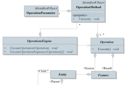
The framework has a component based architecture in order to be as adaptable and customizable as possible. Components can be added and recognized by the system even during runtime. AEGIS supports both vector geometry and remotely sensed images based on the well knownSimple Feature Accessstandard. A wide variety of source formats is supported for storage of spatial data. These sources are represented as data sets known asentitiesin the framework. Entities may refer to a single object, or may be collections consisting of multiple parts (child entities), allowing handling of partial or distributed datasets. An internal revision control sys-tem is also provided for maintaining information on alteration of data and reverting changes.
The processing module uses a meta descriptor system to support runtime man-agement and extension. New operations may be added, or existing operations can be extended to support new kind of input data. Operations may also be provided in multiple versions, when adding new features or altering functionality. The execution of the operation is performed using anoperations engine, which manages all
opera-tion metadata, and parallel execuopera-tion. The operaopera-tions engine can be implemented to any environment able to perform the execution of operations.
The schema of data and operation management can be seen in Figure 1.
Fig. 1 The processing schema of the AEGIS framework
As data management, entities and operations engines are all interchangeable, the advancement of the framework to use Hadoop as storage and execution platform, can be performed by only modifying these components. Adaptation is facilitated by the streaming capabilities of Hadoop, and the easy file system access using REST. However to benefit from the strengthen parts of the distributed environment, many extensions should be added, mainly to data management.
4 Data management
To enable spatial data processing in the cloud, well designed data management is required, as spatial features may come either in vector or raster format, and may contain descriptive information (metadata).
As seen in Section 2, to enhance the performance of spatial queries, the data can be distributed in a variety of ways. For most spatial operations, distribution based on spatial extent can drastically enhance performance of spatial operations. For efficient access, indices can be constructed at node level and system level [18]. Parts of the data can be stored as files (preferably in a simple format). From the system’s point of view, these parts can still be considered as a single feature, as they can be modeled as child entities of a single (parent) entity. The parent entity
can also be considered as a spatial index structure mapping the partitions to their original position within the data.
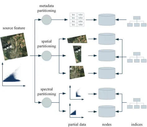
However, different operations may prefer a different approach to distribution. For example, in the case of remotely sensed imagery, a clustering operation usually works on the multispectral space of the image instead the original domain. Thus, the data should be partitioned based on the position of spectral values instead of their spatial position in the image. Another concern is that queries may also be performed based on metadata, which is not in accordance with the spatial or spectral data based distribution. To overcome this, feature metadata should be separately stored and indexed from the geometry, isolating nodes that store vector and raster content, and nodes that store metadata.
One can think of several other methods to distribute the original data based on different usage criteria. This results in thedistribution strategybecoming an argu-ment in the process, which can be defined based on the knowledge of possible fu-ture operations. Even multiple strategies can be applied to the same data, resulting in redundant storage, but more efficient execution of operations. Figure 2 displays the usage of three different partition strategies performed on the image. In the dis-tributed file system the image parts are stored based both on spatial content and spectral space content, whilst the metadata is stored separately.
In case the data is exported from the file system, anaggregation strategymay be performed to combine the parts to form a single feature.
As properties of the dataset may change over time (due to input from new datasets or removal of stored data), a maintenance service is also required that can perform redistribution of data and index updating. The redistribution may also apply new distribution strategies to the data, when new requirements are made by operations. As maintenance requires the moving of data from one node to another, the service should monitor system activities and perform tasks in the background, when the specified nodes are not in use.
When working with Hadoop, one must also consider the limitations of the
Hadoop Distributed File System (HDFS) [19]. A complex image processing op-eration, such as object-based thematic classification, requires multiple transforma-tions performed on the image creating intermediate results [20]. In contrary, HDFS is designed for writing once, reading many times, thus performing such operations on disk may result in performance bottleneck. To overcome this, memory based caching is required, which must be shared by the processes performing steps of the operation.
The final extension comes from user aspect. As most organizations have their spatial datasets already stored in a specific place and format (e.g. relational database), transferring all data to the cloud may not be a preferred, or may not be available (for example, the cloud is public, and the data is copyrighted). Although this may cause severe performance reduction, the possibility must be present to access data from its original source, outside the cloud. Under some circumstances (e.g. network band-width, replication of the database server), accessing external data may become as fast as accessing data located on HDFS.
Fig. 2 The distributed storage model performing partitioning using three strategies
In conclusion, the data management component of the framework is extended with three services.
• Thedata import/export service, performing distribution and aggregation of data using one or more strategies, building indices, and allowing access to both data located on HDFS, and data located on external sources. Each dataset becomes an entity, and each distributed part becomes a child entity to be accessed by AEGIS operations.
• The data maintenance service performing redistribution of data and updating of indices in the background. The maintenance should have no impact on the properties of the entities.
• The cache manageroperating the local in-memory cache at each node. These caches realize entities during wokflow execution.
5 Processing data
Based on the data management system described in Section 4, adapting the execu-tion model to MapReduce paradigm is a straightforward process.
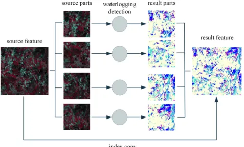
The enhancement to data management enable the distributed processing of data, as operations on a single feature can be performed by processing the partial features, which have been created using a specific distribution strategy. Before execution, the best fitting distribution of the data can be chosen based on the properties of the operation, for example, spatial partitions in case of image segmentation, spectral partitions in case of image clustering. The parts are processed in parallel, with the resulting data written to the distributed file system. As operations may produce spa-tial or spectral data in the same, or greater magnitude as the source data, moving results from one node to another is not always an option. Thus, these parts are not aggregated together physically, but can still be considered as parts of a single result. For this purpose, the initial structure of the parent entity (e.g. the spatial index) is copied to form a parent entity of the resulting dataset. An example for waterlogging detection can be seen in Figure 3.
These operations are performed as MapReduce processes by an operations en-gine working in the Hadoop environment. TheMapfunction executes the main op-eration on the partial data on a single node. In case of most opop-erations, the results are independent of another, thus no further action is required. However, in some cases the results of multiple parts need to be merged together. For example, image segments computed on individual parts may be combined. This combination may be performed using an aggregation strategy, executed in theReducefunction.
Fig. 3 Waterlogging detection performed in distributed environment
The engine can also handle the execution of workflows built up from multiple operations that are performed sequentially. For example, thematic classification can be performed by first segmenting the image, then clustering the segments, and
fi-nally classifying the clusters. If no merging of intermediate results is required, each operation can be performed in the same Map stage. In this case each intermediate result can be stored in the local cache to enhance performance.
To summarize, operations are performed using the MapReduce model in the fol-lowing manner:
• In case no merging of results is required, the operation, or multiple operations can be performed using a single Map function, and the Reduce functionality is omitted.
• In case merging of results is required, the operation is performed using the Map function, and an aggregation is performed in the Reduce function. When mul-tiple operations in a workflow require merging of intermediate results, mulmul-tiple MapReduce processes are used for performing processing.
The execution process is managed by the operations engine and the Hadoop envi-ronment. All operations are automatically loaded on the dedicated node (containing the partial data), and executed in MapReduce form. The executed operations are not specialized for Hadoop in any way, as the environment handles all specialization responsibilities.
6 Conclusion
The paradigm shift to cloud computing can be a tough challenge, and usually re-quires a great deal of effort, because data management has to be reconsidered, algo-rithms have to be redesigned. However, when working with a flexible framework, the modification may be completely performed on system side, without the need of reimplementing algorithms. The porting of the AEGIS framework to Hadoop re-quires some effort, but does not require complete overhaul. Much thought has been given on achieving the most performance in the given circumstances.
After the implementation is finished, evaluation will follow by examining the system from the performance aspect. Based on the exact results, the system will be further tuned to achieve the most valuable speedup.
Acknowledgements This research is founded by the FP7 project IQmulus (FP7-ICT-2011-318787) a high volume fusion and analysis platform for geospatial point clouds, coverages and volumetric data set.
References
1. Agrawal D., Das S., El Abbadi A.: Big Data and Cloud Computing: Current State and Future Opportunities. InProceedings of the 14th International Conference on Extending Database
2. Dean J., Ghemawat S.: MapReduce: Simplified Data Processing on Large Clusters.Commun. ACM, 51 (1), 107–113 (2008).
3. Bhandarkar M.: MapReduce programming with Apache Hadoop. InParallel Distributed
Pro-cessing (IPDPS), 2010 IEEE International Symposium on, 1–1 (2010).
4. Che D., Safran M., Peng Z.: From Big Data to Big Data Mining: Challenges, Issues, and Opportunities. InDatabase Systems for Advanced Applications, vol. 7827 ofLecture Notes
in Computer Science, 1–15 (2013).
5. Franklin M.: The Berkeley Data Analytics Stack: Present and future. InBig Data, 2013 IEEE
International Conference on, 2–3 (2013).
6. Csornai G., Mikus G., N´ador G., Hubik I., L´aszl´o I., Suba Z.: The first seven years of the remote sensing based Ragweed Monitoring and Control System. InEARSeL eProceesings, 110–118 (2011).
7. Giachetta R.: AEGIS - A state-of-the-art spatio-temporal framework for education and re-search.OSGeo Journal, 13, 68–77 (2014).
8. Yang C., Goodchild M., Huang Q., Nebert D., Raskin R., Xu Y., Bambacus M., Fay D.: Spa-tial cloud computing: how can the geospaSpa-tial sciences use and help shape cloud computing?
International Journal of Digital Earth, 4 (4), 305–329 (2011).
9. Cary A., Sun Z., Hristidis V., Rishe N.: Experiences on Processing Spatial Data with MapRe-duce.Scientific and Statistical Database Management, vol. 5566 ofLecture Notes in
Com-puter Science, 302–319 (2009).
10. Eldawy A., Mokbel M. F.: A Demonstration of SpatialHadoop: An Efficient Mapreduce Framework for Spatial Data.Proc. VLDB Endow., 6 (12), 1230–1233 (2013).
11. Aji A., Wang F., Vo H., Lee R., Liu Q., Zhang X., Saltz J.: Hadoop GIS: A High Performance Spatial Data Warehousing System over Mapreduce.Proc. VLDB Endow., 6 (11), 1009–1020 (2013).
12. Thusoo A., Sarma J. S., Jain N., Shao Z., Chakka P., Anthony S., Liu H., Wyckoff P., Murthy R.: Hive: A Warehousing Solution over a Map-reduce Framework.Proc. VLDB Endow., 2 (2), 1626–1629 (2009).
13. Golpayegani N., Halem M.: Cloud Computing for Satellite Data Processing on High End Compute Clusters. InCloud Computing, 2009. CLOUD ’09. IEEE International Conference on, 88–92 (2009).
14. Alonso-Calvo R., Crespo J., Garc’ia-Remesal M., Anguita A., Maojo V.: On distributing load in cloud computing: A real application for very-large image datasets.Procedia Computer
Science, 1 (1), 2669 – 2677, (2010).
15. Zhang C., Sterck H., Aboulnaga A., Djambazian H., Sladek R.: Case Study of Scientific Data Processing on a Cloud Using Hadoop. InHigh Performance Computing Systems and
Applications, 400–415 (2010).
16. Zaharia M., Chowdhury M., Franklin M. J., Shenker S., Stoica I.: Spark: cluster computing with working sets. InProceedings of the 2nd USENIX conference on Hot topics in cloud
computing, 10–16 (2010).
17. Engle C., Lupher A., Xin R., Zaharia M., Franklin M. J., Shenker S., Stoica I.: Shark: Fast Data Analysis Using Coarse-grained Distributed Memory. InProceedings of the 2012 ACM
SIGMOD International Conference on Management of Data (SIGMOD ’12), 689–692 (2012).
18. Liao H., Han J., Fang J.: Multi-dimensional Index on Hadoop Distributed File System. In
Networking, Architecture and Storage, 2013 IEEE Eighth International Conference on, 240–
249 (2010).
19. Shvachko K., Kuang H., Radia S., Chansler R.: The Hadoop Distributed File System. InMass
Storage Systems and Technologies (MSST), 2010 IEEE 26th Symposium on, 1–10 (2010).
20. Dezs˝o B., Fekete I., Gera D., Giachetta R., L´aszl´o I.: Object-based image analysis in remote sensing applications using various segmentation techniques.Ann. Univ. Sci. Budap. Rolando