PLANNING MALAYSIA Conservation With Development: Focus On Langkawi
Planners should be aware that a place has truth not just based on the facts of its existence, but also on the things believed to be true about it (Wortham-Galvin, designobserver.com/ media/pdf/mythologies_of_497.pdf). As they seek to shape the built environment of a place, they must seek to legitimise their actions by infusing them with local qualities that can attract those who seek authentic, place-based experiences. Myths and legends can become a powerful design and planning tool if deployed judiciously. This is because myths and legends are always embedded within a place. Changing names or reducing a neighbourhood to rubble in order to make way for a more profitable project can mean having committed a sacrilege even if the planner is unaware of the implication. This is because the erasure of places or change of place names would mean established patterns of human relationship could be destroyed. Therefore, planners should directly engage those who reside in the vicinity before making changes, or build upon the existing cultural heritage (myths, legends, relationships etc) in shaping or remaking a space. Within this context, Langkawi is at present undergoing rapid change and development, after its seven-generation long hiatus as a result of the “Mahsuri’s curse”. In line with the objective to develop and transform new places are planned and created and given new names, while some existing ones are redeveloped or recreated and renamed. In the process the myths and legends that underlie the place names could be placed under threat or even be lost if planners are not sensitive to this invaluable cultural heritage. Should that happen the taglines such as “99 magical islands” or “isles of legends” that have been accorded to Langkawi islands could become meaningless.
LANGKAWI ISLAND: LEGENDS AND ORIGIN OF PLACE NAMES
Langkawi – an archipelago of 99 islands – located just off the shores of the Northern Kedah State in Peninsular Malaysia is famous for its beaches and its tranquillity besides having been conferred the global geopark status by Global Geopark Network (GGN) and endorsed by UNESCO besides having been declared a duty-free island by the Central Government of Malaysia. Of the 99 islands only three are inhabited – Langkawi islands, Tuba islands and Dayang Bunting island (island of Pregnant Maiden). Most of the islands’ population is found on the largest and main island – Langkawi Island that measures 478.5 sq km. The Langkawi archipelago has a total population of approximately 103,075 (Langkawi Development Authority 2010).
The island possesses long geological history that dates back to the early Cambrian period (Mohd. Shafeea Leman et al. 2007), with unique geodiversity and geological landscapes, which form many geoheritage sites. Among the main attractions of Langkawi Geopark are its oldest rock formation of high geological value, pristine beaches and education based tourism. Within the Langkawi Geopark are located three geoforest parks: the Machincang Cambrian Geoforest Park, Kilim Karst Geoforest Park and Dayang Bunting (trans. Pregnant Maiden) Marble Geoforest Park.
Picture 1 & 2 : Gunung Raya - highest mountain on Langkawi islands formed of granite rock
Source: Courtsey of Tanot Unjah 2011
Forming the backbone of the island are two prominent mountains called Gunung Raya
PLANNING MALAYSIA Conservation With Development: Focus On Langkawi Picture 3 : Locations of Mount Machincang, Mount Raya and Sawar Hill
Source: Courtsey of Tanot Unjah 2011
Langkawi is a bound with myths and legends. However, many of these tales exist in the form of oral traditions, although efforts have been made to document them (eg. Mohamed Zahir Haji Ismail. 2000). Many of the early attempts on documenting the myths are mainly in the form of anecdotes or brief descriptions of particular myths and legends, which focus on the magical or supernatural aspects (Norhanim Abdul Razak 2010). While some of the legends have some basis in truth and historical events, others have made the natural landscape come alive with fantastic beings. It is believed that centuries ago skilled storytellers spun wondrous tales of folklores, history, myths and legends regarding celestial beings, demons, giants, warriors, heroes and beautiful maidens. These stories were then handed down from generation to generation mainly through oral tradition. These myths, legends etc are still strongly woven into the lives of the local people who are quite convinced of their authenticity. Also there could be more than one version of the narration to explain the possible origin of a place name.
TRACKING THE LEGEND OF GUNUNG MACHINCANG AND GUNUNG RAYA
As mentioned earlier Langkawi is rich with myths and legends. The fact that many are not scientifically or historically proven only enhances the mystery that surrounds the island. Of the many myths and legends, the fight between two giant warriors Mat Chincang and Mat Raya is the most dramatic. It is said that the damage caused by the fight gave rise to the names of many places in Langkawi including Gunung Machincang, Gunung Raya, Kuah, Ayer Hangat, Tanjung Chincin, and Belanga Pecah. However, this article only highlights the place names that are believed to have their origin in Gunung Machincang and Gunung Raya.
As the legend goes, centuries ago there lived two feuding giants called Mat Chincang and Mat Raya. A third giant, Mat Sawar (sawar is colloquial for sabar or patient), attempted to reconcile them. As fate would have it, Mat Raya’s son and Mat Chincang’s daughter fell in love with each other and wanted to marry. Although Mat Chincang was not in favour of the plan, he nevertheless consented. Mat Raya, on the other hand, welcomed the union as he thought that it would help heal the animosity that had long existed between the two families. However, during the marriage ceremony an argument broke out between the two giants, which then led to a fight. The ferocity of the fight resulted in the pots and pans and other utensils used to prepare the wedding feast being flung to
The fracas and pandemonium disturbed the sleep of Sang Gedembai of Gua Cerita (Cave of Legends), a wicked giantess witch who would cast deadly spells on anyone who dis-pleased her. Furious on being disturbed from her sleep she cursed the brawling giants and transformed them into the island’s major stone mountains. Mat Chincang turned into Mount Machincang and Mat Raya became Mount Raya. It is believed to this day that they still remain locked in stone watching over the island (Picture 4). Mat Sawar who had tried to mediate between them and break up the fight was unfortunately caught in the process and was transformed into the hill called Bukit (hill) Sawar that now separates the two mountains.
PLANNING MALAYSIA Conservation With Development: Focus On Langkawi
various parts of the island. Where the pots and pans and their contents landed emerged villages, towns and island with names to commemorate the events.
The jagged bare look of Mount Machincang gave rise to the story that Mat Chincang was slashed and chopped to death by Mat Raya. By contrast, Mount Raya has a smooth formation that has been used to support the story that Mat Raya had welcomed the marriage between his daughter and Mat Chincang’s son. Also, he did not start the ill-fated fight.
LEGENDS AND THE ORIGIN OF PLACE NAMES
As mentioned earlier, so intense was the fight between the two giants that pots and pans flew and the earth shook. On being kicked a big pot containing gravy broke and its contents spilt to the ground. The spot where the contents spilt grew into a place known as Kuah (gravy) and where the broken pot landed emerged the village called Belanga Pecah (broken pot).
Kuah, situated on the south-western tip of the main island, is the largest town and port, where ferries from the mainland and the island of Penang anchor (Picture 5). Meanwhile during the tremor that resulted from the fight, a cauldron tipped over, spilling the hot water inside it. The spot where the water spilt has since been known as Ayer Hangat (hot water) where hot springs can be enjoyed.
As has been illustrated for the population of Langkawi Island, particularly the local residents, the towns described have stories, or narratives that bring these places to life. They are narratives of places that are shared among people about specific geographical locations (Bird 2002:521) and which had given them and the place their social identities.
MAP 1 : Place Names that are Believed to Have its Origin in the Legend of Mount Machincang and Mount Raya
Source: Mohd Shafeea Leman et al. 2007: 47
PLACE NAMES: LEGENDS AND GEOLOGICAL EXPLANATIONS
PLANNING MALAYSIA Conservation With Development: Focus On Langkawi
MAP 2 : Map Showing the Geological Formation of Langkawi Island
Source: Courtesy of Tanot Unjah 2011
If we are to base on scientific explanation of place names, observation of the geological landscape of Langkawi shows that some of the landscapes that are related to the legends can be classified based on the various types of rocks to be found on the island, particularly where the places are located. The rocks have different structures, the result of the different weathering processes involving the various natural elements. For example Mount Machincang probably got its name from its jagged peak – naturally eroded fractured sandstone layers that have often been related to the legend of Mat Chincang and the possible origin of the name Machincang (Mohd Shafeea Leman et al. 2007:50). Mount Raya, on the other hand, is of granite rock from the igneous stock represented by broad conical hill with gently concave flanks (Mohd Shafeea Leman et al. 2007:60).
The movement of the Kisap Thrust Fault can be related to the existence of the hot salt-water springs at Ayer Hangat (hot salt-water). Based on the geological explanation, Tanjung Chincin forms part of the anticline fold in the Machincang rock formation (Tanot Unjah 2011). A ring-shaped formation found in this area is the result of a fault on the sandstone layer due to sea erosion. The ring is said to be visible only during low tide (Picture 6).
CONCLUSION
A place and placemaking do not exist in a cultural vacuum. It is always undertaken in relations to the realm of cultural practices and human experience. The practices of placemaking and the experiences of a place must be understood as socio-culturally and politically organised. It is a dialectical engagement of socially, historically, and culturally constituted schemas of practical activity with worldly circumstances. In that regard place names are an important part of the geographical and cultural environment and care must be taken to protect the place name heritage. This is because place names identify geographical entities and represent irreplaceable cultural values of vital significance to the people’s sense of wellbeing and sense of place. In a rapidly changing and developing society planners and the society in general must ensure that in place naming process by planners and administrators, cultural heritage is protected and taken into serious consideration. In fact planners should harness and capitalise on the existing myths and legends of Langkawi islands to enhance and sustain the sense of place, the sense of belonging and even the sense of history of the local population.
The history of Langkawi is intricately entwined with the many tales, myths and legends, many of which have been handed down by word of mouth from generation to generation. The legend that is associated with Mount Machincang, Mount Raya and other related places demonstrates the imaginaries and visualisation regarding mountains that have been handed down through generations. Each tale relates to the shapes of the respective landforms thus giving reality to the stories told. Such imaginaries of place names and their association with the natural landscapes contribute to the richness of the local cultural traditions. Although the narrations are regarded as mere myths, legends or folklores, the references still suffuse life to this day in the island of Langkawi despite the scientific explanations given. These stories besides making fascinating reading also tell us a great deal about how people in the past saw and understood the world around them. These stories also give an insight into the richness of traditional cultures in associating themselves with nature and environment.
ACKNOWLEDGEMENTS
PLANNING MALAYSIA Conservation With Development: Focus On Langkawi
of Institute of Environment and Development, Universiti Kebangsaan Malaysia, for graciously allowing us to use Pictures 1, 2, & 3 and Map 2.
REFERENCES
Agnew, J.A. and Duncan, J.S. 1989. Introduction. In Power of Place: Bringing Together Geographical and Sociological Imaginations. Agnew, J.A. and Duncan, J.S., eds. Boston: Unwin Hyman.
Anderson, B. 1991. Imagined Communities. (Revised edition). Philippines: Anvil Publishing.
Bender, B. & Winer, M. eds. 2001. Contested Landscapes: Movements, Exile and Place. Oxford: Berg.
Bird, S.E. 2002. It Makes Sense to Us: Cultural Identity in Local Legends of Place.
Journal of Contemporary Ethnology, 31, 519-547.
Castoriadis, C. 1987. The Imaginary Institution of Society (trans. Kathleen Blamey). Cambridge: MIT Press.
Dundes, A. 1984. Introduction. In Sacred Narrative: Readings in the Theory of Myth.
Dundes, A., ed. Berkeley: University of California Press.
Frake, C. 1996. Pleasant Places, Past Times and Sheltered Identity in Rural East Anglia. In Senses of Place. Feld, S. and Basso, K.H., eds. Santa Fe, NM: School of American Research Press.
Harrington, J.T. 2004. ‘Being Here’: Heritage, Belonging and Place Making. A Study of Community and Identity Formation at Avebury (England), Magnetic Island (Australia) and Ayutthaya (Thailand). Thesis submitted for the degree of Doctor of Philosophy in the School of Anthropology, Archaeology and Sociology, James Cook University. Unpublished.
Harvey, D. 1993. From Space to Place and Back Again: Reflections on the Conditions of Postmodernity. In Mapping the Futures: Local Cultures, Global Change. John Bird, et al., eds. London & New York: Routledge.
Langlois, J.L. 2008. Legend. In The Greenwood Encyclopaedia of Folktales and Fairy Tales. Haase, D., ed. Westport: Greenwood Press. Pgs. 569-571.
Lanham, K.F. 2007. Planning as Placemaking: Tensions of Scale, Culture and Identity. Paper submitted to Virginia Polytechnic Institute and State University School of Public and International Affairs college of Architecture and Urban Studies.
Leach, E.1984. Conclusion: Further Thoughts on the Realm of Folly. In Text, Play and Story: The Construction and Reconstruction of Self and Society. Bruner, E.M., ed. Washington D.C.: American Ethnological Society.
Mohd Shafeea Leman, Kamarulzaman Abdul Ghani, Ibrahim Komoo and Norhayati Ahmad. eds. 2007. Langkawi Geopark. Bangi: LESTARI, UKM & LADA Publications.
Myers, F.R. 2000. Ways of Placemaking. In Culture, Landscapes and the Environment.
The Linacre Lectures 1997. Flint, K. & Morphy, H., eds. Oxford: Oxford University Press.
Norhanim Abdul Razak 2010. From Fairy Princess to a Wronged Maiden: Assessing Self-representation of Langkawi as the ‘Isle of Legends’. In Proceedings of Regional Conference on Tourism Research: The State of the Art and its Sustainability. Badaruddin Mohamed, ed. Universiti Sains Malaysia, Penang, Malaysia. 13-14 December. 338-348
Rubertone, P.A. ed. 2008. Archaeologies of Placemaking: Monuments, Memories and Engagement in Native North America. Walnut Creek, Cal: Left Coast Press.
Silko, L.M. 1994. Landscape, History and the Pueblo Imagination. In Family of Earth and Sky: Indigenous Tales of Nature from Around the World. Elder, J. & Wang, H.D., eds. Boston: Beacon.
Tangherlini, T.R. 1990. It Happened Not Too Far from Here: A Survey of Legend Theory and Characterization. Western Folklore, 49(4), 371-390.
Tanot Unjah, Sharina Abdul Halim and Che Aziz Ali. 2011. Warisan Geologi: Perkaitan Landskap dan Lagenda di Langkawi Geopark. (Trans. Geological Heritage: Relationship between Landscape and Legends in Langkawi Geopark). Paper presented at the National Symposium on Heritage and Conservation. 29 April – 1 May. Kuching, Sarawak.
Taylor, C. 2002. Modern Social Imaginaries. Public Culture 14, 91-124.
Tilley, C. 1994. A Phenomenology of Landscapes: Paths, Places and Monuments.
Oxford: Berg.
Tuan, Y.F. 1977. Space and Place: The Perspectives of Experience. Minneapolis, MN: University of Minnesota Press.
Willis, R. 1993. Introduction. In World Mythology. Willis, R., ed. New York: Henry Holt. Wortham-Galvin, B.D. Mythologies of Placemaking. designobserver.com/media/pdf/
PLANNING MALAYSIA Conservation With Development: Focus On Langkawi
INTRODUCING NETWORKS IN PLANNING:
AN EXAMPLE FROM LANGKAWI
Chan K. L. Geraldine1
Faculty of Social Sciences and Humanities
UNIVERSITI KEBANGSAAN MALAYSIA
Halimaton Saadiah Hashim2 and Sarah Aziz3
Institute for Environment and Development (LESTARI)
UNIVERSITI KEBANGSAAN MALAYSIA
Abstract
This article introduces networks as a potential technique in participatory planning and implementation activities, including community activities, social events, projects, and conference events. This recommendation is backed by findings of some networks-like characteristics indicated in past and present work relationships between relevant government and private stakeholders in a study of a few Langkawi Geopark activities. The findings were obtained from an analysis of some geopark activities and interview data given by various public and private stakeholders. The relationships had led to the successful completion of various geopark activities. This article argues that the relationships have the potential to be developed into effective networks of relationships in future geopark activities. Therefore, relevant authorities, policy makers, managers, administrators and planners could consider developing existing stakeholder relationships into actual networks in their future consultation programmes with all stakeholders. This could be achieved by using networks as a technique in planning and development.
Keywords: Langkawi Geopark, networks, networks technique, networks characteristics, planning
___________________________________
1Senior Lecturer, School of Social, Development and Environmental Studies, Faculty of Social Sciences and Humanities, Universiti Kebangsaan Malaysia, 43600 Bangi, Selangor, Malaysia. e-mail: [email protected], [email protected]
2Guest Editor, Principal Fellow, Institute for Environment and Development (LESTARI), Universiti Kebangsaan Malaysia, 43600 Bangi, Selangor, Malaysia. e-mail: [email protected]. drhalimaton@ gmail.com
3Fellow, Institute for Environment and Development (LESTARI), UKM, [email protected] PLANNING MALAYSIA
Conservation With Development: Focus On Langkawi
INTRODUCTION
Langkawi is an archipelago of 99 islands. It is situated in the northern part of Peninsular Malaysia in the state of Kedah. Most local economic, social, cultural and political activities take place on the main island i.e. Langkawi Island. Langkawi has the oldest rock formations in Malaysia with the age of the rocks and other geological resources being about 500 million years old dating back to the Early Cambrian period (Mohd Shafeea Leman et al. 2007). Langkawi is also rich in cultural, historical and ecological heritage. The whole archipelago was declared a geopark by the Global Geopark Networks (GGN) initiatives under UNESCO in June 2007. By end of September 2011 there is a total of 87 global geoparks in 27 countries that are currently members of the Global Geopark Network (GGN) with about 32 geoparks in Asia Pacific. Langkawi is the only geopark in Malaysia and it is the first geopark in Southeast Asia.
PLANNING MALAYSIA Conservation With Development: Focus On Langkawi
Various viewpoints given by the interviewees and stakeholders cover the following issues: 1) geopark management; 2) the role and nature of LADA; 3) the role and nature of other stakeholders’ participation in geopark activities; 4) geopark development action plans of participants and other stakeholders; 5) problems and challenges faced by other stakeholders and the public in terms of participation in the activities and geopark management; and 6) suggestions for improvement of stakeholder participation in geopark development.
The study on geopark activities focused on stakeholder work relationships and cooperation in carrying out the activities. Data was obtained from face-to-face meetings with some key officers from LADA which was the main organiser. For practical reasons, this article only quotes two examples to support its arguments. The first example is the Langkawi Geopark Carnival (Karnival Langkawi Geopark in Malay language) that was recently held in Langkawi on 31 May-4 June 2011 and ended successfully. The second event is the 4th International Conference on Global Geoparks by the main organiser LADA and held in Langkawi in April 2010. Both activities generally revealed the presence of a series of work relationships between LADA and several local level agencies, Kedah state authorities, non-governmental organisations (NGOs), some village community organisations, hoteliers, schools and the local people of Langkawi. Some evidences of good cooperation between these stakeholders were revealed. Data from interviews and workshop consultations also confirmed the presence of work relationships between LADA and some stakeholders. The data confirmed that these stakeholders are always involved and cooperating in various similar activities organised by LADA. Because of that, they always meet, interact and are closely connected and interlinked. They also share some viewpoints, ideas, principles, sentiments, understanding and awareness concerning Langkawi Geopark, and their roles, functions and involvement in geopark development.
it is probably a novel effort in the geopark context. Not many academic studies have been conducted about networks in relation to planning, sustainable development, heritage conservation and generally geopark contexts. Therefore this article is an early attempt to propose networks as a technique for effective planning, particularly of future geopark activities in Langkawi or of participatory planning and implementation in general.
PLANNING FOR NETWORKS, NETWORKS FOR PLANNING
Networks are about connectedness. They are ties or relationships, or social ties if they are between people. But, why networks as a technique in planning? Why must planners, administrators, managers, policy makers, relevant authorities, researchers, or simply anybody pay attention to networks? What is so important about networks? In Christakis and Fowler’s words (2009: xi), “… The key to understanding people is understanding the ties between them ...” and, “… To know who we are, we must understand how we are connected …” (2009: xiii). They opined that “… connections affect every aspect of our daily lives …” (Christakis and Fowler 2009: 7). Social networks are all around us, “... exerting both subtle and dramatic influence over our choices, actions, thoughts, feelings, even our desires …” and our “… connections do not end with the people we know …” because beyond “…our own social horizons, friends of friends or friends can start chains of reactions that eventually reach us ...” (Christakis and Fowler 2009: 7). For Field, (2003: 1) “… relationships matter …”. For Christakis and Fowler (2009: xiii), “... our connections to other people matter most, and that by linking the study of individuals to the study of groups, the science of social networks can explain a lot about human experiences …”.
PLANNING MALAYSIA Conservation With Development: Focus On Langkawi
Two fundamental aspects of networks exist – ‘connection’ and ‘contagion’ (Christakis and Fowler 2009: 16). Connection is just ties between entities, e.g. people. Contagion pertains to what flows through the connections and the reasons for the flows to occur. To understand why and how networks (i.e. social) exist, why people connect and why networks is important in planning and implementation, we must first understand certain fundamental rules regarding the connections and contagion, i.e. the structure and function
of networks. Structure is about how connections are assembled and configured. Function is about the connections, i.e. about what the connections are for, how do the connections spread, why people make connections, what they ‘use’ to make connections, and what benefit they can get from the connections.
Since the beginning of the twentieth century, many researchers, anthropologists, sociologists, political scientists, mathematicians, economists, managers, administrators, medical practitioners, psychologists, criminologists and others use networks to understand and explain various aspects of social and daily lives. The aspects include social interactions; social group unity; ethnic conflict; organisational behaviour and growth; work productivity, behaviour and motivation; managerial performance; spread of diseases; love and romance; deviance and criminal behaviour; friendship development; education issues; job seeking and recruitment; corporate elite power; work citation; community development; community participation; emotional contagion or spread of emotions; communication process; inter-organisational relations; immigration patterns; work cooperation; marriage and family lives; personality development; business-politics relations and gangsterism.
of business-politics relations primarily evident at the top corporate sector in Malaysia. For Chan, social networks are a potential form of social capital. Nicholas Christakis, a medical doctor, and James Fowler, a political scientist, collaborated to apply the networks method to study the spread of happiness, disease epidemic, weight gain, friendship ties, loneliness, the finding of partners and others through social networks (Christakis and Fowler 2009). They found that people’s connections affect the way they think and do but at the same time, they shape their networks to determine how to and what they think and what to do. Granovetter’s (1973) interesting networks study among a group of technical, managerial and professional workers in a Boston suburb on job recommendation based on personal contact discovered that people with relatively weak networks established with distant friends and strangers got recruited at a relatively faster rate than people with relatively strong ties formed with close friends. His famous ‘strength of weak ties’ theory still stands strong even today. Burt (2010) found that an actor’ position in an organisational networks has an impact on its power, influence and reputation, and peer evaluation, be they a manager, chief executive officer, banker or analyst. Positions may be in terms of bridging between different networks or staying put in a single network.
Promoting planning for networks and networks for planning shall begin by firstly elaborating the structure and functions of networks. Elaboration on the application of networks technique into geopark activity planning follows. In this article, planning refers to general planning in various fields such as infrastructure and utility planning, neighbourhood planning, land use planning, community planning, tourism planning, public participation process in planning, project planning and others.
UNDERSTANDING NETWORKS
Anyone who wishes to engage networks as a technique in planning should be aware of the following aspects of networks: key networks elements, networks formation and maintenance (networks stability), networks structural qualities, and networks merits. They explain the structure and functions of networks.
Key Networks Elements
PLANNING MALAYSIA Conservation With Development: Focus On Langkawi
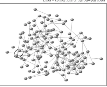
In networks terms the people who are interlinked are called ‘nodes’. Nodes could be firms, organisations, computers, events and others (Barney 2004, Scott 1991). The ties are ‘relationships’ or connections established between the nodes; called ‘social relationships’ if they are between people or organisational networks if they are between organisations (Barney 2004, Scott 1991). Figure 1 reveals a hypothetical visual representation of networks graph (networks of connections between nodes e.g. persons) (Christakis and Fowler 2009 http://www.connectedthebook.com/pages/slides.html 21 October 2011). Various patterns and types of relationships are visible in networks. For Wasserman and Faust (1994: 6), patterns of interactions revealing regularities lead to the emergence of a ‘structure’ of networks. ‘Ties’ also reveal the roles that nodes play in the networks. ‘Nodes’ and ‘ties’ are two of three key networks elements. Networks formation, maintenance and stability may be ensured through frequency of interactions and meetings, and regularity of actors’ participation. This means that the same actors meet one another in various different meetings or events.
Figure 1: A Hypothetical Example of a Network Graph based on Connections between Network Actors (Nodes)
NOTE: The network graph shows that most nodes are connected. However, some nodes are connected to several or many nodes establishing series of connections. Some nodes are isolates (not connected to any node). The graph demonstrates various pairs of nodes creating dyads and various dyads creating the connections.
Source: Christakis & Fowler 2009 http://www.connectedthebook.com/pages/slides.html 21 October 2011
Node = a network actor (e.g. person)
Lines = connections or ties between nodes
The third networks element is ‘flows’ which show what pass between and through the nodes along ties (Barney 2004: 26). This is the contagion aspect of the network, which demonstrates the function of networks. Flows can be in the form of gossip, data, money, camaraderie, support, emotions like love or hate, aid and others (Barney 2004: 26); all tangible and intangible in nature. ‘Flows’ indicate the reasons behind networking or function of networks, e.g. why people establish networks. Therefore, to understand our own human and social action and behaviour, we must understand the connections and their characteristics, i.e. the ‘flows’ and their functions that define the connections. For instance, ‘flows’ may inform that people interact and establish networks because they want to get something from each other or exchange something with one another. Moreover, similar ‘flows’ may facilitate the networking, for instance, similarities in terms of knowledge; need for mutual support and respect; emotions; interests; backgrounds; economic status; viewpoints; mindsets; principles, beliefs and values; and others. As mentioned earlier, we tend to connect with people who have something in common with us. Similar ‘flows’ may then encourage actors to use their connections to achieve or obtain something together that may otherwise be difficult to achieve if they are on their own. If they do not establish networks, ‘flows’ that are similar may just stabilise, support or sustain the networks.
PLANNING MALAYSIA Conservation With Development: Focus On Langkawi NETWORKS STRUCTURAL QUALITIES
The following paragraphs further elaborate the structure and functions of networks. The nodes, ties and flows have distinctive structural qualities. For Barney (2004: 26-27), the qualities are “… centralized, decentralized (i.e., multicentred), or distributed (i.e. centreless); hierarchical or horizontal; bounded or boundless; finite (i.e., with fixed limits on the number of nodes and ties) or proliferating (i.e., with no limit on the number of nodes and ties); accessible or inaccessible; inclusive or exclusive; intensive (i.e., few nodes linked by a multiplicity of dense, strong ties) or expansive (i.e., many nodes linked by relatively sparse, weak ties); interactive (i.e., enabling reciprocal, multidirectional flows) or non-interactive (i.e., enabling only one-way, uni-directional flows) … ”. Beside ‘nodes’, ‘ties’ and ‘flows’, sub-networks can exist within a network and many networks can be connected to many other networks. Moreover, some networks may overlap with one another. The meanings of these qualities are generally about networks actor centrality (seen through network positions and roles), networks density and centralisation, networks cohesion, networks groupings and sub groupings (cliques) and others. They indicate nature of social roles, liaison, prestige, social cohesion, reciprocity, mutuality, exchange, influence, dominance and conformity. Network structural qualities and their meanings explain a lot about network functions and benefits.
NETWORKS FUNCTIONS AND BENEFITS
Apart from knowing the three main networks elements and their structural qualities, anyone who utilises networks as a technique also ought to be aware of the functions of those structural qualities. Generally, the awareness of networks significance in social living is highlighted by the fact that we, human beings, tend to organise many forms of social living, daily and working lives around relationships specifically in the form of networks, and are able to get things done through those networks. In other words, in order to live and survive in the social world, we create, shape, affect and influence networks, but at the same time, networks also affect, influence, shape and even control us as we are always surrounded, affected and influenced by other humans, including the ones we build networks with.
is greater than the sum of its parts. People connected into groups (networks) are just able to do things that a disconnected collection of individuals sometimes cannot. Therefore, to understand our own human and social behaviour and action, we must understand the characteristics of our connections or networks. The explanation of various network functions and merits directly relates to this basic networks theory.
Depending on the kind of structural qualities and the related meanings and levels of networking, networks in one way or another function to help people get involved in the networks to better achieve individual/personal, organisational, social (e.g. groupings, communal), economic, business and political goals. Networks (social context) may enable and/or constrain human and social actions and outcomes. Wasserman and Faust argue that the difference between a social network’s explanation of a process or phenomenon and a non-network’s explanation is the “… inclusion of concepts and information on relationships among units …” (e.g. people) in a study (Wasserman and Faust 1994: 6). For them, the task of networks researchers is to identify “… properties of the social (economic or political) structural environment, and how these structural properties influence observed characteristics and associations among characteristics …” (1994: 8).
PLANNING MALAYSIA Conservation With Development: Focus On Langkawi NETWORKS IN PLANNING, PLANNING FOR NETWORKS IN LANGKAWI GEOPARK
Planners undertaking participatory planning of Langkawi Geopark development activities can incorporate networks technique into their mandatory and non-mandatory consultations: interpersonal dialogues, workshops and others with stakeholders. The planners’ personal contacts with consultation participants can stimulate networks formation and maintenance through firstly influencing all participants on the benefits of sustainable development and heritage conservation. At the same time, they can influence those people about the need to work together in every single geopark development regardless of socio-economic backgrounds. The resulting networks possibly established between them and the participants as well as between the participants themselves will be used to effectively develop and implement geopark plans.
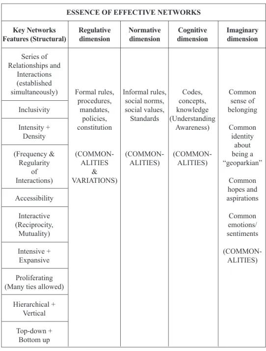
Table 1 : Essence of Networks for Effective Langkawi Geopark Development
Source: Adapted from Sorensen & Torfing 2007 and Barney 2004. ESSENCE OF EFFECTIVE NETWORKS
Key Networks Regulative Normative Cognitive Imaginary Features (Structural) dimension dimension dimension dimension
Series of Relationships and
Interactions (established
simultaneously) Formal rules, Informal rules, Codes, Common
procedures, social norms, concepts, sense of
Inclusivity mandates, social values, knowledge belonging
policies, Standards (Understanding
Intensity + constitution Awareness) Common
Density identity
about
(Frequency & (COMMON- (COMMON- (COMMON- being a
Regularity ALITIES ALITIES) ALITIES) “geoparkian”
of &
Interactions) VARIATIONS) Common
hopes and
Accessibility aspirations
Interactive Common
(Reciprocity, emotions/
Mutuality) sentiments
Intensive + (COMMON-
Expansive ALITIES)
Proliferating (Many ties allowed)
Hierarchical + Vertical
PLANNING MALAYSIA Conservation With Development: Focus On Langkawi
In reference to Table 1, the ‘regulative’ dimension includes rules, mandates, procedures and policies stipulated within the Federal and Kedah state constitutions. Rules, procedures, mandates and policies of LADA and those of other organisational stakeholders are also included (Sarah Aziz 2010). They may be varied but they can still be integrated and synchronised for effective geopark development. The ‘normative’ dimension comprises norms, values and standards that are formal, cultural and social in nature. The institutionalised framework also has a ‘cognitive’ aspect because it produces codes, concepts and specialised knowledge, for instance about activities and projects. Finally, negotiations for any geopark planning even have an ‘imaginary’ aspect whereby identities, ideologies and common hopes about the geopark may be generated (Sorensen and Torfing 2007). The imaginary level has emotive and sentiment components. The imaginary, cognitive and normative dimensions, namely the informal ones, also regulate networks behaviour in addition to rules, regulations and procedures. Moreover, some of the regulative, normative, cognitive and imaginary aspects can be conceptualised in this article as network ‘flows’. Similar or common aspects (‘flows’) found in the regulative, normative, cognitive and imaginary dimensions facilitate the networks.
SERIES OF RELATIONSHIPS AND INTERACTIONS, EXCLUSIVITY AND PROLIFERATING
involvement is due to formal organisational duties and responsibilities or public sector work obligations, corporate goals, socio-cultural norms and values of particular social collectivities, cultural or religious traditions or voluntary intentions.
To quote an example of stakeholder involvement based on formal duties and goals in a recent geopark activity, ‘Langkawi Geopark Carnival 2011’, stakeholders were LADA (main organiser), local agencies, NGOs, schools, colleges, hoteliers and businesses. Some of the government sectors were LADA, Majpeba, Pejda, Japam, Podiram, Kema, Marim, Beliasu, and Tubacom. Some NGOs were Latga, Lata, Kumperika, Fotoclu, Pasamal, Motoclas, Atiskeb, Wayaku, and Mahot, while Srigenda and Koleko were the education organisations. Hotbellvist and Azdaent were hotelier and business sectors involved in the activity, respectively. A local mosque was also involved. Except for LADA, the names of these organisations are not actual names. Their actual names are concealed for ethical reasons. These stakeholders were all involved in the activity in terms of decision-making and/or planning and/or implementation. The level of cooperation given by these stakeholders to LADA was generally good. In another example of activity during the 4th International UNESCO Conference on Geoparks (Geopark Conference in short) held in April 2010 and mainly organised by LADA, some of the government stakeholders who participated were Majpeba, Pejda, Minedip, Forsdip, Watdip, Landip, Edudip, Podiram, and Ukem. Some of the NGOs were Latga, Lata, Mahot, Natusoc and Mat. Several schools in Langkawi also participated.
A plurality of public and private actors was indeed visible in those activities. Besides cooperation, the findings revealed that most stakeholders in the two activities generally demonstrated motivation in their involvement from the beginning to the end of the activities. A common idea of work commitment and its importance to geopark development presumably existed among those stakeholders. The presence of mutual moral support among some of those stakeholders, presumably sharing common ideas, values, beliefs, knowledge and hopes concerning geopark development was also recorded. Moreover, some similarities in terms of understanding and awareness of the meaning of geopark, its importance to Langkawi and socio-economic benefits were uncovered. Findings from the authors’ baseline study also revealed a large majority of the 540 village respondents from six Langkawi districts demonstrated similar understanding and awareness of geopark and geopark benefits, and similar acceptance of the geopark concept (see Rahimah Abdul Aziz 2011). Therefore, planners can learn from the sort of work relationships found in the carnival and conference activities and findings from the interviews and baseline community study, and incorporate all those people and many more stakeholders, while retaining the existing ones, in the planning and implementation of future geopark activities.
PLANNING MALAYSIA Conservation With Development: Focus On Langkawi
activities. The findings from interviews and stakeholder consultations with Kedah state government authorities, various NGOs, hoteliers, retailers, primary and secondary schools, village communities and association, and the writers’ and the research group’s baseline study generally revealed that most stakeholders expressed their desire to be involved in geopark development activities in cooperation or collaboration with the public government sector, including LADA and local authorities (see Rahimah Abdul Aziz 2011, also Ong Puay Liu et al. 2010b).
INTENSITY, DENSITY AND ACCESSIBILITY
The level of networking that planners can facilitate through geopark stakeholder consultations are individual to individual, individual to community and formal organisations, community to community, and organisation to organisation. Ego-centred and systemic levels of networking may emerge. A series of relationships either at the ego or systemic levels simply mean that the relationships should not be on a one-to-one basis but between several or many people or parties at one point in time. These should not be on ‘one-off’ contacts, but there should be constant contacts throughout the whole activity or project, bringing about closeness of relationships and establishing mutual moral support for the sake of effective networking. Apart from the networks being
inclusive and proliferating, they may also be intense and dense in nature. Intensity
and density are seen through frequency of meetings and regularity in patterns of interactions. Density also indicates the presence of strong ties while intensity is indicated by multiplicities of ties formed as a result of frequent meetings and interactions in one or many different geopark development projects. There is also accessibility as many people and stakeholders have the opportunity to get access and be involved in networks regardless of their organisational and socio-economic backgrounds, and sectors. In other words, there should not be networks boundary limitations.
For any geopark activity, planners can even encourage stakeholders participating in the consultations to personally establish a series of social networks with the planners and among themselves. Again, the networks’ features of accessibility and inclusivity
circumscribed by norms and values concerning mutual frequent contacts can be demonstrated. Equally important is for the planners to make the participants see, be aware and recognise that their work relationships can take the form of networks and particular norms and values concerning effective networking may be created by themselves. If networks are formed or recognised, then there will be a series of work relationships in the form of networks between the planners and the participants, and also between the participants themselves. As such, the participants, including the planners, can establish
HORIZONTAL, VERTICAL, CENTRALISED AND DECENTRALISED
Horizontal relations may also be established and maintained in conjunction with
vertical relations. The horizontal relations do not mean that people are equal in terms of authority and resources as there will still be parties who hold some high level of power and control, namely the government authorities in charge of Langkawi socio-economic and geopark development. Nonetheless, some level of power and control can be given to the participants bringing about decentralisation while maintaining centralised
command and control by LADA and the local level agencies within the bounds of rules, regulations and procedures (see Kjaer 2004, and Ingraham and Lynn 2004 for ideas on decentralisation and devolution in governance networks). Planners can request for
bottom-up interactions between the participants in addition to the usual dominant top-down ones. While top-down command and control is to be maintained, it can still be reduced to give room for the non-government stakeholders situated in the bottom ranks of social and political hierarchy to learn to take control and have some level of authority over the planning process, management, implementation and monitoring of the activity or project. People’s empowerment will gradually emerge. Processes of personal and organisational development may follow suit.
To quote the Langkawi Geopark Carnival example again, horizontal relationships were evident between government authorities such as LADA, Majpeba, Pejda, Japam, Podiram, Kema and Maritm while the vertical relationships were formed between these authorities, and the NGOs, schools, colleges, businesses and hoteliers. Government authorities were involved in planning and implementation while LADA was the main decision maker. Other stakeholders were involved in the implementation process. Horizontal and vertical relationships were also evident in the Geopark Conference activity. LADA, being the main organiser, was the main decision maker while government stakeholders, NGOs and schools were involved in planning and implementing the event. In future planning for geopark activities, it is possible for all these types of relationships to exist again, in fact further developed, intensified and expanded. All if not some relevant stakeholders must also be involved in decision making with some level of power and control given to them. Hence, horizontal and vertical, top-down and bottom-up, and centralised and decentralised networks may exist, all of which are bound by rules, regulations, procedures, social norms and social values. After all, the villager respondents from the baseline study and also interviewees from NGOs, hoteliers, retailers, schools and village associations have generally shown their interests to be involved in geopark development in cooperation or collaboration with local agencies and LADA. It is only right to get them involved in the potentially networked relationships for any future geopark activities.