Design and Realization of Augmented Reality
Based Navigation Assistance System
Veeraraghavulu Nakka
#, A Kabirdas*
#M.Tech student, Department of ECE,
Sasi Institute of Technology and science, Tadepalligudem
*Associate Professor, Department of ECE Sasi Institute of Technology and Science, Tadepalligudem
Abstract:-Augmented Reality is a concept of generating a virtual world with computer data on real world. Artificial information about the environment and its objects can be overlaid on the real world. So now a days it is getting wide acceptance across the world. It involves efficient data visualization using HMD, Hand held, Spatial or tracking devices. We used this AR to develop a user guide to detect different locations at particular site. User can get his current location information with the help of AR. For this purpose a dedicated hardware is designed, which is easily includable in mobile devices. The Hardware circuit, software functionalities with AR is described in this paper. Hardware functionality includes a double check of signal separately for indoor and outdoor locations using RF and GPS. This proposed system is useful for outdoor open area locations as well as for indoor or in crowded urban areas where satellite signals would be shielded by the concrete structure of the building.
Keywords: Augmented Reality, navigation, virtual displays;
I. INTRODUCTION
Video games have been entertaining us for nearly 30 years, ever since Pong was introduced to arcades in the early 1970s.Computer graphics have become much more sophisticated since then, and game graphics are pushing the barriers of photorealism.
Now, researchers and engineers are pulling graphics out of your television screen or computer display and integrating them into real-world environments. This new technology, called Augmented Reality, blurs the line between what's real and what's computer-generated by enhancing what we see, hear, feel and smell.
AR has wide acceptance across many areas like Advertising, Military, Navigation, entertainment, collaboration etc. In this project we designed a hardware circuit based on the PIC microcontroller to perform this dedicated task. GPS technology best suited for positioning and navigation tasks. We divided the total project in two modules, where in first module we developed navigation
for indoor systems and in other module outdoor navigation system design is proposed.
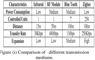
The global position satellite system (GPS) has revolutionized navigation and position location. A GPS receiver calculates its position by precisely timing the signals sent by GPS transmitter. We used this GPS for navigation and positioning in outdoor locations. To design proper communication channel in the indoor locations or to establish a channel across a area which is covered by large number of crowd GPS is not a wise choice due to complexity in design and cost. Often use of GPS at indoor locations results poor performance because of its lack of ability to transmit or receive signal across concrete beacon buildings and civil architectures. Use of small fluorescent-light based sensors resolves this problem, but use of these time of sensors limited to day time only. To relay the project more , we have selected RF communication for indoor communication because of its low power consumption which satisfies mobile applications. Its medium bit rate is enough for navigation and positioning purpose. The comparison of different types of transmission techniques is shown in figure 1, with considerable parameters.
Figure (i) Comparison of different transmission mediums
current location with advanced information from the database which we have already provided for particular location adds artificially generated data along with the real world which is a concept of AR system. The system can detect which signal (GPS or indoor light) is being received and tracking can be continues from the outdoor to indoor by simply switching from an outdoor GPS system to the indoor light sensor or RF sensor system. When the user enters into the location indoor information is provided by continues position information from the outdoor to the indoor environment.
II. SYSTEM DESIGN - HARDWARE
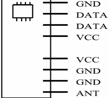
For navigation communication we used a RF signal generator, to get maximum coverage area and to serve during night time also. This hardware circuit can be embedded into a tiny watch to provide more usability to the user. We used ST-TX01-Ask as a RF transmitter. The ST-TX01-ASK is an ASK Hybrid transmitter module. ST-TX01-ASK is designed by the Saw Resonator, with an effective low cost, small size, and simple-to-use for designing. It has Frequency Range: 315 / 433.92 MHZ and Supply Voltage: 3~12V. Use of watch is helpful to display updated time, so that user can record the particular place at the given time. This type of system implementation is very much useful for pilgrims to guide the new location themselves. The STR-433 is ideal for short-range remote control applications where cost is a primary concern. The receiver module requires no external RF components except for the antenna. It generates virtually no emissions, making FCC and ETSI approvals easy. The super-regenerative design exhibits exceptional sensitivity at a very low cost. The manufacturing-friendly SIP style package and low-cost make the STR-433 suitable for high volume applications. The PIN diagram of RF transmitter is shown in the figure (ii). A typical transmitter has power supply, ground and Antenna. Other ports are used to send data. In real this RF transmitter should connect with encoder circuit.
Figure (ii) RF Receiver PIN diagram
A.RF Transmitter:
The below figure (iii) shows interfacing of RF transmitter to HT 12E, which is a 212 The 212 encoders are a series of CMOS LSIs for remote control system applications. They are capable of encoding information which consists of N address bits and 12-N data bits. Each address/data input can be set to one of the two logic states. The programmed addresses/data are transmitted together with the header bits via an RF or an infrared transmission medium upon receipt of a trigger signal. The capability to select a TE trigger on the HT12E or a DATA trigger on the HT12A further enhances the application flexibility of the 212 series of encoders. The HT12A additionally provides a 38 kHz carrier for infrared systems.
Figure (iii) (a) RF Transmitter module
Figure (iii)(b) Interfacing HT 12E t RF Transmitter
B.RF Receiver:
RF transmitter modules are to place at different locations, where they are useful to send the information. The user has RF receiver to receive the data. The RF receiver module is shown in figure (iv). This includes a step down transformer, a rectifier with filter to reduce noise.
Figure(iv) (a) RF Receiver Module
Figure(iv) (b) RF Receiver Module snap
C. System Integration:
We used PIC microcontroller as a processor to elevate this project due to its design feasibility. The conceptual diagram of the entire project is shown below using PIC microcontroller. A RF receiver and GPS Receiver both are interfaced with Controller for indoor and outdoor respectively.
Figure(v) Conceptual Diagram
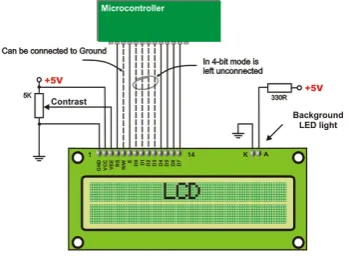
Working of the hardware mentioned above is correlated with the algorithm shown in fig(vii) .to interface LCD as a output display device, first we need to interface LCD
with the microcontroller. This type of configuration is shown in the below figure (vi).
Figure (vi) LCD Interfacing with microcontroller
When user move from one block to another block the RF receiver receives signals of nearest RF transmitter and according to the reception name of the location displays on the LCD. We can also execute this task by providing a database with all pre located names matched with the custom RF transmitter values. So that whenever the receiver checks the received value it compares the already existed value in the database. If the related value is exactly matches with the data base content then the location name is displayed otherwise user will get a suggestion to move forwarded. Providing this information from the data base is useful to represent the content representation very effectively using augmented reality. System designed in this way is very much useful for visitors or tourists or at theme parks. This system will also work as a self expiatory at museums which reduces human effort to a great extent.
III. SYSTEM DESIGN -SOFTWARE
The functionality of the sytem proposed is defined through this algorithm in the fig(viii). It shows two ways of checking the information siganl. Since the aim is to display the correct lcoation information, it uses two trasmision modules checks one by one to avoid use of differet module for outdoor ocations. By providing two checks in the same module allows us to use of same device at in dooor as well as outdoor. Receiver of the user’s devide checks the possible input signal of which RF is the priority.Whenever the receiver gets the RF signal as input, it directly cheks with database and displys the information accordingly. If receiver doesn’t get RF signal then it chekcs the GPS signals. This is useful for outdoor location navigation and positioning.
Figure(vii) Navigation System Software functionality
This below code snippets describe LCD module interfacing with the microcontroller. Related LCD pin configuration is shown in the figure (vi). Other code snippet below shows the serial communication establishment.
A. Serial data reading:
unsigned char recvmsg()// serial reading { unsigned char x;
while((U1LSR&0X01)!=0X01); //checking for character form com1
x=U1RBR; //store the character to variable x return x;}
So this program enabled the data sending through the serial communication. Before sending the data serial port we need to enable serial port. For this a communication protocol must be defined. This is shown as below.
//enable serialport1(serialport1,open()) buf(0) = "!"//declare as char SerialPort1.Write(buf, 0, buf.Length) tx = TextBox1.Text//where we enter the text buf = tx.ToCharArray()
SerialPort1.Write(buf, 0, buf.Length)
B. LCDs interfacing:
void lcdinit1(unsigned int x)// to send commands
{ IOCLR0=0x00FFFFFF; IOSET0=x; //IOSET0=IOSET0<<16;
IOCLR0=0x00004000; //RS // IOSET0=x; IOSET0=0x00008000; //EN
delay(); IOCLR0=0x00008000;} //EN void lcddata1(unsigned char y)// to send data
{ IOCLR0=0x00FFFFFF; IOSET0=y; // IOSET0=IOSET0<<16;
IOSET0=0x00004000; //IOSET0=y; IOSET0=0x00008000; delay(); IOCLR0=0x00008000;}
Here we have use 2x16 LCD to interface. This technique involves the initialization of LCD and sending the data by using 8 data lines.
GPS module interface to the microcontroller enables it to use at outdoor locations.
The entire system design includes analysis of communication requirements and design of reliable hardware for communication approach with defined software functionalities. We used keil software for software side. This project has advantages like more accuracy with less cost, and can be easily embedded into mobile, very much useful for guidance applications.
IV. APPLICATIONS
1. Useful for pilgrims when visiting new places.
2. Intercity public transporters like buses, metro trains can use this for public information purpose.
3. Works as self explainer at museums and art galleries. 4. Useful for information broadcasting at military
services
5. With advance augmentations, these are very useful at Entertainment and Education side.
6. Useful at Industries and civil constructions for supervising and security monitoring.
V.POSSIBLE ENHANCEMENTS
The possible enhancement for this work is adding extra hardware which supports high end AR. this includes again development of AR software. use of high end ARM processor for this work automatically enables users to use this applications. Software application design having the functionalities like automatic GPS recognition, indented content search etc. simplifies this process. So design of UI with enhanced functionalities like stated previous useful for more User interaction to system applications.
ACKNOWLEDGMENTS
Tadepalligudem for his continuous encouragement and support
REFERENCES
[1] Augmented-Reality Maps at TED by Blaise Aguera
[2] An introduction to Augmented Reality with applications in aeronautical maintenance
[3] Hincapie, M.; Caponio, A.; Rios, H.; Mendivil, E.G.; Transparent Optical Networks (ICTON), 2011 13th International Conference on Digital Object Identifier: 10.1109/ICTON.2011.5970856 Publication Year: 2011, Page(s): 1 - 4
[4] A Survey of Augmented Reality Ronald T. Azuma Hughes Research Laboratories
[5] A novel light sensor based information transformation system for indoor positioning and navigation by Adrien david cheok and Li Yue. IEEE conference 2010
[6] The study and improvement of augmented reality based on feature matching
[7] Ruobing Yang; Software Engineering and Service Science (ICSESS), 2011 IEEE 2nd International Conference on Digital Object Identifier: 10.1109/ ICSESS.2011.5982388 Publication Year: 2011 , Page(s): 586 – 589
[8] Augmented Reality for maintenance and Repair by Steve Henderson and Steven Feiner
[9] GPS positioning performance in the wake of the Halloween 2003 geomagnetic storm
[10] Filjar, R.; Kos, T.; Cicin, V.; ELMAR, 2008. 50th International Symposium Volume: 2 Publication Year: 2008 , Page(s): 385 - 388 [11] Indoor GPS theory & implementation van Diggelen, F.; Position
Location and Navigation Symposium, 2002 IEEE Digital Object Identifier: 10.1109/PLANS.2002.998914 Publication Year: 2002 , Page(s): 240 - 247 Cited by: 5
[12] National Research Council (U.S.). Committee on the Future of the Global Positioning System; National Academy of Public Administration (1995). The global positioning system: a shared national asset : recommendations for technical improvements and enhancements. National Academies Press. p. 16.ISBN 0-309-05283-1., Chapter 1, p. 16
[13] Compact low-cost non-RF communication solutions for unmanned ground vehicles
[14] Chand, N.; DeLuck, T.; Andrew, J.H.; Eteson, B.M.; Daniel, T.M.;
Carlson, R.T.; MILITARY COMMUNICATIONS
CONFERENCE, 2010 - MILCOM 2010 Digital Object
Identifier: 10.1109/MILCOM.2010.5680178 Publication Year: 2010 , Page(s): 1577 – 1582
[15] Emerging Technologies of AR Design and Implementation by Michel Haller and Bruce H thoms, upper Austria university of applied science, Austria IDEA group publication, Siganpore [16] RF transmitter design of transceiver for wireless communications
by Qizheng Gu Springer, 2005 edition2.