Volume 8, No. 5, May – June 2017
International Journal of Advanced Research in Computer Science RESEARCH PAPER
Available Online at www.ijarcs.info
GPU Assisted Water Area Mapping using Morphology and Image Segmentation
N. K. Ingle
Department of Electronics
Dr. Annasaheb G. D. Bendale Mahila Mahavidyalaya Jalgaon, India
Abstract: India with the second largest population of world is under the threat of severe water scarcity, the major portion of India’s fresh water requirement is completed by rivers, rivers play very important role in providing drinking water, irrigation water, electricity, transportation and other miscellaneous works has been done with the help of rivers, in order to fulfill increasing demand for water, India needs to make clever use of all sources of water. Mapping water area of river system helps to identify the availability of water in the specific region of a river, an attempt is made to map or highlight the water area in aerial images of river, the image processing tools like morphology and segmentation is used to detect and map water areas. To enhance the computing performance GPU-accelerated computing techniques and two different NVIDIA’s graphics processing units are used. The complete work is done on actual images of Godavari River at Nasik region of Maharashtra.
Keywords: image processing; thresholding; segmentation; gpu computing; compute capability.
I. INTRODUCTION
Water shortages in all form are emerging very fast and India is experiencing similar shortages. Meanwhile, India’s supply of water is rapidly dwindling due primarily to mismanagement of water resources, although over-pumping and pollution are also significant contributors. Climate change is expected to exacerbate the problem by causing erratic and unpredictable weather, which could drastically diminish the supply of water coming from rainfall and glaciers [1]. To overcome this issue India needs proper management of water, although India is blessed with unparalleled resources of lakes, reservoirs, rivers, ponds and wetlands. In India, rivers have been the lifelines of growth and culture, India is drained by some major river systems with a number of smaller rivers and streams. Major river systems in the north are the Himalayan Rivers – Ganga, Yamuna, Indus and Brahmaputra. South has the Krishna, Godavari, and Cauvery while central India has the Narmada, Mahanadi and Tapti. Thus, mapping, exploration, and monitoring of Rivers is necessary for the availability, accessibility, fair utilization, and management of water.
Many image processing and analysis techniques have been developed to aid the interpretation of remote sensing images and to extract as much information as possible from the images. Remote Sensing refers to the science of identification of earth surface features by measuring the portion of reflected or emitted electromagnetic radiation from earth’s surface by sensors onboard manmade satellites orbiting around the earth. The output of a remote sensing system is usually an image representing the scene being observed. Many further steps of digital image processing and modelling are required in order to extract useful information from the image, suitable techniques are adopted for a given theme, depending on the requirements of the specific problem [2]. Although digital analysis of remotely sensed data dates from the early days of remote sensing, the launch of the first Landsat earth observation satellite in 1972 began an era of increasing interest in machine processing. Previously, digital remote sensing data could be analysed only at specialized remote sensing laboratories. Specialized equipment and trained personnel necessary to conduct routine machine analysis of data were not widely
available, in part because of limited availability of digital remote sensing data and a lack of appreciation of their qualities [3].
The river area selected for water bodies mapping is of Godavari river at Nasik district in Maharashtra state of India. Godavari River is sacred river of central and south-eastern India, One of the longest rivers in India, its total length is about 1,465 km, and it has a drainage basin of some 313,000 square km. The Godavari River rises in north-western Maharashtra state in the Western Ghats range, only about 80 km from the Arabian Sea, and flows for most of its course generally eastward across the broad plateau of the Deccan peninsular India. After traversing central Maharashtra it enters northern Telangana state north-west of Nizamabad and continues through a broad valley and, for a short stretch, forms the border with Madhya Pradesh state to the north. The river then turns south-eastward for the last 320 km of its course, flowing through a gap in the Eastern Ghats ranges and then across Andhra Pradesh state before reaching th temples and ghats on the banks of Godavari have made Nasik one of the holiest places for Hindus all over the World. The very popular Hindu fair Kumbh-mela/Fair of Nasik is periodically organised at river basin. Agriculture and agriculture related business is the main source of livelihood for Nasik people, Nasik is the largest producer of grapes. The Nasik district has 29 wineries in operation and consequently Nasik is occasionally known by the epithet “The Wine Capital of India” [6].
Due to the holistic and agricultural importance of Godavari River at Nasik, the mapping of water areas in the river basin becomes a crucial and important task.
II. MORPHOLOGY AND SEGMENTATION
A. Morphology
analysis. In image processing, it is used to investigate the interaction between an image and a certain chosen structuring element [5]. Mathematical morphology, which started to develop in the late 1960s, stands as a relatively separate part of image analysis. Mathematical morphology uses the concept of mathematical set theory for extracting meaning from the image. The basic operations involved in the morphological process are erosion, dilation, opening and closing. The dilation operation thickens the image. The extent of how much it should be thicken is based on the structuring element, where structuring element is a part of the image, the structuring element represents a shape; it can be of any size and have arbitrary structure that can be represented by a binary image. The erosion operation performs either shrinking or thinning of the object. The extent of this operation is decided by the structuring element. Erosion followed by dilation creates an important morphological transformation called opening. The opening of set A by structuring element B is defined by
Opening operation can get rid of small portions of the region that jut out from the boundary in to the background region and Dilation followed by erosion is called closing. The closing of set A by structuring element B is defined by
Closing operation can close up internal holes in a region and eliminate “bays" along the boundary [7,12].
B. Segmentation
Image segmentation is an important step for many image processing and computer vision algorithms. Image segmentation partitions an image into distinct regions containing each pixel with similar attributes; it deals with the procedure for separating out different parts from an image. Meaningful segmentation is the first step from low level image processing transformation a gray-scale or colour image into one or another image to high level image description in terms of features and objects and scenes. Image segmentation is motivated by applications over a wide spectrum of topics. For example, analyzing different regions of an aerial photo is useful for understanding plant/land distribution. Extracting an object of interest from background of an image is important for building intelligent machines for factory automation systems. Segmenting and counting blood cells from cell images can help haematologists to improve diagnosis of diseases. Scene segmentation is also helpful to retrieve images from large image databases for content-based image retrieval system[8, 9]. Mathematical morphology and image segmentation are very important tools for extracting useful information from satellite images and aerial images.
III. GPU COMPUTATION
GPU-accelerated computing is the use of a graphics processing unit (GPU) together with a CPU to accelerate deep learning, analytics, and engineering applications. Pioneered in 2007 by NVIDIA, GPU accelerators now power energy-efficient data centres in government labs, universities, enterprises, and small-and-medium businesses around the world. They play a huge role in accelerating applications in platforms ranging from artificial intelligence to cars, drones, and robots [10].
NVIDIA GPUs (Graphics Processing Units) power millions of desktops, notebooks, workstations and supercomputers around the world, accelerating computationally-intensive tasks for consumers, professionals, scientists, and researchers. A GPU is a processor designed to accelerate the computation of
graphics operations. The term GPU is often used in contrast or comparison with central processing unit (CPU), GPUs are placed on graphics boards where they are used to speed up 3D graphics rasterization, the task of taking an image described as a series of shapes and converting it into a raster image for output on a video display. This process can be controlled using small programs called shaders. The shader instruction set has evolved over the years to the point that it is now possible to use GPUs for general purpose computations. GPU computing started as an effort by the scientific community to exploit the raw processing power of GPUs to make intensive computations. In fact, the power of the most recent GPUs is comparable to the computational power of a cluster with hundreds of CPU cores [13]. The purpose of using GPU for computation is to reduce or alter the execution time and to manage huge data required to process images. The GPU with CUDA (Compute Unified Device Architecture) parallel computing architecture will provide compelling benefits for data mining applications. In addition, its superior floating-point computation capability and low cost will definitely appeal to medium-sized business and individuals [11]
IV. EXPERIMENTAL WORK
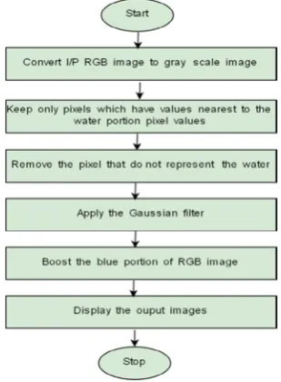
[image:2.595.363.518.545.755.2]Two different algorithms for master CPUs and host GPUs are designed. Proposed algorithm uses the segmentation and mathematical morphological to extract water areas from aerial images. Identifications and mapping of the surface water have been one of the simplest and direct applications of the remote sensing in water resources studies. Remote sensing of water resources is based on the difference in spectral reflectance of land-surface and water area. Water absorbs most of the energy in Near-Infrared Region and Mid-Infrared Region wavelengths, whereas surface vegetation and soil have a higher reflectance in these wavelengths. Thus, in a multi-spectral image, water appears darker in the Infrared bands and can be easily differentiated from the land and surface vegetation , in general water areas and wetlands have the low reflection in near-infrared bands of remote sensing images and vegetation has the high reflection. So water areas are always appearing in the near-infrared images. Thus the gray-level intensity value of the water is the smallest and vegetation area is the greatest and the rest intensity values of the land area are higher than the river and smaller than vegetation area.
The proposed algorithm for water mapping using CPU is shown in Fig. 1, Fig. 2, 7 and 9 shows the input images, all input images are RGB jpeg color images; the given input images are first converted to gray-level and then the morphological operations are performed. The pixel intensity of water area is detected; water area has different pixel intensity value than surrounding objects. The pixel intensity is a single number that represents the brightness of the pixel. Thresholding method is applied to each water representing pixel, after thresholding process the water representing pixel in an image is converted to white pixel, thresholding is the simplest method of image segmentation. Thresholding can be used to create binary images, binary images are having only two pixel value ‘1’ and ‘0’ which represents white and black colors, Consider G(x, y) is the gray-scale pixel and T is the threshold value, then the binary image B(x, y) can be obtained
The morphological area opening operation is performed on binary image; opening removes small objects from the foreground usually dark pixels of an image. The motion blur in the image is created by applying Gaussian low pass filter. At the last step by using linear combination of images the blue part of RGB image is enhanced and water area is highlighted.
The GPU algorithm requires sending data form CPU to GPU before the application of morphology and segmentation to the input data; after placing the data in to the GPU memory, GPU uses its massively parallel cores to process the algorithm.
V. RESULTS AND DISCUSSION
The proposed algorithm shown in Fig. 1 is executed on two different CPUs and GPUs. The CPUs used for processing are Intel Core i5-5200U Processors made for mobile devices running at maximum frequency of 2.70GHz having 2 cores, 4 threads and 25.6 GB/s memory bandwidth [14]. Intel Core i3-6100 Processors made for desktop computing devices running at maximum frequency of 3.70GHz having 2 cores, 4 threads and 34.1 GB/s memory bandwidth [15]. The GPUs are NVIDIA GeForce GTX 920M, GTX 920M is based on 28nm Kepler GK208 architecture and operating at 575MHz;
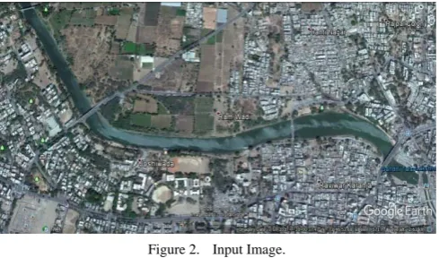
Three different images of Godavari river basin and nearly 7.0 square km area of Nasik city is considered for water area mapping. The input images are taken from “Map data: Google, DigitalGlobe”.
[image:3.595.312.557.53.197.2]It features 384 CUDA cores, 2,048 MB DDR3 memory, which are connected using a 64-bit memory interface and memory bandwidth is 14.4GB/s [16]. The second GPU is NVIDIA GeForce GTX 750Ti, 750Ti is a gaming performance graphics card, built on Maxwell architecture, and based on the 700 series graphics processor. It features 640 CUDA cores, NVIDIA has placed 2,048 MB GDDR5 memory on the card, which are connected using a 128-bit memory interface. The GPU is operating at a frequency of 1020MHz and can be boost up to 1085MHz of clock frequncy. Memory bandwidth of GTX 750Ti is 86.4 GB/s both the GPUs are having different architectures and are made for very different application, GPU GTX 920M is made for portable computing devices and GTX 750Ti is intended for gaming desktops and personal computers[17].
Figure 2. Input Image.
[image:3.595.307.554.251.385.2]The input image for designed algorithm is shown in Fig. 2. The image is of 1280 by 610 RGB color image, water representing pixels values are detected and threshold is applied to generate binary image shown in Fig. 3
[image:3.595.307.554.403.542.2]Figure 3. Binary Image for Fig. 2
Figure 4. Morphologically Open image
[image:3.595.314.556.614.746.2]Fig 4. is an eroded and dilated image, which obtained after morphologically opening the binary image shown in Fig. 3, opening removes the white portion which does not represents the water.
Figure 5. Filtered and Blurred Image
If
G(x, y) > T Then
B(x, y) = 1 Else
Fig. 5 is obtained by applying the Gaussian low pass filter and blur filter to the morphologically opened image shown in Fig. 4, Gaussian low pass filter and blur filter is generally used to remove noise from the images.
Figure 6. Output
Final output image is shown in Fig. 6; it shows water area which is represented blue color, the blur filtered portion shown in fig. 5 is enhanced to blue color to show the water area.
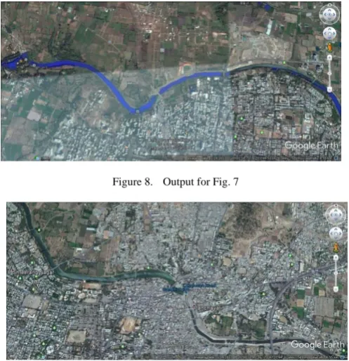
Figure 7. Input Image.
[image:4.595.41.286.311.445.2]The other input images taken from various location across river is shown in Fig. 7 and Fig. 9 both the images are 1210x610 RGB color images and their corresponding outputs are shown in Fig. 8 and Fig. 10.
[image:4.595.37.286.511.768.2]Figure 8. Output for Fig. 7
Figure 9. Input Image.
Figure 10. Output for Fig. 9
VI. CONCLUSION
The goal of this work is to map water area across the Godavari river basin in Nasik City using parallel computation power of some GPUs. The mapping of water is necessary task to predict availability of water in particular area of river. The designed algorithm is tested on two different GPUs, NVIDIA GeForce GTX 920M and NVIDIA GeForce GTX 750Ti both are having different compute capability, the compute capability of GTX 920M is 3.5 and 5 is for GTX 750Ti and both the GPUs accelerates the designed algorithm up to 2 to 3 times faster than host CPUs. For future work the high performance computing indented GPUs like NVIDIA Tesla or Quadro products can be used to achieved maximum computing acceleration.
VII. ACKNOWLEDGMENT
The author express his gratitude towards the Dr. S. J. Sharma, Head, Department of Electronics, R.T.M. Nagpur University Nagpur, M.S., India for providing research facilities and encouragements. The author wish to record thanks for Mr. Sanjiv U. Dubey, VNIT, Nagpur and staff members of Dr. Annasaheb. G. D. Bendale Mahila Mahavidyalya, Jalgaon (M.S.), India.
VIII. REFERENCES
[1] P. Mehata, “Impending water crisis in India and comparing clean water standards among developing and developed nations,” Arch. Appl. Sci. Res., Vol. 4, Issue 1, pp.497-507, 2012
[2] M. Kumar and R. K. Singh, “Digital Image Processing of Remotely Sensed Satellite Images for Information Extraction,” Proc. Conference on Advances in Communication and Control Systems, pp 406-410, 2013
[3] M. Kumar, “Digital Image Processing,” Proceeding of Training Workshop on Satellite Remote Sensing and GIS Applications in Agricultural Meteorology, pp. 81-102, 2003
[4] Godavari River <https://www.britannica.com /place/ Godavari-River >
[5] U. Rani and Nitasha, “Image Segmentation using Mathematical Morphology : A Study,” International Journal of Advanced Research in Computer Science, Volume 7, No. 6 (Special Issue), pp.208-210, November 2016.
[6] On a wine trail in Nashik
<http://www.business- standard.com/article/beyond-business/on-a-wine-trail-in-nashik-115012301431_1.html>
[image:4.595.286.560.527.782.2][8] J. Harikrishna, D. P. Kondisetty, G.S. Chaitanya Kumar and K.P. Venkata Kumar, "Higher Image Segmentation in Low and High Pass Areas," International Journal,of Advanced Research in Computer Science, Volume 6, No. 3, pp. 73-76, May 2015. [9] R. Sharma and R. Bhupinder Kaur, "A Review on Image
Segmentation for Medical Images," International Journal of Advanced Research in Computer Science, Volume 7, No. 6, pp. 235-237, November 2016.
[10] Accelarated Computong < http://www.nvidia.com/ object/ what-is-gpu- computing.html#sthash.TCZF2s4R.dpuf>
[11] V. Dhamdhere and R. Ghudji, "K-Means on GPU - A Review," International Journal Of Engineering And Computer Science, Volume 3, Issue 5, pp. 5500-, May 2014.
[12] R. C. Gonzalez and R. E. Woods, Digital Image Processing, 2nd ed., Prentice Hall, 2002, pp. 550.
[13] L. Dematte and D. Prandi, “ GPU Computing for Systems Biology, ” Briefings in Bioinformatics, Volume 11, Issue 3, pp. 323-333, March 2010,
DOI: https://doi.org/10.1093/bib/bbq006
[14] Intel Core i5-5200U Processor < http://ark.intel.com/ products /85212 /Intel-Core-i5-5200U-Processor-3M-Cache-up-to-2_70-GHz>
[15] Intel® Core™ i3-6100 Processor<https://ark.intel.com/ products / 90729 /Intel-Core-i3-6100-Processor-3M-Cache-3_70-GHz>
[16] NVIDIA GeForce 920A <https://www.techpowerup.com/ gpudb / 2647 / geforce-920a>
[17] GeFocre GTX 750Ti < http://www.geforce.com/ hardware / desktop-gpus / geforce-gtx-750-ti / specifications >