I
nternational
J
ournal of
I
nnovative
R
esearch in
S
cience,
E
ngineering and
T
echnology
(An ISO 3297: 2007 Certified Organization)
Vol. 4, Issue 5, May 2015
ISSN(Online): 2319 – 8753 ISSN (Print) :2347 - 6710
Proposal Sites for Spent Fuel Disposal in
Egypt by Using GIS Program
Magda M. Abdellatif
1, Nadia. M.Sirag
2Lecturer, Department of Material and Nuclear Fuel Cycle, NARRA
1Lecturer, Department of Site and The Environment, NARRA
2Nasr City, Cairo, Egypt
ABSTRACT: The present study uses Geographic Information System(s) (GIS) as a spatial decision support tool to
select potential sites in Egypt for deep geological disposal for spent radioactive fuel. A specific weight is given to each criterion according to its relative influence on the process of decision making. The results from the application of the presented methodology determine the relative suitability of sites for deep disposal of radioactive wastes. These sites are ranked in descending order to help decision-makers
in Egypt. The present study aims to provide a baseline
for more detailed technical analyses for the selected sites.
KEYWORDS: Deep Geological Disposal, GIS, Spent Fuel Disposal, Western Desert of Egypt.
I. INTRODUCTION
There exists today an international consensus on the appropriateness and capability of deep geologic disposal to provide long-term isolation of used fuel and HLW from the biosphere. This consensus has emerged from more than five decades of scientific study and peer-review, technical and regulatory developments, and site selection and characterization.
International efforts over the last half-century toward disposal of high-level waste and spent nuclear fuel have primarily focused on mined repositories. Nonetheless, evaluations of deep borehole disposal have periodically continued in several countries [O‟Brien et al., 1979; Woodward and Clyde Consultants, 1983; Juhlin and Sandstedt, 1989; Heiken et al., 1996; NIREX, 2004; Anderson, 2004; Gibb et al., 2008].
After many researches in different countries it was concluded that geological disposal remains the only scientifically and technically credible long-term solution available to meet safety needs without reliance on active management and there is overwhelming international consensus on geological disposal as preferred option.
Egypt has recently initiated plans to build nuclear power reactors. This program will eventually have to deal with spent fuel and high level waste disposal, as will be seen, deep borehole disposal is a promising approach. On the other hand spent fuel from the research reactor in Egypt stored near the reactor waiting for final solution. As well as the high-level wastes generated from RPF (Radioisotopes Production Facility). At the present early stage of the deep geological repository programme in Egypt, no repository site has been selected, nor has any particular kind of sites been specified as a preferable repository host rock. Therefore, this paper aims to specify generic sites in Egypt by using the previous field studies and GIS program. The potential geological formation properly characterized elsewhere in the world; salt, clay, volcanic tuff, granite and crystalline rocks; most of them are present in Egypt.
I
nternational
J
ournal of
I
nnovative
R
esearch in
S
cience,
E
ngineering and
T
echnology
(An ISO 3297: 2007 Certified Organization)
Vol. 4, Issue 5, May 2015
ISSN(Online): 2319 – 8753 ISSN (Print) :2347 - 6710
were then reviewed. The list was then screened to remove environments where all of the examples in Egypt would definitely be excluded by the general safety criteria [8]. This would be the first step as the potential sites chosen will be need technical and detailed investigation to insure the safety requirements. The main goal of the present study is an attempt to determine the potential sites for spent fuel disposal in Egypt.
Egypt is situated in the northeast of the African. It has an area about 1001449 km2 and occupies nearly one-thirtieth of
the total area of Africa. Without the Nile Valley and Delta, Egypt is mainly a desert country [9].
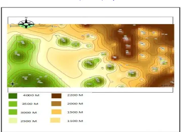
Fig .1. Geological Map of Egypt (Schlumberger, 1984).
Geographically, the country is composed of several distinct regions; The Sinai Peninsula covers an area of some 61,000 km². The Gulf of Suez covers an area of about 25,000 km². It extends along a northwest trend from latitude 27°30„N to 30°N. The Eastern Desert embraces the area is about 22% of the total area of Egypt. The Nile Valley and Delta form the alluvial system that stretches for 1530 km². It contains the rich agricultural and industrial area of Egypt and is also the most densely populated part of the country. The Western Desert, with its 680,000 sq km covers more than 65% of entire Egypt. Geomorphologically, it is stone desert plateau with numerous large and deep, closed topographic depression. [Sestini, 1995] Figure [1] shows the geological map of Egypt representing wide range of different geological depositions from the Quaternary deposits to the Precambrian intrusions. These deposits varied from unconsolidated sand dunes to hard igneous rocks. The western desert represents generally wide area of plain plateau with five depressions.
II. GENERAL GEOLOGICAL SETTING OF EGYPT
Structurally, Egypt can be divided into two main divisions: the Arabo-Nubian massif and the so-called shelf areas [Said, 1962; Schlumberger, 1984; Said, 1990] The Arabo-Nubian massif is a stable tectonic unit consisting of the exposed basement rocks in the Eastern Desert, in the southern part of the Sinai Peninsula and in isolated outcrops of southern Egypt [Said, 1962; Schlumberger, 1984; Said, 1990].
I
nternational
J
ournal of
I
nnovative
R
esearch in
S
cience,
E
ngineering and
T
echnology
(An ISO 3297: 2007 Certified Organization)
Vol. 4, Issue 5, May 2015
ISSN(Online): 2319 – 8753 ISSN (Print) :2347 - 6710
Mesozoic to Early Tertiary age, deformed by several sets of regional folds [Said 1962; Dorre et al.,1979; Said, 1990].The Unstable Shelf occupies almost all of northern Egypt (the Nile Delta area is part of the unstable shelf), characterized by a northward-thickening sedimentary section underlain by high basement relief due to block faulting. According to review of topographic maps, structural maps, hydrological maps and the previous researches in technical papers Egypt can be classified as follow;
- Areas with low relief; Nile and delta region, north and central of Western Desert and north of Sinai. - Areas with high relief as; Eastern Desert, south of Sinai and part of the southern west of Western Desert. - Areas with fresh water resources; Nile and Delta region and Egyptian Depression (Kharge, Dakhla,
El-frafra, Siwa, Qattara)
- Under ground water source (Nubian Sandstone Aquifer); this great aquifer expand in four countries (Egypt, Libya, Chat and Sudan)
- Areas with relatively high seismic activities; area near and around the Suez Gulf area. - Areas with high population density; Nile and Delta region
According to the hydrological setting as an important criterion the depth of the water table must be taken into consideration as a highly important factor, since we consider deep disposal for spent fuel. The aquifers system in Egypt is classified into two types. The first type is the granular aquifers system, which includes the Nile Valley and Delta aquifer, coastal aquifer, Nubian Sandstone aquifer, and Moghra aquifer [15]. The second type is the fissured aquifer system, which includes the Fissured Carbonate aquifer. It is considered to be one of the poorest aquifers in Egypt. It belongs to different geological ages and consists of shale and sandstone layers. [15].
Nubian Sandstone aquifer has a thickness varying from less than 500 m to more than 3000 m and rests directly on
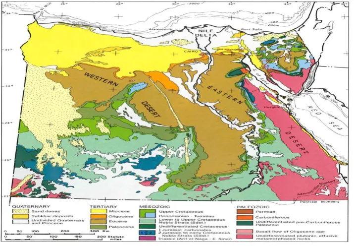
Precambrian basement. [16, 17] The thickness of the Nubian Sandstone is very important factor affecting the choice of a disposal site in Egypt, since this formation is the main source of the underground water source which would be great contribution in the future development in our country. There was a proposal for future development in some locations depending on the water resources represented in Nubian sandstone aquifer [17] since the Nubian sandstone covers the area near the surface in some locations. A large area of about 3.5 million Fadden is able to be developed [18-21]. Figure [2] shows the Nubian Aquifer and the main features of hydrogeology in Egypt; where the water flows of the main aquifer from south to north direction. The direction of water flow is an important factor in the evaluation of waste disposal site. As we see the Nubian deposit thickness decreased from the north to the south and the Nubian Aquifer cover four countries (Egypt Libya, Chad and Sudan).
Fig. 2 Nubian Sandstone Aquifer System.
I
nternational
J
ournal of
I
nnovative
R
esearch in
S
cience,
E
ngineering and
T
echnology
(An ISO 3297: 2007 Certified Organization)
Vol. 4, Issue 5, May 2015
ISSN(Online): 2319 – 8753 ISSN (Print) :2347 - 6710
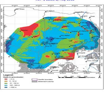
Fig. 3. Depth to Groundwater in 1960 (finite element model) (after Gossel et al., 2004).
Figure [3] represented the depth to ground water; accordingly the water presents at different depths which increases southward, where the desert is hyper arid environment especially the south west region. The Nubian Sandstone formation lies directly on basement rock formation. The depth of the ground water, increases greatly in Gulf el-Kabir area; south west of the western desert. In some location the ground water presents near the surface as in the Depressions.
Seismic activity is an important criterion; the more stable area is the safer site for disposal. Earthquakes are the most
evident manifestations of the currently occurring bedrock deformation; the seismic activity is very low and is concentrated offshore near and around the Suez Gulf area [23]. On this respect and as the most economically oil field is situated there, Suez Gulf area in eliminated from consideration. So the same will be for Sinai area as it is highly affected by the regional forces related to the Gulf of Suez, and Red Sea tectonics.
III. APPROACH TO IDENTIFYING GEOLOGICAL ENVIRONMRNTS
I
nternational
J
ournal of
I
nnovative
R
esearch in
S
cience,
E
ngineering and
T
echnology
(An ISO 3297: 2007 Certified Organization)
Vol. 4, Issue 5, May 2015
ISSN(Online): 2319 – 8753 ISSN (Print) :2347 - 6710
COUNTRY
GEOLOGIC ENVIRONMENTS CONSIDERED OR INVESTIGATED
United States Salt, basalt, granite, tuff, clay, and shale
Belgium Clay and shale
Canada Granite and sedimentary rock China Granite
Finland Granite, gneiss, grandiorite, and migmatite
France Argillite and granite Germany Salt
Japan Granite and sedimentary rock Republic of Korea Granite
Spain Granite, clay, and salt Sweden Granite
Switzerland Clay and granite United Kingdom No decision made.
Table [1] Disposal of Spent Nuclear Fuel and High-level Radioactive Waste [24]
IV. METHODOLOGY
Acceptable Generic Sites: A generic site is one that is well-suited to the task at hand and also widely available
geographically and geologically. In general, granitic bedrock overlain by an average (but highly variable) two km or so of sedimentary rock is widely present in Egypt. This suggests consideration of sites having about one kilometer of sedimentary overburden. Furthermore, we adopt the common practice of designating igneous continental bedrock as “granitic,” even though it may be in its metamorphosed form of gneiss or in its glassy version of a rapidly-cooled rhyolite. The key attribute of all is their exceptionally low permeability with regard to water transport. On-land basalts however should be considered as an alternative host rock.
In Shales and Argillaceous media potential host formations, a repository site could readily be located with attributes
such as those identified by Shurr [1977]:
- Depth – The specific isolation horizon should be from 300 to 900 m below surface.
- Shale thickness – Maximum thickness of the isolation medium is desired, while a minimum thickness of 150
m is preferred.
- Overburden thickness – Minimal thickness of overlying geologic units is preferred.
- Lithography and mineralogy – The potential repository interval should be reasonably uniform clay or shale.
- Penetrations (boreholes) – Boreholes of any kind are undesirable, particularly if they penetrate to rocks
beneath the disposal horizon. It is recognized that some holes, either preexisting or bored during detailed search for isolation sites, are necessary to provide geologic information at depth.
- Structure – The disposal zone should have nearly horizontal bedding, with no significant faulting or folding
in the vicinity of the isolation site.
- Seismicity – Preference would be given to regions known to be inactive from recorded
- Topography – Minimal topographic relief is desirable to limit subsurface hydraulic gradients.
- Mineral and water resources – It is undesirable to consider a potential site near exploitable mineral or water
resources, either at or below the surface.
I
nternational
J
ournal of
I
nnovative
R
esearch in
S
cience,
E
ngineering and
T
echnology
(An ISO 3297: 2007 Certified Organization)
Vol. 4, Issue 5, May 2015
ISSN(Online): 2319 – 8753 ISSN (Print) :2347 - 6710
Value Meaning
9 extremely better the highest possible difference
7 much more better very strongly favor one criteria over the other 5 definitely better strongly favor one criteria over the other
3 somewhat better slightly one criteria is more important than the other 1 equal two criteria are equal
Table.2. The Saaty Rating Scale
The highest value means the highest possible favor choice; the low number means the two criteria are equal importance. A number of input criteria are used that influence the choice of waste disposal sites. The first step in the methodology requires the development of a digital GIS database containing spatial information. A number of thematic maps are prepared from topographic maps, hydrologic maps (aquifer depth), seismic map, structural map, population density map, natural resources map, climatic map and previous reports. The thematic maps represent topography, structural, aridity, climatic changes, earthquakes, hydrology (aquifer depth), population density, natural resources… The weight of each factor was based on its estimated significance. Based on the weight of each factor and its class, the input rasters are weighted by importance and added together to produce an output raster. The steps are summarized below:
1. A numeric evaluation scale of 1–10.
2. The cell values for each input raster in the analysis are assigned values from the evaluation scale and reclassified to these values. This makes it possible to perform arithmetic operations on the rasters that originally held dissimilar types of values.
3. Each input raster is weighted, or assigned a percent influence, based on its importance to the model. The total influence for all rasters equals 100%.
4. The cell values of each input raster‟s are multiplies by the raster‟s weights. 5. The resulting cell values are added together to produce the output raster.
In this study number of criteria are used; seismic activities (frequencies, magnitude), hydrology (aquifer depth), rock formations (type, depth), climatic change (aridity index), population density (human activities'), natural resources (future activities). These input criteria are used that influence the choice of sites. AHP (Analytical Hierarchy Process) is a structured technique that helps decision-makers to find a site that best suits their goal and their understanding of the problem.
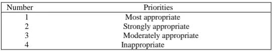
In this paper, ODM based on simple additive weighting criteria were used to support spatial decision making. AHP assists the decision makers to simplify the decision problem by creating a hierarchy of decision criteria that best suits their goal and their understanding of the problem, table [3]. Number one represents the most appropriate choice while number 4 means the choice inappropriate. We arranged the proposed sites according to these numbers. The procedure for using ODM can be summarized as follows: model the problem as a hierarchy containing the decision goal, the options for reaching it, and the criteria for evaluating the options; establish priorities among the elements of the hierarchy; synthesize these judgments to yield a set of overall priorities for the hierarchy; check the consistency of the judgments; come to a final decision based on the results of this process [25].
Table 3. Relation Between Priorities and Number In AHP Rating Procedure
Number Priorities 1 Most appropriate 2 Strongly appropriate 3 Moderately appropriate 4 Inappropriate
I
nternational
J
ournal of
I
nnovative
R
esearch in
S
cience,
E
ngineering and
T
echnology
(An ISO 3297: 2007 Certified Organization)
Vol. 4, Issue 5, May 2015
ISSN(Online): 2319 – 8753 ISSN (Print) :2347 - 6710
Fig. 4. The Basement Depth for the Proposed Disposal Sites In Egypt
V. RESULTTS
Rock types in Egypt: From the review of the previous technical science paper concerning the stratigraphic cross
section and tectonic structural in Egypt and according to the suitability of certain rock formation for radioactive waste disposal (salt, clay formation, tuff and granite) and the acceptable generic site we found that:
Salt deposits are found in different formations, major occurrences of salt dome in different countries are found along
the gulf coast, these formations are not found in our land. Usually salts in Egypt are formed as sheets on surfaces of land near the coastal areas.
Tuff rocks; the volcanic and volcaniclastic rocks covering vast areas in the Eastern Desert of Egypt are represented by
metavolcanics and Dokhan volcanics. The Dokhan volcanics are most abundantly occurring in the Northern part of the Eastern Desert of Egypt and related to Late Proterozoic products of the Pan-African volcanism in the Nubian Shield. These Dokhan volcanic rocks constitute agroup of calc-alkaline extrusion and well developed in various parts of the Eastern Desert. [26,27]
Clay mineral deposits are widely distributed in Egypt, covering all geologic ages span from the early Paleozoic up to the present. Shale is often used as a very general term of all kinds of clay rich sedimentary rocks. Shale are accounting for around 60% of the stratigraphic column. Clay minerals account 50-60% of most shale. In Egypt shale are usually deposited in wide area and various thicknesses. Their thickness range from few centimeters to few hundred meters in different formation (e.g.Khatataba formation, Alam El-Bueib formation, Abu Roash formation). Most shale formation as the Khatatba Formation comprises sandstone and organic-rich shales that show source rock potential for hydrocarbon generation (Alsharhan and Abd El-Gawad, 2008; Shalaby et al., 2011)
Granitic rock, granitoid rocks are widely distributed all over the Egyptian Shield, constituting approximately 60% of
I
nternational
J
ournal of
I
nnovative
R
esearch in
S
cience,
E
ngineering and
T
echnology
(An ISO 3297: 2007 Certified Organization)
Vol. 4, Issue 5, May 2015
ISSN(Online): 2319 – 8753 ISSN (Print) :2347 - 6710
Finally attention has been focus into granitic type rock because of its widespread continental presence (especially if
several hundred meters of sedimentary overburden is tolerable) and its superior physical properties: low porosity and permeability, in particular.
In Egypt the most appropriate area for radioactive waste disposal according to this study would be the south part of the western desert (the most hyper-arid environment) generally between 22⁰ and 26⁰ N Latitude and 26⁰ and 30⁰ E Longitude. In this are there are four potential sites ranking as the following in table [4].
Table 4. The Potential Disposal Site for Spent Fuel In Egypt
Site Name Appropriate
Gulf Kiber plateau 1
Selima sand sheet 2
Abu Ras plateau 3
Abu Balls 4
The four potential sites are located in the western desert of Egypt figure [4]; in the south west part. The depth decreased towards the east and north. The four proposal site located in the south west area in the western desert where the Granitic rocks (basement complex) found in depths between 1100-4000 km. These sites represent one type of rock (granitic rocks). The present study could be considered as a baseline for more detailed technical analyses for the selected sites. As well as we recommended more investigation for the clay formation in Egypt, since it need more investigation as a second choice for radioactive wastes disposal.
VI. CONCOLUSION
The present study uses Geographic Information System(s) (GIS) as a spatial decision support tool to select potential sites in Egypt for deep geological disposal for spent radioactive fuel. The research demonstrated all the geological information in most of the scientific research papers, the geological maps, and the available stratigraphic cross section for different areas all over the country. Aridity, deep aquifers, earthquakes, population density, topography and natural resources are criteria that have been taken into consideration in the process of analysis. A specific weight is given to each criterion according to its relative influence on the process of decision making. The results from the application of the presented methodology determine the relative suitability of sites for deep disposal of radioactive wastes. These sites are ranked in descending order to help decision-makers in Egypt. The present study aims to provide a baseline for more detailed technical analyses for the s
elected sites.
REFERENCES
[1] O‟Brein, M.T, L.H. Cohen, T.N. Narasimhan, T.L. Simkin, H.A. Wollenberg, W.F. Brace, S. Green, H.P. Platt (1979), The Very Deep Hole Concept: Evaluation of an Alternative for Nuclear Waste Disposal, Berkeley, CA, Lawrence Berkeley Laboratory, LBL-7089.
[2] Woodward - Clyde Consultants (1983), Very Deep Hole Systems Engineering Studies. Columbus, OH, ONWI.
[3] Juhlin, C. and H. Sandstedt (1989), Storage of Nuclear Waste in Very Deep Boreholes: Feasibility Study and Assessment of Econ omic Potential. Part I:Geological Considerations. Part II: Overall Facility Plan and Cost Analysis., SvenskKarnbranslehantering AB.
[4] Heiken, G., G. Woldegabriel, R. Morley, H. Plannerer, J. Rowley (1996), Disposition of Excess Weapon Plutonium in Deep Boreho les – Site Selection Handbook. Los Alamos, NM, Los Alamos National Laboratory.
[5] Nirex (2004), A Review of the Deep Borehole Disposal Concept, Report N/108, United Kingdom Nirex Limited.
[6] Anderson, V. K. (2004), An Evaluation of the Feasibility of Disposal of Nuclear Waste in Very Deep Boreholes. Dept. of Nuclear Engineering. Cambridge, MA, MIT.
[7] Gibb, F.G.F., K.J. Taylor, and B.E. Burakov (2008b), The „granite encapsulation‟ route to the safe disposal of Pu and other actinides, J. of Nuclear Materials 374: 364-369.
[8] IAEA SAFETY STANDARDS SERIES No. SSG-14.
[9] Modern Geophysical Techniques for Constructing a 3D Geological Model on the Nile Delta, Egypt, M.Sc. Applied Geophysics ,MoatazKhairy Ahmad Barakat , Berlin 2010 .
[10] Schlumberger (1984): Geology of Egypt pp.1-64. - Paper presented at the Well Evaluation Conference, Schlumberger, Cairo.
[11] Sestini, G., (1995): Egypt. In: Kulke, H. (Ed.): Regional Petroleum Geology of The World, Part II: Africa, America, Australia and Antarctica (Beiträgezr regionalen Geolgie der Erde 22: 66-87), Gebrüder Borntraeger Verlagsbuchhandlung, Stuttgart.
[12] Said, R., 1962. Geology of Egypt.
I
nternational
J
ournal of
I
nnovative
R
esearch in
S
cience,
E
ngineering and
T
echnology
(An ISO 3297: 2007 Certified Organization)
Vol. 4, Issue 5, May 2015
ISSN(Online): 2319 – 8753 ISSN (Print) :2347 - 6710
[14] A. S. DORRE,‟ E. CARRARA,‟ F. CELLA,‟ M. GRIMALDI,‟ Y. A. HADY,2
[15] H. HASSAN,2 A. RAPOLLA‟ and N. ROBERTI‟ „Dipartimento di Geofisica e Vulcanologia, Largo S. Marcellino, 10 – 80138. Naples, Italy, Crustal thickness of Egypt determined by gravity data. Journal of African Earth Sciences, „Jot. 25. No. 3, PP. 425-434, 1997.
[16] Hefny K, Shata A. Underground water in Egypt. Cairo, Egypt: Ministry of Water Supplies and Irrigation; 2004. [17] E. H. Klitzsch., Geological Research In and Around Nubia, EPISODES, vol. 1983, No.3.
[18] Hydrogeology of the Great Nubian Sandstone basin, Egypt Quarterly, Journal of Engineering Geology and Hydrogeology, May 1982, v.15, p. 127-133,
[19] K. A. Ouda, “Atlas of risks of climate change on the Egyptian coasts and defensive policies. Geology of the Nile basin countries conference GNBCC-2012,” in Proc. of 20th- 22nd March 2012, Alexandria, Egypt, pp. 95-103.
[20] K. A. Ouda, Unpublished researches (presented conference), “Fostering sustainable water management and agriculture in Egypt‟s „New Valley‟,” WaDImena Egypt - June 2009.
[21] General organization for physical planning (Gopp). [Online].Available: http://www.gopp.gov.eg/
[22] Somaya T. Abouelfadl, Khaled A. Ouda, Assmaa A. Atia, and Nada Al-Amir. A Primary Master Plan of Gardens‟ City- A New City in Egyptian Western Desert (EGCWD). Journal of Clean Energy Technologies, Vol. 1, No. 2, April 201.
[23] Sayed A. Dahy, Seismic Active Zones and Mechanism of Earthquakes in Northern Egypt European Journal of Applied Sciences 4 (2): 65-71, 2012.
[24] Chris Whipple, Ph.D.1. ENVIRON International Corporation, September 10, 2010.
[25] Shurr, G.W. 1977. The Pierre Shale, Northern Great Plains; A Potential Isolation Medium for Radioactive Waste. United Sta tes Geological Survey Open File Report 77-776.
[26] Saaty TL. A scaling method for priorities in hierarchical structures. J Math Psychol 1977;15(3):234–81.
[27] Hatem M. El-Desoky, Geochemistry and Petrogenesis of Late Neoproterozoic DokhanVolcanics at Wadi Abu Hamra area, Central Eastern Desert, Egypt, Journal of American Science 2013;9(5)
[28] Alsharhan, A.S., Abd El-Gawad, E.A. 2008. Geochemical characterization of potential Jurassic/Cretaceous source rocks in the Shushan Basin, north Western Desert, Egypt. Journal of Petroleum Geology 31, 191–212.
[29] Shalaby, M.R., Hakimi, M.H., Abdullah, W.H. 2011. Geochemical characteristics and hydrocarbon generation modeling of the Jurassic source rocks in the Shoushan Basin, north Western Desert, Egypt. Marine and Petroleum Geology 28, 1611–1624.
[30] M.F. El-Ramly, M.K. Akaad, The basement complex in the central Eastern Desert, Geological Survey Egypt 8 (1960) 35–45 [31] Schlumberger (1984): Geology of Egypt pp.1-64. - Paper presented at the Well Evaluation Conference, Schlumberger, Cairo.
![Table [1] Disposal of Spent Nuclear Fuel and High-level Radioactive Waste [24]](https://thumb-us.123doks.com/thumbv2/123dok_us/1674651.1210856/5.595.156.442.185.355/table-disposal-spent-nuclear-fuel-high-radioactive-waste.webp)