REVIEWARTICLE
Trajectory data mining: A review of
methods and applications
Jean Damascène Mazimpaka and Sabine Timpf
Department of Geography, University of Augsburg, Germany
Received: October 10, 2015; returned: January 27, 2016; revised: July 7, 2016; accepted: September 6, 2016.
Abstract: The increasing use of location-aware devices has led to an increasing availabil-ity of trajectory data. As a result, researchers devoted their efforts to developing analysis methods including different data mining methods for trajectories. However, the research in this direction has so far produced mostly isolated studies and we still lack an integrated view of problems in applications of trajectory mining that were solved, the methods used to solve them, and applications using the obtained solutions. In this paper, we first discuss generic methods of trajectory mining and the relationships between them. Then, we discuss and classify application problems that were solved using trajectory data and relate them to the generic mining methods that were used and real world applications based on them. We classify trajectory-mining application problems under major problem groups based on how they are related. This classification of problems can guide researchers in identifying new application problems. The relationships between the methods together with the as-sociation between the application problems and mining methods can help researchers in identifying gaps between methods and inspire them to develop new methods. This paper can also guide analysts in choosing a suitable method for a specific problem. The main contribution of this paper is to provide an integrated view relating applications of mining trajectory data and the methods used.
Keywords:trajectories, mining methods, mining application problems, applications
1
Introduction
62 MAZIMPAKA, TIMPF
have shown that these data sets constitute a precious resource. Their analysis can lead to solutions for important research problems in different fields such as urban planning, transportation, behavioral ecology, sports scene analysis, surveillance, and security [53].
Researchers in movement analysis have made important contributions by developing methods and tools to solve specific application problems. As researchers continue to ad-dress diverse application problems [73] we urgently need an integrated view of the ap-plication problems solved using trajectory data and the mining methods available for ad-dressing each class of application problem. Such an integrated view would allow other researchers to easily identify the issues already solved, the methodological gaps, and to draw inspiration for new method development from the relations between problems and methods. The objective of this paper is to contribute to the provision of an integrated view of trajectory mining application problems and methods. The paper also presents a survey of applications that exploit the solutions to these application problems. Available analysis methods can be classified as computational, statistical, visual, or a combination of these. This paper focuses on computational methods of trajectory mining.
The remainder of this paper is organized as follows: after this introduction, Section 2 presents a brief overview of trajectory data and trajectory data mining. Section 3 dis-cusses mining methods for trajectory data while Section 4 disdis-cusses application problems addressed using these methods. In addition, Section 4 relates the mining application prob-lems to the methods presented in the paper, which are used to solve them. Section 5 reviews applications that exploit the solutions to application problems discussed in Section 4. Sec-tion 6 briefly presents open issues that need to be addressed for future development of trajectory data mining. In Section 7, we conclude and list directions for future work.
2
Trajectory data and trajectory data mining
In this section, we briefly explain the background concepts that form the basis of the re-search surveyed. We define the concept of trajectory data and locate trajectory data mining in the broader domain of data mining. For reasons of space, we do not discuss these con-cepts in detail but interested readers can follow the corresponding references indicated in this section.
2.1
Trajectory data
Based on the technology by which they are recorded, mobility data is available in different forms. Spinsanti et al. [122] differentiated GPS (global positioning system), GSM (global system for mobile communications), and geo-social network based trajectory data. Pelekis and Theodoris [112] added two other forms; RFID (radio frequency identification) based and Wi-Fi based data. GPS based data is composed of temporally ordered sequences of ge-ographic coordinates recorded by a GPS-enabled device carried by the moving object. GSM based data is composed of temporally ordered sequences of identifiers of the cells in which the moving object passes. Geo-social network based data is content found on Internet social media and to which geographic coordinates have been attached. RFID based data contain a sequence of identifiers of RFID readers through which the moving object passed, while Wi-Fi based data contain a sequence of identifiers of access points that communicated with the moving object. Though the properties of these forms of data, e.g., their accuracy, show
that they are very different [112, 122], they have been used to address similar or related application problems using similar or related mining methods.
A trajectory can be generally formally represented as:T=p1...pnwherepk=(idk, lock, tk,
Ak)is the kthposition, idkis the position identifier,lock is the spatial location of the
posi-tion,tkis the time at which the position was recorded, andAk is a possibly empty list of
additional descriptive data (e.g., direction, occupancy status, etc.). The spatial location of the position may be represented in different ways depending on the recording technology (e.g.,lock= (x, y)for GPS-based data, andlock= cell IDfor GSM-based data).
2.2
Trajectory data mining
Data mining is an important step of a process, commonly known as knowledge discov-ery [37, 95] that extracts useful information from huge datasets. Data mining methods and applications have been widely surveyed in the general data mining domain. For in-stance, a survey of data mining methods for classical relational and transactional data can be found in [37] and [57]. Beyond the classical relational and transactional data, some re-searchers [100–102] provided an overview of mining tasks on geographic data. The tasks they discuss are generally analogous to the tasks in the general data mining domain but the mining methods are adapted to handle the peculiarity of geographic data such as the spatial dependency and the combination of spatial and non-spatial components. Though the tasks presented in these surveys have analogous tasks in the movement data domain, the review does not consider the temporal dimension that is inherent in movement data.
Andrienko et al. [5] proposed a conceptual framework for classifying movement analy-sis techniques in general. In their framework, they consider a movement analyanaly-sis process to consist of one or more tasks. The types of tasks are distinguished based on the type of in-formation sought, which is defined in terms of the elements involved, i.e., objects, space or time, and the specific target which is either characteristic or relation. They also distinguish tasks based on the analysis level, which is either elementary or synoptic. Andrienko et al. [5] also proposed a taxonomy of methods for analyzing movement data. This taxonomy focuses on the methods in the domain of visualization and interaction. The contribution of our paper extends the work of Andrienko et al. [5] into the domain of computational analysis methods.
From the applications side, Castro et al. [22] surveyed the work on mining traces of taxis. They classified the surveyed work into three categories: social dynamics, traffic dy-namics, and operational dynamics. Though their survey provided an extensive literature review, it considered only the work done on taxi traces. We therefore need a survey that considers applications of trajectory data mining without limit to a specific type of trajec-tories. Our work differs from the survey in [22] by considering traces in general and by discussing specific application problems that are of major interest in different application fields.
64 MAZIMPAKA, TIMPF
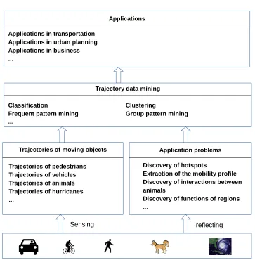
Figure 1: General framework of application-driven trajectory data mining.
questions come to our mind regarding, for instance, the characteristics of these people or the geographical space where they move. By mining these trajectories we may discover places where many people stop frequently and stay for a considerable long duration. These places are characterized as hotspots and the knowledge about hotspots can be used, for instance, in business for advertisement, in public security for crowd monitoring, and in transportation for taxi pick-up point recommendation. Therefore, hotspots discovery is an application problem of which the solution can have various applications.
The core task at the mining step is the application of a specific mining method. This is preceded by a trajectory data pre-processing step, which prepares the data for mining. This step includes tasks such as data cleaning, trajectory compression, map matching, and trajectory segmentation. Data cleaning aims at filtering noise from the data while trajec-tory compression aims at reducing the amount of trajectrajec-tory sample points to reduce the volume of data to be processed. Map matching aims at adjusting trajectory sample points to the roads in case the movement follows a road network while trajectory segmentation
divides a trajectory into meaningful sub-trajectories required for subsequent operations. A discussion of trajectory pre-processing tasks can be found in [150].
3
Trajectory mining methods
Similar to the general domain of data mining, trajectory data mining aims at discovering in-teresting knowledge (e.g., patterns) from the data and it has two primary goals: prediction and description. Prediction consists in using some variables in the data to determine un-known or future values of other variables of interest, while description focuses on finding human-interpretable structures describing the data. We do not try to discuss all existing mining methods; instead we review generic ones and identify the relationships between them. By generic mining methods we mean mining methods applied on a wide range of trajectory data in a wide range of applications. We divide the methods discussed into two categories: primary methods and secondary methods. Given a trajectory dataset, primary methods aim at categorizing the trajectories based on their properties. On the other hand, secondary mining methods are composite methods in the sense that they apply a sequence of primary mining methods or classical statistical methods or a combination of the two.
The discussion of the methods focuses on the objective of the method, its general work-ing principle and the data granularity level at which it works (whole trajectories versus sub-trajectories, single trajectory versus multiple sub-trajectories, and trajectories of single moving object versus trajectories of multiple objects). The discussion ends with an attempt to iden-tify relationships between different methods.
3.1
Primary mining methods
Primary trajectory mining methods are used to categorize the trajectories based on their properties. The application of a primary mining method followed by the interpretation of its results may be the sole intended analysis or the primary mining method may be used to prepare the data for an extended analysis possibly with other mining methods. Primary trajectory mining methods include trajectory clustering and trajectory classification.
3.1.1 Clustering
Trajectory data clustering aims at describing a trajectory dataset by grouping the trajecto-ries into a finite set of categotrajecto-ries, also called clusters, based on their movement character-istics. The trajectories in the same cluster exhibit movement characteristics that are similar and different from those of trajectories in other clusters.
There have been efforts to develop trajectory-specific clustering approaches mainly by adapting statistical and probabilistic models to account for the characteristics of trajecto-ries. For example, the mixture models based clustering approach proposed by Gaffney and Smyth [42] groups together trajectories that are likely to be generated by a common representative trajectory by adding Gaussian noise. In the same line, Alon et al. [2] model trajectories as sequences of transitions between positions and use a hidden Markov model (HMM) that best fits the trajectories to model a cluster.
66 MAZIMPAKA, TIMPF
can be found in [57]. Depending on the goal of analysis some similarity (or distance) func-tion such as similar route, similar destinafunc-tion, similar source, similar route and destinafunc-tion, or similar direction is used to determine which trajectories belong to the same cluster. A de-tailed discussion of how distance and similarity functions are applied to determine cluster membership can be found in Rokach [119].
Among the algorithms that have been extended, two well-known can be mentioned: DBSCAN (density based spatial clustering of applications with noise) [36] and OPTICS (ordering points to identify the clustering structure) [6]. As examples of such extensions, T-OPTICS [106] was developed as an extension of OPTICS by defining a spatio-temporal distance for comparing and clustering trajectories while ST-DBSCAN (spatial-temporal DB-SCAN) [14] uses two parameters for similarity measure to improve the identification of clusters and noise.
Several clustering algorithms have been developed and categorized in different ways (e.g., see in [40, 57, 58]) based on different features but a crisp boundary between the cat-egories is difficult to draw. Most of the categorization approaches identify partitioning, hierarchical, and density-based algorithms. Partitioning algorithms group all objects into a pre-specified number of clusters. These algorithms start from a random partitioning which is then refined through iterations that may move an object from one cluster to another. K-means [94] is an example of such algorithms. Hierarchical algorithms organize the objects in a multilevel structure of clusters and sub-clusters. Using loose proximity requirements, the algorithms find clusters at a higher level while by tightening the proximity require-ments they find sub-clusters. An example of such an algorithm is the BIRCH (balanced iterative reducing and clustering using hierarchies) [147]. Density-based algorithms parti-tion the objects into clusters based on their density, i.e., starting from one object, the cluster grows as long as new objects exist in the neighborhood, and the cluster is considered valid if its total number of objects exceeds a threshold. DBSCAN is an example of algorithm in this category.
Trajectory clustering works on a set of trajectories taking each trajectory in turn and assigning it to a cluster. However, there are some cases in which the input to the clustering operation is not a set of trajectories but only one trajectory. In these cases, the objective is to cluster the points of the single trajectory with the aim of characterizing some positions on it. This case is exemplified in Palma et al. [109] where the points on the input trajectory are clustered to discover stops on it.
Trajectory clustering can be applied on either whole trajectories or sections of trajecto-ries depending on the goal of analysis and the similarity function applied. For example, if the similarity function is defined as similar origin and similar destination, the trajectories can be clustered as a whole because the route followed is not important. An example of this case can be seen in [43] where the interest is on the overall directions of extra-tropical cyclone trajectories for obtaining clusters such assouth-to-north orientedandwest-to-east ori-ented. On the other hand, if the interest is on different locations traversed by the trajectories, for example the similarity is defined as having visited the same types of places; the cluster-ing is applied on sections of trajectories. The TraClus clustercluster-ing algorithm [79] follows this approach.
3.1.2 Classification
The objective of classification is to find a rule to assign objects into pre-defined classes. The knowledge about class assignment is available in the form of a set of predefined classes and a sample set of objects already labeled with the class they belong to. This sample is called a training set. Similar to classification in general, trajectory classification aims at de-termining the class label of trajectories from a predefined set of labels based on the features of the trajectories. For example, the trajectory classification may be aimed at labeling each trajectory from a large set with its transportation mode, given a small set of trajectories manually labeled with the transportation mode used.
Most trajectory classification algorithms follow a traditional two-step approach: first extracting a set of discriminative features and then using the extracted features to train an existing standard classification model. The first step involves identifying the properties of the trajectories that are likely best for identifying the class to which each trajectory belongs, and determining the values of the properties which are then represented in a specific form (e.g., a vector). For example, properties such as the average speed of the trajectory, average acceleration, trajectory duration, and length can be used. The discriminative power of the considered feature depends on the types of classes at hand. For example, we may consider that the acceleration has a much higher discriminative power than the trajectory length for the vehicle type classes. The second step selects a standard classification model and applies it to the extracted features.
A detailed discussion of the traditional classification algorithms can be found in [57]. Among these methods, the following have been commonly applied in trajectory classifica-tion. The decision tree algorithm has been used by Zheng et al. [152] to classify trajectories into different transportation modes. They first segment the trajectories and extract discrim-inative features such as average velocity of a segment, heading change rate, and velocity change rate, which are then fed into a decision tree based inference model for classification. Support vector machines (SVMs) were used by Bolbol et al. [15] to solve the same issue of transportation mode classification. Through a statistical evaluation, they first analyze the discriminative power of four features (speed, acceleration, distance, and rate of change in heading) on six transportation modes (bus, car, cycle, train, underground, and walk). Af-ter identifying the speed and acceleration as the best discriminative features, they applied the SVM algorithm on these features to study equal-sized instances of several segments of trajectories for classifying them.
In many of its applications, trajectory classification is performed after other analysis operations such as segmentation and clustering which prepare the features on which the classification will be based. For example, the TraClass framework [78] applies trajectory segmentation and clustering to extract region and sub-trajectory features that are then used for a support vector machine (SVM) based classification of the trajectories.
3.2
Secondary mining methods
68 MAZIMPAKA, TIMPF
3.2.1 Pattern mining
Trajectory pattern mining aims at discovering and describing the movement patterns hid-den in trajectories. It provides information about when and where the pattern occurs, and the entities involved in it. A large number of types of movement patterns have been re-ported in the literature. An integrated view of them can be found in the survey done by Dodge et al. [35]. Likewise, several methods have been developed for mining these pat-terns. The methods can be put into three categories: repetitive pattern mining, frequent pattern mining, and group pattern mining.
Repetitive pattern mining applies basically on trajectories of a single moving object while frequent pattern mining applies on trajectories of multiple moving objects but in a relative time; that is, the objects may not move at the same time and the only condition is that they visit approximately the same places in the same sequence. Similar to frequent pattern mining, group pattern mining applies to trajectories of multiple objects but the movement is considered in an absolute time; that is, the objects move together.
Repetitive pattern miningconcerns regular movement patterns such as the movement of a commuter, which is repeated every day, or the movement of a migratory bird, which is repeated every season. A repetitive pattern is also called a periodic pattern because the object follows approximately the same route after an approximately constant time period. The discovery of periodic patterns is complicated by the approximate nature of the pat-terns in terms of space and time; i.e., the object does not visit exactly the same location at corresponding time instants of the period and the period does not exactly have the same value in different cycles.
A common approach in discovering periodic movement patterns is to apply the min-ing on sequences of locations. In an earlier study, Cao et al. [20] required the period to be specified as input and clustered the locations corresponding to the same offset of the period to discover frequent regions. They then iteratively combined discovered frequent regions to get complete periodic patterns. The work presented by Cao et al. [20] extended the approach presented in a previous study [97], but both studies required the period as a user input to the mining process. ThePeriodicaalgorithm [85] overcame this undesirable requirement to specify the period in advance. This algorithm first detects automatically the period using an approach combining Fourier transformation and autocorrelation. The algorithm finds reference spots, which are dense regions containing more trajectory points than others, and detects the different periods in each. The algorithm then discovers pe-riodic patterns from movement sequences between reference spots with the same period using a hierarchical clustering for which the distance measure is based on a probabilis-tic model. Compared to most of previous related work, thePeriodicaalgorithm presents two features that address the unknown and varying period issue commonly found on real life movement data: automatic period detection and the consideration of different periods during the periodic pattern discovery.
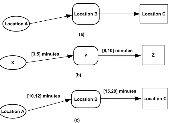
Frequent pattern miningis about extracting (parts of) routes that have been frequently followed by the moving objects in the trajectory dataset. Frequent trajectory patterns can be defined using spatial or spatiotemporal characteristics of the trajectories [68]. The def-inition based on spatial characteristics considers only the sequence of the locations vis-ited. Thefrequent spatiotemporal sequential patterns[19] and thegeneralized sequential patterns
(GSP) [108] are examples of this case. The definition based on spatiotemporal characteris-tics considers, in addition to the sequence of the locations visited, the transition time be-tween the locations. TheT-Patterns(or simplytrajectory patterns) [49] are an example of this
Figure 2: (a) A spatiotemporal sequential pattern, (b) a temporally annotated sequence (TAS), and (c) a T-pattern.
second case. Giannotti et al. [49] defined a T-pattern as “a set of individual trajectories that share the property of visiting the same sequence of places with similar travel times.”. T-patterns evolved from thetemporally annotated sequencesorTASintroduced by Giannotti et al. [47]. In TAS, the elements of a sequence are generic events, e.g., purchases or logged web accesses, without any specific spatial information. Figure 2 shows three types of sequences that make different frequent patterns: for spatiotemporal sequential patterns (a) only the sequence of locations is considered while for T-patterns (c) the transition time between locations (e.g., from location A to location B it takes between 10 and 12 minutes) is also considered. T-patterns (c) combine the feature of location sequence from spatiotemporal sequential patterns (a) with the feature of transition time from TAS (b).
A common approach to mining frequent patterns consists in finding important regions from the trajectories and then applying sequence mining on a temporally annotated se-quence of these regions [49, 65]. In this line, Giannotti et al. [49] developed two approaches for extracting T-patterns. The first approach involves a discretization of the space to iden-tify the regions of interest. Then, the actual mining step applies the method introduced in Giannotti et al. [47] to mine sequences of regions of interest with temporal annotations. The second approach dynamically derives the regions of interest from trajectory segments and then translates the trajectories into a set of sequences of regions from which it iteratively builds T-patterns.
70 MAZIMPAKA, TIMPF
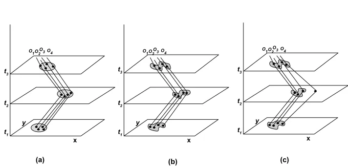
Figure 3: Examples of group pattern: (a) Flock, (b) Convoy, and (c) swarm.
A flock is a group of at least mobjects that travel together for at leastkconsecutive timestamps such that at any of these timestamps they are found within a disc of radiusr. The pattern is defined by the three parametersm,r, andk.
The convoy pattern relaxes the disc shape constraint to represent a group of moving objects forming any shape. It is a group of at leastmobjects traveling together for at least
kconsecutive timestamps such that at each of these timestamps the group can be found using a density-based clustering with parametersdas the neighborhood distance andmas the minimum number of objects.
The swarm pattern is an extension of the convoy pattern, which further relaxes the constraint of consecutive timestamps. It is defined by the same parameters as the convoy except that in a swarmkis the minimum number of timestamps at which the group is found irrespective of whether the timestamps are consecutive or not. For example, withm=4and
k=2the pattern in Figure 3 (c) is not a convoy because only three objects (O1,O2, andO3)
are found in the group for at least two consecutive timestamps. However, this pattern is a swarm because at two timestamps (t1andt3) the group includes the required minimum of
four objects and the swarm pattern does not require the timestamps to be consecutive. The category of group patterns also includes patterns in which the members of the group have some interaction in which each member has a specific role. An example of such pattern is theleadershippattern [4] in which the group comprises a leader which moves ahead and followers for the time duration of the pattern. Another example is thechasing
pattern [31] in which the object moving ahead aims at escaping the follower, which tries to reach it. Different examples of group patterns can be found in [76] under the general concept of relative motion (REMO).
Common approaches to group pattern mining involve clustering methods and checking the condition on parameters that define the pattern such as the minimum number of group members and the minimum duration of the pattern. For example, density-based clustering has been applied in [129] to mine flocks, in [62,63] to mine convoys, and in [86,139] to mine swarms. For swarms, the analysis starts by applying a clustering method at the level of a single timestamp, and then links spatial clusters belonging to different timestamps but sharing an appropriate fraction of objects regardless of their temporal distance.
3.2.2 Outlier detection
The objective in trajectory outlier detection is to find trajectories that do not comply with the general behavior of the trajectory dataset. While pattern mining focuses on patterns that are common in the trajectory dataset, outlier detection focuses on rare patterns (e.g., following a path different from the common path followed by most of the other trajecto-ries).
Similar to trajectory classification, trajectory outlier detection can be performed by min-ing either whole trajectories or parts of trajectories. The work presented in [146] is an exam-ple of outlier detection applied on whole trajectories, while examexam-ples of outlier detection applied on sub-trajectories are found in [77, 88, 140]. For outlier detection applied on parts of trajectories, each trajectory is first segmented into sub-trajectories and then some dis-tance function or clustering method is used to detect outlying sub-trajectories. Finally, the trajectories to which the detected outlying sub-trajectories belong are identified as outliers. This approach has been followed in the TRAOD algorithm [77].
Outliers often appear as a by-product of other mining methods especially clustering. Because of this, most outlier detection approaches in the literature adopt some clustering algorithm and identify as outliers those objects that are not found in any cluster. Hence, the main issue is finding the appropriate distance measure that will discriminate these deviating trajectories.
A basic approach for detecting trajectory outliers analyzes the neighborhood of each trajectory by counting the number of neighbors or using a density-based clustering method. In this approach, the trajectories that have too few neighbors are categorized as outliers. The iBAT [146] anomaly detection framework follows an extended variant of this approach. In iBAT, the study area is partitioned into a grid structure and the trajectories crossing the same source-destination cell-pair are grouped. Finally, the approach uses an isolation mechanism to identify outlying trajectories exploiting the property that they arefew and differentin their groups.
Another category of approaches to trajectory outlier detection follow the procedures used in classification methods. For instance, a set of predefined features can be extracted from the trajectories, and then a standard distance measure applied on the extracted vec-tors. This approach was followed in [140] where distance measures have been applied on four features (direction, speed, angle, and location) to discover trajectory outliers. Alter-natively, trajectory outliers can be discovered by training a two-label classifier model in which one label corresponds to normal trajectories while the other corresponds to abnor-mal trajectories according to the features under consideration. This approach was followed in [82].
3.2.3 Prediction
72 MAZIMPAKA, TIMPF
The studies on location prediction are based on two approaches (Markov models and sequential rules or Trajectory patterns) and can be classified into three categories: i) those considering only the data of the concerned moving object [50, 61, 71], ii) those considering only the data of other moving objects [9], and iii) hybrid approaches; i.e., considering both the data of the concerned object and those of other objects [104, 105, 137]. Studies based on Markov models use probabilistic models for location prediction. Examples of work following this approach can be found in [7, 98]. Studies based on trajectory patterns mine frequent patterns and association rules by defining a trajectory as an ordered sequence of time-stamped locations, and then using sequence mining methods. Examples of work fol-lowing this approach can be found in [104,136,137]. The WhereNext approach [104] extracts T-patterns and builds a decision tree in which root-to-node paths are used for prediction. Ying et al. [136] use a similar approach extracting trajectory patterns to capture the move-ment behaviors that are motivated by geographic, temporal and semantic intentions from trajectories of users, and then matching the current movement of a user to the extracted patterns.
Unlike location prediction, which results in a location, the route prediction must pro-duce a sequence of route segments to a location. The common approaches to route predic-tion fall in the following three categories:
• Trip observations: The approach involves observing several trips from a driver. For a new trip, the approach considers the start point and possibly a short starting section of the new trip, attempts to find a good match with a previous trip, and then uses the matched trip as a route prediction [41].
• Markov model: The approach builds a probabilistic model from the long-term trip history of the driver for predicting short-term route. The model looks at the driver’s just-driven path and predicts the next road segment [69].
• Turn proportions: The approach builds a route by predicting which ways a driver will turn at successive intersections. For instance, Krumm [70] combines the information on which proportion of drivers will choose each turn option at an intersection and the driving times between pairs of road segments to make the turn prediction. This approach is based on the assumptions that drivers tend to choose the road that will give them more destination options and that they take the most efficient route in terms of time to their destination.
3.3
Relationships between trajectory mining methods
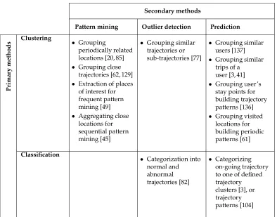
In this section we present the relationships between the different mining methods we have discussed. Table 1 presents these relationships showing primary methods and secondary methods as headings of rows and columns respectively. The secondary mining method at the top of a column uses the primary mining method on the left of a row to perform the task found in their intersection cell. For instance, the outlier detection method may apply clustering to group similar trajectories or sub-trajectories, which may be a required step for detecting trajectory outliers. In addition, an example of this relationship may be found in the reference entry [77]. The empty table cell means that we have not seen in the literature where pattern mining uses classification.
Secondary methods
Pattern mining Outlier detection Prediction
Pr im ar y m et hods Clustering • Grouping periodically related locations [20, 85] • Grouping close
trajectories [62, 129] • Extraction of places
of interest for frequent pattern mining [49] • Aggregating close
locations for sequential pattern mining [45]
• Grouping similar trajectories or sub-trajectories [77]
• Grouping similar users [137] • Grouping similar
trips of a user [3, 41] • Grouping user’s
stay points for building trajectory patterns [136] • Grouping visited
locations for building periodic patterns [61]
Classification
• Categorization into normal and abnormal trajectories [82]
• Categorizing on-going trajectory to one of defined trajectory clusters [3], or trajectory patterns [104]
Table 1: Relationships between trajectory mining methods.
4
Trajectory mining application problems
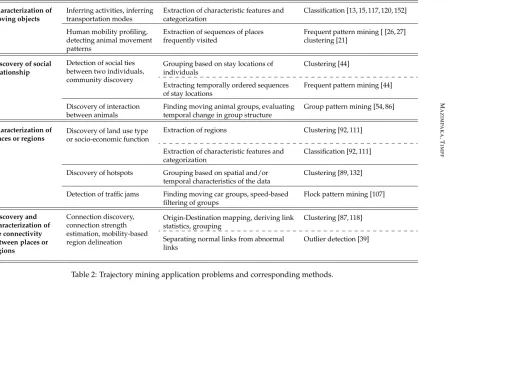
In this section, we discuss different application problems that have been or can be solved by mining trajectories. We categorize the application problems and relate them to generic trajectory mining methods discussed in previous sections. It is important to note that there is no one-to-one mapping between the methods and application problems. Different ap-plication problems may be addressed using the same method and one apap-plication problem may use more than one method; it depends on the specific tasks involved in addressing the application problem as shown in Table 2. The table relates application problems to the methods discussed in previous sections and provides references on where the application problem has been addressed using the methods mentioned.
4.1
Characterization of moving objects
determin-74 M AZI M P AKA ,T IM PF Application problems Application problem instances
Main tasks Mining methods
Characterization of moving objects
Inferring activities, inferring transportation modes
Extraction of characteristic features and categorization
Classification [13, 15, 117, 120, 152]
Human mobility profiling, detecting animal movement patterns
Extraction of sequences of places frequently visited
Frequent pattern mining [ [26, 27] clustering [21]
Discovery of social relationship
Detection of social ties between two individuals, community discovery
Grouping based on stay locations of individuals
Clustering [44]
Extracting temporally ordered sequences of stay locations
Frequent pattern mining [44]
Discovery of interaction between animals
Finding moving animal groups, evaluating temporal change in group structure
Group pattern mining [54, 86]
Characterization of places or regions
Discovery of land use type or socio-economic function
Extraction of regions Clustering [92, 111]
Extraction of characteristic features and categorization
Classification [92, 111]
Discovery of hotspots Grouping based on spatial and/or temporal characteristics of the data
Clustering [89, 132]
Detection of traffic jams Finding moving car groups, speed-based filtering of groups
Flock pattern mining [107]
Discovery and characterization of the connectivity between places or regions
Connection discovery, connection strength estimation, mobility-based region delineation
Origin-Destination mapping, deriving link statistics, grouping
Clustering [87, 118]
Separating normal links from abnormal links
Outlier detection [39]
Table 2: Trajectory mining application problems and corresponding methods.
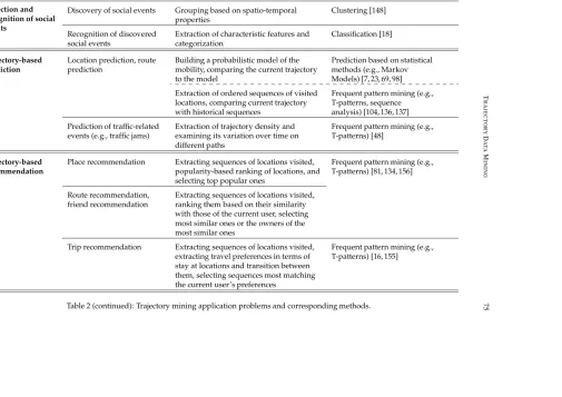
T RAJ E CT OR Y D AT A M IN IN G 75 Detection and recognition of social events
Discovery of social events Grouping based on spatio-temporal properties
Clustering [148]
Recognition of discovered social events
Extraction of characteristic features and categorization
Classification [18]
Trajectory-based prediction
Location prediction, route prediction
Building a probabilistic model of the mobility, comparing the current trajectory to the model
Prediction based on statistical methods (e.g., Markov Models) [7, 23, 69, 98]
Extraction of ordered sequences of visited locations, comparing current trajectory with historical sequences
Frequent pattern mining (e.g., T-patterns, sequence
analysis) [104, 136, 137]
Prediction of traffic-related events (e.g., traffic jams)
Extraction of trajectory density and examining its variation over time on different paths
Frequent pattern mining (e.g., T-patterns) [48]
Trajectory-based recommendation
Place recommendation Extracting sequences of locations visited, popularity-based ranking of locations, and selecting top popular ones
Frequent pattern mining (e.g., T-patterns) [81, 134, 156]
Route recommendation, friend recommendation
Extracting sequences of locations visited, ranking them based on their similarity with those of the current user, selecting most similar ones or the owners of the most similar ones
Trip recommendation Extracting sequences of locations visited, extracting travel preferences in terms of stay at locations and transition between them, selecting sequences most matching the current user’s preferences
Frequent pattern mining (e.g., T-patterns) [16, 155]
Table 2 (continued): Trajectory mining application problems and corresponding methods.
76 MAZIMPAKA, TIMPF
ing the mobility profile such as human mobility routine [26, 27] and animal movement patterns [21, 30, 86], and inferring transportation modes [15, 152].
There has been a high interest in understanding the behavior of individuals byinferring the activitiesthey performed or thetransportation modethey used during their movements. Researchers have addressed this characterization problem instance commonly using classi-fication methods. Another common application problem in the direction of understanding human behavior isdetermining human mobility profiles. A common approach to this prob-lem applies frequent sequential pattern mining to extract the sequences of places that the user frequently visits. A similar problem of understanding the mobility pattern has been studied on animals. A common approach todetecting animal movement patternuses various movement pattern analysis methods especially methods based on clustering. For example, Carneiro et al. [21] applied different clustering methods to study the migration habits of white storks. In particular, they detected flocks by using fuzzy c-means clustering tech-nique.
4.2
Discovery of social relationships
An aim is frequently to analyze the trajectories of moving objects to discover the existence of some interaction between the objects and the properties of this interaction. Instances of this application problem include the detection of social ties between two individuals, community discovery, and the discovery of interaction between animals (e.g., the predator-prey interaction).
The success of online social media platforms in connecting people and encouraging them to share their mobility history has stimulated researchers to study social relation-ships from mobility data. Some researchers addressed the problem of discovering social relationships based on co-presence [28], others based on visits to same places [44, 131]. Co-presence, defined as being in the same place at the same time, has been studied by Crandall et al. [28]. Using a probabilistic model, they found that when two people exhibit multi-ple co-presences, it strongly indicates the existence of a social tie between them. Wang et al. [131] used a probabilistic model to study the similarity in mobility patterns of two individuals and its correlation with their social ties.
A community is a group of entities that share some common interests. In the context of this paper, the common interests are shown by the existence of interaction between the entities, which is in turn detected from their mobility behavior. A common approach to community discovery applies clustering methods. For instance, considering that the stay-locations of individuals during their movement correspond to their interest, Gaito et al. [44] extracted thegeo-locationsas clusters of the stay-locations of individuals and then performed a density-based clustering of the overlapping geo-locations to discover the com-munities. They further detected interactions between communities using a sequential pat-tern analysis.
4.3
Characterization of places or regions
Characterization of places or regions aims to analyze the trajectories of moving objects that visit places and regions under study to derive some structure or information that describes these places and regions. This application problem has been studied under many instances
such as discovery of the semantics of regions in the form of socio-economic functions, the discovery of city hotspots, and the discovery of habitats of particular animals in ecology.
Thediscovery of land use types or socio-economic functionsin a city is commonly performed by applying some clustering followed by a classification. Clustering extracts regions, while the classification assigns land use types or functions to the regions. For example, Liu et al. [92] derived urban land use types (commercial, industrial, residential, institutional, and recreational) and the dynamics of urban land use changes by mining taxi trajectory data. They extracted the temporal distributions of both pick-ups and drop-offs in the pixels of the study area and then used the k-means clustering method to classify all pixels in the study area into different classes of traffic source-sink areas. A classification tree method was then used to quantitatively examine the association of traffic source-sink areas with land uses. For the same problem, Pan et al. [111] applied a different clustering method, a modified version of DBSCAN algorithm (iterative DBSCAN), to extract regions based on the characteristics of the data. They then applied four different classification techniques to classify the regions into different social functions (land use types) based on the pick-up and drop-off dynamics. Yuan et al. [141] address the same problem with a different approach, a topic-based model applied on taxi trajectories and points of interest, and go further to esti-mate the functional intensity for each functional regional using a kernel density estimation model. Though this work takes a different approach, it still applies a k-means clustering to aggregate regions with the same function.
Thediscovery of city hotspots, which are regions in a city with high and regular intensity of activity, is commonly performed using clustering methods. Chang et al. [132] define hotspots as areas with a high number of taxi requests. They first filter trajectories to keep those with the same context (weather condition, day of the week, and hour of the day). Then, they apply a clustering on GPS points corresponding to passenger pick-up points. A hotness index is finally calculated based on the property of the clusters and the distance from the taxi to the cluster. Liu et al. [89] define hotspots based on the crowdedness of areas. Similar to other hotspots discovery studies, they use clustering approach. However, considering that taxis used in the study are a biased sample of vehicles and that taxis are highly mobile, they propose a new clustering approach: mobility-based clustering. This ap-proach is based on a crowdedness function, which is computed taking into account the instant speed of the taxis in the area based on the consideration that low speed may be a good indicator of high crowdedness and vice versa.
Thedetection of traffic jamsis another instance of region characterization. The common approach to addressing this problem involves discovering flock patterns, which are then filtered based on the speed to discover areas of slow flock patterns [107].
4.4
Characterization of the connectivity between places or regions
Discovering and characterizing the existence of a connection between places or regions can be based on the trajectories of objects moving between them. Instances of this problem include discovering connected regions, estimating the strength of the connection between regions, and delineating regions based on the connection between locations within them.78 MAZIMPAKA, TIMPF
and connection strength between different locations in a city on different days. To this end, they derived an OD matrix using clustering techniques. As an extension to the discovery of a connection between regions, the interest may be on the discovery of abnormal connec-tions such as unexpected routes between two regions. This problem instance is commonly addressed through outlier detection methods, which identify and distinguish normal con-nections from abnormal ones [39]. Once the abnormal connection is discovered, a further analysis can be performed to identify the cause of abnormality and the location of this cause, which becomes a place characterization problem [110].
Other studies went further, from discovering the connection between locations to de-lineating regions based on human mobility. The common approach in such studies is to first build a network between locations based on human interaction, and then use some community discovery technique to partition the network into regions. The later step com-monly involves clustering methods, which find location groupings with denser interaction between locations in the group than between groups. The work of Rinzivillo et al. [118] is an example addressing this problem instance by building a network representation of human movement from vehicle GPS tracks and then extracting regions using a hierarchical clustering algorithm.
4.5
Detection and recognition of social events
Detection and recognition of social events aims to analyze the trajectories of moving objects in order to detect the existence of a gathering. The analysis may go further to recognizing the type of event. The two common approaches used to address this problem are statistical methods combined with a classification, and clustering-based methods.
Statistical methods are used to discover a high concentration in a specific area and dur-ing a specific time interval of stationary objects that were initially movdur-ing [48]. Once the presence of events is detected, a further analysis can be performed to recognize their types. In this direction, Calabrese et al. [18] analyzed the origins of event attendees from cell-phones mobility data to recognize the types of events. They used a classification on feature vectors representing the distribution of attendees’ origins to determine the type of events.
Clustering-based approaches extend the standard clustering to discover groups of indi-viduals that are not only dense but also of which the shape and location generally do not change and the members can enter and leave at any time provided there are some members who commit to the group for a certain time period. In this direction, Zheng et al. [148] apply a density-based clustering to discover snapshot clusters, which are then analyzed across a number of timestamps in terms of their locations and members to extract valid gathering patterns.
4.6
Trajectory-based prediction
This problem aims at analyzing the trajectories of moving objects to make some prediction, such as the next location of the moving object, its destination, the route it will take, and the occurrence of traffic related events such as traffic jams. The commonly used methods for trajectory-based prediction are based on Markov models [7,69,98] or movement pattern mining [104, 136, 137].
Giannotti et al. [48] predict traffic congestions by predicting future areas of dense traffic. The location of areas with a high density of trajectories is predicted using a tree structure of
T-Patterns, which are patterns capturing a sequence of visited locations and corresponding transition time. The support value at each node of the tree, which is the number of T-patterns having the path from the root to the current node as prefix, makes it possible to quantify the trajectories on different paths which is analyzed over time for prediction. Another approach applied to the prediction of traffic density is based on Markov model. This approach was adopted by Castro et al. [23], who built a prediction model using the probabilities of transition between road segments. In order to predict traffic congestion, they compare the predicted traffic density and the capacity of the road segments, which they determine based on the historical traffic density and speed readings.
4.7
Trajectory-based recommendation
Trajectory-based recommendations are enabled by the similarity between people inferred from their mobility histories. The similarity between people is commonly inferred by de-termining and comparing their mobility profiles. The assumption behind these recom-mendation systems is that people who have the same mobility behavior are likely to share interests and preferences, and hence are potential friends of each other or are likely to visit the same types of places and follow the same types of routes. For a given individual, once similar users are found they can be recommended to him or her as friends. Alternatively, the places that they visited and the routes they used can be recommended to the individual as places to visit and routes to follow, respectively.
The common approach used to address the trajectory-based recommendation problem is to apply a frequent pattern mining to extract and compare sequences of locations vis-ited. In this direction, Li et al. [81] proposed a general architecture for a friend and place recommender system. The architecture comprises three processes: location history repre-sentation, user similarity exploration, and friend and location recommendation. For each user, they perform a hierarchical clustering of stay points to obtain his location history, which is then represented as a hierarchical graph. In the user similarity exploration, they retrieve a sequence of shared graph nodes between two users, and then retrieve a sequence containing such graph nodes from all users’ graphs. The similar sequences represent a movement pattern that other researchers called T-patterns [49], based on which a similar-ity score is calculated for the pair of users. In the friend and place recommendation step, people can be ranked based on their similarity scores with respect to a given user. Then a set of people with relatively high scores can be recommended to the user as potential friends. A further analysis integrating other data such as points of interest (POIs) with the location histories of these friends can be used to recommend places to the user. The same approach was applied in [134] and [156]. Like Li et al. [81], Xiao et al. [134] focus on the first two processes of the proposed architecture but with an added consideration of the semantics of locations; that is, the location histories are represented as sequences of places (locations with semantic meaning such as restaurant, shopping mall, ...) instead of geographic coordinates. The work in [156] presents a complete recommender system built with this architecture.
80 MAZIMPAKA, TIMPF
the route recommendation in that trip recommendation does not specify the route to be followed from one place to the next in the sequence.
Similar to other trajectory-based recommendation problem instances, trip recommen-dation is addressed through frequent pattern mining methods with some customizations to handle user travel preferences in terms of stay at locations and transition between loca-tions. For example, Brilhante et al. [16] model the mobility history of a user as a temporally ordered sequence of POIs he or she visited, each POI being annotated with the start and end time of visit. They then determine the travel preference of each user based on the functional categories of the POIs in his mobility history. Their system finds a personalized itinerary for a person by comparing his preference to the preferences of users taking into account the time budget the person has for the visit. Zheng and Xie [155] distinguished a generic trip recommendation from a personalized one and developed both. A generic trip recommendation proposes to an individual top interesting locations and travel sequences in a given region. On the other hand, a personalized trip recommendation provides an individual with locations and travel sequences matching his travel preferences.
5
Applications
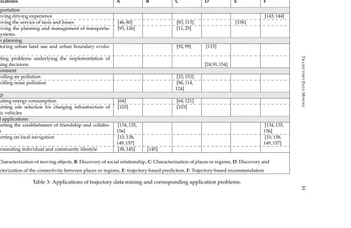
The knowledge generated through trajectory data mining is useful in different application areas. The solution to one application problem can be used in different application fields. For instance, characterizing individuals in terms of their mobility profile can be used in urban planning for the management of recreational facilities [116], in business for planning business promotion activities, and in transportation to organize a car sharing system. Table 3 lists application examples, relating them to the application problems on which they are based, and giving corresponding references in the literature. This section discusses impor-tant requirements in respective application domains and how these requirements translate to application problems for trajectory data mining.
5.1
Transportation
In the transportation sector there is often a need to know the characteristics of regions or places (e.g., to identify major origins and destinations) and the characteristics of moving entities (e.g., when they move in a large number, and where they mainly stop). These two issues translate respectively to the application problems of characterizing regions (mainly hotspots discovery) and characterizing moving objects (mainly determining people’s mo-bility profile). In some cases these problems extend to trajectory-based recommendation and trajectory-based prediction. In this category trajectory data mining aim, for example, at improving driving experience [142–144], the service of taxis and buses [46,80,83,113,158], and the planning and management of transportation systems [11, 25, 93, 126].
5.2
Urban planning
Urban planners traditionally rely on labor-intensive surveys for addressing their concerns to know up-to-date characteristics of different urban regions and to determine the existence and characteristics of an interaction between regions. The first concern translates to region characterization, which is achieved by mining trajectories to identify regional functions or
T
RAJ
E
CT
OR
Y
D
AT
A
M
IN
IN
G
81
Applications A B C D E F
Transportation
Improving driving experience [143, 144]
Improving the service of taxis and buses [46, 80] [83, 113] [158]
Improving the planning and management of transporta-tion systems
[93, 126] [11, 25]
Urban planning
Monitoring urban land use and urban boundary evolu-tion
[92, 99] [115]
Detecting problems underlying the implementation of
planning decisions [24,91,154]
Environment
Controlling air pollution [33, 153]
Controlling noise pollution [96, 114,
124] Energy
Estimating energy consumption [64] [64, 121]
Supporting site selection for charging infrastructure of electric vehicles
[103] [103]
Social applications
Supporting the establishment of friendship and collabo-ration
[134, 135, 156]
[134, 135, 156]
Supporting on local navigation [10, 138,
149, 157]
[10, 138, 149, 157] Understanding individual and community lifestyle [38, 145] [145]
*A: Characterization of moving objects,B: Discovery of social relationship,C: Characterization of places or regions,D: Discovery and
characterization of the connectivity between places or regions,E: trajectory-based prediction,F: Trajectory-based recommendation
Table 3: Applications of trajectory data mining and corresponding application problems.
JO
SIS,
Num
ber
13
(2016),
pp.
82
M
AZI
M
P
AKA
,T
IM
PF
Application problems*
Applications A B C D E F
Business
Improving advertisement strategies [67] [67] [67]
Supporting on choosing a business placement [66] [66] [66]
Improving shopping and selling services [52, 72] [52, 72]
Public security and safety
Detecting misbehavior of individuals [29]
Monitoring big events and crowd behavior [128]
Monitoring phenomena potential to cause natural disas-ters
[17]
Ecology
Supporting the management of free-ranging cattle [8, 59] Understanding of habitat use and supporting effective
an-imal habitat management
[56] [30, 133]
Sports analytics
Game evaluation to support coaching activities
[55,60,123]
*A: Characterization of moving objects,B: Discovery of social relationship,C: Characterization of places or regions,D: Discovery and
characterization of the connectivity between places or regions,E: trajectory-based prediction,F: Trajectory-based recommendation
Table 3 (continued): Applications of trajectory data mining and corresponding application problems
w
w
w
.jo
sis
.o
land use (e.g., [92, 99]). The second concern translates to discovering and characterizing the connectivity between regions. This has been addressed using trajectory data mining for exploring urban boundary evolution [115] and detecting problems underlying a trans-portation network [24, 91, 154].
5.3
Environment
Quantifying the pollution level at different locations and integrating pollution data with other data is important for pollution control. This has been translated to the problem of characterizing places and regions by mining trajectories which are associated with air pol-lution [33,151] or noise polpol-lution [90,96,114,124] measurement values at different locations. In this case, trajectory data mining is a method for increasing the number of sampled loca-tions and integrating and analyzing the data [153].
5.4
Energy
The energy sector is often concerned with determining the energy consumption patterns of specific regions and individuals. These concerns translate to region and moving object characterization, which are addressed by mining trajectories of vehicles [121]. The ap-proach has been followed in implementing eco-driving feedback systems [64, 127], and in site selection for electric vehicle charging infrastructure [103].
5.5
Social applications
Trajectory data mining can support discovering the behavior of individuals and compar-ing them for different types of recommendations. The issues addressed translate to the application problems of determining individuals’ mobility profiles, discovering and char-acterizing their social relationships, and eventually trajectory-based recommendation. For example, the similarity determined from individuals’ mobility profiles [81, 157] enable a recommendation of friends [134, 135, 156], or location and path [10, 138, 149]. Likewise, the activities of individuals inferred from their trajectories enable understanding individual and community lifestyle [38, 145].
5.6
Business
The business sector often needs to determine the visit potential of specific places and the people’s mobility pattern in these places. Trajectory data mining addresses this need by solving the application problems of characterizing places or regions, characterizing moving objects, and trajectory-based recommendation. For example, using trajectory data mining best business location [66,125], best advertisement site [67], and best layout in a store [52,72] have been recommended.
5.7
Public security and safety
84 MAZIMPAKA, TIMPF
with a mass movement, trajectory data mining can contribute to timely detecting or even predicting these threats. The common application problems that need to be solved are characterizing places and moving objects, which can extend to trajectory-based prediction. The approach has been followed for detecting misbehavior [29], monitoring big events and crowd behavior [128], and exploring the movement of hurricanes [34], which can further enable predicting their future occurrence [17].
5.8
Ecology
People managing or doing research on animals are mainly concerned with determining the behavior of individual animals, their interactions, and the habitat use. This work is viewed as solving the application problems of characterizing individual moving objects and discovering and characterizing the interactions between them. For instance, trajec-tory mining has enabled automated detection of activities of animals [8, 56, 59], and their interaction [133], as well as understanding their habitat use [30].
5.9
Sports analytics
The dynamic nature of sports with a lot of movement and events causes a challenge for a timely evaluation. The major concern is to extract and analyze the mobility patterns of a player and his interactions with other players. This can be viewed as the application problems of characterizing moving objects and discovering and characterizing their inter-actions. By mining the trajectories of players, their movement [55, 60] and their interac-tions [123] have been evaluated.
6
Open issues for trajectory data mining
Trajectory data mining has attracted a high research interest and given its applications it is likely to continue attracting this interest. However, trajectory data mining is mainly progressing in the breadth where most of current work concentrates on developing variants of existing methods and applying the method variants to the same application problems. In order to take trajectory data mining to the next higher level there are important open issues that need to be addressed. This section discusses some of the issues.
6.1
Coping with massive data
Most of the data mining methods applied on trajectories were developed in the era of data scarcity and/or in a different domain. Since trajectory data is inherently voluminous and they are increasingly becoming available, future work on trajectory data mining should be scalable to handle massive data. This calls for among others more efficient indexing and aggregation methods that achieve a high data reduction while minimizing information loss.
6.2
Data integration and handling of heterogeneity
Most of the existing studies on trajectory data mining are based on one or one type of dataset (e.g., taxi GPS-based tracks). However, as acknowledged in some papers [92, 99]
such studies face the problem of missing data in some regions or during some periods, which could be resolved by integrating other types of data (e.g., GSM-based trajectories, geo-Social media, etc.). Therefore, future work should look into integrating different types of data by addressing challenges due to their heterogeneity such as reconciling different data formats and different sampling rates.
6.3
Cross-scale trajectory data mining
A trajectory data mining method is commonly developed and demonstrated on one dataset with one specific scale and granularity. However, as demonstrated in [74, 75] the scale and granularity at which the method is applied may affect the result. Therefore, future work on trajectory data mining methods should take into account the scale and granularity to evaluate their impact on the method parameters.
6.4
Mining methods specialists and application domain specialists
While researchers in trajectory data mining methods have been mainly studying the geo-metric trajectory with no consideration of application context, recent collaboration efforts (e.g., the MOVE project [32]) have demonstrated that best results with real life relevance of trajectory data mining can be achieved by a collaboration between method specialists and application domain specialists. Such collaboration facilitates the access to relevant data for methods specialists. It can also support methods specialists in setting suitable values for parameters used in mining methods, a task which is usually left to the method user without guidance.6.5
Privacy handling
While trajectories of animals are easily made openly available, human tracking is asso-ciated with serious privacy issues making high quality human trajectory data hardly ac-cessible to mining method researchers. Despite some work done to address these issues (e.g., anonymization [1, 51]) they prevail. Therefore, future work on trajectory data mining should develop mining frameworks that are more convincing on balancing the extraction of useful knowledge and preserving the privacy of tracked individuals.
7
Conclusion and future work
The increasing use of location-aware devices has led to an increasing availability of tra-jectory data representing the movement of moving objects. The potential of these data in solving important research problems has raised researchers’ interest in analysis meth-ods for them. In particular, inspired by the progress in mining classical large datasets, researchers have developed different data mining methods for trajectories. However, the provision of an integrated view of solved problems and methods in trajectory mining, as well as the applications based on solutions to these problems has not been explored.
86 MAZIMPAKA, TIMPF
the objective in using each method and how it works, the paper identified and discussed relationships that exist between different methods. The paper established a grouping of application problems and related the problems to the mining methods used to address them.
The major contribution of this paper is in providing an integrated view of trajectory mining application problems, the methods used to address them, and the applications that exploit solutions to these problems. The classification of application problems can help researchers in identifying new problems where trajectory mining could be profitably ap-plied. The relationships between the methods and the connection between the application problems and methods can help researchers in identifying method gaps and inspire them to develop new methods. The work presented in this paper can also guide analysts in choosing a suitable mining method for a specific application problem.
The work presented in this paper can be extended by a comparative study of algorithms implementing a specific trajectory mining method on specific application problems with a possibility to provide recommendations on the choice between the algorithms. One of the current trends in movement data analysis is to relate the movement to its embedding context [73]. In view of this trend, our future work will be on customizing algorithms im-plementing some of the presented methods to perform a context-aware mining of trajectory data for selected application problems.
Acknowledgments
The authors would like to acknowledge the financial support from the German Academic Exchange Service (DAAD). They also would like to thank the anonymous reviewers for their comments that helped to improve the paper.
References
[1] ABUL, O., BONCHI, F., AND NANNI, M. Never walk alone: Uncertainty for anonymity in moving objects databases. InProc. 24th International Conference on Data Engineering(2008), IEEE, pp. 376–385. doi:10.1109/icde.2008.4497446.
[2] ALON, J., SCLAROFF, S., KOLLIOS, G.,AND PAVLOVIC, V. Discovering clusters in motion time series data. InProc. IEEE Computer Society Conference on Computer Vision and Pattern Recognition(2003), IEEE, pp. 375–381. doi:10.1109/cvpr.2003.1211378. [3] ANAGNOSTOPOULOS, T., ANAGNOSTOPOULOS, C., AND HADJIEFTHYMIADES, S.
An online adaptive model for location prediction. Autonomic Computing and Commu-nications Systems 23(2010), 64–78. doi:10.1007/978-3-642-11482-3_5.
[4] ANDERSSON, M., GUDMUNDSSON, J., LAUBE, P.,ANDWOLLE, T. Reporting leaders and followers among trajectories of moving point objects.Geoinformatica 12, 4 (2008), 497–528. doi:10.1007/s10707-007-0037-9.
[5] ANDRIENKO, G., ANDRIENKO, N., BAK, P., KEIM, D., KISILEVICH, S., AND WROBEL, S. A conceptual framework and taxonomy of techniques for analyz-ing movement. Journal of Visual Languages and Computing 22, 3 (2011), 213–232. doi:10.1016/j.jvlc.2011.02.003.
[6] ANKERST, M., BREUNIG, M. M., KRIEGEL, H.-P., AND SANDER, J. OPTICS: Ordering points to identify the clustering structure. In Proc. ACM SIGMOD International Conference on Management of Data (1999), ACM Press, pp. 49–60. doi:10.1145/304182.304187.
[7] ASAHARA, A., MARUYAMA, K., SATO, A., AND SETO, K. Pedestrian-movement prediction based on mixed markov-chain model. In Proc. 19th ACM SIGSPATIAL International Conference on Advances in Geographic Information Systems (2011), ACM Press, pp. 25–33. doi:10.1145/2093973.2093979.
[8] AUGUSTINE, D. J., AND DERNER, J. D. Assessing herbivore foraging behav-ior with GPS collars in a semiarid grassland. Sensors 13, 3 (2013), 3711–3723. doi:10.3390/s130303711.
[9] BACKSTROM, L., SUN, E., AND MARLOW, C. Find me if you can: Improv-ing geographical prediction with social and spatial proximity. In Proc. 19th International Conference on World Wide Web (2010), ACM Press, pp. 61–70. doi:10.1145/1772690.1772698.
[10] BAO, J., ZHENG, Y.,ANDMOKBEL, M. F. Location-based and preference-aware rec-ommendation using sparse geo-social networking data. InProc. 20th ACM SIGSPA-TIAL Conference on Advances in Geographic Information Systems (2012), ACM press, pp. 199–208. doi:10.1145/2424321.2424348.
[11] BASTANI, F., HUANG, Y., XIE, X., AND POWELL, J. W. A greener transportation mode: Flexible routes discovery from GPS trajectory data. InProc. 19th ACM SIGSPA-TIAL International Conference on Advances in Geographic Information Systems (2011), ACM Press, pp. 405–408. doi:10.1145/2093973.2094034.
[12] BENKERT, M., GUDMUNDSSON, J., HÜBNER, F., AND WOLLE, T. Re-porting flock patterns. Computational Geometry 41, 3 (2008), 111–125. doi:10.1016/j.comgeo.2007.10.003.
[13] BILJECKI, F., LEDOUX, H.,ANDOOSTEROM, P. V. Transportation mode-based seg-mentation and classification of movement trajectories. International Journal of Geo-graphical Information Science 27, 2 (2013), 385–407. doi:10.1080/13658816.2012.692791. [14] BIRANT, D., AND KUT, A. ST-DBSCAN: An algorithm for clustering spatial-temporal data. Data and Knowledge Engineering 60, 1 (2007), 208–221. doi:10.1016/j.datak.2006.01.013.
[15] BOLBOL, A., CHENG, T., TSAPAKIS, I., AND HAWORTH, J. Inferring hy-brid transportation modes from sparse GPS data using a moving window SVM classification. Computers, Environment and Urban Systems 31, 6 (2012), 526–537. doi:10.1016/j.compenvurbsys.2012.06.001.
88 MAZIMPAKA, TIMPF
[17] BUCHIN, M., DODGE, S.,ANDSPECKMANN, B. Similarity of trajectories taking into account geographic context. Journal of Spatial Information Science 9(2014), 101–124. doi:10.5311/josis.2014.9.179.
[18] CALABRESE, F., PEREIRA, F. C., LORENZO, G. D., LIU, L.,ANDRATTI, C. The geog-raphy of taste: Analyzing cell-phone mobility and social events. InPervasive: Proc. 8th International Conference on Pervasive Computing(2010), Spri