INTEGRATED WATER RESOURCES
MANAGEMENT
LAND USE DYNAMICS AND BIODIVERSITY
ENERGY EFFICIENCY AND RENEWABLE
RESOURCES
REGIONAL MANAGEMENT AND
SUSTAINABLE LIVELIHOODS OF THE POOR
ISSN 0719-2452
VOLUME 3 - 2013
DOI: 10.5027/jnrd.v3i0.01 - DOI: 10.5027/jnrd.v3i0.13
Site suitability analysis for Bay scallop aquaculture and implications for sustainable fisheries management in the Ha Long Bay
archipelago, northern Vietnam. 1
Authors: Marconi Michele, Pham Thuoc, Nguyen Tien Canh, Pham Thi Khanh, Marincioni Fausto DOI: 10.5027/jnrd.v3i0.01
Hydromorphological assessment as a tool for river basin management: The German field survey method 14 Authors: Georg Meir, Thomas Zumbroich, Jackson Roehrig.
DOI: 10.5027/jnrd.v3i0.02
Purification and characterization of toxic waste in the aquatic environment using common carp, Cyprinus carpio 27 Authors: Hanan Abd Al-Gawad, Enas M. Ramzy
DOI: 10.5027/jnrd.v3i0.03
Community perception on climate change and climate-related disaster preparedness in Kathmandu Valley, Nepal 35 Authors: Udo Nehren, Jishnu Subedi, Ina Yanakieva, Simone Sandholz, Jibraj Pokharel, Ajay Chandra Lal, Inu Pradhan-Salike, Muh Aris Marfai, Danang Sri Hadmoko, Günther Straub
DOI: 10.5027/jnrd.v3i0.04
A water productive and economically profitable paddy rice production method to adapt water scarcity in the Vu Gia-Thu Bon
river basin, Vietnam 58
Authors: Bhone Nay-Htoon, Nguyen Tung Phong, Sabine Schlüter, Aldas Janaiah DOI: 10.5027/jnrd.v3i0.05
Natural resources endowment and economic growth: The west african experience 66
Author: Mohamed Jalloh DOI: 10.5027/jnrd.v3i0.06
A proposal for tsunami mitigation by using coastal vegetations: some findings from southern coastal area of Central Java,
Indonesia 85
Author: Djati Mardiatno DOI: 10.5027/jnrd.v3i0.07
Public-private partnership as a responsive culture for green management in Bangladesh: A study of natural resources
management at Lawachhara national park 96
Authors: Mohammad Nashir Uddin, Mohammad Hamiduzzaman DOI: 10.5027/jnrd.v3i0.08
Irrigation management strategies for winter wheat using AquaCrop model 106
Authors: M. H. Ali, I. Abustan, A. B. Puteh DOI: 10.5027/jnrd.v3i0.09
Indigenous perceptions of soil erosion, adaptations and livelihood implications: the case of maize farmers in the Zampe
community of bole in the northern region of Ghana 114
Author: Bukari Francis Issahaku Malongza DOI: 10.5027/jnrd.v3i0.10
New focus of environmental education programs [Commentary] 121
Author: Alexander Neaman DOI: 10.5027/jnrd.v3i0.11
Simulation of upward flux from shallow water-table using UPFLOW model 123
Authors: M. H. Ali, I. Abustan, S. Islam DOI: 10.5027/jnrd.v3i0.12
Evaluation of methods for digital elevation model interpolation of tillage systems 128
Authors: Setiawan M. A., Rutzinger M., Wichmann V., Stoetter J., Sartohadi J. DOI: 10.5027/jnrd.v3i0.13
Journal of Natural Resources and Development 2013; 03: 1-139 Volume III
JOURNAL OF
NATURAL RESOURCES
AND DEVELOPMENT
Site suitability analysis for Bay scallop aquaculture and
implications for sustainable fisheries management in
the Ha Long Bay archipelago, northern Vietnam.
Marconi Michele
a, Pham Thuoc
b, Nguyen Tien Canh
b, Pham Thi Khanh
b, Marincioni Fausto
a, *.
a Department of Life and Environmental Sciences, Marche Polytechnic University , Via Brecce Bianche, 60131 Ancona, Italy
b Research Institute of Marine Fisheries, 224 Le Lai, Hai Phong, Vietnam
* Corresponding author : [email protected], phone: +39 071 2204312; fax: +39 071 2204650.
Article history
Abstract
Received 11.08.2012 Accepted 17.10.2012 Published 07.01.2013
Mollusc culture if properly managed, may help decrease capture fisheries over-exploitation in Vietnam, and possibly become an alternative income for local fishermen. The definition and characterization of zones suitable for aquaculture is pivotal for its success and sustainable development, and this study aims at determining the suitability of Argopecten irradians (Bay scallop) culture in the Ha Long Bay Archipelago. Temperature, salinity, chlorophyll-a, total suspended solid and bathymetry, were compiled in an environmental suitability model. Distance of culture sites from landing points and fish markets were instead grouped in an infrastructural suitability model. In both models, developed with Geographic Information Systems, the suitability scores were ranked on a scale from 1 (unsuitable) to 6 (very-highly suitable). Results showed that 98 % of the studied area is environmentally suitable for such culture. However, overlaying the infrastructural factors the suitable zone decrease to 38 %. Advantages and disadvantages of two management options were then discussed: (a) strengthening fisheries infrastructures or (b) developing post harvesting processing plants.
Argopecten irradians aquaculture Bay scallop
Multi-criteria evaluation Sustainable exploitation Ha Long Bay
Introduction
Molluscs appear to be a key species for the development of aquaculture in the XXI century (Kongkeo 2001), and its production is increasing worldwide, enhancing both seafood yield and the economic-social welfare of coastal communities (Bourne 2000). This is particularly important for countries like Vietnam where traditional capture fisheries appear over-exploited (Pomeroy et al. 2009). As a matter of fact, the Vietnamese government had planned to put in
production 76 thousand hectares by 2010, expecting to harvest 380 thousand tons of mollusc, with an exported value of 760 million of USD (MOFI 2003). Indeed, molluscs’ production in Vietnam has increased from 40 to 170 thousand tons over the period 2000-2008 (FAO 2010); even so yields are still far from the optimistic forecast of the government. The Vietnam Association of Seafood Exporters and Producers asserts that Vietnam’s mollusc exports in 2010 reached 125
Journal of Natural Resources and Development 2013; 03: 01-13
01
Keywords
02
Journal of Natural Resources and Development 2013; 03: 01-13thousand tons, earning 490 million of USD (VASEP 2011).
In Vietnam, as in many other countries, the development of the mollusc aquaculture still face a number of hindrances including limited accessibility to suitable sites (Binh et al. 1997) and the apprehension regarding environmental impacts and multi-use conflicts (Ridler 1998). Inappropriate aquaculture activities may lead to an over-exploitation of the natural resources. To prevent these problems, several programs of stock enhancement have been implemented for various species of aquatic products worldwide (Bell et al. 2006), including an extraordinary success with scallops (Uki 2006). Such programs led to increased production through careful selection of both the aquaculture sites and the natural restocking operations, considered key factors for the success and sustainability of mollusc culture (GESAMP 2001).
Argopecten irradians Lamarck (1819), commonly called Bay scallop (Figure 1), is a cultured molluscs species with high commercial value (Stotz and Gonzales 1997). Native of North American coastal water, Bay scallop was introduced in China in 1982 where it became the dominant cultured species of scallop (Zhang et al. 1986). The species
was transplanted into Vietnam in 2004.
The short life span of Bay scallop (18-22 months) is both strength and weakness. Indeed, farmers benefited from the short culture duration, allowing a rapid financial turnover (Milke et al. 2006), however, because that adult spawn only once in their life, if natural population of Bay scallops has declined, its natural recovery is limited (Goldberg et al. 2000). Therefore, accurate culture site selection is necessary to minimize environmental impact and over-exploitation risks, thus maximizing the overall economic return.
To gather background information necessary to expand Bay scallop culture in Vietnam and to envision possible livelihoods alternatives for the local small scale fisheries, it was necessary to: (i) assess the biological and reproductive characteristics of this mollusc in northern Vietnam, (ii) identify its most suitable farming zones in the Ha Long Bay archipelago, using Analytic Hierarchy Process (AHP) and Geographic Information Systems (GIS), and (iii) evaluate the capacity of such culture to provide an alternative income to fisherman willing to give up capture fisheries.
Figure 1. Argopecten irradians (Lamarck, 1819), commonly called Bay scallop.
Four subsequent research phases can be defined: (a) biological measurements on farmed Argopecten irradians, to determine its sexual maturity’s period in northern Vietnam; (b) environmental and infrastructural data collection of the studied area, (c) hierarchy and spatial analysis to develop the suitability models for Bay scallop aquaculture, and (d) scenarios analysis to increase Bay scallop culture and decrease capture fisheries over-exploitation.
Study area
The sea area chosen for the study lies between 106°50’ to 107°10’ East and 20°40’ to 20°55’ North (Figure 2) and is deep between 6 and 25 meters. It includes the archipelago of Ha Long Bay, with the two inhabited islands of Cat Ba and Cat Hai and the surrounding waters. Ha Long Bay is a inlet near the mouth of the Bach Dang River with a
03
Journal of Natural Resources and Development 2013; 03: 01-13Sampling and measurement of biological parameters
From November 2005 to October 2006, 105 sample of Argopecten irradians were purchased monthly from selected aquaculture operations located in the study area, growing juvenile Bay scallops supplied by the Northern National Broadstock Center (Cat Ba Island). Shell dimensions (length, height and width), body (total and soft tissue) and gonads weights were measured for each individual using a micrometer with accuracy of 0.01 mm and micro scale balance (± 0.01 gram). From these 105 scallops, 80 gonads were randomly chosen and analyzed with electron microscopy (Nikon Eclipse-50i). The gonad condition of each Bay scallop was classified into 5 stages (Chipperfield 1953; Sastry and Blake 1971). The spawning season was determined as the time when over 70 % of the individuals were at stage III (maturing) and IV (mature).
Environmental and infrastructural data collection
The identification and classification of suitable culture sites was carried out combining the key environmental and infrastructural parameters affecting scallops growth and commerce. Sea temperature, salinity, food availability (i.e. chlorophyll-a), suspended sediment and
bathymetry have been documented to be the key environmental factors affecting scallops’ growth (Kingzet et al. 2002; Shriver et al. 2002; Ellis et al. 2002). Similarly, the culture sites’ distance from landing points and fish markets appear to be the pivotal infrastructural factor affecting aquaculture operations (Kingzet et al. 2002).
Average temperature, salinity, chlorophyll-a, total suspended sediment and bathymetry for the months of Bay scallop’s sexual maturity, were collected in map format from the Ministry of Science Technology and Environment of Vietnam during the late 1990s (MOSTE 2000). The location of landing points and fish markets were instead digitized from the topographic map (scale 1:100 000) of Quang Ninh’s and Hai Phong’s provinces. These maps after digitization were overlaid to create the: environmental and infrastructural suitability models of Bay scallop culture in the study area.
Spatial analysis to identify suitable culture sites
The Geographic Information System (GIS) used in this study was Quantum-GIS 1.6.0. The geographical data-sets were projected on a WGS 84 UTM zone 48-North coordinate system.
The environmental factors were subjected to an Analytic Hierarchy Process (AHP) performed though a pair-wise comparison matrix Figure 2. Study area
mature karsts seascape of a multitude of sparsely tree-clad limestone pinnacles rising from the sea. Its waters, due to the thousands of pinnacle islands, are calm and turbid (Tran et al. 2004). The mean tidal excursion ranges between 3 and 4 meters, and the annual rainfall is about 1800-2000 mm (Tang 2001).
The climate is characterized by a relatively dry Northeaster winter monsoon (November/December to May/June) and a wetter
summer monsoon (June/July to October/November) (MOSTE 2000). Environmental condition are stable during the winter-monsoon season, with narrow range of water temperature and salinity, and low river discharge, whereas the summer monsoon season is environmentally unstable, accompanied by large river discharge events, causing large fluctuation of water temperature and salinity.
04
Journal of Natural Resources and Development 2013; 03: 01-13Table 1. Pair-wise comparison matrix incorporating the advices expressed by both, Vietnamese National experts and local aquaculturists, on the relative importance of the main environmental factors affecting Bay scallop aquaculture in Ha Long Bay and Cat Ba island (numbers show the rating of the row factors relative to the column factor); consistency ratio 0.77 %.
Subsequently, an aquaculture suitability scoring system, from 1 to 6 (slightly modified from Pérez et al. 2005), was applied to the geographical data-sets in order to normalize each considered environmental or infrastructural factor. The most suitable zones for Bay scallop culture received a score “6” while not suitable zones received a score “1” (table 2). The formula used to calculate the total suitability score for each location inside the study area, was Malczewski’s (2000): V(xi) = ∑j wj rij, which considered the relative weight and the suitability score of each environmental or infrastructural factor. In such formula,
“wj” represents the relative weight of environmental or infrastructural factor “j”, and “rij” is the score attributed to the factor “j” in the specific location “i”.
The environmental and the infrastructural suitability maps thus obtained, were successively overlaid to compute the final aggregated suitability aquaculture map. The overlay was executed according to three scenarios (table 3), each giving a different importance to the environmental and infrastructural models.
(Saaty 1977). The AHP allowed incorporating the advices expressed by Vietnamese National experts and local farmers, of the relative weights exerted by these environmental factors on Bay scallop
aquaculture (table 1). Distance of culture sites from landing points and fish markets were incorporated to create several buffer zones with different infrastructural suitability.
Salinity Sea temperature Chlorophyll-a Suspended
solid Bathymetry Weight
Salinity 1 13/10 2 8/3 7 0.3579
Sea temperature 10/13 1 4/3 2 5 0.2638
Chlorophyll 1/2 3/4 1 5/3 4 0.1963
Suspended solid 3/8 1/2 3/5 1 2 0.1278
Bathymetry 1/7 1/5 1/4 1/2 1 0.0542
Score Temperature
(°C) Salinity range Chlorophyll-a range (µg l-1) Suspended solid (mg l-1) Bathymetry(m) Infrastructures distance (miles) 1
Not suitable < 5 1-40 1-2 > 55 < 3 > 8
2
Very-lowly
suitable 5-14 10-40 2-5 40-55 3-6 6 – 8
3
Lowly suitable 15-18 13-37 4-5 25-40 6-10 5-6
4
Suitable 18-23 18-34 5-10 15-25 10-13 4-5
5 Highly
suitable and > 28 23-26 23-31 8-15 5-15 13-15 3-4
6
Very-highly
suitable 26-28 25-29 > 13 < 5 > 15 < 3
Table 2. Suitability scores for Bay scallops aquaculture obtained from the normalization of environmental and infrastructural factors. Ranges and scores are modified from: Shriver 2002; FAO 1991, Korol 1985; Kirby-Smith 1970.
05
Journal of Natural Resources and Development 2013; 03: 01-13Scenarios analysis to increase Bay scallop culture and decrease
capture fisheries
Cat Ba and Cat Hai islands (Cat Hai district) are the only two populated islands of the studied archipelago, with roughly 23 thousands inhabitants of which 500 got their main income from capture fishing. An additional 3700 people live on floating villages off the coasts (Tuan 2009). Although there is no certainty about the number of people living on the floating villages that are engaged in capture fisheries, an approximate figure could be obtained considering the 2009 general census of Vietnam. Such census reports that the active (working) individuals in Vietnam amounts at 55 % of the total population (General Statistic Office of Vietnam 2010a). Applying this ratio to the floating village population, we can assume that about 2000 individuals are active, namely involved in capture fisheries. This would project at approximately 2500 the people nowadays engaged in capture fishing activities in Cat Hai district. Such figure is corroborated by the fishing boats registry of the Department of Agriculture and Rural Development of Hai Phong (2009), which counts in the district of Cat Hai about 500 vessels, developing roughly 20 thousands HP. It is also assumed that the Cat Hai fishing fleet has the same capture fishing productivity of the other Vietnamese fishing vessels operating in the larger context of the Tonkin Gulf, which in 2008 reached 0.24 ton HP-1 year-1 (RIMF 2009). Therefore, the capture fishing yield in Cat Hai district can be estimated at about 4800 tons per year, roughly equivalent to a total of 5.5 million of USD per year, or about 2300 USD year-1 per fisherman.
Scientists, policy makers and planners agree on the fact that
Vietnam’s fisheries resources are over-exploited (Pomeroy et al. 2009), yet there are divergences on defining the sustainable level of fishing activities. Several studies assessed the maximum sustainable yield for capture fishery in Vietnam as the one reached in the year 1990 (van Zwieten et al. 2002; Thang 2007), when the capacity of the Vietnamese fishing fleet was about half of nowadays. This estimation implies that to achieve sustainable capture fisheries in the district of Cat Hai, almost half of the local fishermen, circa 1250, should change the main source of their livelihoods. Hence, to assess the possibility of replacing capture fisheries with Bay scallop aquaculture, the potential production of such mollusc was calculated.
The sea surface effectively used in a Bay scallop plant was computed as the product of the cage surface by the number of cages deployed in each hectare, multiplied by the number of hectares used for aquaculture operations. The cage for farming Bay scallops is a tube shaped net, woven with polyethylene threads, separated into eight chambers by plastic disks of 17.5 cm radius. Thus, the total cage surface amounts to 0.769 square meters (the cage’s number of chambers by its area). Considering that the culture cages are hooked one meter apart on a 100 meters long floating lines, and that the spacing between each floating line is eight meters, every hectare contains 13 floating lines. Thus, the total number of cages for each hectare is 1300. Therefore, multiplying 1300 (cages) by 0.769 (total cage surface) we obtain an effective farming surface of 1000 square meters per hectare of sea surface. The study area’s potential production was thus computed multiplying the effective farming surface by the Bay scallop culture productivity values (discussed in : Bay scallop aquaculture production assessment).
Results
Study area environmental setting and circulating seawater
Modeled surface temperature of seawater in the culture zones ranged between 19.7°C and 33.2°C. The lowest average temperature occurred in the winter (from January to March), reaching 21.0°C, gradually increasing to 33.2°C in June and July. Modeled seawater salinity varied from 24.7 to 33.0. It reached values higher than 30.0 from the end of November to May, slowly decreased to intermediate levels during the months of June and July, to markedly drop to values lower than 25.0 from August to October. Modeled seawater concentration of chlorophyll-a, averaged 11.5 µg l-1, ranging from a minimum value of 2 µg l-1, during the dry season (from November to May), to values higher than 15 µg l-1,(from August to October). Overall, chlorophyll-a concentration measured values higher than 13 µg l-1, in two third of the studied area. In terms of suspended solid in the seawater, the modeled concentrations averaged 20 mg l-1, with values ranging from 4 to 25 mg l-1 in the eastern section of the study area, and reaching peaks of 45 mg l-1 in the Red River Delta. Finally, the bathymetric data showed an average depth of the sea bottom at about 10 meters, ranging from about minus 2 to minus 15 meters. The sea bottom topography presents two main morphology types: i) an irregularly eroded limestone platform with emerged pinnacles
and submerged canyons reaching depth of 15 meters, in the eastern section of the study area, and b) the Red River delta, showing a more regular morphology averaging minus 5 meters, in the western part.
Gonads development
Gonads observation at the microscope indicated that Bay scallops were in stage I - II (not mature) from January to June. A small number of gonads entered in stage III as early as July, when their eggs and sperm could be distinguished (in some wet scanned specimens, the sperm was found to slowly move). The majority of sampled Bay scallops showed stage III gonads from mid-July to mid-August. Their gonads showed quick changes in volume and color, acquiring a pale orange color in the ovarian region and a creamy color in the testicular region. By the end of August through the end of October all collected scallops had mature gonads (stage III and IV), and by December most individuals had finished their reproductive cycle showing transparent and soft gonads (stage V). Data, summarized in Figure 3, show that Bay scallop’s spawning season in Ha Long bay and Cat Ba Island started in August and continued throughout November, with the spawning peak between September and October.
06
Journal of Natural Resources and Development 2013; 03: 01 -13Figure 3. Gonads’ development during the year
Site suitability analysis: environmental and infrastructural models
Spatial analysis of the studied environmental and infrastructural factors were performed to: (i) display the areal extension of the six aquaculture suitability scores (shown in table 2) computed for each considered environmental and infrastructural factor (Figure 4), and (ii) to map the areas providing various conditions of growth and survival conditions for Bay scallops (Figure 5 and 6, and table 3). In particular the environmental suitability model showed that: (a) the zone located
in the proximity of the South-East coast of Cat Ba Island, circa 10 % of the total study area, is very-highly suitable (score 6) for growth of Bay scallops, (b) the zone stretching from the South and West coast of Cat Ba Island to the Nam Trieu estuary, roughly half of the study area, is highly suitable (score 5), (c) the Ha Long Bay sea zone, East and North of Cat Ba Island, about 39 % of the study area, is environmentally suitable (score 4), and (d) the inner part of Nam Trieu estuary and the deepest area far away from Cat Ba Island, only 2 % of the study area, is lowly suitable (score 3). This was the lowest environmental suitability score measured in the total study area.
Score Environment Scenario A Scenario B Scenario C Infrastructures
(%)
(Environmental predominance) (%)
(environment tantamount infrastructures) (%)
(Infrastructural predominance)
(%) (%)
Environment 100 65 50 35 0
Infrastructure 0 35 50 65 100
1 Not suitable 0 0 0 0 34
2 Very-lowly
suitable 0 1 9 34 24
3 Lowly suitable 2 37 46 28 12
4 Suitable 39 34 21 17 11
5 Highly suitable 50 20 15 10 8
6 Very-highly
suitable 9 8 9 11 11
Table 3. Percentage of total study area for each suitability score for the environmental and infrastructural models, as well as for the three formulated suitability scenarios for Bay scallop aquaculture in Ha Long Bay and Cat Ba Island.
07
Journal of Natural Resources and Development 2013; 03: 01-13Figure 4. Percentage of total study area for the six suitability scores computed for each one of the environmental and infrastructural factors. CHL-a is chlorophyll-a; TSS is total suspended solid; TEMP is temperature; SALT is salinity; BATHY is bathymetry; INFRA is infrastructure.
08
Journal of Natural Resources and Development 2013; 03: 01-13The spatial analysis for the infrastructural suitability model, using the distance ranges shown in the last column of table 2, showed that in terms of available infrastructures for aquaculture, circa 11 % of the study area (Figure 6 and table 3) is very-highly suitable (score 6), some 8 % highly suitable (score 5), and another 11 % suitable (score 4). These waters surround the urbanized West coast of Cat Ba Island, which contains numerous landing points and fish markets. Conversely, 12 % and 24 % of the total studied area, appeared
respectively lowly (score 3) and very-lowly (score 2) suitable for Bay scallop culture. These are the Northern part of Ha Long Bay and the open water West of Cat Ba Island. Finally, about 34 % of the studied area is too far from both main fish markets or landing points, and rank unsuitable for aquaculture operations (score 1). These are the waters surrounding the rugged and undeveloped North and East coast of Cat Ba Island (Figure 6).
Figure 5. Environmental suitability map for Bay scallop aquaculture in Ha Long Bay and Cat Ba Island. Suitability increases with score value (1 = Not suitable zones; 6 = Very-highly suitable zones).
Figure 6. Infrastructural suitability map for Bay scallop aquaculture in Ha Long Bay and Cat Ba Island. Suitability increases with score value (1 = Not suitable zones; 6 = Very-highly suitable zones).
09
Journal of Natural Resources and Development 2013; 03: 01-13The combination of the different environmental and infrastructural factors (table 3) produced three suitability scenarios. The first one, which give to the environmental factors the greatest relative importance (Figure 7A, table 3), showed that only 8 % of the study area is very-highly suitable (score 6), 20 % ranked highly suitable (score 5), and 34 % suitable (score 4). Conversely, some 37 % of the total surface area ranked lowly suitable (score 3) and 1 % very-lowly suitable (score 2). No zone was identified unsuitable (score 1) for Bay scallop culture.
In scenario B, which attributes the same weight to the environmental and infrastructural models (Figure 7B, table 3), slightly expands to 9 % the very-highly suitable zone (score 6). However, the highly suitable and the suitable zones (scores 5 and 4) decrease sensibly from 54 to 36 %. Not surprisingly, the lowly and very-lowly suitable zones (scores 3 and 2) increase to 55 %. In this scenario too, no zone was identified unsuitable (score 1) for Bay scallop culture.
Finally, in scenario C, which give to the infrastructural factors the greatest relative importance (Figure 7C, table 3), further expands to 11 % the very-highly suitable zone (score 6), yet the sum of the highly suitable and suitable zones (scores 5 and 4) decrease to 27 % of the total study area (circa half of that computed in the first scenario). Also the lowly suitable zone (score 3) decrease to 28 %, but the very-lowly suitable (score 2) sharply increase to 34 %. In the end the sum of the lowly and very-lowly suitable zone of scenario 3 is similar to that of scenario 2. Here too, no zone was identified as unsuitable (score 1) for Bay scallop culture.
The most noticeable differences passing from scenario A to C (Figure 7) in the waters surrounding Cat Ba Island, are between Ha Long Bay (North and East), Cat Gia and Lan Ha Bays (South) and the western coast of Cat Ba and Cat Hai Islands in front of the Red River Delta (Figure 1).
Increasing the importance of infrastructural factors the majority of Ha Long Bay, Cat Gia Bay and Lan Ha Bay waters decrease their aquaculture suitability score, with some zones passing from score 5 (highly suitable) to 2 (very-lowly suitable), whereas the water facing the Red River Delta increase the overall zone with score 6 (very-highly suitable).
Bay scallop aquaculture production assessment
Bay scallop aquaculture may yield between 45 and 52.5 tons hectare-1, if salinity, temperature and suspended solid are optimal, and the carbon content of waters is over 150 µgC l-1 (FAO 1991). In the study area these conditions are met in the highly and very-highly suitable zones for Bay scallop aquaculture, which are characterized by Chlorophyll-a concentration higher than 8 µgChl-a l-1 (table 2). As a matter of fact, considering that tropical coastal areas, are characterized by a carbon/ Chlorophyll-a ratio higher than 20 (Behrenfeld et al. 2005), the carbon concentration of the study area’s highly and very-highly suitable zones is higher than 160 µgC l-1.
As mentioned earlier, a typical Bay scallop farm has an effective farming surface of 1000 square meters per hectare of sea surface, namely a ratio 1/10 between the effectively farmed zone and the total area occupied by the farming plant. Therefore, just the study area’s very-highly suitable zone, which extends for 7325 hectares, could easily yield a minimum 33 thousand tons year-1 of Bay scallop.
Figure 7. Maps of the three formulated suitability scenario for Bay scallop culture in Ha Long Bay and Cat Ba Island. In map (A) the environmental factors were more important than infrastructural ones (65 % and 35 % respectively); in map (B) the environmental and infrastructural factors have the same weight; finally in map (C) the infrastructural factors are more important than environmental one (65 % and 35 % respectively). Suitability increases with score value (1 = Not suitable zones; 6 = Very-highly suitable zones).
10
Journal of Natural Resources and Development 2013; 03: 01-13The environmental suitability model developed for this study showed that 98 % of Ha Long Bay area is suitable to develop Bay scallop culture. Temperature and bathymetry showed no sensible differences, while salinity level, chlorophyll-a, and suspended solid concentration, displayed seasonal variations. These last three parameters are influenced by the tropical storms hovering over Northern Vietnam, which, between late summer and early autumn, cause rivers to discharge large amount of freshwater and sediments in the coastal waters.
Several studies have shown that environmental suitability for Bay scallop culture decrease with low concentration of chlorophyll-a, high concentration of suspended solid and unstable salinity (Barber and Blake, 1991; Borcherding, 1995; Martınez et al., 2000a,b; Bohle, 1972, Palmer, 1980; Navarro and Gonzales, 1998). Indeed, molluscs living in estuaries and coastal ecosystem are exposed to long-term (rainy seasons) and short term (tidal regime) fluctuation of salinity and changes of suspended solid and nutrients concentrations. In the specific case of the studied species such changes appear to decrease the overall growth of adult scallops, which occur over a very narrow range of temperature and salinity, but affect much less the development of larvae capable to survive harsher conditions (Tettelbach and Rhodes 1981). Bay scallop appeared to adapt its life cycle to the local environmental conditions. The scallops grew both shell and body mass during the “dry stable-salinity season” (December-July); while during the “wet unstable-salinity season” (August-November), the scallops use the energy for gametogenic process and gonads development.
The best environmental conditions for Bay scallop culture were found in the zones farther away from the direct impact of estuarine waters, namely the Southeast coast of Cat Ba Island. These waters offered an optimal compromise of salinity level and chlorophyll-a concentration. The Vietnamese government has recognized the environmental value of this zone, and included it in the National Protected Area of Cat Ba Island established in 1986 (Council of Ministers of Vietnam, Decision No. 79/CT).
In terms of infrastructural suitability, the model detailed the West and South costs of Cat Ba Island as the most suited marine zones for Bay scallop culture. As a matter of fact, several fish markets, and landing points are present in the West and South coast of Cat Ba and Cat Hai Islands. Conversely, the uninhabited North and East coasts of Cat Ba Island and the Ha Long Bay archipelago, was the less suited zones for Bay scallop culture.
The different combination of the environmental and infrastructural factors (table 3), highlighted the zones that are either ready to be exploited for scallop culture (information important to the fishing industry), or that are worth some investments to develop the necessary infrastructures (information important to the local government). Increasing weight of infrastructural factors over the environmental ones, lead to an overall decrease of suitability of Bay scallop culture, with the exception of the waters West and South of Cat Ba Island. Hence, infrastructural inadequacy appears to be a limiting factor for Bay scallop culture in the studied area. Decreasing distances and costs of transportation between the culture sites and landing points, markets or post harvesting processing facilities, would
very likely incentive fishermen to conduct aquaculture operations in the environmentally suitable, but currently undeveloped, zones of the Southeast coast of Cat Ba Island. Notwithstanding, much of these coasts are under the management of the Cat Ba National Park, and any infrastructural expansion have to consider the park’s restrictions to maintain as much as possible a pristine environment.
Bay scallops are cultured without food supply and have a low environmental impact (Crawford et al., 2003), and if properly carried out is a sustainable activity to include in the coastal zone management scheme. In addition, properly executed poly-culture farming, where the wastes from one specie become resources for the other (Stead et al., 2002; Shumway et al., 2003), could further improve environmental sustainability of molluscs aquaculture. Poly-culture farming has been demonstrated to be a viable option for shellfish and seaweed (Yang et al. 2005), developing a “blue-green” revolution (Ahmed et al. 2012) in a marine environment. The use of this aquaculture model would make possible to expand Bay scallop culture into the protected areas of the Ha Long Bay archipelago, where seaweeds are already collected by local farmers as food or feed for husbandry.
Indeed, these above described methods of sustainable aquaculture could provide an alternative livelihood source for local residents. As a matter of fact, the 7325 hectares (the very-highly suitable zones of the study area) could yield a minimum of 33 thousand tons year-1 of Bay scallop, that sold with an average price of about 0.8 USD per kg (General Statistic Office of Vietnam 2010b), would add up to 28 million of USD per year (3600 USD per hectare/year). For example, these aquaculture activities could provide an alternative livelihood source to the 1250 fishermen that should forgo capture fishing. Considering the above production figures, to maintain the average income of about 2200 USD year-1 per fishermen, it would be enough to assign 0.67 hectares to each fisherman. This amounts to 838 hectares, namely 11.4 % of the very-highly suitable zones for Bay scallop aquaculture.
However, committing such a large portion of the waters surrounding Cat Ba and Cat Hai Islands to develop Bay scallop culture although feasible, it is not really sustainable. First of all because the area is used also for other lucrative activities such as tourism, transportation, etc. In addition, it is never wise to base the economy of a region on a mono-culture, both in terms of market vulnerability and ecological consequences. To achieve a sustainable level of fishing activities, two possible management scenarios for Bay scallop production and branding can be envisioned. The first scenario would require enhancing the fisheries infrastructures (landing points and fish markets) in the East part of Cat Ba Island, to increase the overall surface of the very-highly suitable zone. Therefore, the 775 hectares to be distributed to the fisherman would represent a lower percentage of the very-highly suitable zone. However, for this option to be implemented the Vietnamese government should allow the development of such infrastructures, also in the East part of Cat Ba Island, currently included in the conservation area of Cat Ba National Park.
The second scenario, could represent a possible compromise between strict conservancy and massive aquaculture development, but would require the Government to consent and support the
Discussion
11
Journal of Natural Resources and Development 2013; 03: 01-13construction of post harvesting processing plants for Bay scallop. Such processing plants would strengthen the marketing capacity of the local fishermen, allowing them to brand their products and sell it in national and international markets. According to the Vietnam Association of Seafood Exporters and Producers in 2011 the price of exported molluscs averaged 3.6 USD per Kg. More precisely, US retailers acquired Bay scallop at 2-2.5 USD per Kg from South China’s producers in 2006 (Deward 2006). These values represent a three-fourfold increment from the local market average price of 0.8 USD per Kg (General Statistic Office of Vietnam 2010b).
Obtaining a higher added-value on their products would allow even more fishermen to leave capture fishing (circa 250) without the need to allocate new marine areas to aquaculture operations, or constructing new fisheries infrastructures in the protected areas of Cat Ba National Park. Moreover, it should be considered that, although
this scenario would reduce the overall fishing fleet power to 10 000 HP (half of the currently deployed 20 000 HP), in fact it increases the pro capita fishing capacity of the remaining fishermen from 8 to 10 HP/fishermen. This would increase the capture and consequent income pro capita at circa 3150 USD per year. This estimate is obtained considering an average selling price of 3 USD for Kg of Bay scallop. Considering that to reach an annual income of 3,150 USD an aquaculturist would need to farm about 0.23 hectares of waters, the post-processing and branding scenario could be implemented by just using 5.2 % of the available highly suitable area. To achieve the same level of income without the post-processing and branding strategies an area twice as large would be required. Table 4 and figure 8 synthesize and compare advantages and disadvantages of these two mentioned management options for Bay scallop production.
Scenario (a) (b)
Action Construction of fishing infrastructures (fish
markets, landing points, etc.) in the East coast of Cat Ba island
Construction of post harvesting processing facilities in Cat Ba Island (West coast)
Goal Extend the very-highly suitable zone for Bay
scallop culture Increase the added value of the final products (produce branding) Advantages Reduce the capture fishing pressure to the
level of 1990
Maintain farmers’ investments low No farmer coordination required
Reduce the capture fishing pressure to the level of 1990
No impacts to the conservation area of Cat Ba Island National Park
New job opportunity in the mainland Disadvantages Impacts to the conservation area of Cat Ba
Island National Park
Resettlement of operations in the West part of Cat Ba Island
Continuous investments required to maintain production
Coordination among farmers required develop and protect a name brand in the national and international markets
Table 4. Two management scenarios for Bay scallop production and branding
Bay scallop have shown to be able to adapt its short life cycle to the strong bi-seasonal tropical climate. Moreover, the Ha Long Bay environmental condition (temperature, salinity, hydrodynamic and nutrients), that are optimal for Bay scallop, are quite common in several tropical embayment. Therefore, Bay scallop could be one of the sources for alternative income for tropical developing countries. The limiting factor appears to be the infrastructure development (landing points, roads and processing plants). Bay scallop may potentially be able to replace fisheries incomes. However, coastal managers have to consider that profits from aquaculture could not lead automatically to decrease fishing effort, but opposite be used for further investment in fishing (Sievanen et al. 2005). Therefore, strategies to downgrade capture fisheries should combine Bay scallop
farming with no-take zone and marine protected areas (MPAs), incentive the disposal of fishing vessel and implement efficient patrol to enforce such restrictions.
The process to assign areas for farms is similar to the practice of creating MPAs (Eriksson et al, 2012) and may create space conflicts among different users. The successful design of MPAs in developing countries requires a participatory approach and good governance (Francis et al. 2002). In the present method, the involvement of local communities for the site selection is achieved through the AHP.
Conclusion
12
Journal of Natural Resources and Development 2013; 03: 01-13Figure 8. Decreasing number of capture fishermen in the two proposed aquaculture scenario for Argopecten irradians. Currently in the Cat Ba Island archipelago there are 2500 capture fishermen deploying a fishing capacity of 20 thousands HP. With the post processing and branding scenario the pro capita year income will increase from 2300 USD (current fishermen income) to 3150 USD, with an increase of + 37 %.
Ahmed N., Muir J.F., Garnett S.T., 2012. Bangladesh Needs a ‘‘Blue-Green Revolution’’ to Achieve a Green Economy. Ambio 41: 211-215
Barber B.J., Blake N.J., 1991. Reproductive physiology. In Scallops: Biology, Ecology and Aquaculture. Developments in Aquaculture and Fisheries Science, Volume 32, ed. S.E. Shumway. (pp. 377-428) Amsterdam: Elsevier.
Behrenfeld M.J., Boss E., Siegel D.A., Shea D.M., 2005. Carbon-based ocean productivity and phytoplankton physiology from space, Global Biogeochemical Cycles 19. GB1006, doi:10.1029/2004GB00229.
Bell J.D., Bartley D.M., Lorenzen K., Loneragan N.R., 2006. Restocking and stock enhancement of coastal fisheries: Potential, problems and progress. Fisheries Research 80: 1-8.
Binh C.T., Phillips M.J., Demaine H., 1997. Integrated shrimps-mangrove farming systems in the Mekong delta of Vietnam. Aquaculture Research 28: 599-610.
Bohle B., 1972. Effects of adaptation to reduced salinity on filtration activity and growth of mussels (Mytilus edulis). Journal of Experimental Marine Biology and Ecology 10: 41-49.
Borcherding J., 1995. Laboratory experiments on the influence of food availability, temperature and photoperiod on gonad development in the freshwater mussel Dreissena polymorpha. Malacologia 36: 15-27.
Bourne N.F., 2000. The potential for scallop culture-the next millennium. Aquaculture International 8: 113-122.
Chipperfile P.L.N., 1953. Observation on breeding and settlement of Mytilus edulis (L) in British water. Journal of Marine Biology Association of UK 32: 449-476.
Council of Ministers of Vietnam, 1986. Decision No. 79/CT on establishment of Cat Ba
National Park with an area of 15 200 ha, Hanoi, Vietnam.
Crawford C.M., Macleod C.K.A., Mitchell I.M., 2003. Effect of shellfish farming on the benthic environment. Aquaculture 224: 117-140.
Department of Agriculture and Rural Development, 2009. Master Plan for fisheries development of Hai Phong (2010-2015) and vision 2020. Hai Phong, Viet Nam (in Vietnamese).
Deward M., 2006. Chinese imports keep bay scallop market steady. Seafood Business 25(11): 61-63.
Ellis J., Cummings V., Hewitt J., Thrush S., Norkko A., 2002. Determining effect of suspended sediment on condition of a suspension feeding bivalve (Atrina zelandica): results of a survey, a laboratory experiment and a field transplant experiment. Journal of Experimental Marine Biology and Ecology 267: 147-174.
Eriksson H., Robinson G., Slater M.J., Troell M., 2012. Sea Cucumber Aquaculture in the Western Indian Ocean: Challenges for Sustainable Livelihood and Stock Improvement. Ambio 41: 109-121.
FAO - United Nations Food and Agricultural Organization, 1991. Training manual on breeding and culture of scallop and sea cucumber in China. Training manual number 9. Rome: FAO.
FAO - United Nations Food and Agricultural Organization, 2010. Global aquaculture production. Retrieved 7 September, 2010, from http://www.fao.org/fishery/ topic/16140/en.
Francis J., Nilsson A., Waruinge D., 2002. Marine protected areas in the Eastern African region: How successful are they? Ambio 31: 503-511.
GESAMP - IMO/FAO/UNESO-IOC/WHO/IAEA/UN/UNEP Joint group of experts on
References
13
Journal of Natural Resources and Development 2013; 03: 01-13the scientific aspects of marine environmental Protection, 2001. Planning and management for sustainable coastal aquaculture development. FAO Reports and Studies GESAMP No. 68. 90 pp. Rome, FAO.
Goldberg R., Pereira J., Clark P., 2000. Strategies for enhancement of natural Bay scallop, Argopecten irradians irradians, populations; a case study in the Niantic River estuary, Connecticut, USA. Aquaculture International 8: 139-158.
General Statistic Office of Vietnam, 2010a. The 2009 Vietnam population and housing census: completed results. Hanoi, Vietnam: Statistical Publishing House.
General Statistic Office of Vietnam, 2010b. Agriculture, Forestry and Fishery. Retrieved 25 January, 2012, from http://www.gso.gov.vn/default_en.aspx?tabid=469&idmid=3. Kingzet B., Salmon R., Canessa R., 2002. First national shellfish aquaculture regional
business strategy. BC central and northern coast. Aboriginal relations and economic measures, Land and Water British Columbia Inc, 256 pp.
Kongkeo H., 2001. Current status and development trends of aquaculture in the Asian Region. In Aquaculture in the Third Millennium. Technical Proceedings of the Conference on Aquaculture in the Third Millennium Eds. Subasinghe R.P., Bueno P., Phillips M.J., Hough C., McGladdery S.E., Arthur J.R., 267-293 pp. Bangkok, Thailand: FAO.
Malczewski J., 2000. On the use of weighted linear combination method in GIS: common and best practice approach. Trans in GIS 4: 5-22.
Martínez G., Aguilera C., Mettifogo L., 2000. Interactive effects of diets and temperature on reproductive conditioning of Argopecten purpuratus broodstock. Aquaculture 183: 149-159.
Milke L.M., Bricelj V.M., Parrish C.C., 2006. Comparison of early life history stages of the Bay scallop, Argopecten irradians: Effects of microalgal diets on growth and biochemical composition. Aquaculture 260 (1-4): 272-289.
MOFI - Ministry of Fisheries of Vietnam, 2003. Report on Aquaculture in 2002. Fisheries Review. MOFI, Hanoi, Vietnam (in Vietnamese).
MOSTE - Ministry of Science Technology and Environment of Vietnam, 2000. The study on environmental management for Ha Long Bay. MOSTE, Hanoi, Vietnam. Navarro J.M., Gonzales C.M., 1998. Physiological responses of the Chilean scallop
Argopecten purpuratus to decreasing salinities. Aquaculture 167 (3-4): 315-327. Palmer R.E, 1980. Behavioral and rhythmic aspects of filtration, Argopecten irradians concentricus (Say), and the oyster, Crassostrea virginica (Gmelin). Journal of Experimental Marine Biology and Ecology 45: 273-295.
Pérez O.M., Telfer T.C., Ross L.G., 2005. Geographical information system-based models for offshore floating marine fish cage aquaculture site selection in Tenerife, Canary islands. Aquaculture Research 36: 946-961.
Pomeroy R., Nguyen K.H.T., Thong, H.X., 2009. Small-scale marine fisheries policy in Vietnam. Marine Policy 33: 419-428.
Ridler N., 1998. Aquaculture and the role of government. Aquacult. Eur. 22 (4): 6-12. RIMF - Research Institute of Marine Fisheries. 2009. Vietnam regional synthetic fisheries report. RIMF, Hai Phong, Vietnam.
Saaty T.L., 1977. A scaling method for priorities in hierarchical structures. Journal of
Mathematical Psychology 15: 234-281.
Sastry A.N., Blake N.J., 1971. Regulation of gonad development in the Bay scallop. The Biological Bulletin 140: 274-283.
Shriver A.C., Carmichael R.H., Valiela I., 2002. Growth, condition, reproductive potential, and mortality of bay scallops, Argopecten irradians, in response to eutrophic-driven changes in food resources. Journal of Experimental Marine Biology and Ecology 279: 21-40.
Shumway S.E., Davis C., Downey R., Karney R., Kraeuter J., Parsons J., Rheault R., Wikfors G., 2003. Shellfish aquaculture-in praise of sustainable economies and environments. World aquaculture 34: 15-17.
Sievanen L., Crawford B., Pollnac R., Lowe C., 2005. Weeding through assumptions of livelihood approaches in ICM: Seaweed farming in the Philippines and Indonesia. Ocean and Coastal Management 48: 297-313.
Stead S.M., Burnell G., Goulletquer P., 2002. Aquaculture and its role in integrated coastal zone management. Aquaculture International 10: 447-468.
Stotz W., González S.A., 1997. Abundance, growth, and production of the sea scallop Argopecten purpuratus (Lamarck, 1819): bases for sustainable exploitation of natural scallop beds in northcentral Chile. Fisheries Research 32: 173-183.
Tang V.T., 2001. The Eastern Sea Resources and Environment. Hanoi, Vietnam: The Gioi Publishers.
Tettelbach S.T., Rhodes E.W., 1981. Combined effects of temperature and salinity on embryos and larvae of the northern bay scallop Argopecten irradians irradians. Marine Biology 63: 249-256.
Thang N.V., 2007. Report on challenges in fisheries management in Vietnam. Ministry of Agriculture and Rural Development of Vietnam. MARD, Hanoi, Vietnam.
Tran V.T., Tran S.T., Waltham T., Li S.A., Lal H.A., 2004. The Ha Long Bay World Heritage: Outstanding Geological Values. National Committee for ICCP, Hanoi, Vietnam. Tuan P.A., 2009. Background paper for the Chronic Poverty Report 2008-09. Viet Nam
Country Case Study. Chronicle Poverty Research Centre, London, UK.
Uki N., 2006. Stock enhancement of the Japanese scallop Patinopecten yessoensis in Hokkaido, Fisheries Research 80 (1): 62-66.
Van Zwieten P.A.M., Van Densen W.L.T., Thi D.V., 2002. Improving the usage of fisheries statistics in Vietnam for production planning, fisheries management and nature conservation. Marine Policy 26: 13-34.
VASEP - Vietnam Association of Seafood Exporters and Producers, 2011. Potential for mollusc exports in 2011. Retrieved 8/2/2011, from http://www.vneconomynews. com/2011/02/potential-for-mollusc-exports-in-2011.html
Yang H., Zhou Y., Mao Y., Li X., Liu Y., Zhang F., 2005. Growth characters and photosynthetic capacity of Gracilaria lemaneiformis as a biofilter in a shellfish farming area in Sanggou Bay, China. Journal of Applied Phycology 17: 199-206.
Zhang F.S., He Y.C., Liu X.S., Ma J.H., Li S.Y., Qi L.X., 1986. A report on the introduction, spat-rearing and experimental culture of Bay scallop, Argopecten irradians Lamarck. Oceanologia et Limnologia Sinica 17: 367-374.
JOURNAL OF
NATURAL RESOURCES
AND DEVELOPMENT
Georg Meier
a b *, Thomas Zumbroich
b, Jackson Roehrig
aa Cologne University of Applied Sciences - Institute for Technology and Resources Management in the Tropics and Subtropics, Betzdorfer Strasse 2, 50679 Köln, Germany
b Planning Bureau Zumbroich GmbH & Co KG, Breite Strasse 21, 53111 Bonn, Germany
* Corresponding author : Georg Meier, Email: [email protected]
Article history
Abstract
Received 18.09.2012 Accepted 15.10.2012 Published 04.02.2013
Physical habitat characteristics are of great importance for the ecological integrity of rivers and creeks. The assessment of these hydromorphological qualities is a fundamental component of sustainable river basin management and ecologically oriented river development.
This paper describes the German field survey method for hydromorphological assessement of streams and points at its potential as a tool for river basin management. We present examples for the application of the method at different management scales: analyzing the overall hydromorphological state at the river basin scale, describing specific hydromorphological characteristics at the river reach scale and monitoring the success of restoration projects at the river segment scale.
We show that the German field survey method proved to be an easy-to-apply and efficient tool for river basin management since its introduction in the year 2000. Beside the method’s potentials also several drawbacks have to be considered regarding its application in other regions of the world. Hydromorphology
River assessment Restoration Monitoring Rur River basin
Introduction
The assessment of river ecosystems is gaining importance worldwide. Alone in the countries which implement the European Water Framework Directive (EC 2000) about 300 different biological stream assessment methods are in use (Birk et al. 2012). The evaluation of the ecological status of rivers based on biological indicators also plays an increasingly important role in other parts of the world (Thorne et al. 1997; Gerson Araujo et al. 2003; Bozzetti and Schulz 2004; Haase and Nolte 2008; Moya et al. 2011; Couceiro et al. 2012).
The question of whether or to what extent the state of a stream can be described as natural or unnatural, however, cannot be answered solely on biocenotic-taxonomic interpretations of biological indicators such as benthic invertebrates and fish. The use of these bioindicators has to take into account the hydromorphological characteristics of the watercourse under consideration in order to validate the interpretation of the biological sampling results. A comprehensive evaluation of ecological stream quality must therefore always include
Journal of Natural Resources and Development 2013; 03: 14-26
14
Keywords
15
Journal of Natural Resources and Development 2013; 03: 14-26a hydromorphological assessment based on natural reference conditions. Only in this way the information obtained from biological monitoring can be interpreted correctly to recognize ecological deficits and target improvements (Verdonschot et al. 2012). Therefore, methods that characterize the hydromorpology of rivers and assess river habitat quality are becoming increasingly important as an element of decision-making in river basin management (Raven et al. 2002).
Several methods for characterizing the physical structure of rivers and assessing habitat quality have been developed since the early 1990s and described in several reviews (Raven et al. 2002; Balestrini et al. 2004; Kondolf and Piégay 2005; Davy-Bowker and Furse 2006; Kamp et al. 2007; Šípek et al. 2010; Ilnicki et al. 2010; Scheifhacken et al. 2012). However, no detailed description of the German field
survey method in terms of validity, applicability, monitoring capacity and potential for the usage outside its designated geographical region is given so far.
This paper describes the German field survey method for hydromorphological assessment of streams (Zumbroich 2008). We applied this method assessing 931 km of streams and creeks in the Rur River Basin in the Western German. The potential of the method as a tool for river basin management is presented by three examples: analyzing the overall hydromorphological state at the river basin scale, describing specific hydromorphological characteristics at the river reach scale and monitoring the success of restoration projects at the river segment scale. Furthermore, the applicability of the method is evaluated by interviewing 36 members of the Rur river basin mapping campaign.
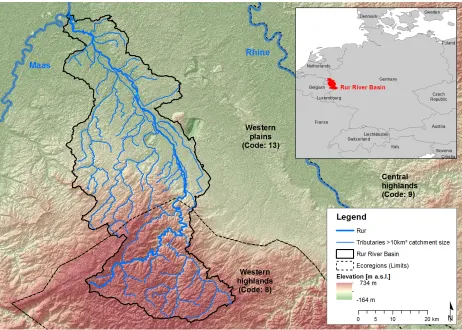
Research area
The German field survey method was applied in the Rur River Basin which is located mainly in the German state of North Rhine-Westphalia sharing small parts with the Netherlands and Belgium (Figure 1). The river basin covers an area of 2340 km² and contains approximately 2500 km of rivers and creeks. The main Rur River
bridges a height difference along its 165 km course of 643 m, with its source located at 660 m.a.s.l. and its mouth at 17 m.a.s.l. The average annual rainfall is 855 mm. In the southern highland regions an annual rainfall of up to 1560 mm is possible (MUNLV 2009). The study area is dominated by rural land use types (grassland, forest and cropland) with the exception of several urban areas (approx. 10 % of the total area).
Materials and Methods
16
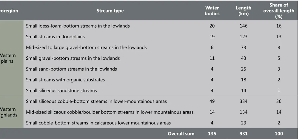
Journal of Natural Resources and Development 2013; 03: 14-26The herein presented work focuses on the German part of the river basin covering 2085 km² (91 % of the total area). Only those streams were considered in this study, which comprise a catchment area of at least 10 km². Catchments with this minimum size represent the basic management units according to the European Water Framework Directive. Therefore 931 km of rivers and creeks of the Rur River Basin were assessed by using the German field survey method (approximately 37 % of the river basin’s streams).
German field survey method for hydromorphological assessment of streams
The German field survey method assesses the structural quality of streams and serves as the basis for local to regional river maintenance and development (LAWA 2000). The streams are assessed over their full length, dividing them into segments. The segment length is determined by the channel width (e.g. a 100 m length is used
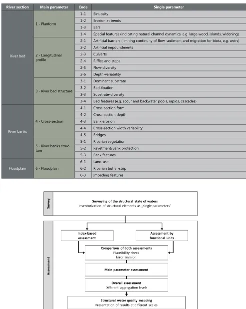
for a river up to 20 m wide; 500m-segments for a river wider than 20 m) (Scheifhacken et al. 2012). The determination a segment’s hydromorphological quality is based on 25 parameters, which are assessed by visual inspection (Table 2). For each parameter, the observed state is determined using a series of options: for example, low and very high are two of five options for describing flow diversity.
The 25 single parameters are stepwise aggregated into six main parameters, which are further aggregated into river sections (river bed, river banks and floodplain) and a final overall score resp. class. This aggregation is based on simple mean value calculation.
The plausibility of the field results is tested by a cross-check using index-based and functional unit approaches (Figure 1). Deviations between the computed index-based scores from the single parameters and the functional units derived from expert opinion are corrected and thereby the assessment quality is assured (Raven et al. 2002).
This river basin was chosen for this study due to its great variability of river types. The Rur River basin takes part in two ecoregions according to Illies (Illies 1978; Hering et al. 2004) – the Western plains (Ecoregion 13) and the Western highlands (Ecoregion 8). The ecoregion approach serves as a basis to define 28 different German river types (Pottgiesser and Sommerhäuser 2008) of which ten can be found in the Rur River basin (Table 1).
The stream types of the Western plains are characterized by meandering planform, no pronounced valley forms and sandy river bed substrate with a high share of organic material. The stream types of the Western highlands are characterized by V- and U-shaped valleys, low sinuosity and high substrate diversity composed of sand, gravel, rocks and dead wood.
Ecoregion Stream type bodiesWater Length (km) overall length Share of
(%)
Western plains
Small loess-loam-bottom streams in the lowlands 20 146 16
Small streams in floodplains 19 123 13
Mid-sized to large gravel-bottom streams in the lowlands 6 73 8
Small gravel-bottom streams in the lowlands 11 43 5
Small sand-bottom streams in the lowlands 4 25 3
Small streams with organic substrates 4 18 2
Small siliceous sandstone streams 4 14 1
Western highlands
Small siliceous cobble-bottom streams in lower-mountainous areas 49 334 36
Mid-sized siliceous cobble/boulder bottom streams in lower mountainous areas 14 134 14
Small cobble-bottom streams in calcareous lower mountainous areas 4 23 2
Overall sum 135 931 100
17
Journal of Natural Resources and Development 2013; 03: 14-26Table 2. The 25 single parameters of the German field survey method and their aggregation into main parameters and river sections.
River section Main parameter Code Single parameter
River bed
1 - Planform
1-1 Sinuosity 1-2 Erosion at bends 1-3 Bars
1-4 Special features (indicating natural channel dynamics, e.g. large wood, islands, widening)
2 - Longitudinal profile
2-1 Artificial barriers (limiting continuity of flow, sediment and migration for biota, e.g. weirs) 2-2 Artificial impoundments
2-3 Culverts 2-4 Riffles and steps 2-5 Flow-diversity 2-6 Depth-variability
3 - River bed structure
3-1 Dominant substrate 3-2 Bed-fixation 3-3 Substrate-diversity
3-4 Bed features (e.g. scour and backwater pools, rapids, cascades)
River banks
4 - Cross-section
4-1 Cross-section form 4-2 Cross-section depth 4-3 Bank erosion
4-4 Cross-section width variability 4-5 Bridges
5 - River banks struc-ture
5-1 Riparian vegetation 5-2 Revetment/Bank protection 5-3 Bank features
Floodplain 6 - Floodplain
6-1 Land-use
6-2 Riparian buffer-strip 6-3 Impeding features
18
Journal of Natural Resources and Development 2013; 03: 14-26The hydromorphological assessment is calibrated against a hypothetic natural or near-natural reference state of the above mentioned river types (Šípek et al. 2010). Therefore, a pre-requisite for the survey is to define the potential natural condition of a river as the basis for the hydromorphological quality assessment (Kamp et al. 2007). The final assessment comprises a seven-band classification ranging from ‘unchanged’ to ‘completely changed’ (Table 3).
Analyzing the hydromorphological state at different spatial scales
The overall hydromorphological state is analyzed for the entire the Rur River Basin. After scoring the overall assessment of each stream segment according to Table 3, the results were grouped into different regional subsets and compared with each other (Rur River vs. tributaries, Western Plains streams vs. Western Highlands streams). The potential difference regarding the hydromorphological quality of these subsets was determined by non-parametric Mann-Whitney-Test with a statistically significant level set at p < 0.05 in the Section Assessment results at different aggregation levels and spatial scales. The method’s capability for detecting specific hydromorphological potentials and deficits is given on the river reach scale. As an example the assessment results of the main parameter River Bed Structure and the single parameter Riparian Buffer-Strip for the Rur River are presented in Section Assessment results at different aggregation levels
and spatial scales.
A detailed analysis of the 25 single parameters is demonstrated for three 500m-segments of the Rur River (one restored segment and one up- and downstream of the restoration, respectively) in Section Assessment results at different aggregation levels and spatial scales. The monitoring capacity of the method is tested by comparing the results with former assessments of the restored stream segment. The restoration effects were analyzed based on the differences in hydromorphological quality before and after the restoration.
Evaluation of the method’s applicability
We conducted interviews with 36 experienced staff-members of the mapping campaign using a standardized ordinal-polytomous questionnaire (Oppenheim 2000) with a five-step verbal rating scale (Table 6). All participants hold at least a Bachelor degree in Geography. The question of interest for this study was: ‘How do you rate the applicability of the single parameters of the German field survey?’. In this case the applicability signifies the assessability of the hydromorphological element or process, which is represented by each parameter and has to be observed and evaluated in the field (e. g. bank erosion). We analyzed the results by calculating the percentage of the campaign members answers for each single parameter.
Final scoring
index 1.0-1.7 1.8-2.6 2.7-3.5 3.6-4.4 4.5-5.3 5.4-6.2 6.3-7.0
Final class 1 2 3 4 5 6 7
Description Unchanged (natural) changedSlightly Moderately changed Distinctly changed Obviously changed changedStrongly Completely changed
Table 3. Scores and classes of the German field survey method for river habitat monitoring and assessment. The final scoring index is the result of mean value calculation of the single parameters.
Standardized answer Description
Very easy The assessment of the parameter is feasible without any difficulty in all cases.
Easy The assessment is problematic only in exceptional cases.
Intermediate difficulty The assessment is problematic in some cases. Difficult The assessment is often problematic. Very difficult The assessment is always problematic.
Table 4. Standardized answers of the questionnaire regarding the assessment difficulties of the 25 single parameters of the German field survey method.
Results
Assessment results at different aggregation levels and spatial scales
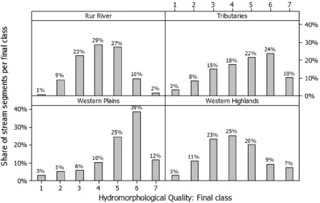
River basin scale
According to Figure 3 the overall hydromorphological quality
19
Journal of Natural Resources and Development 2013; 03: 14-26Figure 3. Comparison of the overall hydromorphological quality inside regional subsets. The upper two histograms show the differences of hydromorphological quality by aggregating the water bodies qualities into main Rur River and its tributaries respectively. The two histograms below aggregate the same water bodies according to their ecoregion classification.
Subset River bed [MED] River banks [MED] Floodplains [MED]
Rur River 4.0* 3.8** 4.0**
Tributaries 4.3* 4.8** 5.5**
p-value 0.04 <0.001 <0.001
Subset River bed [MED] River banks [MED] Floodplains [MED]
Western plains 5.3** 5.5** 5.5**
Western mountains 3.3** 3.5** 5.0**
p-value <0.001 <0.001 <0.001
Table 5. Comparison of the hydromorphological quality inside regional subsets (Main river vs. tributaries; ecoregion Western plains vs. ecoregion Western mountains) and regading different river sections. (** indicates a significant difference at p <0.001; * indicates a significant difference at p <0.05).
hydromorphological quality inside the Ecoregion Western Plains (MED Western Mountains = 4.0, MED Western Plains = 5.4, p < 0.001). This draws the attention regarding restoration efforts towards the tributaries of the Western Plains.
By looking further into the different river sections (river bed, river
bank and floodplains) and their hydromorphological quality the restoration focus in consequence is on the river banks of tributaries in the Western Plains and the floodplains of tributaries in both the Western Plains and the Western Mountains (Table 5). Also the river bed of the Rur River and its tributaries inside the Western Plains should be taken into consideration for restoration.
River reach scale
At the river reach scale specific river basin management can be handled, such as:
Good habitat characteristics for benthic invertebrates and fish provided by river bed: selection of stream segments with unchanged,
slightly changed or moderately changed river bed structure (Assessment class of the main parameter River bed structure ≤ 3). Riparian buffer strips missing or not fulfilling certain requirements regarding width and vegetation composition: selection of segments with distinctly to completely changed buffer strips (Assessment class of single parameter Riparian buffer strip > 3)
20
Journal of Natural Resources and Development 2013; 03: 14-26Figure 4. Analysis of the assessment results regarding specific river basin management issues. The colors in this case do not represent assessment classes. They illustrate hydromorphological potentials (green) and deficits (red).
In the case of the Rur River improving river bed structures (e.g. installation of fixed large dead wood) and riparian buffer strip conditions (e.g. land use conversion and reforestation) should be focused in the lower and middle reach (Figure 4).
River segment scale
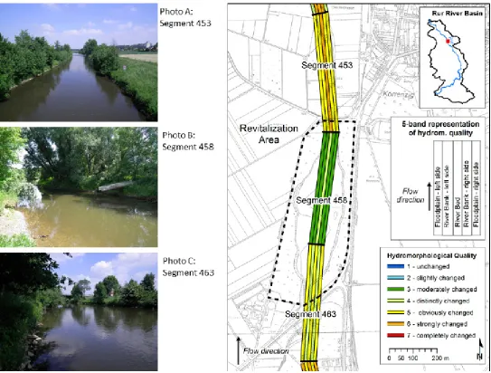
At the river segment level the hydromorphological differences represented by river beds, river banks and floodplains can be clearly observed in Figure 5. The 5-band representation of provides
a straight-forward evaluation of single stream segments and their hydromorphological qualities inside the river bed, river banks and floodplains. It also enables a fast comparison of adjacent segments. In Figure 4 for example, clear differences in all sections can be observed for the segment 458 and its adjacent segments up- and downstream.
The analysis of the single parameters show that the three segments mainly differ in terms of sinuosity, flow-diversity, depth-variability, cross-section variability and the characteristics of the riparian vegetation and nearby land use (Table 6).
The method can also be used for a rapid monitoring of restoration success in terms of hydromorphological alteration. The segment 458 of the Rur River was assessed using the German field method before its restoration in 2001 and eleven years later in 2012 (Figure 5 and Table 7). The hydromorphological improvement can clearly be identified for all main parameters.
However, for a detailed comparison of a ‘before-after restoration’ habitat quality taking into account species-specific ecological requirements, high-resolution assessment methods have to be applied (Harby et al. 2005; Mouton et al. 2007; Parasiewics and Walker 2007).