The University of San Francisco The University of San Francisco
USF Scholarship: a digital repository @ Gleeson Library | Geschke
USF Scholarship: a digital repository @ Gleeson Library | Geschke
Center
Center
Master's Theses Theses, Dissertations, Capstones and Projects
1998
Impacts of nonpoint source water pollution in Castroville,
Impacts of nonpoint source water pollution in Castroville,
California
California
Christopher W. Berry
Follow this and additional works at: https://repository.usfca.edu/thes
Recommended Citation Recommended Citation
Berry, Christopher W., "Impacts of nonpoint source water pollution in Castroville, California" (1998). Master's Theses. 1009.
https://repository.usfca.edu/thes/1009
The author of this thesis has agreed to make available
to the University community and the public a copy of this thesis project.
Unauthorized reproduction of any portion of this thesis is prohibited.
The quality of this reproduction is
contingent upon the quality of the original copy submitted.
UNIVERSITY of SAN FRANCISCO University of San Francisco Gleeson Library/Geschke Center
2130 Fulton Street
IMPACTS OF NONPOINT SOURCE
ABSTRACT
IMPACTS OF NONPOINT SOURCE WATER POLLUTION IN CASTROVILLE, CALIFORNIA
This study assesses environmental impacts of agricultural nonpoint source water pollution upon the surrounding wetlands, and nearshore environments of Castroville, California This study was conducted by evaluation of the major factors involved in such processes, including local soil characteristics, land uses, water quality , and finally, the aquatic resources of this area that may be impacted.
A ranking system was devised that rates the potential for these factors to contribute to a nonpoint source water pollution scenario. Each factor for each site was given a weight ranging from 0-3 respectively representing increasing levels of contribution to the nonpoint source water pollution scenario. The compilation of such weights was then assessed for the qualitative
determination of nonpoint source water pollution impacts at each site.
The study showed that a great potential for nonpoint source water pollution to impact aquatic resources in the area does exist. Numerous sites within the study area were characterized by erosion and runoff prone soils, intensive agricultural land use, presence of levels of organic chemical residues above the desired Maximum Toxin Residue Level limits, and their great inherent ecologic value and influence upon other habitats and ecosystems instrumental in the maintenance of ecologic, and economic health of the Monterey Bay area.
IMPACTS OF NONPOINT SOURCE
WATER POLLUTION IN CASTROVTLLE CALIFORNIA
This Thesis is Written By
Christopher W. Berry
This thesis, written under the guidance of the Faculty Advisory Committee, and approved by all its members, has been accepted in partial fulfillment of the requirements
for the degree of:
Master of Science in
Environmental Management
at the
University of San Francisco
Thesis Committee:
^ W . Lee Kuhre Date Chairperson ,
j l l i . .
Irene Garvey \ Date aern Ecological Associates
Brown, Director Date ! Environmental Management Program
Stanley D. Nel, Dean Date College of Arts and Sciences
VITA AUCTORIS
Name:
Baccalaureate Degree: Major:
College:
Graduated:
Christopher W Berry Bachelor of Arts Biological Sciences University of California, Santa Barbara
ACKNOWLEDGEMENTS
I would like to thank, among others, Bob Harper, Lyle Hillegas, Irene Garvey, Robin Oaks, Dave Richo and the whole Berry clan, for listening to my whining, and for providing support and constructive criticism. I would also like to thank the folks at the City of Santa Cruz Water Quality Laboratory, who always wondered what kept me so busy, and the staff at the University of San Francisco for all their time and hard work. Finally, thanks Geezer, for being a good dog while I went crazy trying to finish this study.
TABLE OF CONTENTS
Abstract i Thesis Approval ii Vita Auctoris iii Acknowledgements iv Table of Contents v List of Tables vii List of Figures viii List of Appendices ix
Chapter 1 - Introduction
Background 1-1 Statement of the Research Problem 1-5
Subproblem 1 - Soils 1-5 Subproblem 2 - Land Use 1-5 Subproblem 3- Water Quality 1-6 Subproblem 4 - Aquatic Resources 1-6 Subproblem 5 - Impacts of Nonpoint Source Water Pollution 1-6
Hypotheses
Subhypothesis 1 1-6 Subhypothesis 2 1-6 Subhypothesis 3 1-7 Subhypothesis 4 1-7 Subhypothesis 5 1-7
Assumptions 1-8 Delimitations 1-8 Definition of Terms and Abbreviations 1-9
Methodology 1-15
Chapter 2 - Review of the Related Literature
Introduction 2-1
Soils 2-2 Land Use 2-4 Water Quality 2-10 Aquatic Resources 2-11 Impacts of Nonpoint Source Water Pollution 2-13
Conclusions 2-17
Chapter 3 - Research Methodology
Overview 3-1 Data
Soils 3-5 Land Use 3-6 Water Quality 3-7 Aquatic Resources 3-8 Impacts of Nonpoint Source Water Pollution 3-9
Chapter 4 - The Data and Analysis
Introduction 4-1 Data
Soils 4-2 Land Use 4-23 Water Quality 4-36 Aquatic Resources 4-41 Impacts of Nonpoint Source Water Pollution 4-46
Chapter 5 - Conclusions
Impacts of Nonpoint Source Water Pollution 5-1
Economic 5-1 Biodiversity 5-3
Discussion 5-5
Appendices
Appendix A - Water Quality A-l Appenidix B - Aquatic Resources B-l
Literature Cited L-1
LIST OF TABLES
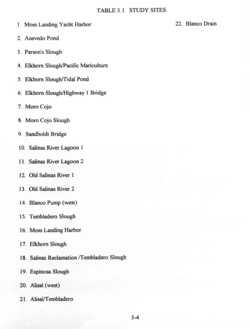
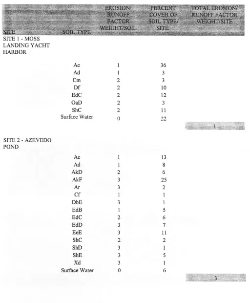
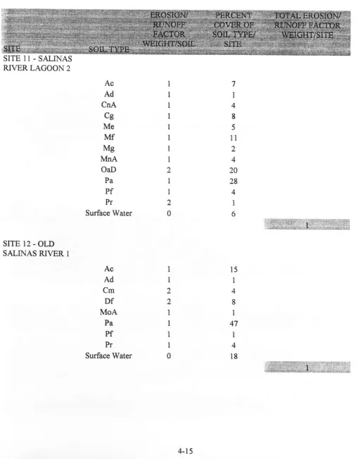
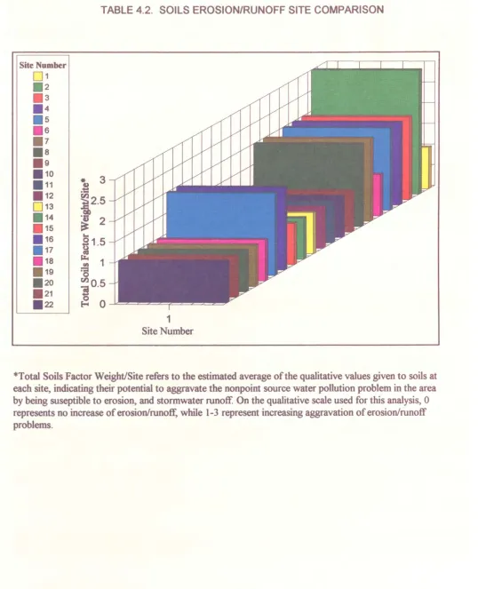
Table 3.1 Study Sites 3-4 Table 4.1 Soil Summary/Site 4-10 Table 4.2 Soils Erosion/Runoff Site Comparison 4-21
Table 4.3 Land Use Types 4-23 Table 4.4 Land Use Summary/Site 4-25
Table 4.5 Land Use Site Comparison 4-37 Table 4.6 Water Quality - Chemical Residues//Site 4-39
Table 4.7 Water Quality - Site Comparison 4-41 Table 4.8 Aquatic Resource - Summary/Site 4-43 Table 4.9 Aquatic Resources - Site Comparison 4-44 Table 4.10 Impacts Of Nonpoint Source Water Pollution/Study Site 4-47
Table 4.11 Impacts Site Comparison 4-51
LIST OF FIGURES
Figure 1.1. Map of the General Study Area 1-18
Figure 4.1. Map of Study Sites 4-55 Figure 4.2. Map of Monterey Bay Circulation Patterns 4-56
LIST OF APPENDICES
A. Water Quality Data A-l
B. Aquatic Resource Data B-l
CHAPTER 1 INTRODUCTION
Background
Because nonpoint source water pollution, by definition, originates from diffuse sources, it is not easily identified. Sediment, nutrients, pathogens, pesticides, metals and toxic chemicals are transported from their origin in construction sites, agricultural areas, parking lots, streets, etc., and enter surface waters from stormwater runoff over the landscape, through storm drains, culverts, ditches, drains and the like. The increasingly frequent loss of riparian corridor buffer zones of native vegetation, disturbance of the runoff absorbing topsoil, as well as the prevalence of potentially hazardous substances in our soil and water, on our roads, parking lots, fields, and on construction sites all help to pose a potentially greater threat to habitats, wildlife, and human uses of these waters than the point sources that both popular consciousness and legislative efforts have been primarily focused upon.
Though the value of environmental quality is not easily defined, it cannot be
disputed that wetland areas, and their associated habitats serve many purposes, both
anthropocentric and otherwise. Wetlands providefish and wildlife habitat, ground water
recharge, water quality enhancement through flood and erosion control, aesthetic,
economic, and recreational resources. However, conservative estimates consider at least
50 percent of our nation's wetlands to have been destroyed since the time of our country's
colonization by the first white settlers (Berry and Dennison 1993). Increasing awareness
of wetland issues have resulted in legislation such as the Clean Water Act, and subsequent
and Scenic River Program, etc.
The environment of the Monterey Bay area is considered by scientists,
environmentalist, recreationalists, and others to be such a valuable asset that it has been
designated a National Marine Sanctuary. While much of the area that this study is
concerned with is not within the boundaries of this sanctuary, it is important to understand
the role and effects of the discharge of these fresh, and brackish waters (Salinas River,
Moro Cojo Slough, Elkhorn Slough, etc.) which feed into the bay in the Castroville area.
The environment of these fresh and brackish water bodies supports breeding and nursery
grounds for many species of fish, invertebrates, and other flora and fauna. These species
are, in many circumstances, commercially valuable as well as fundamental in the
foundation of the food chain within the bay environment which supports commercially
valuable, threatened and endangered species such Chinook and Coho Salmon, Steelhead
Trout, the Southern Pacific Sea Otter, Blue and Fin Whales, the California Clapper Rail,
Brown Pelican, etc. (National Oceanic and Atmospheric Administration 1992).
Monterey Bay is one of the larger bays on the west coast of North America. The
importance of such an area is realized when one considers the enhancement of near shore
ocean mixing (upwelling), great spatial heterogeneity in the Monterey Submarine Canyon,
diversity of coastal wetlands, and the like are considered. The Monterey Bay area
supports not only the vastly productive agriculture and fisheries industries, but also has an
important economic foundation in other water related industries such as whale watching,
imperative to consider the health of the aquatic environment in this area (National Oceanic
and Atmospheric Administration 1992).
Beyond the immediately relevant issues of maintaining environmental health and
for the inherent value of pristine ecosystems, there are obvious human environmental
health and safety issues to be considered, as nonpoint source water pollution poses threats
to other beneficial uses of these waters. The surface waters of watersheds in the
Castroville area drain what has been described as the "salad bowl of the world"
(Fitzsimmons, M.E. 1993) —a reference to the area's rich agricultural productivity and
diversity. This makes the potential for runoff from fields to transport pollutants to these
waters, which are such an integral part of the Monterey Bay environment, very great.
Agricultural activities associated with large scale commercial production such as
fertilizing, spraying with pesticides and herbicides, tilling, and irrigating, have the ability to
influence the quality and quantity of runoff. Erosion is often accelerated with tilling,
which breaks up the organic, absorbent layer of the soil. Irrigation not only carries this
soil away, but transports agri-chemicals, and other potentially environmentally threatening
substances that have bound to the topsoil (Christensen, S.D., Fawcett, R.L., Tierney, D.R
1994). With these compromised soil conditions, a scenario exists whereby stormwater has
an increased ability persistently to strip the soil of its organic layer. Additionally, many
degradation products of commonly used pesticides can be more toxic than the originally
applied pesticide because of their increased persistence in the environment, but also
in surface waters (Oakden, J.M., Oliver, J.S. 1988). In general, the behavior of these
break-down products, or metabolites, is not well understood, nor is registration for
degradation products of pesticides required. Thus, it is hard to determine what quantities
of these products may have the potential to enter the environment.
This study attempts to develop a deeper understanding of watershed issues in the
Castroville area by identifying the factors most directly related to the perpetuation of the
current nonpoint source water pollution state. As much of the landscape surrounding
Monterey Bay is characterized by coastal wetlands and their associated provisions for
great biodiversity, recreational and other activities, and heavy agri-industrialization, the
process of determining agri-industrial based nonpoint source water pollution entails
consideration of soil characteristics, land uses, and agri-chemical residue levels which
affect water quality (and its associated aquatic resource "value" as measured by its ability
Statement of the Research Problem
This research will examine environmental impacts of agricultural nonpoint source water pollution in the Castroville, California area. Because persistent pesticides associated with agri-industrial activities are often transported to surface waters in association with suspended sediments, the environmental impacts of nonpoint source water pollution can be assessed by analysis of the roles played by patterns of soils types, land use types,
agri-chemical residues in surfacewater, and the aquatic resources potentially threatened
by compromised water quality in the runoff" scenario that exists in the area. An
examination of data for a number of different study sites within the general study area, in a format that provides a qualitative depiction of each factor mentioned above for each site will provide the basis for determining the degree to which agricultural nonpoint source water pollution impacts the estuarine and nearshore marine environments of the
Castroville and Monterey Bay area.
Subproblems Subproblem i-Soils
Subproblem one is to determine if significant impacts result from erosion of soils, and subsequent runoff of suspended sediments to surrounding surface waters. This determination will be made by examination of the relative soil erosion/runoff
characteristics of each study site within the study area. Subproblem 2-Land Use
Subproblem 3-Water Quality
Subproblem three is to determine if significant impacts result from existing water quality problems. As the result of aggavated soil erosion, suspended sediments and their associated chemical residues often runoff from agri-industrial activities to local surface waters. Thus, the determination of the existence of impacts due to existing water quality problems may by made by examination of local filter feeder, and other bioassay data.
Subproblem 4-Aquatic Resources
Subproblem four is to determine if significant aquatic resources exist which may be impacted by runoff induced water quality changes. This determination will be made by examining the extent to which surface waters exist within the study area.
Subproblem 5-Impacts of Nonpoint Source Water Pollution Subproblem five is to determine the nature of significant impacts to the surface waters of the Castroville area in particular, and the Monterey Bay environment in general. The determination of impacts of nonpoint source water pollution will be made by
examination of the conglomeration of data regarding soils, land use, water quality, and aquatic resources at each study site within the study area.
Hypotheses Sub-Hypothesis 1
By increasing suspended sediment load in local surface waters, erosion and runoff of soils may contribute to the significant impacts by aggravating the local nonpoint source water pollution scenario.
Sub-Hypothesis 2
by aggravating the local nonpoint source water pollution scenario. Sub-Hypothesis 3
By continual transport to surface waters, and subsequent accumulation in suspended and nonsuspended sediment, as well as in the animal tissues, agri-industrial related chemical residues in the surface waters may contribute to significant impacts. The existence of high levels of agri-chemical residues in body tissues of animals native to the study area, and filter feeders in particular, in conjunction with the fact that persistent organochlorine agri-chemicals have not been in use for decades, indicates that agri-chemicals are associated with suspended sediment, and have been transported to surface waters, and through the food chain on an ongoing basis for an extended period of time.
Sub-Hypothesis 4
The extent to which agri-industrial runoff may have negative impacts on the aquatic environment, in part depends on the character of that environment which is threatened. Because the area in question encompasses the major estuaries of the Monterey Bay, thus extensive negative impacts to fisheries, recreation, and other inherently and economically, aesthetically, and environmentally valuable resources
provided by the Monterey Bay environment may result from the exacerbation of the local nonpoint source water pollution scenario by the increased incidence of runoff of
agri-chemical laded suspended sediment in stormwater.. Sub-Hypothesis 5
A model which describes the impacts to the local environment can be developed using data which describes characteristics of soils, land use, water quality, and aquatic resources, and their role in potentiating the existence of a nonpoint source water pollution problem in the study area.
Assumptions
Assumption 1
Pollution in the form of runoff is a problem which has been occurring, and will
continue to occur.
Assumption 2
Runoff is influenced by characteristics of soils and land use.
Assumption 3
The quality of runoff can be indicated by water and suspended sediment chemistry,
and by bioassay data.
Assumption 4
Assessing the impacts of runoff are increasingly important in increasingly sensitive,
and diverse environments.
Delimitations
Delimitation 1
This study will not attempt to assess impacts of runoff unrelated to nonpoint
source water pollution.
Delimitation 2
The study will not attempt to assess mitigation measures for impacts related to
agricultural, or any other type of runoff.
Delimitation 3
The study will not attempt to assess impacts of nonpoint source pollution outside
the boundaries of: the Bennett Slough on the north, the Salinas River on the south, the
near shore waters of the Pacific Ocean on the west, and the eastern boundaries of the
watersheds which drain the western slopes of the coastal range of hills.
Delimitation 4
The study will not be concerned with issues of ground water quality.
Definition of Terms
Aquatic Environment: the complete range of external conditions, physical and biological,
in which an aquatic organism lives. This environment may include social, cultural and (for
humans) economic and political considerations, as well as more usually understood
features such as substrate, climate, food supply, and the like (Allaby 1994).
Biotic: the living components of an ecosystem, as distinct from the non living components
(Allaby 1994).
Environment: the complete range of external conditions, physical and biological in which
an organism lives. The environment includes social, cultural and (for humans) economic
and political considerations, as well as more usually understood features such as soils,
climate, food supply, and the like (Allaby 1994).
Ecosystem: a discrete unit that consists of living and non living parts interacting to form a
stable system. Fundamental concepts include the flow of energy via food chains and food
webs and the cycling of nutrients biogeochemically. Ecosystem principles can be applied
at all scales. For example, principles that apply to an ephemeral pond apply equally to a
lake, an ocean, or the whole planet (Allaby 1994).
Endangered Species: as defined by the Endangered Species Act, refers to a species of
plant or animal that is in imminent danger of extinction over all or a significant portion of
its range. Generally, five specific conditions must be met for a species to be considered
endangered: a) its population's death rate must exceed its birth rate; b) the species is
highly specialized and incapable of adapting to the environmental changes, c)the species'
habitat is seriously depleted or disturbed; d) the introduction of one or more or exotic
species poses a threat due to competition, predation, parasitism, or desease; or e)
environmental pollution threatens its viability or survival (Ashworth 1991).
Estuary: a coastal body of water which has a free connection with the open sea and where
fresh water, derived from land drainages is mixed with sea water (Allaby 1994).
Groundwater: water that occurs below the Earth's surface contained in pore spaces
within unconsolidated rock fragments and bedrock. Groundwater either passes through or
stands in the soil and underlying stratea, and is free to move under the influence of gravity
Most groundwater is derived from surface sources, though some is also introduced by
volcanic processes, and other sources (Allaby 1994).
Habitat: the living place of an organism as characterized by its physical or biotic
properties (Allaby 1994).
Heavy Metals: metals that have a density greater than 5g/cubic centimeter (Cu, Hg, etc.)
(Allaby 1994).
Invertebrates: animals without a skull and a vertebral column made of bone or cartilage
(e.g. mollusks, insects) (Allaby 1989).
Niche: the functional position of an organism in its envrionment comprising the habitat in
which the organism lives, the periods of time during which it occurs and is active there,
and the resources it obtains there (Allaby 1994).
Nonpoint source water pollution: the pollution of water bodies by diffuse sources such as
agricultural or urban runoff or aerial deposition. Conveyances for runoff, such as drainage
ditches and storm sewers, are generally classed as nonpoint sources. They are therefore
concentrated, but largely uncontrollable, sources such as livestock feedlots, parking lots,
and individual septic tank systems. Nonpoint source pollution is usually the most
important overall source of contamination in a water body. Ninety percent or more of the
total pollutant load may come from nonpoint source pollution, especially if treatment
plants have been installed for the point sources. Nonpoint source pollution is much more
difficult to deal with than is pollution from point sources because the pollutants come from
a large number of small, often unidentifiable sources making treatment impractical or
impossible. Control can, however, be implemented through limitations on land use.
Assessment for the need for control is made by measuring the amount of pollutant
contribution from a definable source region area (e.g. watershed). Some factors affecting
nonpoint source pollution are: the amount of rainfall, the slope of the land, the infiltration
rate of precipitation, soil types, and the amount of pollutants actually placed on the land
Pesticides : substances used to kill crop pests, including weeds, insects, rodents and fungi.
They are classified according to the type of pest organisms they kill most easily, as:
fungicides, rodenticides, insecticides, and herbicides. They may be further classified
according to their persistence in the environment (hard, or persistent, vs. soft, or easily
broken down). Examples of some types of pesticides include: organophosphates which
are organic compounds containing phosphorous, and organochlorines which are organic
compounds which contain chloride (Ashworth 1991).
Rare Species: according to California law, are confined to a small, specific habitat. They
are nowhere abundant throughout their range. Their range is so small that reduction in
habitat might cause them to be endangered. Some of these species are dependent on
wildlife management, so that management changes can cause the species to become
endangered (Ashworth 1991).
Riparian: pertaining to a river bank (Allaby 1994).
Spatial Heterogeneity: (patchiness) is a term referring to spatial and temporal variablity of
production, particularly in aquatic systems. In aquatic systems, horizontal and vertical
diffusion operate, and these physical processes cause space and time to interact. Physical
processes associated with winds and currents can produce aggregation of phytoplankton
(e.g. winds and currents in the Monterey Bay can produce microzones of upwelling in the
Monterey Submarine Canyon). Spatial and temporal variability in aquatic systems may be
important in maintaining species diversity (Hutchinson 1961), possibly because aquatic
systems are continually changing seasonally, so competitive dominance and exclusion
cannot be achieved (Krebs 1985).
Stormwater: surface runoff which is associated with storms, especially that associated
with urban areas. Stormwater is typically up to 100 times the normal flow of household
and industrial sewage carried by a city's sewage system and therefore cannot be handled
by the treatment systems. This runoff can be very heavily polluted, especially when it is
associated with the first rains of the season (the "first flush") (Ashworth 1991).
Surface Runoff: overland flow, the flow across the land surface of water which
accumulats on the surface when the rainfall rate exceeds the infiltration capacity of the
soil. The rate of infiltration, and therefore the possibility of surface runoff is determined
by such factors as soil type, vegetation, and the presence of shallow, relatively
impermeable soil horizons. Saturated overland flow can occur when a temporary rise in
the groundwater level (water table) inhibits infiltration and causes flow over the surface of
the soil (Allaby 1994).
Surface Waters: water which remains at or is close to the land surface, above ground that
is not saturated (Allaby 1989).
Suspended Sediment: particles small enough to be carried in suspension by moving water
(Allaby 1989).
Threatened Species: (as defined by the Endangered Species Act) is a species that is likely
to become endangered within the forseeable future throughout all or a significant portion
of its range. The categories of threatened species include rare species (those whose
by human activities or natural disasters), and species endemic to small areas that are
threatened by development. Species listed as threatened generally receive the same
protection as those listed as endangered. The goal in protecting threatened species is to
prevent them from becoming endangered (Ashworth 1991).
Toxic: a toxin is a poisonous substance of plant or animal origin. Toxins usually act at
specific sites in the body (e.g. neurotoxins affect nerves) (Allaby 1994).
Water Pollution: an alteration of the quality of the waters (of the State of California) by
waste to a degree which unreasonably affects either of the following:
-the waters for beneficial uses, such as domestic, municipal, agricultural and
industrial supply, power generation, recreation, aesthetic enjoyment, navigation and
preservation, and enhancement of fish, wildlife and other aquatic resources or preserves;
-facilities which serve beneficial uses (Central Coast Regional Water Quality
Control Board 1989).
Watershed: the land from which a stream gets its water. A drop of rain that falls
anywhere in the watershed of a given stream and does not evaporate back into the air will
eventually end up in the stream. Knowledge of boundaries is important in all forms of land
use planning because they define the limits of the impacts of activities that affect water
quality or quantity, such as soil disturbance, withdrawal of water from streams, or
pollution discharge, requiring planning for these activities to be done on a watershed wide
Abbreviations
A.M.B.A.G.: Association of Monterey Bay Area Governments
C.C.R.W.Q.C.B.: Central Coast Regional Water Quality Control Board.
D.W.R.: California Department of Water Resources.
M.T.R.L.: Maximum Toxin Residue Level.
N.M.F.S.: National Marine Fisheries Services.
N.P.S.P.: Nonpoint Source Pollution.
N.O.A.A.: National Oceanic and Atmospheric Administration
N.R.C.S.: Natural Resources Conservation Service.
S.M.W.P.: California State Mussel Watch Program.
S.W.R.C.B. State Water Resources Control Board
T.S.M.P.: Toxic Substances Monitoring Program.
U.S.D.A.: United States Department of Agriculture.
U.S.G.S.: United States Geologic Survey.
Methodology
This study employed the descriptive survey method. Secondary data relating to
each subproblem will be compiled from various agencies and assessed with regard to their
potential to contribute to the nonpoint source water pollution scenario at various sites
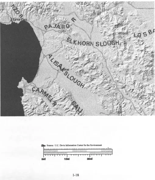
within the study area (see Figure 1.1. Map of the General Study Area), and the Monterey
Bay in general.
nonpoint source water pollution is varied. As is evident in previous studies, knowledge of
pollutant transport, erosion, hydrology, and various other environmental variables is
necessary before considering the processes and resources they may be affecting as
nonpoint source water pollution (Chapman 1992). When considering agricultural origins
of nonpoint source pollution, the relative importance of organochlorine based pesticides as
the primary threat to water quality seems clear. Because of their persistence in the
environment, toxicity of breakdown products, and susceptibility to being transported by
runoff with sediment (Baul, Garnham, Hucker, Baird, et al. 1994), data regarding erosion,
suspended sediment, and organochlorine residues was focused upon first. The assessment
of what they actually threaten followed.
The analysis of impacts to the aquatic environment in the study area involved
assessment of the various types of data (soils, land use, water quality, aquatic resources)
from the watershed(s) (58/005, and 48/005, as defined by the DWR) areas defined by the
Bennet Slough on the north, the nearshore waters of the Pacific Ocean on the west, the
Salinas River on the south and the eastern edges of watersheds as defined by the
California DWR (Fig 1.1). These boundaries are designated to limit the study of soils,
land uses, water quality and aquatic resources to a manageable area that is most likely to
include most types of coastal agricultural operations, and coastal habitats in the area.
Within the general area specific sites were assessed according to each subproblem.
For all subproblems a weight will be established (as detailed in Chapter 3) that figured into
marine, and riparian habitats within the study area. This procedure allowed for
development of a clear picture of which sites within the study area are most at risk, or
most likely to contribute to an overall nonpoint source water pollution problem in the
FIGURE 1.1. MAP OF THE GENERAL STUDY AREA
MMBP
t
ssssssbr
Source: U.C. Davis Information Colter for the Environment
•• • • • • • • • • • i • • • • 11 i» • i i i 111 i 11 i i i i I i i i i j — i i i | i i i i | i i « i | — - r - r
CHAPTER 2
REVIEW OF RELATED LITERATURE
Introduction
The Castroville area is very productive agricultural area. It is immediately adjacent to
similarly productive aquatic environments such as those of Elkhorn Slough, the Salinas River
Lagoon, and the Monterey Bay. Therefore, an investigation of literature, as it relates to the
effects of agri-industrial activities on water quality, is necessary. Though virtual monocultures of
crops are grown here (Fitzsimmons 1993), the diversity of aquatic systems and associated
lifeforms, and the diversity of soils and geography through which overland water flows provide
great opportunity for intensive study of their interactions (Fitzsimmons 1993).
The study of Elkhorn Slough, Elkhorn Slough Watershed Project (Monterey Coast
Resource Conservation District 1993), indicates the nature of this problem more thoroughly.
These studies consist of numerous analyses concerning the nature of degradation of the slough,
remediation of impacts to the slough, new best management practices for farmers to eliminate or
reduce such impacts, etc. Among the findings of the project is that sediment deposition from
erosion on public and private property and subsequent deposition on wetlands are existing
problems within the estuary. The primary cause of these problems is the transport of
contaminated eroded soils from the nearby watersheds which are heavily developed agriculturally
(Monterey Coast Resource Conservation District 1993).
These facts seem to correspond with findings of other studies. Agriculture can be shown,
seems to be a result of combinations of land uses and varying environmental conditions.
However, it is rare that such an agriculturally productive area would be adjacent to such a
relatively productive and pristine aquatic environment (Monterey Bay and the surrounding
watersheds that drain to it). Therefore, it is particularly important that consideration of potential
threats to the valuable resources of the bay posed by such activities in the area be undertaken.
Soils
In the analysis of particle transport of nutrients and anthropogenic substances, Water
Quality Assessments (Chapman 1992) draws the conclusion that any water quality assessment
program requires sediment analysis to be complete; though the point is made that sampling and
analysis procedures are in developmental stages and, therefore, somewhat unreliable. The study
emphasizes that highly polluted sediment, through resuspension and mobilization, may pollute a
localized environment long after it has left the point of origin.
These are important facts to consider as they again point toward the need for study of
erosion/suspended sediment characteristics of any study site. In addition, the point that particles
may transport pollutants to the aquatic environment long after they are introduced
anthropogenically is particularly relevant when one recognizes the quantities of toxic agricultural
chemicals used at our study site before concerted regulation was initiated. In addition, the fact
that these particles may cause a persistence of the chemicals in the environment suggests that at
the end of a rainy season, instead of being flushed free of all pollutants, aquatic systems may be
overwhelmed with seasons', or even multiple years' worth of resuspended polluted sediment
(Chapman 1992).
the first and foremost negative impact of agriculture on the environment is soil erosion. As with
similar studies, this study emphasizes the pathways through which chemicals reach the
environment, with particular focus placed upon toxicity of particular chemicals and their
persistence in the environment. Methods of chemical degradation, which are often dependent
upon the same environmental characteristics that define ecosystems: wind, temperature, water
chemistry, turbidity, etc., are detailed.
The study provides further evidence for the need to examine the role of weather, soil
conditions, hydrology, and other environmental characteristics in consort with particular chemical
characteristics in the analysis of chemical degradation. This is in order to determine persistence of
the chemical in the environment. In addition, the relationship of soil erosion and water pollution
is, again, well illustrated, and the need for a deeper understanding of such relationship(s) is
emphasized (Tivy 1990).
The nature of pesticide activity in the environment is the topic of Fate of Pesticides and
Chemicals in the Environment (Schnoor 1992). Among the many technically loaded aspects of
this analysis is discussion of transport of chemicals in water, factors affecting field losses of
pesticides, and biological transformation of such chemicals.
This study is important in that it provides information regarding the ways that pesticides
may move through a particular environment. This study may be especially pertinent in that
activity of specific categories of chemicals are assessed under different field/environmental
conditions, and thus one may more readily apply such concepts of pesticide transport,
degradation, biomagnification, etc., to case studies such as the one at hand. It emphasizes, among
source pollution scenario (Schnoor 1992).
The role of soil erosion in a particular nonpoint source pollution scenario cannot be
underestimated. The effects of increased sediment load can vary widely, though the net result is
often the debilitation of habitat. Increases in turbidity can reduce water oxygen levels and limit
plant photosynthetic capabilities. Changes in substrate of streams affect fish spawning behavior
and affect water chemistry. Agri-chemical residues being transported on suspended sediment,
increases in erosion, and activities which would increase the detrimental effects of existing
suspended and settled sediments can also be the cause of great perturbation in surface water
environments.
Land Use
It is apparent that land use can play a major role in the creation and aggravation of
nonpoint source water pollution. Water Pollution by Fertilizers and Pesticides (Organization for
Economic Cooperation and Development 1986) analyzes the runoff problem from an
interdisciplinary, international angle. The study covers agricultural runoff from two different
sources: animal waste and fertilizer/pesticides/herbicides, etc.
While the study is not as detailed, technically, as other similar studies are, it does shed
some light on a more comprehensive cost-benefit scenario of high input vs. low input of
agri-chemical fanning techniques. This is achieved by analysis of water pollution management
within the socio-economic context as well as the natural environmental context. Therefore, an
impact assessment of agricultural chemical runoff can be made within a more nonpartisan
consciousness. In addition, the interdisciplinary, international nature of this study provides
runoff (Organization for Economic Cooperation and Development 1986).
Another analysis of water quality management through management of pesticides,
Managing Pesticides for Crop Production: Practical Grower Guides (Hornsby, Butler, and
Brown 1993) approaches the problem from a similar angle as the previously mentioned study.
The present study was designed to allow growers to select pesticides on the basis of water quality
impacts, as well as cost and efficacy.
The study focuses on the environmental fate and toxicity of pollutants, soil and terrain
characteristics and hydrologic characteristics, and pest management needs of a site in order to
determine potential impacts on water quality of the associated watershed. Pesticide properties
considered include: adsorption coefficients, degradation half-life, lifetime health advisory level,
and aquatic toxicity. Soil Conservation Service soil ratings were combined with this information
to help provide a solid foundation upon which to base further pest management decisions.
With the example of this study, a model for site specific analysis of potential water quality
impacts is realized. Thus, this study provides pertinent information regarding methodology for
determining potential impacts of particular agricultural chemicals at particular sites. Because each
site may have even minute differences in soils, hydrology, chemical applications, irrigation, etc.,
the information provided by this study is especially relevant to any site assessment (Hornsby,
Butler, and Brown 1993).
Farming practices, as well as the environment in which they are practiced, are paramount
in determining the potential for impacts to the aquatic environment. Among factors to be
considered in determining the potential for impacts are tillage practices, chemical application,
(Isensee 1993), it was found that runoff was greater for no-till than for tilled land when there was
less than one week between rains. The tilled plot then experienced greater runoff. The number of
agricultural chemicals found in runoff was greatest after the first rain, and chemical concentrations
varied with the type of chemical and till method.
The study illustrates two important points with regard to this thesis. The first point is that
the frequency of hydrologic events and their duration can affect runoff dramatically. The second
point is that different chemicals follow different pathways into the environment. Therefore, with
some agricultural chemicals an association with eroded soil may be found, while others may be
water soluble and thus associated with the runoff itself (Isensee 1993).
Further study of farming practices and related runoff/erosion issues in Rain, Runoff
and Underground Water (Comis 1992) reveals that no-till farming is more sustainable in terms of
runoff quality and quantity. In addition, it is also more energy efficient because there is less
disturbance of the soil organic layer, less loss of topsoil to erosion, and less labor intensive. While
the increased retention of water may provide cause for concern of groundwater pollution by
chemical residues in soil, the study found no evidence of chemical levels in monitoring wells that
were above levels considered to be unhealthful.
Analysis of farming practices seems to be further supported by this study. Obviously tilled
agricultural lands will produce more runoff and erosion (depending on soils, terrain, etc.) than
no-till or conservation-till lands. With land use/farming practices data for an area, it may be
possible further to define the potential for threats to water quality and aquatic ecosystems, as well
as provide direction in conserving soils, and to design more financially, as well as ecologically,
The Impact of Conservation Tillage on Pesticide Runoff into Surface Waters (Fawcett,
Christensen, Tierney 1994) provides more analysis of the methods of transport of agri-chemicals
into surface waters. In the process of this analysis, assessment of best management practices for
agriculture are also considered. Among the findings of this study are that conservation-tillage,
which involves disturbing the topsoil and burying crop residues by methods of chisel plowing,
ridge tillage, etc., resulted in increased water infiltration, reduced erosion, and slowed overland
flow. All these are benefits of conservation-tillage and result, generally, in less degradation of
surface water quality. Therefore it was established that, not only do agricultural practices
influence runoff signigicantly, but additionally, they are able to be modified to be less damaging to
adjacent ecosystems without incurring significantly greater inputs of labor and other production
costs. In fact, it was determined that soils which had been tilled in the conservation mode were
more able to absorb and retain moisture and nutrients, thus making them more productive than
traditionally worked soils.
In addition to detailing benefits of conservation-tillage, the study provides insight
to mechanisms for pesticide losses from fields to surface waters. Pesticide loss with sediment and
water carriers is determined by the volume of carriers and the concentration of chemicals in, or
on, the carriers. Concentration of chemicals in sediment and water are determined by the quantity
of chemicals applied, their persistence, solubility, degree of adsorption and location of chemicals
in the soil profile (Fawcett, Christensen, Tierney 1994).
Agricultural Ecology and the Environment (Stinner and Paoletti 1989) also focuses on
farming practices and associated potential for runoff. Among the findings of this study are that
studies referenced by the authors indicate that grasslands are characterized by less overland flow
(runoff) than is typical of cultivated crop land because grass provides a more consistent organic
layer in the soil. This increases infiltration capacities and provides a more continuous cover which
intercepts more rainfall. All of this points to cultivated lands, especially conventionally cultivated
lands, being more prone to runoff problems than natural habitats or non-tilled lands (Stinner and
Paoletti 1989).
Another study in Agriculture and the Environment (Briggs, Courtney 1985) makes a
distinct point by stating that agricultural runoff, with all the other potential contributors to areas
where its results are shown, has not and may not ever be identified to a level necessary for
adequate analysis of the practices which produce it. This is an important point to consider in
assessing any water quality impact, for if a definite source of impacts cannot be ascertained, then,
surely, remediation or mitigation would be very difficult (Briggs and Courtney 1985).
The United States Environmental Protection Agency Journal article, Introducing
Nonpoint Source Pollution (Griffin 1991), speaks to this problem of identifying nonpoint sources.
The relatively vague origins of nonpoint source pollution is one of the main reasons why it has
been slow to gain public recognition and subsequent activity in the form of new, best management
practices for responsible parties, legislation, etc. The article declares that as much as 50 to 70
percent of impaired or threatened surface waters are affected by nonpoint source pollution from
agricultural activities.
The article goes on to detail the history of consciousness and policy making regarding
nonpoint source pollution and emphasizes the need for an enhanced effort to learn the
the article makes an important point: control strategies proceed from two basic principles, both
of which involve land use practices. To control nonpoint source pollution, first, the land must be
able to retain water, and second, the pollutants that may run off must be minimized in quantity and
quality (Griffin 1991).
An interesting point to be considered in light of the knowledge of the importance of land
use considerations when discussing nonpoint source water pollution assessment is that agriculture,
for all its potential pitfalls, is not only a necessity, but is highly desirable to other, more damaging
land uses, especially in the coastal zone. According to Agriculture in the Coastal Zone
(Rodriguez 1982) the relative sensitivity of coastal lands as well as aesthetic value are the reasons
behind the California Coastal Act's stated "preference" for agricultural use of coastal lands when
proposed developments loom on the horizon.
Agricultural land uses can act as buffers to urban areas and parks and can also serve the
purpose of providing economically productive land use in areas where other economically
oriented land uses (residential, commercial, industrial development) would detract from the
natural environment in ways much less subtle than those associated with agriculture (smog, traffic,
noise, accelerated runoff from paved surfaces, etc.) (Rodriguez 1982).
While it is important to understand the role of the socio-economic/natural environmental
balance in land use decisions, it is also necessary to analyze the estimated, if subtle, and unclear
detrimental effects of these decisions if a long range, sustainable use of the land is to be achieved.
As we have seen, impacts can be determined by analysis of the land being used: hydrology, soils,
terrain, wind, etc.; the way in which it is used: non-till, conservation till, irrigation scheduling,
runoff as erosion, resulting in increased suspended sediment in streams. In the case of stream
transport of pollutants, it would also seem sensible to have consideration for the character of the
environment downstream. This consideration would include, in our case, the changes in the
biological character as an indicator of changes in water quality.
Water Quality
The Region 3 Draft Water Quality Control Plan (CCRWQCB 1989) delineates the
management plan for the surface and groundwater, waters of the state of California, Region—the
area includes the Salinas, Pajaro, Carmel and other rivers, as well as Elkhorn Slough, Moro Cojo
Slough, Bennett Slough and Monterey Bay. This plan includes discussion of designated beneficial
uses of particular water bodies, criteria for contamination levels that the bodies of water are
required not to exceed, and methods for maintenance and improvement of these waters. This
document provides the foundation for determining many potential and existing impacts to aquatic
systems. By outlining designated beneficial uses of water bodies and quantifying limits for
particular categories of pollutants (total dissolved solids, metals, etc.), it is possible to compare
monitoring data to the limits delineated in the plan and thus, use this plan along with other studies
to assess potential environmental impacts related to degradation of water quality in the area
(Central Coast Regional Water Quality Control Board 1989).
The need for further assessment of water quality/environmental health and agricultural
sustainability is clearly outlined by this plan, as well as the historically relevant Impacts of
Agricultural Industrialization in the Salinas River Valley (Fitzsimmons 1993). While this study of
the valley focuses mainly on the socio-economic factors behind agricultural industrialization, it
potentially environmentally threatening agricultural practices, (DDT, and other agricultural
chemical use, erosion problems, etc.). Thus, this study helps delineate the nature of the problem
in the Castroville area (Fitzsimmons 1993).
The Lake Erie Ago-Ecosystem Program: Water Quality Assessments (Baker 1993) is a
study of row crop runoff in the watersheds draining to Lake Erie. Mass balance methods were
used to analyze sediments and pesticides, etc., contributions to watersheds in order to: assess
effectiveness of best management practices, provide guidance to future water quality management
programs and illustrate regional water quality impacts of agricultural land use. The study found,
overall, a reduction in phosphorous export and an increase in nitrogen concentration. This was
assumed to be the result of more careful fertilizer management and use of conservation tillage
(Baker 1993).
The Lake Erie study focuses on row crop agriculture, which is an important similarity to
the area around Castroville. In addition, the study notes the importance of analysis of tributary
watersheds when assessing nonpoint source pollution problems. The watersheds draining into
Monterey Bay, for the most part, drain river valley and other wetland areas that are planted with
row crops, artichokes, strawberries, brussels sprouts, etc. In addition, the circulation of Monterey
Bay has been described as being similar to a lake's in that it is a relatively closed system within the
bay (Santa Cruz Youth Commission 1970). Thus the importance of considering the adjacent
surface water quality and land use factors in a runoff scenario are further established as being
paramount in a situation such as that in and around the Castroville area.
Aquatic Resources
Environmental Monitoring (Chapman 1992) provides important background for any assessment of
potential biological impacts on aquatic systems. Different factors affecting biological
communities in riparian, estuarine, and marine environments need consideration in appropriate
order, as well as the habitats and community zonation of such environments that these factors
(temperature, chemistry, turbidity, etc.) influence, provide the underlying foundation of data for
such assessments. Factors such as temperature, chemistry, turbidity, etc. may take on more or
less importance, but the combination of such factors defines these areas and thus play an
important role in determining species quality and quantity, or biodiversity, in the area.
It is imperative to have an understanding of water quality as it affects the ecology of a site,
not only individual organisms. This text is especially appropriate as it indicates that these factors,
particularly, erosion/suspended sediment, etc., are perhaps the key factors affecting the biological
character of rivers and, to a lesser extent, estuaries. Many water quality threatening chemicals are
associated with the water causing this erosion (runoff), as well as with the soil that is in itself
eroded. It appears that any water quality study must focus on relevant soil erosion/turbidity
issues (Chapman 1992).
In a related study, Influence of Agricultural Practices on the Levels of DDT and Its
Residues in Soil (Baird, Baul, Graham, Hacker 1994) assessment of the toxic risks of pesticides
and their correlation to the physicochemical characteristics and distribution in tissues are analyzed.
Biological activity of substances was found to be related directly to the solubility, vapor pressure,
partition coefficients, and intrinsic stability of a given chemical. In addition, the chemicals and
enzymes, level of bioactivity, and distribution of chemicals in relation to the sites of distribution
Amidst the analysis of methods and levels of bioaccumulation are the conclusions that
because of various organochlorines' persistence in the environment (due to their highly lipophilic
character), they will continue to be a hazard in the environment for many years. These substances
were designed to be systemic—able to penetrate tissues—as opposed to organophosphate
pesticides which are nonsystemic and more hydrophilic than lipophilic. These facts not only relate
to the method by which these chemicals reach the aquatic environment—organochlorines by
attachment to soil particles in erosion and organophosphates by solubility in runoff water—but
also indicate the level of toxicity to aquatic life. Because organochlorines are lipophilic, they are
stored in fats (lipids) and are more persistent and subject to bioaccumulation over time as they
move through the food chain (Baird, Baul, Graham, Hacker 1994).
By entering the food chain in areas, such as estuaries, rivers and the like, which are
characterized by their potential for serving as migratory overwintering areas, spawning, nursery,
and feeding grounds for many species of fish, birds and other life found along the coastal margins,
it is apparent that agri-chemicals, and especially persistent organochlorine residues can pose a
long term, wide reaching threat to aquatic resources.
Impacts of Nonpoint Source Water Pollution
Environmental Impacts of Agricultural Production Activities (Canter 1986) provides
further information on assessment of threats of nonpoint source pollution. This study is a
comprehensive analysis of agricultural practices, water and soil impacts, air quality impacts, noise
and solid waste impacts, and comparisons of emerging agricultural production technologies. It
details the main effects of runoff from agricultural sedimentation/erosion, transport of agricultural
oxygen demand (due to phosphate loading) and subsequent eutrophication of stagnant inland
waters and associated problems such as: bad taste, odors, threats to animal and human health,
increases in mosquito populations, etc. Irrigated cropland was particularly susceptible to
increased soil erosion and the associated problems of transport of persistent agricultural
chemicals, and among other things, increases in surface water turbidity.
The study provides detailed information on impacts of particular agricultural chemicals,
and characteristics of these chemicals (mobility, toxicity). In doing so it provides valuable
information with regard to the study of the Castroville area. In addition, it is noted again that the
main off-site impact of agricultural runoff is the loading of surface waters with eroded soil (Canter
1986).
Environmental Impacts of Nonpoint Source Pollution (Davidson, Overcash 1980)
emphasizes the importance of the study of local soils, land use practices affecting them, and the
nature of the particular environment (hydrology, etc.) in determining impacts of nonpoint source
pollution. It divides environments down to two general categories: those of plant, soil water
systems, and those of animal, plant, soil and water systems. The text goes on to illustrate a
variety of different models for predicting pollution levels in different environments, and the
associated problems of using theoretical modelling to depict highly variable, and, as of yet, poorly
understood interacting processes of chemical degradation, soil chemistry, biomagnification,
topography and the numerous other processes involved in any given environmental scenario In
addition, the study gives partition coefficients for various commonly used pesticides, which allows
us to make estimates about a particular chemical's affinity for binding to soils, and consequently
1980).
Impacts of Emerging Agricultural Trends on Fish and Wildlife (Committee on Impacts of
Emerging Agricultural Trends on Fish and Wildlife Habitat 1982) provides detailed analyses of a
number of subjects including land and water use trends, crop productivity, etc., and impacts of
agriculture on crop and pasture habitats, forest wildlife, western rangeland, and other bioses
including woodlands of various types. The analyses of impacts to aquatic ecosystems, in
particular, describes the geographical and ecological characteristics of such areas, how agriculture
affects these areas, changes in water quality due to agricultural activities, etc.
Among the many interesting points of the studies in this text are the findings regarding
pesticide transport and residence time in the water column. Organochlorines were found to be
more likely to be transported on sediment in runoff because of their persistence and insolubility.
Organophosphates were more water soluble. Herbicides, generally used in areas where
conservation tillage is employed (to control weed growth that would otherwise be controlled by
tillage) are highly soluble and thus easily transported to surface waters. While evidence of these
chemicals is often not found in samples, biopsies often show evidence of elevated levels of these
chemicals. The study points out that pesticides, especially the more persistent ones, are much
more dangerous to anadromous fish species (steelhead, salmon, etc.) and shellfish than other
agriculturally related water pollutants (Committee on Impacts of Emerging Agricultural Trends
on Fish and Wildlife Habitat 1982).
It is apparent that, in consideration of impacts to aquatic ecosystems, it is important to
determine the natural environmental state: soils, hydrology, geography, biodiversity; the
of the environment where the two environments overlap to form a unique environment. The
nature of agricultural practices apparently means the difference between few impacts and many
impacts, but clearly this varies with the erodability of the soil upon which runoff, if any, occurs,
and the richness of the environment into which potential pollutants will cause contamination.
Canter suggests among models for erosion assessment, pesticide pollution, etc., methods for
determining impacts of such processes. The procedures involve consideration of many factors
including types of pesticides used, and how they are transported in the environment when they are
applied. This information feeds into hydrologic and erosion models to provide estimates of
potential impacts. Models consider application, surface (soil) storage, interactions, and
degradation and uptake when considering potential impacts of pesticides as nonpoint source water
pollution. The study makes note of many models and indicates that the number of variables in
assessing transport of pollutants makes simulation of their movement difficult. Thus, it may be
easier to base impact determinations upon information provided by data such as uptake and
storage data gathered from analysis of tissue of aquatic organisms, simplified environmental
models, and other more readily interpreted studies.
Other studies, such as Wetlands - Guide to Science, Law and Technology (Berry and
Dennison 1993), provide further insight into the problems of environmental impact
determination. The measurement of "value" of habitat and wildlife is the foundation of their
assessments. The delineation of consumptive vs. nonconsumptive values is made, with each being
further divided into more specific values. Consumptive values are those associated with the
harvesting of wildlife and related resources. These values are further divided into commercial and
late use of the same resource. These values are further divided into recreational, biological,
environmental quality, educational, philosophic, and aesthetic values. Additionally, the values of
option, existence and negative values are also recognized. Option values are those which are
attributed to the knowledge that a resource is available for future use. Existence values are those
associated with the knowledge that wildlife resources exist in an area whether or not they are used
in some way. Negative values are those attributed to resources by their potential to impact other
values to human resources. It is noted that these values often overlap. For example, while a
hunter gains consumptive value by harvesting a deer, he also gains nonconsumptive value by
experiencing the pristine habitat; while a nonhunter may lose nonconsumptive value and gain
negative value by the harvest of the deer by the hunter.
These values may be assessed economically and biologically to provide a comprehensive
impact assessment. Biological values can be assessed by measuring species density and diversity
(by the United States Fish and Wildlife Service Habitat Evaluation Procedure, etc.), while
economic values can be assigned by assessing the monetary amount spent by participants in
wildlife related activities, market values of resources, and survey/interview methods regarding
resource values (Berry and Dennison 1993).
With this in mind it seems clear that an assessment of impacts of nonpoint source pollution
is best undertaken with the use of a model of the factors affecting the scenario. Once data has
been analyzed within this framework, consideration of the cumulative effects of these factors can
be more readily pursued, and estimations of potential impacts can be established.
Conclusions
addition, there are many different factors which must be considered with the estimation of these
impacts. A well planned data analysis and impact assessment method is of utmost importance in
the process of this study as well as any other. An analysis of the main contributing factors to the
nonpoint source pollution scenario; characteristics of soils, land use, water quality, and aquatic
resources, in the watersheds surrounding the particular study sites is supported by the literature.
Though many other factors, such as divergent patterns of precipitation, may contribute to, or
lessen the amount and quality of runoff, the potential for runoff to occur over the course of many
seasons can be directly attributed to factors such as soil and land use characteristics. The reality
of potential impacts to aquatic resources may be more readily established by an assessment of
CHAPTER 3
RESEARCH METHODOLOGY
Overview
The analysis of impacts to aquatic resources in the study area will involve assessment of
various types of data from the watershed(s) (58/005, and 48/005, as defined by the DWR) areas
defined by the Bennet Slough on the north, the nearshore waters of the Pacific Ocean on the west,
the Salinas River on the south, and the eastern edges of the watersheds as defined by the
California DWR. Because activities at upland sites within the watersheds may have impacts on
the entire drainage area, estimation of environmental impacts must include consideration of all
nonpoint source water pollution (nps water pollution) influencing factors in the context of
downstream resources. The boundaries of this study are designated to limit the study of the
nonpoint source water pollution scenario to a manageable area that is most likely to represent the
entire spectrum of agricultural operations and wetland types in the study area. The selection of
specific study sites within the study area was based upon the historical use of such sites by the
State Mussel Watch Project, and Toxic Substance Monitoring Program (and the existence of
associated well reviewed water quality data), as well as the desire to represent the spectrum of
different types of geography and habitat within the area. For example, upland sites on drains and
sloughs, as well as estuarine and marine sites are included within the study area These sites
include Upper Elkhorn Slough, Blanco Drain on the Salinas River, Moss Landing Harbor, etc
(see list of study sites, Table 3.1., map of study sites Figure 4.1.).
nonpoint source water pollution is varied. As is evident in previous studies, knowledge of
pollution transport erosion, hydrology, and various other environmental variables is necessary
before considering the processes and resources they may be affecting as nonpoint source water
pollution. When considering agricultural origins of nonpoint source pollution, the relative
importance of organochlorine based pesticides as the primary threat to water quality seems clear.
Because of their persistence in the environment, toxicity of breakdown products, and
susceptibility to being transported by runoff with sediment, data regarding soil's characteristics of
erodability/runoff, the area's land uses and their potential to encourage runoff of pesticide laden
suspended sediment, as well as the levels of organochlorine residues already present in the local
surface waters must be focused upon before assessment of what aquatic resources are actually
threaten is pursued.
Thus the individual study sites will be examined closely with regard to the following
characteristics: soils; with regard to erodability and runoff potential, land uses; with regard to
their likelihood to influence soils erosion, increase runoff, and contribute agri-industrial chemicals
to suspended sediments associated with such runoff, water quality; with regard to the current
levels of persistent agri-industrial chemical residues found in the local surface waters, and aquatic
resources; with regard to the relative extent of coverage of the particular study site by surface
water (and the inferred recreational, aesthetic, economic, and biologic 'Values" of such). The
consideration of the compilation of all factors at each site provides an estimation of the
environmental impacts threat posed by agricultural nonpoint source water pollution at each site,
and in the study area in general. The various factors, such as land use, that have been