IJE Transactions B: Applications Vol. 21, No. 4, December 2008 -
337
SEISMIC DAMAGE AND DISASTER MANAGEMENT
MAPS (A CASE STUDY)
F. Nateghi*, A. Dehghani and A. Tabnak
International Institute of Earthquake Engineering and Seismology P.O. Box 19395/3913, Tehran, Iran
[email protected] - [email protected] - [email protected]
*Corresponding Author
(Received: October 8, 2007 – Accepted in Revised Form: May 9, 2008)
Abstract There are many cities in developing countries that are built with minimal seismic considerations. Also, due to the expenses involved regarding detailed and analytical identification of such vulnerable buildings and structures in these cities, is very difficult and also time consuming. It is necessary and much needed to have a quick and inexpensive solution for such assessment in cities with the above mentioned criterion, for disaster management planning. Therefore this paper offers a study of a simplified evaluation form which was developed in order to assess the key seismic vulnerability parameters of buildings and structures in the city of Gachsaran located along the Zagrous mountain range in Iran. Based on the gathered information, a data bank was created and using the generalized physical vulnerability functions which was developed for typical Iranian buildings, a series of scenario based damage maps for the city was created. Using these maps and available resources, a series of disaster management planning maps were created for different levels of potential hazard. These simplified procedures are used for underdeveloped cities such as Gachsaran to establish preliminary needs for planners, while more sophisticated methods can be utilized. The method used in this paper will be discussed and results obtained will be presented. It also is believed that, this simple solution can be utilized in similar cases throughout the world.
Keywords Disaster, Management, Earthquake, Structures, Map, Vulnerability
ﻩﺪﻴﻜﭼ
ﻱﺍﻩﺯﺮﻟﻲﻳﺍﺮﺟﺍﻭﻲﺣﺍﺮﻃﺕﺎﻣﺍﺰﻟﺍﻪﮐﺩﺭﺍﺩﺩﻮﺟﻭ ﻪﻌﺳﻮﺗﻝﺎﺣﺭﺩﻱﺎﻫﺭﻮﺸﮐﺭﺩﻱﺩﺎﻳﺯﻱﺎﻫﻥﺎﻤﺘﺧﺎﺳ
ﺖﺳﺍ ﻩﺪﺸﻧﺖﻳﺎﻋﺭﺎﻬﻧﺁﺩﺭﻮﻣﺭﺩ .
ﺭﺩﺩﻮﺟﻮﻣﻱﺎﻫﻩﺯﺎﺳﻭﺎﻫﻥﺎﻤﺘﺧﺎﺳﻱﺍﻩﺯﺮﻟﻱﺮﻳﺬﭘﺐﻴﺳﺁ ﻲﺑﺎﻳﺯﺭﺍﻩﻭﻼﻋﻪﺑ
ﻭﺮﻴﮔﺖﻗﻭﺭﺎﻴﺴﺑﻞﻣﺎﮐﺕﺎﻴﺋﺰﺟﺎﺑﻭﻲﻠﻴﻠﺤﺗﺕﺭﻮﺻﻪﺑ،ﺎﻫﺮﻬﺷ ﻪﻧﻮﮕﻨﻳﺍ ﻲﻣﻪﻨﻳﺰﻫﺮﭘ
ﺪﺷﺎﺑ . ﻲﻠﺣﻩﺍﺭ ﻪﺑﻦﻳﺍﺮﺑﺎﻨﺑ
ﻥﺍﺮﺤﺑﺖﻳﺮﻳﺪﻣﻱﺰﻳﺭﻪﻣﺎﻧﺮﺑﺖﻬﺟﺎﻫﺮﻬﺷﻪﻧﻮﮔﻦﻳﺍﻱﺮﻳﺬﭘﺐﻴﺳﺁﻲﺑﺎﻳﺯﺭﺍﻱﺍﺮﺑﻲﻠﮐﻩﺎﮕﻧﮏﻳﺎﺑﻲﻠﻤﻋﻭﻊﻳﺮﺳ ﺖﺳﺍﺯﺎﻴﻧ . ﺭﺩﺩﻮﺟﻮﻣﻱﺎﻫﻩﺯﺎﺳﻭﺎﻫﻥﺎﻤﺘﺧﺎﺳﻱﺍﻩﺯﺮﻟﻱﺮﻳﺬﭘﺐﻴﺳﺁﻲﺑﺎﻳﺯﺭﺍﻱﺍﺮﺑﻪﻌﻟﺎﻄﻣﻦﻳﺍﺭﺩ،ﺭﻮﻈﻨﻣﻦﻳﺍﻪﺑ
ﺭﺩ ﻪﮐﻥﺍﺭﺎﺴﭽﮔ ﺮﻬﺷ ﺢﻄﺳ ﻭ ﻩﺩﺎﺳﻲﺑﺎﻳﺯﺭﺍ ﻡﺮﻓ ،ﺖﺳﺍ ﻩﺪﺷ ﻊﻗﺍﻭ ﻥﺍﺮﻳﺍ ﺭﺩ ﺱﺮﮔﺍﺯ ﻱﺎﻫ ﻩﻮﮐ ﻪﺘﺷﺭ ﺕﺭﻭﺎﺠﻣ
ﺝﺍﺮﺨﺘﺳﺍﺯﺎﻴﻧﺩﺭﻮﻣﻱﺎﻫﻩﺩﺍﺩﮏﻧﺎﺑﻥﺁﺯﺍﻭﻩﺪﺷﻪﻴﻬﺗﻱﺍﻩﺯﺮﻟﻱﺮﻳﺬﭘﺐﻴﺳﺁﻢﻬﻣﻱﺎﻫﺮﺘﻣﺍﺭﺎﭘﺱﺎﺳﺍﺮﺑﻱﺪﻣﺁﺭﺎﮐ ﺖﺳﺍﻩﺪﺷ . ﺎﻳﺎﭘﺭﺩﻭﻩﺪﺷﻩﺩﺍﺩﻂﺴﺑﺎﻫﻥﺎﻤﺘﺧﺎﺳﻉﺍﻮﻧﺍﺯﺍﻡﺍﺪﮐﺮﻫﻱﺍﺮﺑﻲﻠﮐﻱﺮﻳﺬﭘ ﺐﻴﺳﺁﻊﺑﺍﻮﺗﺲﭙﺳ ﻪﺸﻘﻧﻥ
ﺖﺳﺍﻩﺪﻳﺩﺮﮔ ﻪﻴﻬﺗﺮﻬﺷﻱﺮﻳﺬﭘﺐﻴﺳﺁ ﻱﺎﻫ .
ﻱﺰﻳﺭﻪﻣﺎﻧﺮﺑ ﻱﺎﻫ ﻪﺸﻘﻧ،ﺩﻮﺟﻮﻣ ﻊﺑﺎﻨﻣ ﻭﺎﻫﻪﺸﻘﻧﻦﻳﺍ ﻱﺮﻴﮔﺭﺎﮑﺑ ﺎﺑ
ﺖﺳﺍ ﻩﺪﺷﻢﻴﺳﺮﺗ ﺮﻄﺧﻒﻠﺘﺨﻣ ﺡﻮﻄﺳﻱﺍﺮﺑﻥﺍﺮﺤﺑ ﺖﻳﺮﻳﺪﻣ .
ﺵﻭﺭ ﻦﻴﻨﭼ ﺯﺍﻩﺩﺎﻔﺘﺳﺍ ﺎﺑ ﻱﺪﻣﺁﺭﺎﮐ ﻭﻩﺩﺎﺳﻱﺎﻫ
ﻥﺍﺭﺎﺴﭽﮔ ﺪﻨﻧﺎﻣ ﻪﻌﺳﻮﺗ ﻝﺎﺣ ﺭﺩ ﻱﺎﻫﺮﻬﺷ ﻱﺍﺮﺑ ،
ﻟﻭﺍ ﻱﺎﻫ ﻪﻴﺻﻮﺗ ﻭ ﺕﺎﻣﻭﺰﻠﻣ ﺭﺩ ﻱﺮﻬﺷ ﻥﺍﺰﻳﺭ ﻪﻣﺎﻧﺮﺑ ﻱﺍﺮﺑ ﻪﻴ
ﺖﻓﺮﮔﺪﻫﺍﻮﺧﺭﺍﺮﻗﺎﻬﻧﺁﺱﺮﺘﺳﺩ .
ﻩﺩﺍﺩﺡﺮﺷﻩﺪﻣﺁﺖﺳﺩﻪﺑﺞﻳﺎﺘﻧﻭﻩﺪﺷﻒﻴﺻﻮﺗﻩﺩﺎﻔﺘﺳﺍﺩﺭﻮﻣﺵﻭﺭﻪﻟﺎﻘﻣﻦﻳﺍﺭﺩ
ﻲﻣ ﺩﻮﺷ . ﻲﻣﻪﮐﺪﻧﺭﻭﺎﺑﻦﻳﺍﺮﺑﻥﺎﻔﻟﻮﻣ ﺩﺮﮐﻩﺩﺎﻔﺘﺳﺍﺵﻭﺭﻦﻳﺍﺯﺍﻥﺎﻬﺟﻒﻠﺘﺨﻣﻁﺎﻘﻧﺭﺩﻪﺑﺎﺸﻣﺩﺭﺍﻮﻣﺭﺩﻥﺍﻮﺗ
.
1. INTRODUCTION
Iran is a country with high seismicity. There are many cities and towns around the nation which are built with minimim seismic considerations. Due to the earthquake activity of the country, the poor construction, create devastating situations after
The study of recent earthquakes around the world especially in developing countries and underdeveloped nations also have revealed similar problems. It seems due to the expenses regarding detailed and analytical identification of such vulnerable buildings and structures in these cities, a quick and inexpensive solution for the assessment of a general understanding of the vulnerability for disaster management planning in such cities.
In this regards, a simplified evaluation form was developed in order to assess the key seismic vulnerability parameters of the buildings and structures in the city of Gachsaran located along the Zagrous mountain range in Iran. Figure 1 shows the location of this city in Iran. Based on the gathered information, a data bank was created and using the generalized physical vulnerability developed for typical Iranian buildings, a series of scenario based, damage maps for the above city was created. Using these maps, and available resources, a series of disaster management planning maps were created for different levels of potential hazard. These simplified procedure used for underdeveloped cities such as Gachsaran has established the preliminary needs for planners while more sophisticated methods can be utilized. In this paper, method used will be discussed and the results will be presented. It is believed that, this simple solution can be utilized in similar cases throughout the world while finance and expertise are being developed for more sophisticated evaluation studies.
2. SEISMICITY OF GACHSARAN
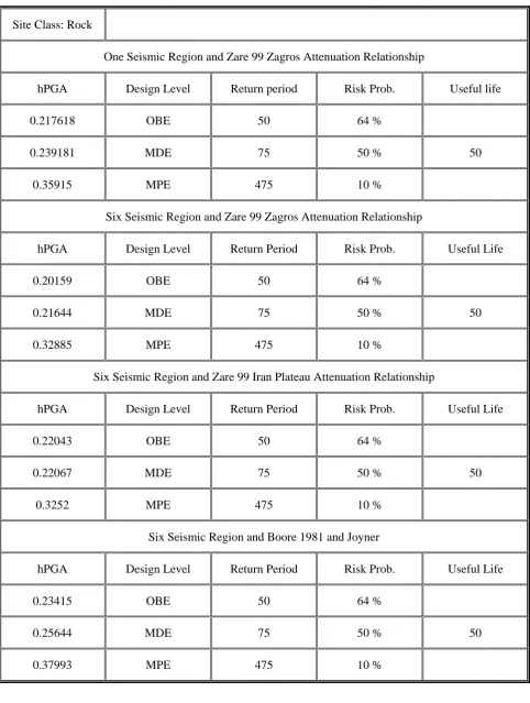
Gachsaran is located in southern parts of Iran along the Zagrous mountain Range. Figure 2 shows seismicity of the city by indicating the study radius. According to hazard study, results of peak ground accelerations are provided in Table 1 Nateghi,et al [2]. It was concluded that the city is potentially located in high to moderate seismic zone causing concerns for the city officials.
3. EVALUATION FORM
An evaluation form was derived for gathering the
buildings information throughout the city. A quick study of literature revealed many forms and recommendations for rapid visual screening techniques. In this study ATC, FEMA, Canadian Forms, Yugoslav Forms and Iranian Forms were studied. Based on these forms and construction techniques used in the regions, a simple form was devised. Main questions in these forms consisted of; general information, structural types and deficiencies, soil conditions, number of building stories, pounding possibilities and irregularities as well as questions concerning disaster management plans. Numbering techniques was used for the evaluation. These values were selected from FEMA recommendations also were calibrated to the local conditions as shown in the form.
4. DATA COLLECTION
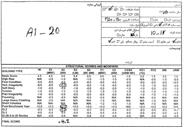
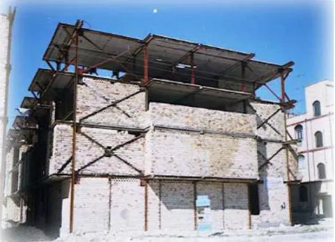
A team of 12 college students ( local civil Eng, dept.) were selected and trained for the data collection. Two team leaders; graduate earthquake engineering students were selected for training and data processing. Two workshops were conducted for training. City was divided into grids and students were sent to different grids. A form was filled out by the students in accordance to the directions given in the workshops for each building. At the end of each day, the forms were collected and the information were placed in a data bank. To minimize personal judgment errors, all gathered data was checked before placing into the bank. A typical filled out form for a typical building of Figure 3 is shown in Figure 4.
IJE Transactions B: Applications Vol. 21, No. 4, December 2008 -
339
Figure 1. Location of city of gachsaran.Figure 2. Seismicity of gachsaran.
5. DEVELOPMENT OF VULNERABLITY AND DISASTER MANAGEMENT
PLANNING MAPS
After collecting more than 10,000 data forms and creating a data bank, the information gathered was applied to generate the vulnerability and disaster management planning maps. Three levels of vulnerability were defined namely, red, yellow and green indicating high (very vulnerable), mediom
TABLE 1. PGA Calculations for the City.
Site Class: Rock
One Seismic Region and Zare 99 Zagros Attenuation Relationship
hPGA Design Level Return period Risk Prob. Useful life
0.217618 OBE 50 64 %
0.239181 MDE 75 50 % 50
0.35915 MPE 475 10 %
Six Seismic Region and Zare 99 Zagros Attenuation Relationship
hPGA Design Level Return Period Risk Prob. Useful Life
0.20159 OBE 50 64 %
0.21644 MDE 75 50 % 50
0.32885 MPE 475 10 %
Six Seismic Region and Zare 99 Iran Plateau Attenuation Relationship
hPGA Design Level Return Period Risk Prob. Useful Life
0.22043 OBE 50 64 %
0.22067 MDE 75 50 % 50
0.3252 MPE 475 10 %
Six Seismic Region and Boore 1981 and Joyner
hPGA Design Level Return Period Risk Prob. Useful Life
0.23415 OBE 50 64 %
0.25644 MDE 75 50 % 50
IJE Transactions B: Applications Vol. 21, No. 4, December 2008 -
341
Figure 3. Typical building subjected to evaluation form.Figure 4. Typical form filled out at the site.
Figure 6. Torsion due to different stiffness around the building.
Figure 7. Soft story due to elimination of bracing in first story.
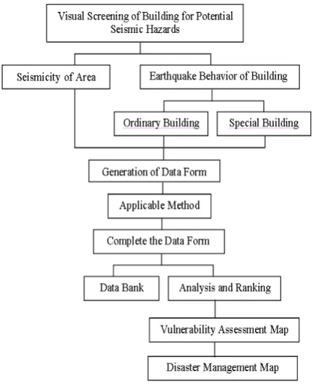
As shown, different locations are specified for different plans such as temporary shelter and so on. Methodology and scope of the work are illustrated in Figure 8.
6. CONCLUSIONS
A city with 15,000 buildings has been evaluated for potential seismic hazard, using simple evaluation technique by the help of 12 college students. This
IJE Transactions B: Applications Vol. 21, No. 4, December 2008 -
343
TABLE 2. Construction Inventory of the City of the Gachsaran.Masonry Masonry Masonry Frame Frame Struc. Typ. Stone Tile Conc. Block R/C Braced Tot. No. Safe 96 1267 813 296 968 36440 % Safe 7.95 39.98 20.00 89.97 50.00 32.13 Vulnerable 1112 1902 3252 33 968 7267 % Vulnerable 92.05 60.02 80.00 10.03 50.00 67.87 Total 1208 3196 4065 329 1936 10707 Total Percent 11.28 29.60 37.97 3.07 18.08 100
Figure 8. Scope of the work.
7. REFERENCES
1. Dehghani, A. and Nateghi, F., “Development of Seismic Vulnerability Maps”, Final Report No. 101/02, Tehran, Iran, (2004).
2. Nateghi, F., “Damage Potentials in City of Yasuj”, Final Report Presented to the Ministry of Housing, Kohgheloyeh va Bouyer Ahmad Province, Tehran, Iran, (2004).
Figure 9. Construction qualities and vulnerability in city of gachsaran.
Figure 10. Proposed disaster management planning map for city of gachsaran.
Iranian Buildings”, 7th Civil Engineering International
Conference, ICCE 2006, Iran, Paper No. E1286 (2006).
4. Zuccaro, G. and Papa, F., “Method of Seismic Vulnerability and Exposure Assessment at National Scale-The Italian Case”, 12th European Conference on
Earthquake Engineering, Paper No. 698, (2006).