A new simplified vector-based model to
support solar energy planning at
urban scale
Liao Wei
Robinson College
University of Cambridge
Date of Submission: 7
thAugust, 2019
This dissertation is submitted for the degree ofThis thesis is the result of my own work and includes nothing which is the outcome of work
done in collaboration except as declared in the Preface and specified in the text. It is not
substantially the same as any that I have submitted, or, is being concurrently submitted for a
degree or diploma or other qualification at the University of Cambridge or any other University
or similar institution except as declared in the Preface and specified in the text. I further state
that no substantial part of my thesis has already been submitted, or, is being concurrently
submitted for any such degree, diploma or other qualification at the University of Cambridge
or any other University or similar institution except as declared in the Preface and specified in
the text. It does not exceed the prescribed word limit for the relevant Degree Committee.
W. Liao
i
Abstract
Dissertation title: A new simplified vector-based model to support solar energy planning at urban scale
Wei Liao
Evaluation of solar potential is a necessary step for integrating solar technologies in
buildings in order to properly assess the benefits of harvesting solar energy and draw
well-informed decisions in various design phases. Solar energy planning at urban scale requires
large-scale solar analysis to support various decision-making contexts, such as making urban
solar targets, prioritizing urban zones or buildings for solar integration, and optimizing solar
technologies tailored for targeting buildings. Existing tools have the following major limitations
to support such decision-making situations. (1) Current advanced simulation models based on
ray trace and ray interception techniques are not effectively scalable to evaluate solar potential
at urban scale due to the expensive modelling process and computational cost. (2) Simple and
statistical models developed for large-scale analysis are not suitable to accurately predict solar
irradiance on individual surfaces with proper consideration of urban shading and reflection.
This dissertation addresses the need for developing scalable, efficient analysis methods to
support the solar energy planning process.
This dissertation has developed a simplified vector-based model that effectively predicts
the solar potential of urban areas on the basis of consideration of the urban context. The
proposed model is based on vector-based methods without the use of ray trace and ray
interception techniques, and consists of new methods that suitably account for the non-uniform
solar radiation of the sky, obstruction by urban surfaces, and reflection by urban surfaces in
urban areas. The proposed model establishes three new methods to simplify the calculation in
the context of urban applications: (1) a two-segment discretisation model, (2) an edge-angle
ii
This dissertation demonstrates the usability of the new model in supporting
decision-making in the solar energy planning process. It addresses the following two hypotheses to
examine the usability of the new model: (1) Simplified, vector-based model, tailored to urban
applications, predict accurate solar radiation on urban surfaces to effectively support
urban-scale analysis and (2) solar analysis with full representation of urban surroundings is necessary
in the calculation of urban shading and solar reflection to correctly support distributed PV
planning.
For the first hypothesis, the performance of the method is compared against the advanced
daylight simulation program RADIANCE and measurements obtained from controlled
experiments. The first comparison demonstrates the new method provides flexible setting
options for different resolution and prediction accuracy requirements and generates reasonably
accurate predictions. The second comparison further confirms the prediction accuracy against
the measurements for the horizontal and vertical surfaces under different shading and reflection
conditions. The comparison with the ray interception approach demonstrates the computational
efficiency of the proposed obstruction model for solar analysis that substantially reduces
calculation iterations for detecting sky and building obstructions. For the second hypothesis,
predictions and decisions derived by the developed method are compared against those by a
lower fidelity models to investigate the importance of modelling urban shading and reflection
with full representation of urban surroundings in three decision making contexts of urban-scale
distributed PV planning process. Additionally, the second hypothesis is furthered examined and
highlighted by investigating the effect of an additional dynamic PV model on decision-makings
in comparison with the effect of the proposed high-fidelity solar radiation model for urban
shading and solar reflection. The new model is demonstrated to enable cost-efficient solar
potential analysis based on urban contexts for supporting solar energy planning at urban scale.
iii
Preface
I remember the greyness in the sky every time when I travelled back home in China for a
vacation. Looking down from the plane, it was like a thin sheet covering the cities, the towns
or even the remote mountains and rice fields. There was not much detail to see from the plane,
not because of the distance, but the air pollution hunting over the land. As someone who grew
up in the southern part of the country, memory with the sky was not like that when I was little.
After 30 years of continuous success of economic development, China transformed from a poor
and underdeveloped country to an economic giant today. Life nowadays is much better for the
people, but not so much for the air we breathe in. In fact, the air pollution has gotten so bad in
the northern part of the country, during the winter season, the pollutions were blown across the
sea all the way to Korea and Japan by the monsoon from Siberia. There started a war, a war
announced against the polluted air, a difficult war to win as more than 70% of the energy
generated in China is coal-based, the dirtiest source of energy knew for a long time. Due to the
political concern of energy safety of an oil-dependent energy system, the Chinese government
is reluctant to expand its gas plants, a relatively cleaner source of energy compared with
coal-based plants, and has no choice but turn to renewable energy.
Under such background, I began my story of studying solar energy and its utilization in
the built environment. During the study in my master course, I was lucky to participate in a
project funded by the National Nature Foundation of China, where I studied the benefits and
challenges of integrating semi-transparent PV on building facades. As it is important to
understand how solar energy can be utilised on the building level, I soon realised it is not enough.
Solar technologies should not be some fancy showcases on some fancy hi-tech looking
architecture. If we ever want to win the war against air pollution, it needs to be applied in a
much larger scale with a lot more people to participate to embrace this renewable energy. The
iv
environment and future development. One key task to promote solar energy utilisation in urban
buildings is to know how the solar resource is first distributed in our cities. And I found a
research gap in the methods for properly and efficiently predict solar energy on such large-scale,
I perused a further answer in my PhD course. I chased after the question of how we can better,
more efficiently deliver a solar potential evaluation at urban-scale. The methods and tools I
established in the study is an attempt to contribute a small but crucial part of what could help
us to better fight in the environmental war against air pollution and energy crisis.
Lastly, I declare that this dissertation is my own work and contains nothing which is the
outcome of work done in collaboration with others, except as specified in the text and
acknowledgements. The work in this dissertation is not substantially the same as any that I have
submitted, or, is being concurrently submitted for a degree or diploma or other qualification at
the University of Cambridge or any other University or similar institution except as declared in
the Preface and specified in the text. I further state that no substantial part of my dissertation
has already been submitted, or, is being concurrently submitted for any such degree, diploma
or other qualification at the University of Cambridge or any other University or similar
institution except as declared in the Preface and specified in the text. The dissertation does not
exceed the prescribed word limit for the relevant Degree Committee.
v
Acknowledgements
The dissertation only becomes reality with the firm support and generous help from many
individuals and from the funding bodies. I would like to express and extend my gratitude as
follows.
I am ineffably indebted to my supervisor Dr. Yeonsook Heo, for her most valuable
guidance and patience throughout my entire course. Her insightful advice and comments on the
research project have been greatly inspirational, and in fact essential to the completion of the
dissertation.
I am greatly thankful to Dr. Shen Xu and his research team. Field experiments would not
be possible without their full supports in providing the required funding and human resources.
I would like to express my gratitude to all of the members of the team, especially to Jianghua
Wang, Zhaojian Wang, Zihao Zhang for their valuable time and efforts during the experiment.
I would also like to thank my colleagues in the research group of Behaviour and Building
Performance (BBP). It has been a great pleasure working with them and learning from them
through accessing and discussing a wide range of research topics in the group.
The research project would not be possible without the funding granted by the Cambridge
Trust and the Chinese Scholarship Council. I thank them for this once of a lifetime opportunity
to study at the University of Cambridge.
Last but not least, I want to thank all of my families and friends for their unconditional
love and supports.
vi
Table of contents
ABSTRACT I
PREFACE III
ACKNOWLEDGEMENTS V
TABLE OF CONTENTS VI
NOMENCLATURE VIII
CHAPTER 1:INTRODUCTION -1
-1.1 Solar energy planning at urban scale 1
-1.2 Current methods for urban-scale solar potential analysis 4
-1.3 Research objectives and methodology 8
-1.4 Structure of the dissertation 10
-CHAPTER 2:A SIMPLIFIED VECTOR-BASED MODEL FOR URBAN-SCALE IRRADIANCE PREDICTION-12
-2.1 Current approaches for modelling urban contexts in solar analysis 13
-2.1.1 Classic approach - 13 -
2.1.2 Statistical model-based approach - 14 -
2.1.3 2.5D raster/pixel-based approach - 15 -
2.1.4 Urban canyon-based approach - 17 -
2.1.5 3-dimensional vector-based approach - 19 -
2.1.6 Current simulation software - 22 -
2.2 Main features of the proposed models 24
-2.2.1 Sky discretisation model - 26 -
2.2.1.1 Current standard model 26
-2.2.1.2 Proposed model 29
-2.2.2 Obstruction model - 37 -
2.2.2.1 Current standard model 37
-2.2.2.2 Proposed model 38
-2.2.3 Reflection model - 40 -
2.2.3.1 Standard model 40
-2.2.3.2 Proposed model 41
-2.3 Surface subdivisions 44
-2.4 Implementation 45
-2.5 Summary 47
-CHAPTER 3:MODEL VALIDATION -48
-3.1 Model validation framework 48
-3.2 The studied urban area 49
-3.3 Comparison against RADIANCE 50
-3.3.1 Effect of model setting parameters - 51 -
3.3.2 Results - 53 -
-vii
3.4.1 General design - 56 -
3.4.2 Construction of the physical urban geometry - 59 -
3.4.3 Weather measurements - 63 -
3.4.4 Measurements uncertainty - 65 -
3.4.5 Impact of parameter uncertainty on the prediction - 66 -
3.4.6 Results - 68 -
3.5 Computational efficiency 74
-3.6 Summary 76
-CHAPTER 4:RELEVANCE OF THE NEW MODEL IN THE URBAN SOLAR ENERGY PLANNING PROCESS -78
-4.1 Introduction 78
-4.2 Urban distributed PV planning process 81
-4.2.1 Political phase - 82 -
4.2.2 Urban design phase - 83 -
4.2.3 Building design phase - 84 -
4.2.4 Summary of decision-making contexts selected for analysis - 85 -
4.3 Radiation prediction model 87
-4.3.1 Classic model - 87 -
4.3.2 Canyon-based model - 88 -
4.3.3 High-fidelity vector-based model - 89 -
4.4 PV system model 90
-4.4.1 Static PV model - 90 -
4.4.2 Dynamic PV model - 92 -
4.4.2.1 Physics-based methods 93
-4.4.2.2 Statistical models 96
-4.4.3 Comparison among different PV cell temperature models - 97 -
4.5 Comparison in decision-making contexts 106
-4.5.1 Selected models for comparisons - 106 -
4.5.2 Examination of radiation prediction models - 108 -
4.5.2.1 Solar targets: maximum PV potential 108
-4.5.2.2 Place-making 110
-4.5.2.3 Economic assessment 113
-4.5.3 Examination of PV models - 116 -
4.5.3.1 Solar targets: maximum solar potential 116
-4.5.3.2 Place-making 117
-4.5.3.3 Economic assessment 118
-4.6 Summary 119
-CHAPTER 5:CONCLUSIONS AND FUTURE WORK -121
-5.1 Summary and conclusions 121
-5.2 Future research 124
-REFERENCE -126
-viii
Nomenclature
BES building edge subdivision
BVA solid angle of building view GVA solid angle of ground view
SVA sky view angle
SVF sky view factor
SHS sky horizontal subdivision
SIS strip inside subdivision
SRSS sky radiance sampling subdivision
UHA urban horizontal angle
avg average
B building
diff diffuse
dh diffuse horizontal
G irradiance (W/m2)
g ground
K number of SIS
low lower boundary of sky patch (rad)
M number of SRSS
N number of SHS
norm normal
R radiance (W. sr/m2)
up upper boundary of sky patch
𝛽 altitude of lowest blocked point (rad)
𝜌 average reflectance
𝜎 angle between surface normal and a line (rad)
𝜙 altitude of sky patch (rad)
𝜉 altitude of highest blocked point (rad)
γ
angle of plane slopedCHAPTER 1: INTRODUCTION
- 1 -
Chapter 1: Introduction
1.1
Solar energy planning at urban scale
Solar energy has been well recognised as a clean and almost inexhaustible energy. With
the improvement of solar technology, continuously decreasing costs and increasing acceptance
by the public, it has been considered as one of the most promising energy sources. Different
solar technologies, including BIPV (building integrated photovoltaic), solar thermal collector
(STC) and other solar design strategies in buildings, have been increasingly adopted by
architects, developers, city planners and authorities as the way to provide clean energy and
therefore reduce the demands of traditional fossil fuels.
Through solar technologies, direct radiation from the sun, diffuse radiation from the sky
and reflected radiation from surrounding environment reaches solar collectors that transfer the
solar energy into various forms, such as electricity through Photovoltaics (PV) (Tripathi et al.,
2016), hot water through thermal collectors (Dupeyrat et al., 2014), or direct heat source
through passive solar walls (Bansal et al., 1993; Stritih and Novak, 1996; O’Hegarty et al.,
CHAPTER 1: INTRODUCTION
- 2 -
geological locations due to the diverse climate conditions (e.g. solar positions and paths,
cloudiness, air mass) (Besharat, et al., 2013). Built environments also play an important role in
creating shading on solar systems due to the surroundings, particularly when an intended solar
application area is located in urban areas (Cheng et al., 2006). The available solar energy
received on the surfaces of interests, such as building roofs or facades, can be referred to as
solar potential (Cheng et al., 2006). Other names such as solar availability or daylight
availability are also commonly used in different studies to evaluate the usability of solar energy
in buildings (Compagnon, 2004; Chatzipoulka, et al., 2016). Assessment of available solar
energy forms a foundation for successful solar applications as it provides key information about
possible energy yields for solar projects.
Evaluation of the the solar potential of urban surfaces is an important step in solar energy
planning. Kanters and Wall (2016) comprehensively identified five different design phases for
solar energy planning in urban environments: political phase, urban design phase, building
design (new buildings) and renovation (existing buildings) phase, implementation and
monitoring phase. The political phase where the solar potential of urban surfaces at a large scale
is evaluated to inform policy-making and strategic plans for setting and achieving a solar target.
For example, Byrd et al. (2013) investigated the maximum PV potential in areas located in the
central business district (CBD) and low-density suburbs in Auckland, New Zealand. The study
designed the energy generation capacity on the basis of the solar analysis that contributes to
reducing the electricity load of a city, supplying energy for a mixture of building types and the
charging of electric vehicles, and reducing peak electricity demand. The next level is the urban
phase where the key task is “place-making: creating a vision for an area and then deploying the
skills and resources to realise that vision” (Yeang, 2000). Solar potential analysis can inform
urban designers by evaluating the effect of restrictions on variables such as maximum building
height and density, extent of impervious surface and open space, and land use types and
activities (Montavon, 2010). Furthermore, it is also used to identify the most potential areas for
solar applications by providing solar maps of each building or block in an urban area for
CHAPTER 1: INTRODUCTION
- 3 -
building design and renovation phases, performance-based design (Lewis, 2014) for sustainable
buildings requires a detailed analysis of the performance and economic assessment of the
designed buildings. In this phase, for example, developers and building owners decide their
investment in PV systems on the basis of the payback time of the PV investment given the
evaluated solar potential (BRE, 2016; Kessler; 2017; Ingrams, 2018; ), and therefore a detailed
model of PV systems have been added to the solar radiation prediction model to support
investment decisions (Paul et al., 2010). Kanters and Wall (2016) pointed out that different
levels of tools are necessary to provide useful information in different design phases. They also
highlighted that the level of detail in the analysis model required for design phases increases as
the design process goes from top (e.g., political phase and urban phase) to bottom (e.g.,
individual building and implementation phase).
Specifically, the rise of distributed PV planning in urban areas places an urgent demand
for proper evaluation of solar potential at urban scale. Different from a traditional and
centralised PV plant in a remote location without the interference of urban shading, urban
distributed PV, as the name suggests, integrate PV systems in individual buildings distributed
in a complex urban environment. On one hand, the advantage of the distributed PV system in
urban areas is that it provides energy directly in the buildings where energy is consumed. As a
result, it reduces the need for extending infrastructure to transmit PV yield through long
distances to consumers and avoids line losses of electricity during distribution. Besides, the
distributed PV system can be grid-connected to sell the excess PV yield to the city grid as part
of the urban energy system, and thus reduces the need of investing an energy storage system
individually in individual buildings. On the other hand, however, urban distributed PV planning
requires solar potential analysis of individual buildings across a large urban area where they
suffer substantial PV yield losses due to urban shading from the surrounding buildings, and
therefore requires careful assessment of potential PV yield with consideration of the urban
context to draw well-inform design decisions. For example, urban solar maps have been used
to assist in selecting locations with high solar availability for PV installation by providing
CHAPTER 1: INTRODUCTION
- 4 -
reduction (Berlin Solar Atlas, 2018; Mapdwell, 2018; Solarkataster, 2018). Some researchers
further incorporated additional parameters, such as historical urban data including building
types and ages for a comprehensive evaluation of solar applications in urban environment
(Amado and Poggi, 2014; Berlin Environment Atlas, 2018). Researchers have also explored the
electricity network compatibility to adopt the predicted PV yield electricity in urban areas. Wall
(2012) generated hourly and monthly PV yield predictions and coupled them with three
different distribution grids at one planned urban area in Sweden to identify the maximum PV
hosting capacity and accordingly the resulting overload capacity given a maximum PV yield
potential in the urban area. These studies above have demonstrated the importance of solar
analyses at urban scale in evaluating solar projects for a large audience of planners, developers
and property owners in terms of economic and environmental benefits.
1.2
Current methods for urban-scale solar potential analysis
Several research studies have attempted to derive generic relationships between urban
morphology and solar potential through statistical analyses. Mohajeri et al. (2016) characterised
the urban morphology in terms of compactness measures, including site coverage, plot ratio,
and building density, and found the received solar radiation in the tested urban area is strongly
correlated with its distance to the dense city centre, and with the average building height in that
urban area. The author also confirmed various correlation coefficient between the yield of
different active and passive solar applications in relation to urban compactness. The research
provides general guidelines for evaluating the solar potential of large urban areas; for example,
solar irradiance differs up to 30%–40% depending on the compactness of an urban area, and
annual solar irradiation in the suburban area is generally 10–15% higher than that in the city
centre. However, this level of information is not sufficient to support a wide range of design
and planning projects for other cities nor provides the detailed information needed to identify a
group of building areas with the maximum solar potential within the urban area and optimise
the design of solar systems for the identified areas. Another study carried by Sarralde et al.
(2015) used an extensive set of urban form parameters (18 parameters) to capture variability in
CHAPTER 1: INTRODUCTION
- 5 -
urban morphology and the solar potential of the neighbourhood. However, this study provides
aggregated-level information about the correlation between the overall urban morphology and
the solar potential of the entire neighbourhood. This level of information may be useful if the
same design strategies are applied to all the buildings in the neighbourhood area, but it is not
sufficient to prioritise buildings for solar integration, nor tailor the design of solar technologies
for individual buildings.
Another approach for urban-scale solar analysis is to perform a simulation of solar
irradiance by using urban fabric as an input, to generate the outcomes of solar potential for a
specific urban case in the decision-making process. Different types of models and methods have
been developed for predicting solar potential. In terms of how the urban context is considered
in the model, they can be grouped into classic models, historical satellite data, canyon-based
models, 2.5D raster-based models, and 3D-vector-based models.
Classic approaches (Besharat et al., 2013; Fortin et al., 2008; Freitas et al., 2008) that
ignore urban shading and solar reflection from surrounding buildings have been long used for
a quick estimation of PV yield on roofs where usually shading and reflection is less significant
than those on walls. Historical satellite data have been used to provide annual or monthly
predictions of available solar energy at different locations (Sabbagh et al., 1977; Tarpley, 1979;
Cano et al., 1986; Gueymard et al., 2011). This approach, however, does not provide predictions
of solar energy on vertical surfaces. The low spatial resolution of satellite data is also an issue
because it prohibits the proper distinction of individual surfaces in urban areas.
Some models are based on a simplified urban representation to consider urban shading
and solar reflection. For example, canyon-based approaches (Arnfield, 1990; Robinson and
Stone, 2004; Bozonnet et al., 2005) are based on the urban canyon concept that assumes that
buildings that contribute to radiation obstruction and reflection have the same height without
skyline variation. They only consider the surrounding buildings within the canyon while
CHAPTER 1: INTRODUCTION
- 6 -
approaches (Redweik et al., 2013; Lindberg et al., 2015) are based on actual urban footprints
with varying building heights for the representation of dynamic skyline obstruction. However,
due to the 2.5 D representation of an urban geometry, vertical surfaces such as walls and façades
are defined as binary pixel points. Therefore, an additional process is required with additional
hyperpoints assigned within each pixel to represent different height positions for the
determination of daylight obstruction at each hyperpoint. As a result, the process for calculating
shadings on walls/façades is fairly complicated and fundamentally requires computationally
expensive ray-interception algorithms to aid the process, and calculating reflection from
surrounding buildings is not possible.
3D-vector-based approach is based on a full representation of surrounding buildings and
allows for an accurate reflection of urban shading and solar reflection in a unified manner as
3D points with vector information (i.e., knowing the facing direction) do not need to be
pre-classified and can be passed on for calculating daylight obstruction and reflection in the exact
same manner. For instance, the advanced daylight simulation tool RADIANCE (Ward, 1994),
uses an urban geometry model in a complete 3D format with information of surface vectors and
uses computational techniques such as ray tracing or ray interception for complex calculation
of detailed obstruction and reflection.
However, current vector-based, high-fidelity models, especially the ones relying on
ray-based algorithms, tend to be expensive in terms of modelling and computational costs. A
simplified radiosity algorithm was developed by Robinson and Stone (2004) to improve
computational efficiency for solar analysis in urban contexts. However, even after the
implementation of simplifications to these methods, they are fundamentally based on
ray-tracing or ray intercept algorithm with a complex sky discretization model, and consequently
tend to result in heavy computational burdens for detecting obstruction and calculating
reflections among building and ground surfaces. Furthermore, detailed data on individual
surface properties are typically unavailable for urban-scale solar analyses. Given the scale of
CHAPTER 1: INTRODUCTION
- 7 -
building envelope details (e.g., balcony, windows and parapets) and associated surface
properties. Even if all surface albedos are set to the same values in RADIANCE, for example,
the calculation process is still the same as that for the case with different albedos. Setting the
same albedo for all surfaces does not reduce the computational cost of RADIANCE. Hence,
there is room for developing a simplified method tailored to urban applications with typically
available urban data.
Therefore, two major limitations regarding the current methods at delivering solar
potential at urban scale are identified as follows:
(1) Current advanced simulation models based on ray trace and ray interception
techniques are not effectively scalable to evaluate solar potential at urban scale due to
the expensive modelling process and computational cost.
(2) Simple and statistical models developed for large-scale analysis are not suitable to
accurately predict solar irradiance on individual surfaces with proper consideration of
urban shading and reflection.
The two identified research gaps place a significant obstacle to accurately and efficiently
delivering a solar potential analysis at urban scale in aid of urban solar energy planning. For
the political decision-making phase that often requires solar potential at national or regional
scale, one of the key interests is the total amount of solar yield at large scale rather than
individual building scale. The current advanced simulation models could not properly scale up
to urban level due to high computational and modelling cost, while simple methods could not
properly consider urban shading and reflection and lead to inaccurate predictions. The same
problem occurs in urban design phases where prioritizing buildings/areas for solar integration
requires solar potential evaluation on all individual buildings in the planned urban area. Hence,
there is a need for new analysis methods tailored to aid solar energy planning at urban scale to
CHAPTER 1: INTRODUCTION
- 8 -
1.3
Research objectives and methodology
The objective of this dissertation is to develop a new model for solar potential analysis
that can effectively support solar energy planning at urban scale. To overcome the limitations
of current methods, the new method achieves the following major features:
It is a solar analysis model tailored for urban applications with consideration of
the urban context.
It does not require any ray tracing or ray interception.
It provides easy and flexible setting options for different levels of required
accuracy.
The dissertation proposes a simplified vector-based model without the use of ray trace and
ray interception techniques, yet consists of new methods that suitably account for the
nonuniform solar radiation of the sky, obstruction by urban surfaces, and reflection by urban
surfaces. Three new model components are created to simplify the simulation process: (1) a
two-segment discretisation model, (2) an edge angle detection obstruction model, and (3) a
unified view-angle-based reflection model. Unlike the commonly used current simulation
models developed to suit the various daylight applications, the simplified method is developed
specifically to reflect the context of urban-scale solar analysis, which potentially reduce the
computational cost to effectively support large-scale analyses, while achieving the prediction
accuracy required for the solar applications. Furthermore, the proposed method is designed to
provide easy and flexible setting options for different resolution and prediction accuracy
requirements.
This dissertation demonstrates the feasibility of the new model in supporting
decision-making in the solar energy planning process. It addresses the following two hypotheses to
CHAPTER 1: INTRODUCTION
- 9 -
Simplified, vector-based model, tailored to urban applications, predicts accurate solar
radiation on urban surfaces to effectively support urban-scale analysis.
Solar analysis with full representation of urban surroundings is necessary in the
calculation of urban shading and solar reflection to correctly support distributed PV
planning.
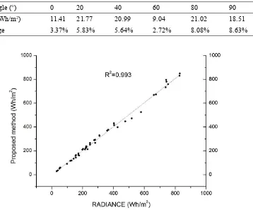
The first hypothesis is examined by evaluating the model performance of the proposed
model. First, the study compares the predictions of the developed method against the advanced
daylight simulation program RADIANCE and measurements obtained from controlled
experiments through a case study of an urban area located in Wuhan, China. Before
comparisons, different configurations and settings of the developed method are first tested for
achieving a good balance between prediction accuracy and computational efficiency. The first
comparison evaluates the prediction accuracy of the new model against RADIANCE. The
second comparison against controlled experiment measurement further tests the accuracy of the
new model to predict solar radiation in a real physical environment. Next, the computational
efficiency of the new method for detecting surrounding solar obstructions is tested against the
current ray-based algorithm.
The second hypothesis is examined by comparing predictions and decisions by the
developed method with those of a lower fidelity models to investigate the importance of
modelling urban shading and reflection with full representation of urban surroundings. Three
decision-making contexts are considered in an urban-scale distributed PV planning process.
Additionally, the hypothesis is furthered examined and highlighted by investigating the effect
of an additional dynamic PV model on decision-making in comparison with the effect of the
CHAPTER 1: INTRODUCTION
- 10 -
1.4
Structure of the dissertation
The research outline is illustrated in Figure 1 with the following chapters presented in the
dissertation.
Chapter 1 presents motivations for solar potential analysis in aid of solar energy
planning at urban scale, summarises the limitations of current methods, and proposes a
new method that can support solar energy planning at urban scale.
Chapter 2 presents a simplified vector-based model tailored to solar irradiance
prediction in an urban context in comparison to current standard models with limited
capabilities for urban-scale solar analysis.
Chapter 3 validates the developed model by comparing the performance of the developed
method against the advanced daylight simulation program RADIANCE and
measurements obtained from controlled experiments. The computational efficiency of
the proposed method of detecting surrounding solar obstructions is tested against the
standard ray-based algorithm.
Chapter 4 demonstrates and examines the usability of the proposed method by
examining the relevance of the two key modelling features associated with solar
potential evaluation in the solar energy planning process.
CHAPTER 1: INTRODUCTION
- 11 -
CHAPTER 2: A SIMPLIFIED VECTOR-BASED MODEL FOR URBAN-SCALE IRRADIANCE PREDICTION
- 12 -
Chapter 2: A simplified vector-based model for
urban-scale irradiance prediction
This chapter presents a new modelling approach for solar potential prediction at
urban-scale. This chapter first summarises the current methods and tools used for the analysis of solar
potential at urban scale. A key part in solar analysis for urban applications is how complex
urban surroundings are represented for the prediction of shading and solar reflection among
urban surfaces. Based on the literature review, the current methods were grouped into five
categories, mainly in terms of the spatial dimensions of the urban geometry considered for
predicting urban shading and reflection. Then, the chapter summarises the key model
components for irradiance prediction at urban scale: sky discretisation model, obstruction
model and reflection model. The limitations of the standard models used for urban applications
were identified, and a simplified vector-based model was developed to effectively predict solar
CHAPTER 2: A SIMPLIFIED VECTOR-BASED MODEL FOR URBAN-SCALE IRRADIANCE PREDICTION
- 13 -
2.1
Current approaches for modelling urban contexts in solar analysis
2.1.1
Classic approach
Classic approaches (Bugler, 1977; Klucher, 1979; Ma and Iqbal, 1983; Hay and McKay,
1985) have been well established and used to estimate global solar radiation on a surface of
interest, typically with the assumption that a building is stand-alone without surrounding
buildings. Without the consideration of urban context, calculating solar radiation on a surface
of interest is straightforward and consists mainly of two steps: calculating the received sunlight
by accumulating hourly direct normal irradiance (i.e., the beam sunlight) on a surface given the
surface tilt angle and corresponding altitude angle and surface-solar azimuth and calculating
the skylight (i.e. diffused irradiance) by estimating the irradiance received from the partly
visible sky dome using a isotropic sky model that assumes all of the diffuse radiation is
uniformly distributed over the complete skydome. Given the fact that the isotropic sky model
is less accurate in weather conditions that are not cloudy and overcast, some researchers (Van
Brink, 1987; Hay and McKay, 1988) explored the use of an anisotropic sky to improve the
prediction accuracy of diffuse irradiance in various weather conditions. Muneer (1997) applied
simple angle calculations given an assumed albedo of the ground surface to calculate irradiance
reflected from the ground for a tilted plane, but this approach assumes the ground is completely
visible to a plane of interest without any obstruction by surrounding urban surfaces.
Given the fact that shading and reflection in urban areas are mainly due to the surrounding
built environment, the basic classic models without any consideration of urban shading can
only provide a very crude estimation of received solar radiation in urban environment. Although
classic approaches do not account for shading and reflection from surrounding buildings in
urban contexts, efforts (Dubayah and Rich,1995; Hofierka and Suri, 2002) have been made to
extend the capability of classic models to account for large-scale terrain obstruction such as
obstruction from the surrounding mountains represented by GIS-based digital elevation models
(DEM). These approaches calculate the obstructed part of sky diffuse irradiance by using the
concept of sky view factor (SVF) (i.e., the fraction of visible sky to entire skydome). The
CHAPTER 2: A SIMPLIFIED VECTOR-BASED MODEL FOR URBAN-SCALE IRRADIANCE PREDICTION
- 14 -
radiation in an open field in mountainous regions. However, given the fact that shading and
reflection in urban areas are mainly due to the surrounding built environment, the improved
classic models are still not sufficient to predict radiation in urban contexts.
2.1.2
Statistical model-based approach
Historical satellite data have been used to provide annual or monthly predictions of
available solar energy at different locations (Sabbagh et al., 1977; Tarpley, 1979; Cano et al.,
1986; Gueymard et al., 2011). In this approach, predictions of solar energy on vertical surfaces
are not available. The low spatial resolution of satellite data is also an issue because it prohibits
proper distinction of individual surfaces in urban areas. Typically, meteorological solar
radiation data have been used in large-scale solar analyses in the form of a constant hourly
irradiance value across the entire city, without consideration of mutual shading among
neighbouring buildings. A modified and improved version of the constant approach, PVWatts,
was developed by the National Renewable Energy Laboratory (NREL) to calculate the monthly
average daily total insolation (sun and sky) on a horizontal surface on the basis of a 40 km
square-grid of a typical meteorological year (TMY) dataset for the entire United States (Marion
et al., 2001). Although this method accounts for PV panel tilted angle, orientation, and
meteorological air temperature in the calculation of energy production, nevertheless, it ignores
the shading and reflection effect of the urban context on the solar energy distributed over the
urban area.
Meanwhile, existing studies have explored surrogate-model-based approaches based on
historical data. Several research papers applied artificial neural networks (ANNs) as a new
approach to predict solar irradiance in urban areas (Sözen et al., 2008; Koca et al., 2011; Senkal
and Kuleli, 2009). The ANN models used a location of the urban area (e.g. longitude, latitude
and altitude), time (e.g. year and month) and historical solar measurements (e.g. mean diffuse
radiation and mean beam radiation) as inputs to generate average solar radiation predictions on
the ground or roofs for a specific city. Although prediction results showed good agreement with
CHAPTER 2: A SIMPLIFIED VECTOR-BASED MODEL FOR URBAN-SCALE IRRADIANCE PREDICTION
- 15 -
major limitation. A recent study developed statistical models to provide more location-specific
predictions for building roofs (Karteris et al., 2013). However, the statistical models have
limitations to extend to predict solar irradiance at fine temporal and spatial resolutions,
especially for dense urban areas in which detailed urban morphology needs to be considered as
inputs for prediction.
2.1.3
2.5D raster/pixel-based approach
Raster-based approaches based on digital elevation models (DEMs) have been developed
to represent the urban landscape on a pixelised 2.5D raster grid for solar irradiance prediction.
In these approaches, the solar irradiance received by a target object is calculated by determining
whether an object pixel can be observed from either direct or diffuse sunlight.
Early efforts (Dubayah and Rich,1995; Hofierka and Suri, 2002) in developing
raster-based methods aimed to account for large-scale terrain obstruction such as obstruction from the
surrounding mountains represented by DEMs. In these approaches, whether sunlight is
obstructed for each object pixel is determined through producing a shadow map on the DEM,
and whether diffuse skylight is obstructed for each pixel is determined by using the concept of
sky view factor (SVF) (i.e., the fraction of visible sky to entire skydome). Algorithms for
calculating SVF tailored for large-scale terrains (Dozier et al., 1981) were used to pixelise the
DEM into grid-based points and run a screening process to identify the nearest grid points that
cause the maximum obstruction on each pixel point, which is similar to a radar detecting
potential terrain obstructions. The raster-based approaches, considering terrains for solar
predictions have been used in regional-scale applications such as precision farming (Reuter et
al., 2005), soil moisture studies (Wilson and Gallant, 2000), ecologic assessment (Kumar and
Skidmore, 2000), and Hydrology studies (McVicar et al., 2007). Meanwhile, these raster-based
approaches have been adopted in some of the tools, such as the Solar Analyst (Fu and Rich,
1999), used to generate solar maps of urban areas. The Solar Analyst is integrated within the
ArcGIS environment and has been extensively used to-this-date to generate many solar maps,
CHAPTER 2: A SIMPLIFIED VECTOR-BASED MODEL FOR URBAN-SCALE IRRADIANCE PREDICTION
- 16 -
roofs, without consideration of shading and reflection from surrounding buildings. In general,
models with consideration of shading due to the terrain level lack the ability to calculate detailed
shading by surrounding buildings in urban areas due to their inability of calculating shadow
maps and SVF for every point of urban surfaces. To overcome such limitation, improved
GIS-based methods tailored for urban applications were later developed.
Improved algorithms and methods have been developed to replace traditional raster-based
approaches for urban applications. The latest raster-based methods use digital surface models
(DSM) to accurately represent the effect of the surrounding urban morphology on solar
irradiance on the 2.5D raster grid. Light detection and ranging (LiDAR) technology is now
extensively used to detect objects in urban areas, categorize them into vegetation, ground, and
building façades, and provide associated detailed geometric information that allows the creation
of DSMs that represent the actual urban context in detail. With DSMs as model inputs,
researchers (Lindberg et al., 2015; Redweik et al., 2013) have developed different raster-based
shadow calculation methods to determine the obstruction of solar irradiance on building roofs
and facades owing to surrounding buildings. For instance, the shadow model developed by
Redweik et al. (2013) creates hyperpoints for each pixel in the raster grid and examines whether
each hyperpoint is inside (i.e., obstructed) or outside (i.e., unobstructed) of the shadow cast by
surrounding buildings to predict direct irradiance.
The latest raster-based approaches greatly improve the capability of predicting solar
irradiance on both roofs and facades. However, due to the 2.5 D representation of an urban
geometry, vertical surfaces such as walls and façades are defined as binary pixel points (i.e., 1:
vertical; 0: non-vertical). Therefore, an additional process is required with additional
hyperpoints assigned within each pixel to represent different height positions for the
determination of daylight obstruction at each hyperpoint. As a result, the process for calculating
shadings on walls/façades is fairly complicated, and calculating reflection from surrounding
buildings is not possible. Furthermore, they tend to be computationally expensive for
CHAPTER 2: A SIMPLIFIED VECTOR-BASED MODEL FOR URBAN-SCALE IRRADIANCE PREDICTION
- 17 -
fundamentally requires ray-interception algorithm to aid the process (Figure 2). The creation of
DSMs often relies on LiDAR technology that is usually expensive and not easily accessible.
Indeed, processing data from LiDAR is an intensive process that requires expert skills, thereby
making it difficult to use this technology as part of common practices in the building domain.
The GIS data is another type of available urban data that can be straightforwardly translated
into DSMs for the existing urban infrastructure.
Figure 2. Shadow cast algorithm for obstruction detection aid by ray-interception
algorithm (Liang, et al., 2014)
2.1.4
Urban canyon-based approach
Another type of methods for urban solar analysis is based on the urban canyon concept
that approximates urban geometry under the assumption that the buildings are identical and
regularly distributed in the urban environment. Radiation exchange between surfaces is
calculated under this key assumption that allows for translating 3-dimensional urban
surroundings into a 2-dimensional canyon elevation. One of the earliest models, developed by
Arnfield (1976), is based on canyon geometry and associated surface properties to compute
solar and longwave irradiances. The model computes energy exchanges on a canyon
cross-section and the solar radiation reflected by canyon surfaces is calculated with the assumption
that the reflected radiation is Lambertian (i.e., fully diffused). On the basis of the model,
CHAPTER 2: A SIMPLIFIED VECTOR-BASED MODEL FOR URBAN-SCALE IRRADIANCE PREDICTION
- 18 -
land-use zones within Columbus, Ohio and later assessed the role of canyon geometry on solar
radiation access (Arnfield, 1990). More recently, Robinson and Stone (2004) developed a
canyon-based method in which obstruction from the street across is simplified as a constant
horizontal altitude to reflect urban shading for a view point. An obstructing wall from a view
point is calculated in terms of angles to upper and lower obstructing surfaces normal to the
point of interest for calculating solar irradiance in use with an anisotropic sky model (Figure 3).
Bozonnet et al. (2005) developed a simplified method for calculation of radiant interchange
among urban surfaces by translating a studied zone into a section of an infinite long street
canyon (W/L≪ 1 and H/L≪ 1) as shown in Figure 4.
Figure 3. Canyon elevation for solar calculation. (Robinson and Stone,2004)
Figure 4. Illustration of a common canyon geometry. (Bonzonnet et al., 2005)
The approximation of an urban geometry into street canyon suggested by the studies
mentioned above brings a great advantage in terms of relatively low modelling cost, since it is
much more cost-efficient to derive canyon information such as canyon aspect ratio (e.g., H/W)
CHAPTER 2: A SIMPLIFIED VECTOR-BASED MODEL FOR URBAN-SCALE IRRADIANCE PREDICTION
- 19 -
canyon concept may sufficiently capture the urban geometric characteristics in a “flat” city in
which buildings indeed have similar heights and are regularly distributed along streets, such as
Paris and many of the European cities (Figure 5, left-subfigure). However, the canyon concept
cannot capture a more complex urban landscape (Figure 5, right-subfigure) in which the
distribution of buildings is significantly heterogeneous in terms of building height and shape.
Figure 5. Typical street canyons in a “flat” city (left) in Paris, Europe and “vertical” city in
Hongkong, China (right).
2.1.5
3-dimensional vector-based approach
Three-dimensional vector-based simulation models have the highest-fidelity
representation of complex urban morphology for solar analyses. In these models, physical
objects are modelled individually as vector objects in three dimensions, which gives us great
advantages to accurately compute any angle of solar radiation onto individual surfaces as vector
objects tell us not only where they are located by 3D coordinates but also which direction they
face to by their normal vectors.
Either an isotropic or anisotropic sky model is used in this approach to represent the sky
radiation and calculate the diffuse solar radiation on a test point from the visible sky.
Traditionally, high-fidelity, vector-based simulation software, such as RADIANCE and Daysim,
are commonly used for indoor daylight simulations or image rendering. Daysim (Reinhart and
Breton, 2009), using RADIANCE as the simulation engine, provides an effective workflow
well-tailored for indoor daylight simulations with a more user-friendly interface. More recently,
CHAPTER 2: A SIMPLIFIED VECTOR-BASED MODEL FOR URBAN-SCALE IRRADIANCE PREDICTION
- 20 -
city solar maps (Jakubiec and Reinhart, 2012), or for evaluating and improving solar irradiance
availability for buildings in urban environments (Kämpf et al., 2010). However, vector-based
models used in RADIANCE and Daysim are computationally expensive as they are based on
complex algorithms (e.g., raytracing method) in association with the use of a sky discretisation
model designed to be generally applicable for various daylight applications. Raytracing is
commonly used for detecting light obstruction and reflection. Although forward ray tracing
(Nadal and Moll, 2012) can accurately capture light phenomenon such as refraction and Fresnel
effect, it is very inefficient as it generates many light rays that never reach the final viewpoint.
In addition, as refraction and Fresnel effect is much less significant for daylight assessment in
buildings and urban environments, backward raytracing (Arvo,1986) is more commonly used
in the field. The commonly used daylight simulation software programs, including Daysim, use
backward raytracing with the daylight coefficient method and Perez sky model to perform
indoor daylight simulation for prediction of daylight illuminance and glare. Recently, the hybrid
ray-tracing method that combines the two mentioned methods were introduced (Chan and
Tzempelikos, 2012), but it is nevertheless a naturally heavy and computationally aggressive
approach. Furthermore, detailed information on the surface properties of urban surfaces are
required as model inputs, and may not be attainable for urban-scale applications for which very
limited data exists for individual surface characteristics (e.g., surface reflectance, roughness,
specular reflectance, etc.) in urban areas. Indeed, the urban solar studies described above on the
basis of the simulation model have often used a single value to describe the surface properties
of all building surfaces, and have assumed that all the surfaces in the studied urban area have
the same reflection characteristics. For vector-based approaches, both computational cost and
urban data availability are currently the two key issues for large-scale urban simulation.
Therefore, there is room for developing new models to cope with such issues. It should be noted
that there is a growing effort to collect ground-based and remote-sensed survey data (Romanoni,
et al., 2017; Sun et al., 2012), which can be used to estimate individual surface properties in a
CHAPTER 2: A SIMPLIFIED VECTOR-BASED MODEL FOR URBAN-SCALE IRRADIANCE PREDICTION
- 21 -
Simplifications to the vector-based models have been suggested by researchers to reduce
the computational burden of simulations for urban-scale applications. Erdélyi et al. (2014)
developed a three-dimensional solar radiation model (SORAM) and tested it against
measurements from a real urban area. SORAM ignores reflected irradiance but uses the
high-resolution sky model and ray tracing method to detect obstructions. The accuracy of SORAM
was validated against real measurements, but the computational efficiency of the method for
large-scale urban applications was not discussed. Robinson and Stone (2004) developed a
simplified radiosity algorithm (SRA). In SRA, the reflection model is simplified on the basis
of the assumption that all reflected surfaces are Lambertian. With the use of the Tregenza sky
model, SRA calculates solid angles of each sky patch in relation to a viewpoint to compute
uniform radiance of the sky patch on to the viewpoint. A technique of cumulated sky radiance
is incorporated in SRA, where both hourly direct and diffuse radiance are pre-processed and
computed into one single sky radiance map beforehand in order to reduce the number of
calculation iterations for longer simulation periods (e.g., monthly and annual predictions). SRA
also uses the mathematical technique of matrix inversion to reduce the computational cost for
reflection calculation. The same authors demonstrated that SRA provides accurate predictions
in comparison to RADIANCE. SRA is used in SunTool (Robinson et al., 2007) and CitySim
(Walter and Kämpf, 2015) developed for simulation and optimization of urban sustainability.
Among the existing methods described above, the vector-based simulation methods offer
functionalities that provide accurate predictions for solar analyses. However, even after the
implementation of simplifications to these methods, they are fundamentally based on
ray-tracing or ray intercept algorithm with a complex sky discretisation model and, consequently,
tend to result in heavy computational burdens for detecting obstruction and calculating
reflections among building and ground surfaces. Furthermore, detailed data on individual
surface properties are typically unavailable for urban-scale solar analyses. Given the scale of
solar analysis, it is not possible to obtain a detailed level of information about individual
building geometry and associated surface properties. Even if all surface albedos are set to have
CHAPTER 2: A SIMPLIFIED VECTOR-BASED MODEL FOR URBAN-SCALE IRRADIANCE PREDICTION
- 22 -
for the case with different albedos. Setting the same albedo for all surfaces does not reduce the
computational cost of RADIANCE. Hence, there is room for developing a simplified method
tailored to urban applications with typically available urban data.
2.1.6
Current simulation software
Table 1 lists some of of the software on the basis of different methods discussed above for
solar potential analyses at different design scales. Tools such as Solei-32 and SolarFlux target
regional-scale solar analyses that need to take into consideration geographical features of an
area of interest and, therefore, deploy the basic raster-based models that do not consider
complex urban morphology and resulting urban shading and reflection. Tools such as CitySim
and SORAM are specifically designed for urban-scale simulation and deploy high-fidelity 3D
vector-based models that account for urban shading and reflection. Tools such as RADIANCE
and Daysim are well known for their ability to provide a detailed simulation of indoor daylight
environment in buildings, and require a high level of data inputs for modelling the geometry of
objects in a building and associated surface properties for prediction of daylight distribution
across indoor spaces. For PV system design, PV engineers use tools such as PVSyst to test the
performance of a designed PV plant or designed PV systems on a building, and the tools offer
users an option to consider shading on the designed PV module of interest due to nearby
buildings. Among the software, the ones used for prediction of irradiance on urban surfaces at
urban-scale rely on computationally heavy techniques such as ray-based and shadow-volume
calculation (fundamentally requiring ray-interception). The current simulation software
developed initially for different targeting applications are not suitable to effectively predict
irradiance distributed over urban surfaces with proper consideration of complex urban
CHAPTER 2: A SIMPLIFIED VECTOR-BASED MODEL FOR URBAN-SCALE IRRADIANCE PREDICTION
- 23 - Table 1. Current tools for solar analyses
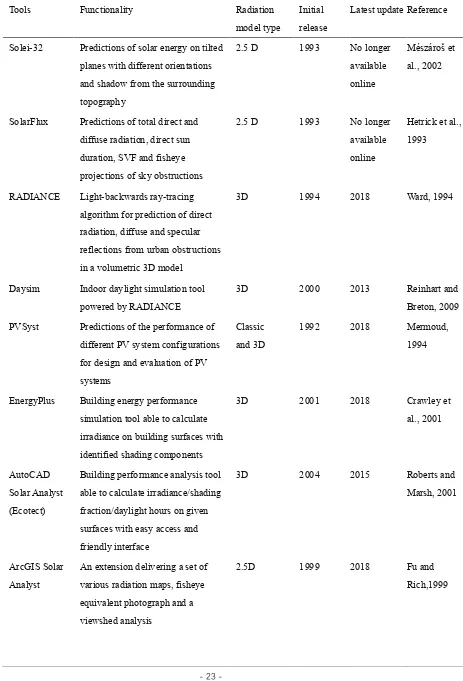
Tools Functionality Radiation model type
Initial release
Latest update Reference
Solei-32 Predictions of solar energy on tilted planes with different orientations and shadow from the surrounding topography
2.5 D 1993 No longer available online
Mészároš et al., 2002
SolarFlux Predictions of total direct and diffuse radiation, direct sun duration, SVF and fisheye projections of sky obstructions
2.5 D 1993 No longer available online
Hetrick et al., 1993
RADIANCE Light-backwards ray-tracing algorithm for prediction of direct radiation, diffuse and specular reflections from urban obstructions in a volumetric 3D model
3D 1994 2018 Ward, 1994
Daysim Indoor daylight simulation tool powered by RADIANCE
3D 2000 2013 Reinhart and
Breton, 2009
PVSyst Predictions of the performance of different PV system configurations for design and evaluation of PV systems
Classic and 3D
1992 2018 Mermoud, 1994
EnergyPlus Building energy performance simulation tool able to calculate irradiance on building surfaces with identified shading components
3D 2001 2018 Crawley et
al., 2001
AutoCAD Solar Analyst (Ecotect)
Building performance analysis tool able to calculate irradiance/shading fraction/daylight hours on given surfaces with easy access and friendly interface
3D 2004 2015 Roberts and
Marsh, 2001
ArcGIS Solar Analyst
An extension delivering a set of various radiation maps, fisheye equivalent photograph and a viewshed analysis
2.5D 1999 2018 Fu and
CHAPTER 2: A SIMPLIFIED VECTOR-BASED MODEL FOR URBAN-SCALE IRRADIANCE PREDICTION
- 24 - Table 1
(continued)
r.sun Irradiance raster maps, reflectance and shadow maps for horizontal or inclined surfaces, fitting to overcast and clear-sky conditions
3D 1997 2013 Hofierka,
2002
DIVA Daylighting and energy modelling plug-in for the Rhinoceros, using the SRA method with ray-tracing technique
3D 2011 2016 Jakubiec,
2011
CitySim Energy simulation tool aiming at urban scale, able to calculated solar irradiance on building surface in a given time period
3D 2011 2015 Walter and Kämpf, 2015
Solar3DBR Google SketchUp plug-in for shading factor and the irradiation determination on surfaces of 3D models
3D 2013 2013 Melo et al., 2013
SORAM (codes)
Predictions of direct and diffuse solar radiation incident on a sloping PV cell in an urban environment using ray-tracing technique
3D Unavailabl e online
Erdélyi et al., 2014
Ladybug and Honeybee
Outdoor and indoor daylight simulation tool powered by RADIANCE
3D 2013 2018 Roudsari et al., 2013
2.2
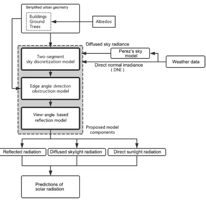
Main features of the proposed models
Based on the identified limitations of current approaches at handling urban shading and
reflection, this dissertation developed a simplified, physics-based method that allows the
efficient modelling of the solar potential in urban areas. The proposed method consists of three
model components: (a) two-segment sky discretisation method, (b) edge-angle-detection
obstruction method, and (c) unified view-angle-based reflection method, as an improved
alternative to the current standard methods. With the reflection of the urban context, the
CHAPTER 2: A SIMPLIFIED VECTOR-BASED MODEL FOR URBAN-SCALE IRRADIANCE PREDICTION
- 25 -
patches required for the prediction of irradiance on urban surfaces. Also, the
edge-angle-detection method together with the view-angle-based reflection method can substantially
reduce the number of iterations in the calculation process. Furthermore, the new method
provides users with flexible control parameter settings related to the analysis setup for various
requirements of prediction accuracy.
Figure 6 shows a process of predicting irradiance in urban areas using the proposed method.
Three-dimensional urban geometry data is a key input to the proposed method. For a long time,
obtaining three-dimensional urban geometry data has been a major obstacle for urban-scale
simulations. Manual creation of an urban model is labour intensive, and model creation based
on LiDAR requires expensive equipment and experts to collect and process the measured data.
Alternatives are the growing databases of 3D urban models. For instance, simplified urban 3D
models for UK cities are available in EDiNA (EDiNA, 2017). The proposed method is able to
take in any 3D vector-based geometry, either processed from LiDAR or GIS or manually
created in tools such as CAD or SketchUp. However, these models only provide geometric
information, but do not provide information on the surface properties of buildings and roads,
such as albedos, that impact reflected solar irradiance. Given that detailed information about
individual urban surfaces will not be accessible in the near future, the proposed method uses
two albedos: one for all buildings, and the other for all the roads. Other important inputs to the
model are weather data, particularly direct normal incident (DNI), global horizontal irradiance
(GHI), and dew point temperature data. These constitute typical weather data such as by TMY2.
The all-weather sky model introduced by Perez et al. (1993; 1987) is used to predict sky diffuse
radiance distributed over the skydome. With simplified urban geometry, surface albedos and
weather data, the proposed model outputs direct sunlight radiation, diffuse skylight radiation,
and irradiance reflected by the surrounding buildings. By accumulating the three outputs, the
total solar irradiance received on any point-of-interest in a testing urban area is thus obtained.
Sections 2.2.1, 2.2.2, and 2.2.3 provide a detailed description of the sky discretisation,
CHAPTER 2: A SIMPLIFIED VECTOR-BASED MODEL FOR URBAN-SCALE IRRADIANCE PREDICTION
- 26 -
Figure 6. Structure of the proposed model.
2.2.1
Sky discretisation model
2.2.1.1
Current standard model
Existing irradiance simulation models use an anisotropic sky model, particularly the sky
model proposed by Perez et al. (1987, 1993), to reflect diffuse solar radiance unevenly
distributed over the skydome. The brightness of a specific point on the skydome in a sunny day
depends on its relative position to the sun and the zenith of the sky. Sky discretisation techniques
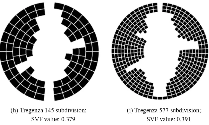
have been developed to capture the non-uniform distribution. The Tregenza method (Tregenza,
1987) is the most extensively used discretisation method in existing irradiance simulation
CHAPTER 2: A SIMPLIFIED VECTOR-BASED MODEL FOR URBAN-SCALE IRRADIANCE PREDICTION
- 27 -
equal area subdivided on the basis of 8 bands with an equal altitude width as illustrated in Figure
7. Any point within a similarly sized patch is considered as uniformly bright. The method was
later recommended by the Commission Internationale de l'Eclairage (CIE) as a standard model
for the purpose of a detailed daylight simulation. For cases where higher prediction accuracy is
needed, a more refined sky model can be created on the basis of the same principles in Tregenza
method; for instance, the tool Ladybug and Honeybee allows for creating a skydome with 577
smaller-sized patches, known as Reinhart Sky (Roudsari et al., 2013). It is stated in the tool
Ladybug and Honeybee that increased discretisation will result in a considerably increased
calculation time for the simulation. Several other proposals of sky discretisation also follow
similar principles with different discretisation resolutions (Freitas et al., 2015).
In these methods, each altitude band must have a different integer number of azimuth
segments to create all-sky patches with similar areas. As certain combinations of altitude and
azimuth bandwidths are required in this approach, users do not have full flexibility to create
different sky subdivisions tailored for their targeting applications. Alternatively, a
triangle-based discretisation approach was developed by Song et al. (2002) for the projection of an
equal-area global grid onto the sky. Schöttl et al. (2016) developed a triangle-based sky
discretisation that reduces the computational load by pre-processing and identifying the visible
sky nodes before the onset of the iterative calculation process. However, all these methods aim
to discretize the entire sky dome in a uniform manner.
In urban areas, most buildings are considered solid masses built on the ground with varying
heights as shown in Figure 7. Thus, it is very unlikely that parts of the buildings block only
some patches in the middle of the sky, as illustrated in Figure 8 (left subfigure). Indeed,
buildings typically obstruct the sky at various levels, starting from the ground level up to a
certain height, as illustrated in Figure 8 (right subfigure). Hence, the existing methods that are
based on uniform sky discretisation do not allow for efficiently representing the diffuse solar
radiation of the unobstructed skydome with the use of the minimal number of sky patches