ISSN (e): 2250-3021, ISSN (p): 2278-8719
Vol. 08, Issue 12 (December. 2018), ||V (IV) || PP 60-68
A Virtual Adaptive Curved Based Grid Localization for Wireless
Sensor Networks Using RSS
E.K. Girisan
1, S. Bhuvaneswari
2Associate Professor, Department of Computer Science, Sree Narayana Guru College, Coimbatore, Tamil Nadu, India1
MPhil Scholar, Department of Computer Science, Sree Narayana Guru College, Coimbatore, Tamil Nadu, India2
Corresponding Author:E.K. Girisan
Abstract:
Improving the localization accuracy is the major important process and reduces the system cost in the wireless sensor network by using the received signal strength and implementing the new algorithm VACG. In this proposed system VACG is used to overcome the limitation of CRVV that provides higher network traffic due to continuous updates which leads to high power consumption. VACG defines its parameters that generate the respective probability matrices for the non-anchor nodes to get localized. Proposed system identifies the unknown node is form in the wireless networks and obtained from neighboring anchors. Using the grid scan approach to virtual adaptive curved grid based node localization algorithm for improving the accuracy level. This algorithm is enhanced by using an adaptive strategy to establish the grid size. The performance of this experiment type is studied via analysis and simulation. The results achieved and verify that the proposed approaches provide better localization accuracy than challenging algorithms in the wireless sensor network.Keywords:
Rss, VACG Algorithm, Data mining,localization, received signal strength, connectivity, grid-scan approach.--- --- Date of Submission: 13-12-2018 Date of acceptance: 29-12-2018 --- ---
I.
INTRODUCTION
The localization is a basic term of Wireless Sensor Networks (WSNs), but it includes the critical issue and this issue increasing in every year. So, this is considering the problem of the wireless sensor network, the concept is solving this problem. The problem definition exposes the reason is, most of the WSN applications require the location of the sensor nodes that is, which place used in sensor nodes. The example of the sensor nodes is, (i) battlefield monitoring, (ii) environment surveillance, (iii) object tracking. The problem additionally mentions the term dependency, which means many WSN applications included routing protocols and network management techniques or methods is based on the location of each sensor node is available or not, that is one assumption based to take this node. This WSN additionally includes the only a small percentage of sensor nodes. This type of sensor nodes is called, "Anchors" (Links). This anchor is getting the location information from GPS (Global Positioning System) or another sophisticated and networking oriented technologies. Then, the remaining nodes are called the "unknown nodes", it is estimated the location information from the anchors. Many localization algorithms are available for Wireless Sensor Networks (WSNs), these all algorithms are based on two different categories like, (i) Range-based, (ii) Range-free. The first category previously measures the distance between two nodes. The measured distance is based on range –information that is, (1) TOA (Time Of Arrival), (2) TDOA (Time Difference Of Arrival), (3) AOA (Angle Of Arrival), or RSS (Received Signal Strength). This range-information is used for the location estimate. The multipath fading and measurement noise affects the estimation accuracy. The drawback of this category is complexity. The Second category is to localize the nodes. These localization nodes are based on the simple sensing information are (i) Wireless connectivity, (ii) Anchor proximity, (iii) Event detection. But this category is required a small range of system requirements, so this category is chosen for WSNs with limited hardware of node.
II.
PROBLEM DEFINITION
Many researchers using different data mining concepts then develops the WSNs and localization techniques. In this researches is grows the WSNs and localization algorithms.
In [1] Kiran Yedavalli et al. has presented the concept namely, “Sequence-based localization in wireless sensor networks". This concept divides the localization space. The localization space is divided into the number of distinct regions. The regions are uniquely identified by sequential order, which means ranking the distances from the reference nodes to regions. This concept includes symbolic notations such as, (i) n means reference nodes in the localization space, (ii) so, that nodes combinatorial called, O(nn), but these sequences are possible one. It is used into the geometric constraints, so the number of feasible that is, optimal location sequences is very low, so only O (n4). The location sequences are used in to develop localization techniques. The localization methods are robust, which means to reduce the errors, the bugs have come from the multipath and shadowing effects of wireless channels or signal. The lightweight localization technique provides better accuracy, and easy to compare the other. This accuracy is getting from through extensive systematic simulations and more time-tested experimental results. The better accuracy is less than other state-of-art radio signal strength-based localization techniques. It uses the RSS rank factor, so to forms the unknown nodes. It predetermines the list of all feasible location sequences from the localization space, so it is called, "Location sequence table". The Location sequence table finds the region, it represents the nearest node. The location sequence table expresses the maximum number of location sequences. But, this concept depends on the weak assumption. When the signal strength decreases with distance, this technique cannot be true.
In [3] the concept, “Distributed RSS-Based localization in WSN based on the second-order cone programming”, has presented by SlavisaTomic et al. The paper concept is to propose in this approach to optimize RSS based localization problem related to WSN. The network uses the iterative procedures and measurements between two adjacent nodes. The target node represents the position. To solve the localization problem by using the Maximum Likelihood (ML), it provides the ML-based efficient solutions. In another hand, to overcome the ML problem use the Second-Order Cone Programming (SOCP). In this term, additionally, introduce the approach for improving the convergence of the paper concept. This approach provides the computational complexity and energy consumption details. The concept is to provide the result estimation accuracy more than 1.5 m it compared in the previous system, it provides better accuracy. This approach requires the number of iterations or levels to converge. This approach cannot guarantee for all conditions. But the simulation results show the good result.
In [4] Chao Li et al. have presented the experimental approach, “RSS localization algorithm based on virtual sample nodes in WSN". The RSS technique is to apply in Virtual sample nodes. To collect the RSS vector of sample nodes based on off-line acquisition. Using the RSS vector samples nodes and to-be-located node, then directly calculates the likelihood probability, then find out the closest node, and calculates the coordinates by using the weighted centroid method. Finally, this survey paper concept provides, (i) High localization accuracy, (ii) Simple algorithm, (iii) low computation complexity. In this system use the IFA algorithm to reducing the increased anchor proportion. When changing the node number, it is not sensitive.
In [5] Kiran Yedavalli et al. have presented the echolocation based concept, "Echolocation: A sequence-based technique for RF localization in wireless sensor networks”. The sequence-based RF localization algorithm is called “Echolocation". The concept of RSS it takes and applies the multiple reference nodes. The constraint-based approach provides the robust location, and then the random RSS use the multipath fading and shadowing. This approach provides better accuracy. The echolocation analyzes the ordered sequence of nearby nodes that is reference nodes. The reference nodes include the locations. The unknown node includes the unknown locations. It already obtains the reference nodes that are with ranking, and then, RSS measurements between the unknown nodes. So, the measurement result shows that the how many order-constraints are satisfied, but this result is getting form comparison of ideal distance-based sequence for each location. The numbers of satisfied constraints are maximized from the location. The single localization technique does not provide the best accuracy for all unknown node locations, so this technique includes a hybrid localization technique. This technique is switched between the different localization techniques; it depends on (i) RF channel characteristics and (ii) node deployment parameters. So, it provides better accuracy for any single localization technique.
fixed range of sensors. The second approach is to ensure the network coverage and to minimize the mobile energy consumption and the range-adjustable sensors. The remaining three distributed optimization algorithm is to relocate the sensors and network coverage is optimized with better design and cost constraints that are the best logical constraints. Finally, it provides better accuracy for indoor environments. The drawback of this approach is if sometimes using the distributed optimization algorithms to provide less energy.
In [7] MariosSfendourakis et al. have presented the topology concept namely, "Sensor Networks-Localization and Topology.” This paper exposes the localization but doesn‟t take the account parameter of distance between SRs (Sensor Networks). Then, the type describes the localization in telemetry. So, the issues of network coverage and network topology are too analyzed. It, firstly give high importance to network problems. It easily understands the problems, but the network performance is affected. The network is affected by reason or a combination of attributes.
In [9] Kerri Stone et al. has presented the concept namely, “The Ins and outs of Distance-Based WSN Localization schemes". Localization is the basic problem of WSN and sensor location information is very complex for the data processing and understanding many applications. The GPS (Global Positioning System) is finding out the more locations, but it requires the high cost, so to location estimates is apply the GPS. The GPS cost is estimated is the very interesting researched concept of researchers, so it based on to develop the localization protocols and it determines the locations. The cost of location estimate is planned and it focuses the hardware side estimation, that is cheap hardware and wireless intra-network measurements are used in this work to get the better performance. To select the localization algorithm and it uses the WSN, but it critically understands the performance of an algorithm based on taking the different network topologies. It uses the different basic algorithm in this paper concept. These algorithms are compared each and every step and give the final result. Two algorithms take, that is DV-Distance and Robust Quadrilateral, then it is compared, it is well-known and generally uses the localization algorithm. The useful concept of this paper concept finally uses the five algorithms but these algorithms cannot exist, then it produces a realistic performance. This paper concept use the MDS-MAP algorithms, but it performs only best on the small networks, then, DV-Distance, TSL, and dwMDS performs very poorly on the large networks. The five algorithms are categorized by, (i) centralized, (ii) distributed, (iii) distributed-centralized, (iv) anchor-based, (v) cooperative.
In [11] Sc. Guowei Shen has presented the localization concept, but it expresses the "localization of active nodes within distributed ultra-wideband sensor networks in multipath environments”. The applications of WSN are used in localization technology, it which refers the term, “positioning or geolocation". The GPS is the traditional geolocation system, but it cannot design for indoor applications, so cannot provide the accurate location estimation of indoor scenarios. So, these two problems are solved by this concept. It uses the location and Tracking (LT) system that is, UWB (Ultra-WideBand). It combining the concerning size and the power consumption, and it provides the high precision based on distance estimation, and it allows the simultaneous localization and the data transmission. The main purposes of this system is investigated and develop practically and then, use the feasible localization algorithm included in distributed UWB sensor networks of the multipath environments. This working methodology is applied in each step in novel localization and tracking framework. It uses the number of procedures are, (i) ranging, (ii) Non-Line-Of-Sight (NLOS) identification and mitigation, (iii) location estimation, (iv) range modification, (v) range tracking, (vi) location estimation, (vii) location tracking. The MPCs (MultiPath Components) is main error source of the ranging step, it is based on range-based localization algorithm. In the paper have three algorithms are used namely, (i) Time Of Arrival (TOA), it is an estimation algorithm, (ii) Constant False Alarm Rate (CFAR), it is based on this alarming rate based method, (iii) Maximum Probability of Detection (MPD), it is based on maximum probability. So, the method is to improve the robustness of range estimators. This range estimator is included in multipath environments and the NLOS situations. The application of TOA is estimated the location in step by step, and it continued in large position errors it based on NLOS constraints. The approach differentiates between the nodes in Line-Of-Sight (LOS) and in NLOS positions. But the NLOS identification and mitigation is included by hypothesis testing method. This approach is determining the NLOS channel conditions and it comparing the mean square error of estimated ranges. Finally, produce the result gives the better accuracy. In this technique use the different tracking technique, that is Kalman Filter (KF), it is applied in both location tracking and range tracking. So, this localization framework is evaluated step by step and verified by using the ray-tracing area. This system finally, provides the design for the indoor scenario that is recorded by the Multiple-Input and Multiple-Output channel sounder system.
The background noise is measured by RSS models in both types. It also derives and evaluates the Maximum Likelihood Estimators (MLEs). The MLEs is extending and it is to estimate the transmit power and/or loss the path, it is known. The new model is to justify the measured data based RSS. It provides more accuracy based on the new model. But, this approach is a loss the path and the DRSS are to remove the parameters.
In this estimation approach [2] has presented by A.I.Alhasanat et al, to deliver the Wireless Sensor oriented experimental message are, “Direction of estimation approach for collaborative location in wireless sensor networks”. The collaborative location technique chooses the base term, “Direction of Estimation” (DoE). These directions are divided into two types, (i) Border-to-Centre (B-C), (ii) Centre-to-Border (C-B). These two types of directions investigate and evaluate the location accuracy. These two directions based experimental results show that the first direction outperforms the second direction, this results based on the term namely, "Root-Mean-Square-Error (RMSE)” and “Cramer-Rao Bound (CRB)”. The Border-to-Centre method is to use the different terms and node densities. This method is to decrease the errors of location estimation and it performs clearly, this performance greater than other methods. It accumulates the error, but increase the number of iterations.
III.
PROPOSED SYSTEM
The main objective of the proposed work is to obtain the location of sensor nodes by VACG. VACG is used to overcome the limitation of CRVV that provides higher network traffic due to continuous updates which leads to high power consumption. VACG defines its parameters that generate the respective probability matrices for the non-anchor nodes to get localized. RSS of the non-anchor node with VACG parameter are contributed to obtain the location estimate by evaluating the most probable sequence using soft output Viterbi Algorithm. The last state in the estimated sequence is returned as the location estimate of the non-anchor node. A performance comparison using simulation is done with CRVV.
System Design
The system design includes three modules namely Network model, Collection of RSS from non-anchor nodes and location estimation using VACG. Each module is described in detail in the subsequent sections.
Network Model
Initially, the network in a wireless region is randomly deployed with sensor nodes and it is shown in Figure 3.1. The area is divided into dynamic virtual mall grids of size n × n wherein the anchor node is spread randomly among regular sensor nodes that have the knowledge of its location using GPS. Other non-anchor sensor nodes estimate their location using RSS and connectivity based on the location of anchors. The anchor node is assumed to be static and the non-anchor sensor node is moving dynamically over the network.
Figure 3.1 Random deployments of Sensor Nodes
Collection of RSS from Non-Anchor Nodes
RSS measurement could be reliably acquired through the two-ray ground propagation model that computes the RSS of each node identified with the nodeID. With the support of anchor node, the RSS of the MN is collected with the nodeID. Because of the continuous movement of the node, the non-anchor node has many RSS expressed in dBm values. (Bardwell 2002) has shown the conversion of RSS in to dBm values. These dBm values are considered as the observation sequence length.
Location Estimation using VACG
The VACG method locates the randomly scattered non-anchor nodes (MN) in the outdoor environment with the help of anchor nodes. The area of grid size n × n for node follows the movement models to move from one grid to another. The sink or base station estimates the location of non-anchor nodes. Authors in the literature has estimated VACG parameters such that each state represents a location in the discrete physical observation and an observation from a state represents RSS reading from associated non-anchor node. During the operational stage, RSS interpretation from each non-anchor node and the VACG parameters are the necessary input to estimate the most probable sequence of states that results in the estimated location.
VACG parameters
VACGs extend existing CRVV by assuming that the states of the nodes are not observed directly. Hence, this model shows how the states (positions) relate to the actual observations (localizations). VACG can be used for localization process because it can model sequential stochastic processes or states, where probability of a state depends on previous states.
An VACG can be represented as = (R, S, A, B, ) where
R = {R1,R2,R3,…,RN} is the set of possible states, each state represents a dynamic virtual grid location in the physical space.
S = {S1,S2,S3,…,SM} is the set of observations from the model, each observation is an ordered pair of (non-anchor nodeID, RSS).
A = {aij} is the state transition probability matrix, where aij = P[qt+1 = Sj|qt=Si], 1 i, j N and qt is the state at time t.
B = {bj (k)} is the observation symbol probability distribution in state j, where bj (k) = P[Sk at t|qt=Rj], 1 j N, 1 k M and Sk are the output symbols at time t.
= { i} is the initial distribution, where i = P[q1 = Ri].
The VACG problem includes evaluating the sequence using state status estimating and the sequence using soft output Viterbi Algorithm. Therefore, the VACG is stated as: With a given sequence of observations O = (O1,…,OT), where T is a system parameter and each Oi S, 1 i T, the most probable sequence of location (states) Q = (q1,…,qt), where each qi R, 1 i T must be found.
Generation of probability matrix in VACG
The purpose is to build the VACG and estimate its parameters for the localization. The state transition probability matrix is obtained by the random node movement either in forward, backward, upward or downward direction and each state represents a location in the virtual grid. The node existence is identified by its transition probability of signal strength. The transition sequence length parameter is assumed to be „N‟.
VACG Algorithm for probability calculation:
Input: Set the area of the grid to realize the randomly distributed node transition. Output: Generate the transition probability for each node location in the grid. 1. Set the variables for the states as i, j, k =1
2. Initialize the left, right, top, bottom position as x1 , x2 , y1, y2
3. Initialize an array of size n x n grid for the position distribution probability of the target over the initial state.
5. for i varying from 1 to N sequence length 6. for j varying from 1 to N sequence length 7. Set count = 1;
8. Assign x1 = i ; x2 = i+1 ; y1 = j+1; y2 = j;
9. if (x1 - 1 > 0) , then increment count-to see if there are any states on left side; 10. update the matrix and state information
Further, the observation matrix (B) is attained by the location of anchor node to estimate the observation probability inside the grid. The anchor nodes direct the beacon messages and based on the response of RSS of the MN, B can be obtained. The observation sequence length parameter is assumed to be „M‟.
Location estimation from the node channel state sequence
or equal to 10, then the count is incremented by one until the state is found in the top direction If y2-1 is greater than zero, then the count is incremented by one until the state is found in the bottom direction. If x1-1 is greater than zero and if y1 is lesser than or equal to 10, then the count is incremented by one until the state is found diagonally above in the left direction. If x1-1 is greater than zero and if y2=1 is greater than zero, then the count is incremented by one until the state is found diagonally below in the left direction. If x2 is lesser than or equal to 10 and if y1 is lesser than or equal to 10, then the count is incremented by one until the state is found diagonally above in the right direction. If x2 is lesser than or equal to 10 and if y2 is greater than zero, then the count is incremented by one until the state is found diagonally below in the right direction. Once the direction of the state is determined, its co-ordinates are found.
The location is estimated from the state with respect to anchor nodes by dividing the area in units of hundreds and tens in the grid. If the state lies in the respective units, the conditions are checked to obtain the x and y coordinates of the non-anchor nodes.
Algorithm for Location Estimate from the State Sequence stauts Input: The estimated state in the grid
Output: x and y coordinates from the grid
1. Declare the variables for x and y coordinates 2. Initialize an array for the state sequence a[i] 3. for i varying from 1 to N grid size do 4. if a[i]==100, then assign x=0, y=9; 5. else
6. if a[i]==10, then assign x=9,y=9; 7. else
8. if a[i]>9, then find x 9. x=9 – { a[i]/10 }; 10. else
11. x=9; 12. y=a[i] % 10;
13. if y==0, then assign y=9; 14. else
15. y=y-1; 16. x=x*100; 17. y=y*100; 18. end for
19. x and y coordinates are obtained from the state sequence Algorithm for Location estimate from the state sequence
IV.
SIMULATION ENVIRONMENT
In order to evaluate and validate the performance of the VACG, simulation is carried out using Network Simulator-2 (NS-2, 2012). A network area of 1000 m × 1000 m is considered. It is divided into small grid of 100 units. Simulation parameters are shown in Table 4.1.
Table 4.1 Simulation Parameters for VACG
Network Area 1000 m × 1000 m
Antenna Type Omni Directional
Propagation Model Two-Ray Ground
Speed 2 – 10 m/s
Packet Size 512 bytes
Pause Time 5 s
Traffic type CBR
Initial energy 5.1 Joules
Performance Metrics
The performance metrics are defined below.
Estimation Error: It is the average distance between the estimated location and the actual location of all sensor nodes. The location error is scaled as the percentage of transmission range r.
Estimation Error = / /
Control Overhead: It is the total number of control packets transmitted by the anchors to localize an unknown node in each localization process. Assume to localize a node n, Bn beacons should be transmitted by An anchors. Then the average control overhead for an unknown node is given by
Control Overhead =( / )
Average Energy Dissipation: It is the average amount of energy spent by a sensor node during communication in the network.
V.
RESULTS AND ANALYSIS
The simulation results for VACG are compared with the existing CRVV and are analyzed to study the effect of node variation, varying transmission ranges for connectivity and various speeds.
Effect of varying the number of nodes
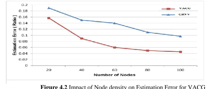
The evaluations on estimation error or localization accuracy over number of nodes for the speed of 10 m/s with the transmission range of 150 m are analysed for the proposed method. Increase in the number of nodes improves the localization accuracy for different movement models as shown in Figures 4.1, 4.2 and 4.3.
Figure 4.1 Impact of Node density on Estimation Error for proposed VACG
As expected, higher node density lowers the estimation error. The error estimate of proposed VACG proves to be better because each node moves near the other as a group with almost similar speed and direction. However, in comparison with other movement models, it has lowest relative speed because each node in a group chooses a random speed and direction according to the group leader. This specifies that for the VACG, nodes with RSS tend to adapt mobility and converge faster when compared with CRVV.
Figure 4.3 Impact of Node density on Estimation Error for proposed VACG
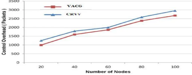
The performance of control overhead over node density is shown in Figures 3.9, 3.10 and 3.11.
Figure 4.4 Impact of Node density on Control Overhead for proposed VACG
The anchor node transmits a packet within its range to gather information from the neighboring node that increases control overhead. Non-anchor nodes overhearing this packet reply their known information to anchor node. The simulation endorses that VACG takes less overhead compared to existing method because of the state sequence rather than continuous updating of filters. Overall, the movement model behaves as per the functionality of the model, taking more overhead increases nodes density.
The effectiveness of average energy dissipated with respect to total number of nodes is shown in Figures 3.12, 3.13 and 3.14. The average energy spent when in movement is more, but actual energy spent in localization process is less. This shows that energy consumption varies due to increase in the node density. It is observed that for different movement model, average energy dissipation gradually decreases for larger density of nodes. The existing method in the CRVV model consumes more energy due to the grid size that requires continuous updating of the location and signal information.
Future Enhancement:
Future enhancement for this system, an improved version of VACG, denoted adaptive-VACG was proposed which uses an adaptive strategy to determine the grid size. This allows for good localization accuracy with low computational complexity. Performance results were presented to demonstrate the superiority of the proposed algorithms.
In this future enhancement of this localization accuracy by using the virtual adaptive curved grid based node localization and improving the event detection and combined the connection with received signal strength. Using this combined algorithm system can reduce the time out and accurate the signal strength status.
VI.
CONCLUSION
International organization of Scientific Research
68 | Page
REFERENCES
[1]. Kiran Yedavalli and BhaskarKrishnamachari. “Sequence-Based Localization in Wireless Sensor Networks”.
[2]. A.I.Alhasanat, B.S.Sharif, C.C.Tsimenidis, and S.Boussakta. “Collaborative Localization in Wireless Sensor Networks using Direction of Estimation Approach”.
[3]. SlavisaTomic, Marko Beko, Rui Dinis. In Wireless Sensor Networks using Distributed RSS-Based Localization and it based on Second-Order Cone Programming.
[4]. Chao Li, Xuezhen Huang, Liangrui Tang. “RSS Localization Algorithm Based on Virtual Sample Nodes in WSN”. [2017].
[5]. Kiran Yedavalli, BhaskarKrishnamachari, SharmilaRavula, Bhaskar Srinivasan. “A Sequence Based Technique for RF Localization in Wireless Sensor Networks: Ecolocation”.
[6]. Yipeng Qu. “Wireless Sensor Network Deployment”.
[7]. MariosSfendourakis, RajagopalNilavalan, Emmanuel Antonidakis. “Sensor Networks-Localization and Topology”.
[8]. Andrija S.Velimirovic, Goran Lj. Djordjevic, Maja M.Velimirovic, MilicaD.Jovanovic. “Range-Free Localization in Wireless sensor Networks using a Fuzzy Set-Based Approach”.
[9]. Kerri Stone, Tracy Camp. “Distance-Based (The Ins and Outs) WSN Localization Schemes”.
[10]. Sonia Goyal, Manjeet Singh Patterh. “Wireless Sensor Network Localization Based on BAT Algorithm”. [11]. M.Sc. Guowei Shen. “Multipath environments: Localization of active nodes within distributed
ultra-wideband sensor networks”.