Anthropology Theses Department of Anthropology
5-10-2019
From the Past to the Present: Collaborating on the
Production of a Community Museum in Chiquilá,
Quintana Roo, Mexico
Mikaela Razo
Follow this and additional works at:https://scholarworks.gsu.edu/anthro_theses
This Thesis is brought to you for free and open access by the Department of Anthropology at ScholarWorks @ Georgia State University. It has been accepted for inclusion in Anthropology Theses by an authorized administrator of ScholarWorks @ Georgia State University. For more information, please [email protected].
Recommended Citation
Razo, Mikaela, "From the Past to the Present: Collaborating on the Production of a Community Museum in Chiquilá, Quintana Roo, Mexico." Thesis, Georgia State University, 2019.
by
MIKAELA RAZO
Under the Direction of Dr. Jeffrey Glover, PhD
ABSTRACT
This thesis explores the process of facilitating the creation of a community museum in Chiquilá, Quintana Roo, Mexico. The growing presence of tourists travelling to Holbox Island, achieved by going through Chiquilá’s port, makes this project timely. Working with the Proyecto Costa Escondida (PCE), the Chiquilá Community Museum Project (CCMP) aspires to identify the dynamic relationship between the coastal inhabitants and the changing landscape, both past and present, through scientific investigations and local knowledge and make this knowledge accessible to the public. It is the accumulation of information through aforementioned means that allow us to collaborate with the Chiquilá community and other regional stakeholders to create a museum exhibit that aspires to do three things: empower the local population through collaboration, serve the community as a reliable source of information, and provide an adaptable and manageable platform for sustainable development. While this project focuses on the initial stages of this process, it is foundational for the development of the Chiquilá community museum.
by
MIKAELA RAZO
A Thesis Submitted in Partial Fulfillment of the Requirements for the Degree of Master of Arts
in the College of Arts and Sciences Georgia State University
Copyright by Mikaela Razo
by
MIKAELA RAZO
Committee Chair: Jeffrey Glover
Committee: Nicola Sharratt Louis Ruprecht
Electronic Version Approved:
DEDICATION
ACKNOWLEDGEMENTS
This thesis and project would not have been possible without the founders of PCE, Dr. Jeffrey Glover and Dr. Dominique Rissolo. I am extremely grateful for having the privilege to be a member of PCE and the opportunity to work with amazing and awe-inspiring people. I wanted to thank Dr. Nicola Sharratt and Dr. Louis Ruprecht who have both provided valuable assistance and advisement. To my committee as a whole for providing their support, showing passion, and giving kind words of encouragement. To Dr. Murtha who helped establish the Chiquilá Community Museum Project (CCMP) and has continuously supported it.
I am beyond grateful for Nathania Martinez who has been my biggest ally, friend, and the rock that has kept me grounded throughout this project. I am unable to properly describe her contributions to this thesis and the CCMP overall, nor can I thank her enough for all of the work she has put into this. I have complete faith that this project will succeed just based on her sheer determination and stubbornness.
To the people of Chiquilá and Solferino who have shown an interest in the project and have assisted in getting the project moving. Especially to Javier and Guadalupe who have offered food and a home to me and my colleagues. To Bolillo who has been a major advocate for the museum. And to Manuel and Lizette for being the first museum committee member and showing a passion for this project.
TABLE OF CONTENTS
ACKNOWLEDGEMENTS ... V
LIST OF TABLES ... XI
LIST OF FIGURES ... XII
1 INTRODUCTION... 1
1.1 Outline of this Thesis ... 3
2 THEORY ... 5
2.1 Introduction ... 5
2.2 Anthropology of Tourism ... 7
2.2.1 Heritage Tourism ... 7
2.2.2 Archaeotourism ... 10
2.2.3 Tourism as Major Determinant for Change ... 12
2.3 Archaeological Practice and the Public ... 16
2.3.1 Presenting the Right Aesthetic Effect ... 16
2.3.2 Working with the People ... 17
2.3.3 Applied Archaeology ... 19
2.4 The Role of Museums in Tourism and Anthropology ... 21
2.5 Theory in Relation to the Chiquilá Community Museum Project ... 25
3 BACKGROUND ... 27
3.2 Preclassic Period (2000 BCE – 250 CE) ... 31
3.2.1 The Preclassic Period in the Northern Maya Lowlands ... 31
3.3 Classic Period (250 – 1050/1100 CE) ... 32
3.3.1 The Classic Period in the Northern Lowlands ... 33
3.4 Postclassic Period (1100 – 1542 CE) ... 34
3.4.1 The Postclassic Period in the Northern Lowlands ... 35
3.5 From Then to Now ... 36
3.5.1 Contact and Historical Period ... 36
3.5.2 Yucatán Peninsula After the Caste War ... 37
3.5.3 Extractive Industries ... 38
3.5.4 A Territory Becomes a State and Ejidos Are Formed ... 39
3.5.5 The Cancun Project ... 40
3.5.6 Development of the Maya Riviera ... 41
3.5.7 Chiquilá ... 43
4 METHODS ... 47
4.1 Steps Taken in Preparation... 48
4.2 Collaborative Work ... 48
4.2.1 Collaboration with University of Florida ... 49
4.3 Identifying Stakeholders ... 50
4.3.2 Community stakeholder(s) ... 58
4.3.3 Proyecto Costa Escondida ... 59
4.3.4 Personal Position as a Stakeholder ... 60
4.4 Engagement and Community Collaboration... 62
4.5 Meetings ... 63
4.6 Proposal(s) ... 67
4.6.1 Proposal 1 ... 67
4.6.2 Proposal 2 ... 68
4.7 An Organized Museum... 69
5 THE CHIQUILÁ MUSEUM PROJECT... 71
5.1 A Change in Chiquilá ... 71
5.2 March 2019 Trip ... 76
5.2.1 Punta Laguna Monkey Preserve ... 76
5.2.2 Chance Encounters ... 86
5.3 The Inauguration Ceremony ... 93
5.4 The Museum as a Concept ... 94
5.4.1 Purpose Statement... 94
5.4.2 The “Big Idea” and Thematic Correlation ... 95
5.5 Tentative Content Categories ... 96
5.6.1 Aligning Content with Experts ... 99
5.7 The Palapa Downstairs ... 100
5.8 Potential of the Other Spaces ... 104
5.9 Implementation ... 106
5.10 Challenges ... 105
5.11 Current and Future Work ... 108
6 CONCLUSIONS ... 110
REFERENCES ... 111
APPENDICES ... 116
Appendix A ... 116
Appendix A.1 Proposal 1 ... 116
Appendix A.2 Proposal 2 ... 122
Appendix A.3 Proposal 2 Poster ... 130
Appendix B ... 133
Appendix B.1 Parador Turístico de Chiquilá (Chiquilá’s Tourist Parador) Proposal... 133
Appendix B.2 Invitation for the Chiquilá Tourist Parador Inauguration Ceremony (April 11, 2019) ... 138
Appendix C ... 141
LIST OF TABLES
Table 1 Vista Alegre Chronology (after Glover et al. 2019: 4) ... 29 Table 2 Proposed organization of topics for upper level of tourist parador ... 97 Table 3 Cultural topic with associated content experts contacted and those that should be
contacted ... 99 Table 4 Natural topic with associated content experts contacted and those that should be
LIST OF FIGURES
Figure 1 Location of the Yalahau Region (after Glover 2012: 272)... 2
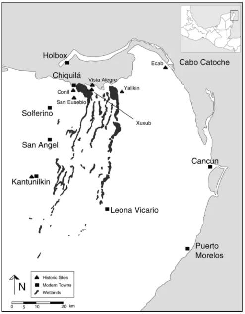
Figure 2 The Yalahau Region with sites and modern towns (after Glover 2012: 273) ... 2
Figure 3 Chiquilá town center and roundabout (glorieta) taken summer of 2017 (photo by Mikaela Razo) ... 45
Figure 4 Chiquilá town center and roundabout (glorieta) summer 2019 (photo by Mikaela Razo) ... 46
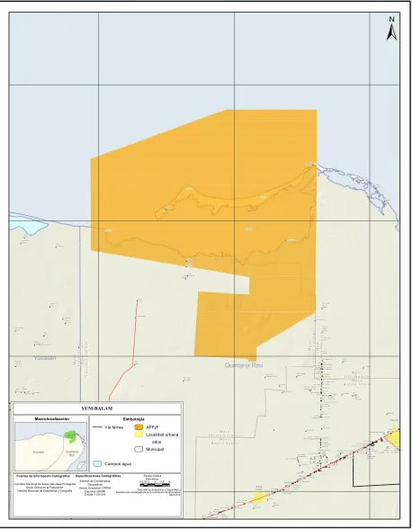
Figure 5 Yum Balam Natural Protected Area (CONANP) ... 56
Figure 6 (From left to right) Event coordinator, Omar Govea (Director of Projects and Tourist Infrastructure, SEDETUR), Sub-Secretary of Tourism, Nivardo Villanueva (Municipal President), Marisol Venegas (Secretary of Tourism for the State of Quintana Roo), and Valerio Mayoral (Mayor of Chiquilá) (photo by Mikaela Razo) ... 66
Figure 7 Newly constructed park circled to the East of the parador (photo by Nathania Martinez) ... 72
Figure 8 Current alcalde's office circled (photo by Nathania Martinez) ... 73
Figure 9 Picture of basketball court in 2017 (photo by Mikaela Razo) ... 74
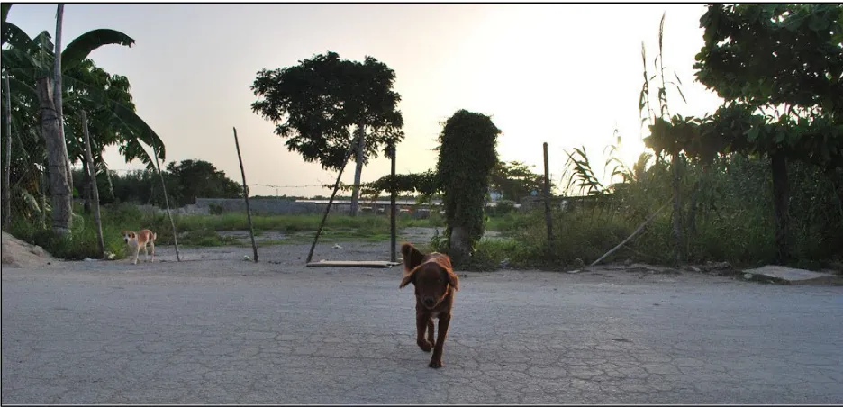
Figure 10 Picture of land lot behind dog in 2017 (photo by Mikaela Razo) ... 75
Figure 11 Picture of new construction of land lot in 2019 (photo by Mikaela Razo) ... 75
Figure 12 Cement road sign for Punta Laguna's Monkey Reserve (photo by Mikaela Razo) ... 78
Figure 13 CONANP designated signs for the protected area Otoch Ma’ax Yetel Kooh in which Punta Laguna’s Monkey Reserve resides (photo by Mikaela Razo) ... 79
Figure 15 Collaborating organizations that are listed on the bottom of each sign (photo by
Nathania Martinez) ... 81
Figure 16 Outdoor activities offered at Punta Laguna (photo by Mikaela Razo) ... 83
Figure 17 Protected animals in Punta Laguna (photo by Mikaela Razo) ... 84
Figure 18 Pictures of the ruins at the archaeological site in Otoch Ma'ax Yetel Kooh (photo by Mikaela Razo) ... 85
Figure 19 Our location (circled in red) in relation to the waterfront and ferry zone (photo by Nathania Martinez) ... 87
Figure 20 Photo of drone demonstration at the Primaria in Chiquilá (photo by Carlos Cisneros) 88 Figure 21 Lancheros (tourist boats) lined up on pier and along waterfront in Chiquilá (photo by Mikaela Razo) ... 89
Figure 22 Picture of Don Villo telling a story about Chiquilá (photo by Mikaela Razo)... 91
Figure 23 Picture of Dona Maria listening to Don Villo (photo by Mikaela Razo) ... 92
Figure 24 Panel layout for viewing observatory (upstairs parador), placed in the direction the resources they are describing are located... 98
Figure 25 Location of introduction panels on the first floor of the Parador ... 102
Figure 26 Outlined exhibit space within the enclosed side room ... 103
Figure 27 Design plan for new children's park and three shaded areas ... 105
Figure 28 Example of introduction panel for parador entrances (by Nathania Martinez) ... 107
Figure 29 Example of panel design (by Nathania Martinez) ... 102
Figure 30 Prior attempts at posters for community (courtesy of PCE)... 103
1 INTRODUCTION
This thesis is part of the Proyecto Costa Escondida (PCE), an interdisciplinary research project directed by Jeffrey Glover and Dominique Rissolo. The PCE is collaborative in nature and seeks to investigate the nature between coastal inhabitants and the natural environment of Mexico’s Yucatán Peninsula (Figure 1). As part of PCE and in collaboration with Tim Murtha and Nathania Martinez of the University of Florida (UF), I worked on launching a community museum in Chiquilá, Quintana Roo, Mexico. This thesis discusses the steps involved in getting this project off the ground as well as provides some foundational ideas about museum content, although I recognize that the final decisions about museum content should be driven by community interests (Figure 2).
The modern fishing town of Chiquilá is located on the north coast of the Yucatan Peninsula (Figure 2), in an area known as the Yalahau region (see Figure 1). It is at the center of this town that the Chiquilá Tourist Parador Project (CTPP) was designed to include: a center building on the
Figure 1 Location of the Yalahau Region (after Glover 2012: 272)
[image:17.612.183.430.372.688.2]1.1 Outline of this Thesis
Chapter 2 discusses the theoretical foundation for this thesis. Although highly interconnected, this chapter is broken down into three main topics: community or public archaeology, tourism, and museums. Since the large-scale development of Cancun on the Yucatan Peninsula beginning in the 1970s, tourism has been the largest contributor to the region’s economy. Understanding and acknowledging both the positive and negative effects of tourism and its various forms is significant to this thesis. Tourism development and the commodification of culture and heritage is not something that can be avoided in this part of Mexico. However, we can raise awareness and facilitate in the production of more sustainable practices in places like Chiquilá.
Chapter 3 provides the historical background of the Yucatan Peninsula, the Yalahau region, and Chiquilá. An introduction to Proyecto Costa Escondida (PCE) offers a brief insight to the investigations behind the culture history of Chiquilá and its legacy in the present. The following sections are then discussed chronologically from earliest evidence of human occupation, Spanish contact, to modern times. The more recent history, late 19th Century to now, is emphasized due to
its impact on the current socio-political environment and our interactions with the various stakeholders.
2 THEORY
2.1 Introduction
This project is about building a community museum in Chiquilá, Quintana Roo, Mexico using the knowledge gained from the PCE archaeological research, ecological knowledge from other scientists, and oral history of the community. My research is interdisciplinary in nature and thus draws on methods from applied and public archaeology, museum studies, and literature from tourism anthropology, among other fields. The final product contributes to the discussion on community-based museums, public engagement, tourism, and decolonizing practices.
In this section, I clearly define the following topics, as they are related to or used in my project: heritage tourism, development, archaeotourism, public engagement, community archaeology, applied archaeology, and community-based participatory research. These terms each have a distinct meaning that differentiates their placement within this thesis. To complement these terms and topics, I made a conscious effort to draw on case studies from Latin America, often close to Chiquilá, when I was able. While tourism is a cross-cultural phenomenon, the ways in which it has developed in Mesoamerica provides a more consistent and analogous set of examples for this thesis.
The homogeneity of a national identity can be ascertained through a critical examination of heritage tourism, which is premised on the commodification of a shared cultural heritage to make a profit (Muñoz-Fernández 2015: 70).
In contrast, public archaeology works with communities to determine more sustainable ways of benefiting from heritage tourism based on their interests. Public archaeology has thus emerged as a practice to collaborate with communities, educate the public and promote education with locals instead of for them (Bollwerk et al. 2015: 179). For this project, public archaeology is defined as the sharing of archaeological interpretations with the public (Atalay 2012: 50). While public archaeology is similar to community archaeology in that it engages the community, neither are necessarily community driven nor based on the equitable sharing of authority (Atalay 2012: 51). Community-based participatory research (CBPR), on the other hand, employs decolonizing methodologies to produce knowledge through equitable partnerships with the community (Atalay 2012: 11). Much like CBPR, applied archaeology aims to utilize emancipatory praxis through dialogues between insider-participants and outsider-consultants. Community involvement and collaboration in projects is thus a significant methodology in community-based research and applied projects.
2.2 Anthropology of Tourism
Tourism is a cross-cultural, commercial industry that has become an important component of the global economy. It has become easier for people and nations to participate in tourism as technology has eased the barriers between language and transportation. Over the past three decades, anthropologists have begun to study tourism in its own right; how it has emerged around the world, and its impact on places and people. Amanda Stronza (2001: 262) suggests the current literature is conceptually divided into two parts: one that centers on the origins of tourism, focusing its studies on tourists; while the other analyzes the impacts of tourism and centers on locals. This results in a partial analysis that reflects the disciplinary biases towards focusing on the negative impacts of tourism, instead of providing a holistic approach that addresses both positive and negative influences that it can have for communities. Like many other large-scale development projects, tourism provides a variety of pros and cons.
2.2.1 Heritage Tourism
intensity. In this way, the Mexican hotspot trivializes Maya heritage and transforms it into an affordable product used to entertain and attract foreign capital (Muñoz-Fernández 2015: 70). This can be seen when visiting Chichen Itza with vendors that line the walkways, selling almost identical items and marketing them as if their origins are as homogenous as the current commercialized Maya heritage and history.
Although tourism has been lauded as a catalyst for facilitating the development of unrecognized areas into thriving service-based economies, it has also introduced new social problems. In some cases, tourism disregards the education, health, and welfare needs of the local populations and has been associated with environmental degradation, luxury spending, and overcrowding. Tourism has thus evolved into a pioneer of neocolonialism (Stronza 2001: 268; Walker 2009: 101). Development and preservation are significant to the discussion on tourism because they are the foundation for the type of tourism that will take place. Archaeological site development and preservation are thus complex processes that require time, patience, funding, a diverse group of collaborators, and the knowledge to do so while also preserving and conserving any cultural material remains that exist in a place. These cultural material remains include, but are not limited to ceramics, tools, building structures, and burials. Issues concerning heritage tourism become more convoluted when local communities collide with the interests of outside developers and initiatives.
mismanagement become serious issues (Herrera et al. 2013: 285). These concerns became reality in Keushu, Peru. Keushu is a glacial lake that is surrounded by monumental ceremonial and mortuary architecture, dating back to the Initial Period (ca. 2000-900 BCE) (Herrera et al. 2013: 287). In 2006, the director of the local Natural History Museum spearheaded an initiative that had an Inca re-enactment ceremony at its core despite the site having no known relationship to the empire (Herrera et al. 2013: 287). The reinvented ritual was called Raymi Killa, a reference to the Cusco Inti Raymi religious ceremony honoring the Inca sun god (Herrera et al. 2013: 287).
2.2.2 Archaeotourism
Archaeotourism, or archaeological tourism, is defined as the visitation of archaeological sites as part of a person’s tourist activities (Griffith and Griffith 2012: 524). Unlike heritage tourism which commodifies heritage for profit, archaeotourism aims to promote and encourage public interest in archaeology and the preservation of sites, material remains, and history. As a facilitator in promoting or assisting in the conversion of heritage sites into tourist attractions, archaeology can be used as a powerful tool to construct systems of meaning that connects the past to the present (Brighton 2011: 345). This is especially apparent in Mexico, where the appropriation of ancient monuments and archaeological sites have been made into the national Mexican history instead of indigenous history (Ardren 2002: 380). The misuse and misrepresentation of their ancestors in the country’s broader narrative has disconnected descendent groups from their heritage (Castañeda 1997: 129; Ardren 2002: 380).
With the establishment of the Mexican state’s tourism ministry (FONATUR) in the 1960’s, the industry has drastically expanded and has demonstrated a willingness and ambition to pursue tourism development, and despite opposition, with little local involvement (Ardren 2002: 384-85). It is encouraged by the states on the Yucatan Peninsula, because it is the surest way to receive infrastructural support from the government and has potential economic benefits that accompany it (Ardren 2002: 385). Although these are influential incentives, tourism initiatives run the risk of suspending local culture into an idealized ethnographic present or an overly romanticized past (Griffith and Griffith 2012: 523) and raises ethical issues among anthropologists.
(PREP) is an archaeological project situated in Chunchucmil, a Classic Maya urban center in northwestern Yucatan, Mexico. While the project was originally concerned with studying the nature of an ancient Maya trading enclave, it has shifted to a more collaborative plan of research and development using academic archaeological inquiry as a foundation from which to generate tourism within local communities (Ardren 2002: 380). The modern village of Chunchucmil is made up of four ejidos (communal land grants): Kochol, primarily agricultural with farmer shifting from traditional crops like maize to cash crops like papayas; Coahuila and San Mateo are small agricultural communities with less active use of their ejido lands; and Halacho, located a bit farther from the ruins of Chunchucmil and mainly uses their lands for the pasturage of range cattle (Ardren 2002: 383). While the ejido communities of Chunchucmil were originally interested in the wages for project assistants, dialogues emerged with village elders and interested community members about what happens on archaeological projects and who ultimately benefits (Ardren 2002: 386).
contributions to the discussions about explaining and translating the concept of tourism to the community (Ardren 2002: 390). The living museum has potential to expand on local understandings of who tourists are or what they might pay to see and could provide a new form of interaction with them. The Pakbeh project’s collaboration in sharing and generating archaeological knowledge alongside the creation of a living museum shows how archaeology connects present Indigenous Maya communities to past sites and peoples, and how collaborative research can positively impact local communities.
2.2.3 Tourism as Major Determinant for Change
The adverse side effects of tourism are not just limited to heritage and culture but can also physically impact archaeological sites. The consequences of reckless development are clearly seen at two large cave sites in the Dominican Republic: Cueva de las Maravillas and Cueva Borbón. Lacking proper government involvement, human remains were removed from the former cave in the interest of making the site more accessible to tourists. Despite protests, modifications were made that included: cement walkways, an artificial lake and stream, floodlights, an electric lighting system, an elevator, a marble floor, and multiple skylights (Griffith and Griffith 2012: 527). This treatment interfered with the site’s qualifications for the United Nations Educational, Scientific and Cultural Organization (UNESCO) recognition, threatened the cultural patrimony of the Dominican Republic, and irrevocably altered the nature of the cave environment and the historical record (Griffith and Griffith 2012: 526).
tourism (Griffith and Griffith 2012: 529). Although the project was ambitiously conceived, it accurately illustrates how poor execution and uninformed development can affect the integrity of an archaeological site and any present or future research. The unsustainable and damaging nature of the cave’s modifications proves that a project must be careful with constructions lest they severely damage a site to the point that it is unable to be accurately displayed or even open.
Similar concerns have arisen with the cenotes and caves in eastern Quintana Roo, Mexico. In many ancient towns, cenotes were often the sole source of water and on occasion, there are still remains of miniature temples inside these sacred places. These cave shrines sites reside in one of the most rapidly expanding tourism zones in North America, placing many of the archaeological structures in danger (Rissolo et al. 2017: 613). The development of the environment as a tourist attraction has caused thousands of years’ worth of artifacts to be removed from cenotes in order to make them more swimmable (pers. comm. Rissolo, April 2019). Some sites are even being blasted or jackhammered to make way for stairways or paths, similar to modification made in Cueva de las Maravillas. This serves as a contrast to heritage tourism. In this case, heritage is purposely being destroyed or displaced for the intention of providing active or outdoor tourist services, like swimming or ziplining. These services, in conjunction with the more mainstream ones like visiting archaeological sites, is meant to capture a broader audience and thus increase cash flow.
goal was to promote sustainable tourism in the area that would help better protect the cultural and natural resources (Glover et al. 2012: 516). Strongly promoted by a non-profit organization based in Cancun, there were several cooperatives in Chiquilá affiliated with the Green Door initiative that utilized environmental tourism to generate profit (Glover et al. 2012: 515). This alternative form of tourism took advantage of the Yum Balam Protected Area but lacked tourism infrastructure and neglected the region’s archaeological sites (Glover et al. 2012: 516-17). Despite the initial agreement and interest in the cooperative, Puerta Verde seemingly failed due to limited or lack of equitable sharing of funds.
Holbox Island and the people that live there have also been greatly affected by the development of tourism. A recent study by Rubio-Cisneros and colleagues (2019) discusses how the Yucatan Peninsula’s growing anthropization threatens the coastal habitats and resources. The population on Holbox Island (Holbox) and the port of Chiquilá increased in the 1960’s when the government began organizing people into cooperatives (Rubio-Cisneros et al. 2019: 12). In the 1980’s, Chiquilá’s population grew when Mexico experienced an agricultural crisis that encouraged human coastal migration to exploit fishing and generate income (Rubio-Cisneros et al. 2019: 12). Population growth due to migration has increased the number of active fishers which has in turn led to a widespread “race to fish” that has depleted the local resources (Rubio-Cisneros et al. 2019: 16).
development of tourism on Holbox Island has generated a series of socio-environmental and landscape threats. These threats include water pollution, excessive plastic trash, toxic wastes, loss of the natural environment due to development, and more (Rubio-Cisneros et al. 2019: 14). This has contributed to the decrease in Holbox’s fishery resources.
The third way tourism is affecting life on Holbox is through the tourism jobs that are emerging on Holbox for fishers. The problem is that these jobs as boat captains, crew members, or whale shark swimming guides are mainly seasonal (Rubio-Cisneros et al. 2019: 14). Year-round employment comes in the form of “classic tours” which takes tourists to Yalahau’s iconic sites. Fishers commonly alternate these classic tours with fishing and there are some who work part-time as golf cart taxi drivers on the island (Rubio-Cisneros et al. 2019: 14). Fourth and finally, tourism development has affected the evolution of sociocultural values. The major conflicts revolve around the issue of selling communal land (ejido), a decision supported more strongly by young islanders than the older generations. This has created generational disparities in the valuation of money and given rise to new conflicts within the community, among families, and with government authorities (Rubio-Cisneros et al. 2019: 15).
of the island’s growing environmental crisis and raises the possibility for better marine management policies that can contribute to positive conservation measures.
2.3 Archaeological Practice and the Public
2.3.1 Presenting the Right Aesthetic Effect
Depending on the local context, community members can also take up active modes of determining what gets presented to the public. For some, it can be an empowering process in which they can redefine who they are and downplay or highlight preferred aspects of their identities (Stronza 2001: 273). Tourism can improve infrastructure, increase development and cash flow, and may also valorize local cultural traditions (Griffith and Griffith 2012: 523). Tourism is a means by which a nation or group can become popularized, homogenized, and made understandable, to both its own people as well as visitors (Díaz-Andreu 2013: 235). This is seen through the explicit and intentional selection of attributes that draw on popular and prevailing archetypes about certain groups of people by said people.
environment, allowing them to maintain their cultural identity and values without compromising their cultural integrity.
2.3.2 Working with the People
Although its definition varies across projects, the goals and methodologies used in public archaeology is relatively constant. Public archaeology draws on community collaboration to address the interests and needs of a community, increase the likelihood of long-term interest and engagement from locals, and empower groups through inclusion (Atalay 2010: 419; Thomas 2017: 15). Public archaeology slightly differs from community archaeology, which encompasses a broad range of practices that aims to actively engage the community with the local archaeology, primarily in the fieldwork stage (Atalay 2012: 49). These two methodologies are similar to community based participatory research but have been critiqued because neither are “fundamentally community-driven [n]or gives substantive control and decision-making authority to communities” (Atalay 2012: 51).
have an ethical right to not only be involved in the production of knowledge but also to the benefits of the research (Atalay 2012: 45).
Atalay (2010, 2012) discusses the CBPR project in Çatalhöyük, Turkey to demonstrate its collaborative model and methodology for democratizing research. Establishing the community as a research partner followed a series of steps: determining the community’s interest in becoming a partner and their level of interest, increasing the scientific and archaeological literacy and community capacity for research, and working with the community to prioritize archaeological education (Atalay 2010: 422-23). Although the CBPR project at Çatalhöyük is not quite prepared for conducting archaeological, heritage-related, or cultural tourism research, steps are being taken to build the framework to make it possible, including “an annual festival, archaeological lab-guide training for village children and young teen residents, a regular comic series (for children) and a newsletter (for adults)” (Atalay 2010: 423). As a result of positive community support, the project recently expanded to include a paid internship and an archaeological community theatre program.
performance at the annual children’s festival (Atalay 2010: 425). The program was meant to include aspects of cultural tourism, site management, and local development, addressing two things: the education of local schoolchildren on Çatalhöyük through their performance in the play, drama workshops, and active participation of the script; and engage the adults from Küçükköy and surrounding villages on the aforementioned topics (Atalay 2010: 425-26).
While Atalay’s role in these programs is to develop the theatre script and work with the interns, she speculates its success may have “widespread and long-term positive educational and financial impact[s]” (Atalay 2010: 426). The CBPR project will ideally “develop mutually beneficial collaborative projects with local communities”, moving out of her hands and further into those of the local Turkish communities (Atalay 2010: 426). In her book Community Based Archaeology (2012: 15), Atalay explains how the collaborative project did not follow the path she expected but has continued to grow, expanding on the community’s interest and trust in the research process. As each project progressed, they built community capacity for research and fund-raising while also increasing the local involvement in the protection, management, and heritage tourism at the Çatalhöyük site (Atalay 2012: 15). Atalay’s (2010, 2012) work at Çatalhöyük provides a good model for the practices used to involve a community during the archaeological process and collaborate with them to build community capacity for stewardship and research.
2.3.3 Applied Archaeology
encompass those who can be considered intermediaries, a third group that is both an insider-participant and an outsider-consultant while not fully conforming to either. Applied archaeology is a sub-discipline focused on developing the abilities to navigate the socio-political realms of a given community caused by the inherently political undercurrents of archaeology. Community collaboration is a methodology meant to involve and engage the public in the fate of their cultural heritage (Thomas 2017: 25), to democratize archaeological interpretations (Silverman 2011: 154), and serve as a link between the archaeological enterprise and different publics (Colwell-Chanthaphonh et al. 2008: 1).
This technique is not exclusive to applied anthropology, anthropological museums have also faced a growing mandate to make themselves more accessible to the public(s) they supposedly serve (Bollwerk et al. 2015: 180; Colwell-Chanthaphonh et al. 2008: 1). Successful engagement necessitates an exchange of information and knowledge between a museum and a community, creating a relationship instead of a hierarchy (Bollwerk et al. 2015: 180). In public archaeology, this is defined as a powerful tool in the decolonization process (Hoobler 2006: 457), serving as a way to empower local groups of people in becoming active partners, creating an equal and reciprocal partnership, and broadening the “methods used to assign value to physical objects” which extends beyond the physical and integrates the stories of collective identities of both the past and present (Bollwerk et al. 2015: 183).
share knowledge as it is of relevance and use to them (Atalay 2012: 7). It is a promotion of research with, by, and for indigenous and local communities.
2.4 The Role of Museums in Tourism and Anthropology
Alongside heritage sites, museums can be significant establishments within communities because they can be local organizations (Born 2006: 10) that can validate their contents and can serve as way to assume control of the archaeological stewardship (Hoobler 2006: 443). In Oaxaca, the southernmost state of Mexico, a group of community museums were founded to retain the archaeological finds recovered by archaeological projects within local areas. They are community driven cultural institutions that reaffirm local identity, preserve artifacts and history, and are utilized as an educational tool for both tourists and locals (Hoobler 2006: 444). They do so by storing local artifacts, employ locals to manage, and present information through community accepted means. Teresa Morales Lersch and Cuauhtémoc Camarena, two anthropologists from Mexico City, began working at the Oaxaca INAH office in the 1980’s and were enlisted to help the museum associated with the archaeological project in Santa Ana (Hoobler 2006: 448). Museo Shan-Dany in Santa Ana was initiated by the town and became economically self-sufficient by staffing through the local governmental system (Hoobler 2006: 449). This has created a mutually beneficial relationship between the locals and the institution, allowing these museums to continuously be community driven from beginning to end.
expectations of tourists, what locals think tourists want to see, and what corporations think locals should be doing to attract more capital (Castañeda 1997: 129). Castañeda dubs this the “economy of invention” in which archaeologists, tour guides, tourists, and artesanos and vendedores cycle between reaffirming and inventing Maya culture at Chichen Itza in Mexico; it is an “imaginary machine that orchestrates its own invention through the orchestration of heterogeneous practices as its data” (1997: 128-30).
For the Mexican government, Chichen Itza was created as a national park to reinforce a nationalist heritage and has been converted into a center for heritage tourism (McGuire 2008: 12). This designated national identity is naturalized through the daily experience of school education, bank notes, and other materials that are founded on the symbolic nature of objects within a museum. When a homogenized identity constitutes the majority of objects integral to day-to-day life and reinforced through a filtered historical narrative, a nation solidifies a controlled representational image. It is through these symbols and evoked feelings that tourism establishes itself within a place (Díaz-Andreu 2013: 235), generated on the very image a nation projected. While a homogenous national identity is part of nation building, it is important to acknowledge that it is rooted in colonial practices and exploitation.
that were rewritten during the Aztec conquest. For the residents of Xaltocan, a largely Indigenous community, collaborating with archaeologists is one of the ways they fight to have a voice in the process of historical production.
After enlisting Elizabeth Brumfiel’s help and granting her permission to work in 1987, the Xaltocan community has seen three full generations of scholars directing independent projects, established positive relationships, and had a regular and seasonal archaeological presence (Overholtzer and Argueta 2018: 513).The engagement of Xaltocan community members has likely had a significant impact on how they “negotiate their own identities and histories and their use of archaeological material culture, including the skeletons of their ancestors” (Overholtzer and Argueta 2018: 513). In maintaining control over the removal or display over material and human remains, the Xaltocan community is able to work against the silencing perpetuated and expropriated by nationalism (Overholtzer and Argueta 2018: 514).
As their collaborative work continued and with explicit permission from the Xaltocan community, the human remains discovered at the site were used as a focal point of interest for the local museum as well as public dissemination (Overholtzer and Argueta 2018: 516). When residents showed interest in further developing the local museum, a small exhibit was created in 2009 followed by a newer one in 2012. The descendent community strongly desired to study and display the human remains in publications, websites, videos, and museums (Overholtzer and Argueta 2018: 516). Since the museum has no colonial past as an institution, is established and entirely run by community members, and has displays and content specifically requested by the descendent community, it has faced no criticism in Mexico.
academics for emphasizing human remains (Overholtzer and Argueta 2018: 516-17). After Overholtzer submitted an article with a supplementary video that also focused on a group of burials to the Advances in Archaeological Practice (an SAA journal) it was cited as having unacceptable photographs. The editor told them to either pixelate the pictures or remove them altogether (Overholtzer and Argueta 2018: 517). The authors agreed that publicizing the collaborative project was more important than fighting for what the Xaltocan community “perceived as censorship from the imperial power to the north” (Overholtzer and Argueta 2018: 517). It should be noted that the censorship is due to the guidelines set by the SAA in order to respect, protect, and acknowledge the rights of Native Americans in North America to their material culture and human remains. While this may the case, the case of the Xaltocan community illustrates how academic policies have yet to expand the definition of who constitutes as a person of indigenous descent and the policies associated with their culture. Regardless of the censorship, the project went on to conduct an investigation into the perception of death within the Xaltocan community.
successful museum founded on the interest and enthusiasm from the Xaltocan community. In this case, museums are an empowering establishment that allows the community to be an authority over their own history and ancestral remains without compromising their identity and heritage.
2.5 Theory in Relation to the Chiquilá Community Museum Project
Understanding the various modes in which tourism develops within a place is significant in raising awareness for the risks and opportunities involved. Whether this is accomplished through the use of archaeology, heritage as it might be more broadly construed, or museums, understanding the effects is crucial in creating more sustainable long-term management plans. This is especially true when working with small-scale communities whose conceptions of tourism are based on the “success” of nearby and large-scale business endeavors. This is not to say that the development or success of tourism in a larger location is bad, nor that a successful product cannot be produced in a smaller community. While large-scale tourism development usually has the initial funding and support from various stakeholders, small-scale developments do not always have the same financing.
3 BACKGROUND
This chapter offers an introduction to the rich cultural history of the Yalahau region and Mesoamerica at large. The section begins with information about previous archaeological investigations that have greatly contributed to our knowledge about the occupational history of this region. This is followed by a section on the Maya in pre-Columbian periods, contact and historical periods, and the modernization of the Yucatan peninsula with the creation of the Cancun project and development of the Maya Riviera. The chapter is concluded with specific history about Chiquilá and its development.
3.1 Previous Archaeological Research
The sites of Vista Alegre and Conil were first documented by William T. Sanders when he visited the area in 1954. He performed test excavations and ceramic surface collections (Sanders 1955). After Sanders came Jack Eaton in 1968, who briefly visited Vista Alegre but did not conduct any archaeological work (Andrews 2002: 143). Anthony Andrews visited the area in 1976 and conducted a brief tour of Conil, a site he called Chiquilá after the neighboring town (Andrews 2002: 143). Susana Gurrola and Eugenia Romero recorded the site in greater detail when they returned to the area as part of their research on Holbox Lagoon and coastal trade in 1987 and 1988 (Gurrola Briones 1988; Romero and Gurrola Briones 1991, 1995).
during Terminal Classic and Postclassic period trade along the Peninsula (Glover et al. 2017: 9). This led to a short field season in 2005 as part of Glover’s PhD research and prompted the creation of the Costa Escondida Project (Glover et al. 2017: 9). In 2006, the first map of the site was published as part of Glover’s doctoral study (Glover 2006) and that map has been expanded during subsequent field seasons, specifically in 2008, 2011, and 2016.
The Proyecto Costa Escondida (PCE; the Hidden Coast Project) has been conducting archaeological research on the north coast of Quintana Roo, Mexico since 2006 under the direction of Jeffrey Glover, Dominique Rissolo, and many other contributors (Glover et al. 2012: 513). While the long-term goal of the project is to understand how the pre-Columbian and historical populations lived along the northern coastal region of Quintana Roo, the project researches both the environmental and social factors to understand the limits of and opportunities for adaptation in a dynamic and transforming coastal landscape through time (Glover et al. 2012: 513; Glover et al. 2017: 9).
the politics and economy of the Yucatan peninsula and in connecting the northern coast with other trade networks in Mexico and Central America.
Table 1 Vista Alegre Chronology (after Glover et al. 2019: 4)
PCE has encountered issues in the past in making the archaeological work and research accessible. Involving locals in the archaeological process through employment has helped in dispelling (but not eliminating) rumors about PCE’s work, a common issue on archaeological projects everywhere (Glover et al. 2012: 518). The researchers have disseminated their findings through a variety of different formats including copies of INAH issued permits, recent INAH reports, and any other relevant publications (Glover et al. 2012: 518). The demands and pressures of academia have transformed this process into an unrewarding task for one’s career as publications and promotions take precedence; this reflects the unilateral information exchange that currently exists within the academic world (Glover et al. 2012: 518). While unrewarding in terms of promotion and tenure, Glover and colleagues feel an ethical obligation to share this information with the community and have made a point to do so over the years.
maintenance of hiking trails to develop a regionally based cultural and natural resource preservation plan working with the local community; and (3) to develop a system of signage in the region and at Vista Alegre. This application was drafted in collaboration with Tim Murtha who was working at Pennsylvania State University (PSU) at the time. Unfortunately, the grant was not successful; however, it did initiate the collaboration with Murtha.
A Collaborative Design Research (CDR) grant application was submitted in 2017 to PSU to collaboratively engage and design a long-term natural and cultural preservation plan for the area surrounding the town of Chiquilá. The proposed research incorporates graphic design, archaeology, anthropology, landscape architecture, and geodesign to: (1) collaboratively engage stakeholders and community members in Chiquilá, (2) integrate the scientific information produced by ongoing research within a community based geodesign planning project, (3) develop a long-term master plan of preservation priorities, and (4) to create materials (like signage) to support and communicate the aforementioned plan. The application was accepted while Murtha was the director of the Hamer Center for Community Design at PSU and followed him to the University of Florida (UF). Murtha where his continued collaboration on the project along with that of his graduate student Nathania Martinez (UF) have been fundamental to the Chiquilá Community Museum Project (CCMP).
3.2 Preclassic Period (2000 BCE – 250 CE)
With the adaptation of agriculture and sedentism in Mesoamerica that marks the transition from the Archaic period to the Preclassic (or Formative) period, came the rapid increase in populations and the development of socially and politically more complex societies (Demarest 2008: 14). After 2000 BCE, a shared identity among the Preclassic Maya can be seen through the political and religious leadership of early chiefdoms made manifest in shared ceramic styles and site-planning principles. By 1500 – 1200 BCE some societies had public constructions, long-distance trading systems, and social hierarchies. The development of complex information systems included the beginnings of monumental art, iconography, and the calendric and writing systems (Demarest 2008: 14). These were later built upon by the Maya in the Classic period and other Mesoamerican societies.
Between 1000 to 400 BCE, the early complex societies transitioned into archaic states with more centralized political and religious authority, monumental art and public architecture, economic complexity, and social stratification (Demarest 2008: 15). This contributed to the continued development of the pan-Mesoamerican complex of information structures like the calendric, astronomical, iconographic, and writing systems. States with distinctive regional variants of Mesoamerican civilization begins emerging in the Maya region and elsewhere by 400 BCE (Demarest 2008: 15).
3.2.1 The Preclassic Period in the Northern Maya Lowlands
archaeologically detectable occupation of the region (Rissolo et al. 2005: 74; Glover et al. 2018: 4). The presence of ceramics in this period indicates that the first inhabitants of the Yalahau region rapidly developed their own ceramic traditions (Rissolo et al. 2005: 74), although these traditions were connected to the broader Nabanche tradition in the northern lowlands. Materials uncovered at the site of Vista Alegre (Figure 2), however, suggest people migrating from the eastern Petén-Belize regions (Glover et al. 2011b: 70) based on the similarity between some of the materials recovered at Vista Alegre and the Mamom tradition of the southern Maya lowlands. This is of particular interest because it demonstrates how coastal sites have perhaps always been places that have broader connections than their inland neighbors; a pattern repeated through time. The site’s population decreases between 400 to 75 BCE but sees a surge in population density from 75 BCE to 400/500 CE (Glover et al. 2018: 4).
3.3 Classic Period (250 – 1050/1100 CE)
The Classic period has been traditionally viewed as the “golden age” of ancient Maya society (Demarest 2008: 89). While this has been traditionally marked by the presence of monumental constructions and complex information systems, it is now known that these features began to emerge centuries earlier at some centers in the Maya highlands and lowlands. Classic Maya cities, however, do show evidence of social stratification with a distinct ruling class and an increased interconnectedness between religion, politics, and the elite.
the position as the city or state’s sacred center, embodying and ultimately becoming the axis of the universe (Demarest 2008: 207). Ideology was the major source of state power and a central element in the origins of Maya kingship. It is the dynamic relationship between rulers, the elite, religion, and other components of the state that manifests through monumental constructions, craft specialization, long-distance exchange trade, and information systems.
The end of the Classic period is usually identified as the “collapse” of ancient Maya, however, this notion underestimates and undermines the complexity of their civilization (Demarest 2008: 274). In reality, the Classic Maya civilization decline can be ascribed to various causes: collapsing states and political disintegration, migrating populations, environmental stresses, decreased resources, warfare, among others. This “collapse” is not a uniform phenomenon and has regional variability and is largely confined to the southern Maya lowlands. These Maya kingdoms were linked through kinship, communication, alliances through exchange networks, and shared cultural traditions. Their fluorescence in the Late Classic period, in conjunction with the expansion of an economic infrastructure that supported, was both the apogee of lowland Maya civilization and the foreshadowing of its collapse (Demarest 2008: 111).
3.3.1 The Classic Period in the Northern Lowlands
period (750/800 – 850/900 CE) by an unknown group of people. In the century following this reoccupation there is evidence of strong connections to the political economic network centered at Chichen Itza (Glover et al. 2018: 9).
Chichen Itza took advantage of the collapse of cities in the southern Maya lowlands. They become the dominant power in the northern lowlands by the 10thcentury CE (Braswell et al. 2018:
52), capitalizing on the disintegrating social, political, and economic systems. Chichen’s success can be attributed to its involvement in interregional coastal trade, its role as a religious pilgrimage center, and as a conquest state. Its ascendency was short-lived and by the 11thcentury CE, Chichen
began its decline as a dominating force. Inhabitants seemed to be deeply concerned with draughts and soil fertility which has been argued to have led to a declining population (Braswell et al. 2018: 55). Around the same time, there is a depopulation of Vista Alegre. The causes of this are still being investigated by PCE members, but there is no doubt that the collapse of Chichen played a role, but so might have rising sea-level (Jaijel et al. 2018). The north coast, however, is not abandoned, but the focus of coastal population seemed to shift to Conil in the Postclassic period.
3.4 Postclassic Period (1100 – 1542 CE)
Political power and religious authority shifted away from single individuals to lineages. These lineages re-emerged as the political and social unit of power (Demarest 2008: 278). Postclassic ceremonial centers were more modest compared to their Classic predecessors, while ancestral worship focused less on divine and royal ancestors to emphasize lineage and family shrines and idols. Centuries of warfare between sites had created long-standing enmity between the groups by the time of Spanish conquest. European discovery and subsequent conquest of the Maya kingdoms was the greatest trauma for the civilization (Demarest 2008: 286).
3.4.1 The Postclassic Period in the Northern Lowlands
Population in the Yalahau region increases again as people resettled in and around Terminal Preclassic / Early Classic sites during the Postclassic Period (1100-1550 CE) (Glover et al. 2018: 4). At this time, Vista Alegre’s function shifted to an important offertory or pilgrimage shrine-site (Glover et al. 2018: 6) while the main population center on the coast was Conil. Located 7 km west of Vista Alegre, the modern town of Chiquilá is in large part built upon the ruins of Conil. San Angel (Figure 2), a town 20 km south of Vista Alegre and Conil, might have been connected to the site of Conil if canoe travel was possible in Sabana Zanja as recorded in local oral history (Glover 2012: 281).
3.5 From Then to Now
3.5.1 Contact and Historical Period
On March 1, 1517 Francisco Hernández de Cordoba landed near the site of Ecab on the northeastern tip of the Peninsula. This established the first contact between the Spanish and the Yucatan Peninsula, as well as its “discovery” by the Occidental world. A year later, Juan de Grijalva visited Cozumel and the coastal site of Conil but quickly left (Andrews 1985: 139). In 1519, Hernán Cortés stopped in Conil and Cozumel before continuing on his route westwards to Veracruz and Tenochtitlan. The Maya were able to avert Spanish conquest and colonization in Central Mexico until Francisco de Montejo arrived. Previously a member of Grijalva’s and Cortés’ expeditions, Montejo led his own army and returned to the Yucatán Peninsula between 1527 and 1529. Montejo’s campaign was successful in conquering the Peninsula and marked with the establishment of Merida among the ransacked Maya city of Ti’ho on January 6th, 1542.
Following this came the violent and oppressive process of establishing land grants, or
Taking advantage of diminished control, the northeastern region of the Peninsula became a popular place for pirates to call home (Glover et al. 2011a: 208). By the mid-16th century, they
presented an increasing danger to the remaining coastal towns as they endangered and engaged in the log wood industries (Andrews 1985: 140). The Spanish had a strategic military presence along the north coast to not only defend the area from but to also monitor the (in their view) heretical indigenous refugees and buccaneers (Andrews 1985: 140). The region, however, became a backwater location (Glover et al. 2011a: 209) after the Spanish decided to abandon the region in the 17th century (Andrews 1985: 140). This does not mean the area was without inhabitants. On
the fringe of colonial authority, the dense forests served as a refuge for indigenous groups fleeing from the Spanish while the coast continued to offer harbors for pirating (Andrews 1985: 140).
The revolution for Mexican independence from Spain began in 1810 followed by 11 years of guerrilla warfare and the continued deterioration of living conditions for the Maya (; Gust and Mathews 2017: 145). Mexican independence was achieved on September 27, 1821 and Mexico became a federal republic in 1823 (Gust 2016: 55). Maya dissatisfaction with being suppressed led them to initiate the Caste War in July of 1847. The outbreak of the Caste War in the northern parts of Quintana Roo led to a stalemate in 1850, securing the eastern frontier for the Spanish and leaving the rebellious Maya groups to a self-proclaimed independent territory residing in the untamed forest of the East, what is now the modern state of Quintana Roo (Glover et al. 2011a: 209).
3.5.2 Yucatán Peninsula After the Caste War
the other to Faustino Martínez in 1889. La Compañía Agrícola El Cuyo y Anexas was granted a total of 1800 km2 including along the northern coast of the region, establishing company offices in
the indigenous town of Labcah, now Solferino, and focused on the sugarcane processing plant 3 kilometers south of Chiquilá’s port in San Eusebio (Gust 2016: 89). Supervised by Cubans, the cane was harvested by non-Yucatec Mexicans, Koreans, and Afro-Caribbean populations (Gust 2016: 90). The company also constructed a railway to connect Solferino to Chiquilá and was involved in the production and exportation of bananas, cacao, palo de tinte, cotton, tropical hardwoods, and cattle (Glover et al. 2011a: 210). Martínez did nothing with his land grant, and it was later acquired by La Compañía Colonizadora de la Costa Oriental de Yucatán in 1896. The company established six bases and constructed narrow-gauge railways which were used to transport products from extraction sites and in between bases (Glover 2006: 242).
3.5.3 Extractive Industries
For many decades, Yucatecan elites explored establishing viable and profitable large-scale industries. Sugar production on the Peninsula was attempted by Montejo as early as 1540 but was abandoned when the Montejo family was stripped of their encomienda (Gust 2016: 51). By the early 1800’s various extractive industries were reestablished in the Yucatan Peninsula due to the ideal soils and climate. Labor for extractive industries was mostly accomplished using
encomiendas founded on a peonage system. This system exploited laborers for the agricultural labor and tributes. The valuable goods produced at these large estates included sugar, mahogany, henequen, and palo de tinte.
the area. Aguardiente was utilized as a commodity to generate debts among existing laborers and to entice new workers (Mathews and Gust 2017: 160). These debts bound workers by law to
haciendas, managing a constant state of obligation and trapped in debt servitude. This continued the cycle of an exploitative labor and tribute-based system from the indigenous populations.
Besides sugar, the other extractive industries included: mahogany which was exported for building materials; palo de tinte was boiled down and amended with various metals for form multi-colored dyes, prized for its durability; and henequen which was used to make rope and other cordage (Gust 2016: 81). Henequen in the late 19th and early 20th centuries was mostly used to
make bailing twine for the United States market and made Merida one of the richest towns in Mexico at the time. With the exception of sugar, most of the resources were being produced for export, leaving the fate of the Yucatec economy in the hands of foreign interests (Gust 2016: 81-2).
3.5.4 A Territory Becomes a State and Ejidos Are Formed
Ejido landowners neither owned nor held title to the land, but rather had “usufruct rights to land and waters redistributed by the Mexican government” (Perramond 2008: 357). Despite the benefits of land redistribution, inequality and ethnic imbalances remained. These land reforms were not about rectifying past landholding imbalances in the Mexican countryside and was more about political patronage and creating new communal nuclei (Perramond 2008: 365). The population in northern Quintana Roo grew slowly over the next 50 years or so, with the first ejidos
being established in Kantunilkin, Solferino, and Leona Vicario. In 1992 came new legal reforms that altered the nature of ejidos in which local communities are able to divide the land into individually-owned parcels that can be leased or sold at their discretion (García-Frapolli et al. 2007: 138).
3.5.5 The Cancun Project
When the Territory of Quintana Roo became a state of the Mexican Republic on October 8th, 1974 (Glover 2006: 245), new doors opened for the development of tourist destinations. The
From the very beginning, it was designed as a business venture meant to benefit from and integrate into the international market. The positive side effects on the Mexican economy and regional development came second (Torres Maldonado 2000: 194). The goal was to complete the project at the end of 25 years and in three stages. The first stage (1972-1981) began with the announcement of the project and included plans for its creation and implementation, financial arrangements, and political negotiations (Torres Maldonado 2000: 198). After construction commenced, buildings in Cancun began growing at a rate faster than anyone had anticipated. The second phase (1982-1990) consisted of the continued development and construction, along with the establishment of basic services (Torres Maldonado 2000: 201). In the 1980’s, amidst Mexico’s economic crisis, Cancun did not encounter the same financial difficulties, instead the city experienced an influx of cashflow brought on by incoming tourists. The third stage (roughly 1990-2000) concluded most of the major constructions, turning Cancun into a modern urban city with plenty of potential and room to grow (Torres Maldonado 2000: 219). Cancun’s development and its popularity as a tourism hotspot, greatly affects the development of tourism and how people conceive of it across the state of Quintana Roo.
3.5.6 Development of the Maya Riviera
reasoned that the Maya Riviera communities would benefit because Carnival Cruise Lines promised to donate a share of their disembarkation fees to local governments for regional infrastructural needs (Walker 2009: 41).
On the other hand, opposition criticized the potential damage the massive ships could incur to the Great Maya Reef and warned that the new influx of tourists would push the indigenous Maya farther into poverty (Walker 2009: 41). In preparation for the construction of a home port at Xcaret, owners violated current ecological laws to transplant delicate coral. The Xcaret Home Port proposal created an “unlikely opposition alliance among Maya Riviera residents, environmentalists, Maya rights activists, and established tourism business providers” (Walker 2009: 41). They argued that the proposal threatened the economy and environment of the Maya Riviera.
An increase in cruise ships would lead to a reduction in flights coming and going from Cancun’s airport which would further reduce the occupancy level of the region’s hotels (Walker 2009: 41). Additionally, cruise ships don’t employ local citizens or pay local taxes, a decrease in hotel occupancy would result in a loss of jobs. Since the Maya Riviera generates 40 percent of Mexico’s total tourism revenue and 80 percent of the local economy – these losses would be devastating and widespread (Walker 2009: 42). The plans ended when it went before the Federal Fiscal Tribune of Judicial Power and was found to have made several violations that threatened the coral reef, endangered sea turtle colonies, failed to inform the local community of the planned development, and a few others (Walker 2009: 42).
2009: 43). Although Quintana Roo has a reputation for being one of the wealthiest states in Mexico with the highest growth rate, it is also home to some of the nation’s poorest and most malnourished residents (Walker 2009: 43).
3.5.7 Chiquilá
The historic period town of Conil was reestablished as the town of Chiquilá in the 19th
century (Glover et al. 2017: 7) and is part of the same ejido as the town of San Ángel. The area as it is known today has seen dramatic and dynamic changes over the last hundred years or so. Stories from some of the elders from the community recall how Chiquilá and Holbox have changed over the span of their lives (roughly 70 years). Don Villo and his wife, Doña Maria, recounted the white sandy beaches along the Laguna Yalahau shore before major infrastructure was developed in Chiquilá. Don Villo has also shared stories about how he used small boats to sail from Holbox to Chiquilá and back again, and how diverse and abundant the marine resources were. Don Chimay, another elder, has spoken of how Chiquilá was mostly abandoned more than 50 years ago and that his uncle used to be the only resident for a long time. When Chiquilá was first formed, it was established by small families from Holbox or the surrounding coast. Both Don Chimay and Don Villo have said that before the migration in the 80’s, the shore only had a couple wooden and thatched huts. Depending on the conditions along the shore, the location of different family’s huts changed. Don Villo moved his family more inland when his children were young because Dona Maria was bothered by the plethora of flies along the shore (pers. comm. Don Villo, March 2019). All three of them recall how the population and construction of Chiquilá changed about 40 years ago.
development of Cancun as a tourist destination, attracted people seeking employment and economic benefits. On the other hand, coastal migration was promoted in the 1980’s by the federal government. Dubbed the “March towards the sea” initiative, this occurred when Mexico experienced an agricultural crisis (Rubio-Cisneros 2019: 12). The aim was to exploit fisheries to generate income, an activity that intensified over the course of the late 20th and early 21st century
in Quintana Roo as continuing government policies and subsidies supported fishing and promoted tourism development (Rubio-Cisneros 2019: 13). This mixture of traditional and non-traditional descent communities presents challenges in making direct cultural connections with the past and does not guarantee that archaeology is seen as relevant (Glover et al. 2012: 515).
According to Don Villo and others from the community, the town of Chiquilá is made up of three colonias (groups): the natives, the Yucatecos, and the migrants. The native group consists of people like Don Villo and his family, whose families have lived in Chiquilá and the surrounding area for generations (pers. comm. Don Villo, March 2019). This is different from the Yucatecos
which is comprised of indigenous Maya who have lived in the Yucatan and moved to Chiquilá, although the time range for this is unclear (pers. comm. Don Villo, March 2019). The migrant group is made up of the people that moved to Chiquilá from the 1980’s up until now and continues to grow with the development of tourism. According to the Instituto Nacional de Estadística Geografía e Informática (National Institute of Statistics Geography and Information; INEGI), the population of Chiquilá in 2010 was 1,466 (INEGI 2010). During a recent visit, the Mayor has estimated Chiquilá’s population to be about 6,000 people (pers. comm. Valerio, March 2019), though this may be an exaggeration.
Chiquilá has gone through major infrastructural development along the main road. Recent changes can be seen in Figures 3 and 4, which display the difference in town construction from the summer of 2017 to 2018 respectively. These changes have been prompted by the need to keep up with the growing presence of tourists passing through and their demands. It is the dynamic history and record of change in Chiquilá and in the Yalahau region that should be presented, not only for the thousands of tourists that pass through annually, but also for the community.