CORINTH, 1969: FORUM AREA
(PLATES 1-12)
D URING the spring of 1969 the American School of Classical Studies continued
its excavations in Corinth within the limits of the Roman forum.' One purpose of this activity was to investigate further the area of the Sacred Spring, the other was to define better the shape and grade of the Hellenistic race course that lies beneath the Roman fills to the south of the Sacred Spring. Dr. Robinson directed the excava- tion on Temple Hill, immediately north of Archaic Temple where he started excavation last summer; Dr. Nancy Bookidis continued her work on the north slope of Acrocorinth, in the sanctuary of Demeter and Kore.2
THE HELLENISTIC RACE COURSE
The remains of two starting lines for pre-Roman race courses were discovered immediately west of the foundations for the west fa?ade of the Julian Basilica during the excavations of 1937.3 Only a small portion of the mid-section of the earlier starting line was then cleared; no test trenches were dug to determine its construction date. Apparently one of the main factors that forced the abandonment of the early course and its reorientation toward the southwest was the erection of the South Stoa and its terrace which would have constricted the free space around the finish line had the position of the race track not been changed (Fig. 10). It can only be suggested, at present, that the early race course was laid out in the fifth century; this course defi- nitely existed by the middle of the fourth century and was abandoned when the start- ing line of the later course was built over the earlier starting line. A water channel limited the south side of the later race track, with monuments south of the channel. Approximately 16 meters of this channel were exposed in the excavations of 1905
1 I most sincerely thank again this year Dr. Henry S. Robinson, Director of the School, for
his continued aid and interest in all aspects of the Corinth Excavation, and Mrs. Evangelia Deilaki, Ephor of Antiquities of the Argolid and Corinthia, also Professor Homer A. Thompson for his interest and criticism. The smooth operation of things curatorial and clerical is owed to Miss Kathryn Butt, aided by Mrs. Kenneth Sams. Photographic assistance was given by Ioannidou and Bartzioti. Special thanks are due Mr. Photios Notes for his continuous attention to the duties of excavation foreman, and Mr. Thomas Boyd for the high degree of precision he used in his share of this year's architectural drawings. The field supervisors during the spring session were Messrs. John Lavezzi and Hector Williams of the American School and Mr. Evert Rehnberg from the University of Goteborg, Sweden. I am indebted to all concerned for the successful completion of the 1969 excavation.
2 The reports of these two areas will be presented separately by the excavators.
3 Charles H. Morgan, II, " Excavations at Corinth, 1936-37," A.J.A., XLI, 1937, pp. 549-
550, pl. XVI.
Hesperia, XXXIX, .1
American School of Classical Studies at Athens is collaborating with JSTOR to digitize, preserve, and extend access to
Hesperia
I.7 .,J-
-
cc
w
-~ ~ C
.
. . '... -,I-.~ ~W. ,. c ~ ...
j~~ 1 ~~~~~~~~~~~~~~~~~~~~~~~~~~~~~
L~~~~~~~C
4.4
W~~~~
11
W coI~
CORINTH, 1969: FORUM AREA 3
and 1907.4 The north side of the race course was defined by the triglyph wall of the temenos of the Sacred Spring and by the monument bases that were erected on that wall, as well as by those monuments that were erected both to the east and to the west of the wall.5
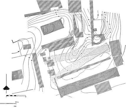
Six separate trenches were laid out this year along the south side of the race course (Fig. 1) in order to examine more fully the water channel that had been discovered in 1905 and in order to study the track surface and the fills beneath the track that are to be associated with the water channel.
This examination has shown that the shift in position of the late Hellenistic race course from its earlier line must have been made at the beginning of phase 8 of the Sacred Spring, not with phase 7 as had previously been suggested.6
It is clear, as well, that the racing surface of this later track was not truly level; rather it descended between 0.50 and 0.75 m. from the starting line at the east to its minimum height above sea level near the mid-point of the course. Thereafter the track apparently made a continuous ascent to the west. The west end of the course has not yet been found; it may have been destroyed by Roman construction and grading at the west end of the forum.
The water channel and six settling basins that limited the south side of the track have been uncovered in the course of this season's work from about the mid-point of the track westward to immediately east of Temple H. The system has been exposed, inclusive of baulks between trenches, for an overall distance of 63 m. The eastern- most of the exposed basins lies about 92.50 m. west of the starting line. Thereafter the basins appear to have been spaced, roughly, 9.90 m. on center. The basin immedi- ately west of the easternmost one is no longer preserved; only a pit testifies to its approximate position 9.90 m. from the first basin. The easternmost basin is 19.76 m. distant from the third, the fourth 9.87 m. from the third, the fifth 9.98 m. from the fourth, the sixth 9.92 m. from the fifth. (All measurements are from center to center.)
From the fifth settling basin westward, channel and basins are badly damaged and, in large part, removed, the result of the Roman building program in which this western incline was leveled in preparation for making it part of the forum. Even so the position of the western termination of the race course might be indicated by a Hellenistic reservoir discovered in 1935 west of Temples H and
J
(Fig. 4).7 This4 B. H. Hill refers to the channel as a possible part of the installation that brought water to the
Sacred Spring during the last years of Hellenistic Corinth. He does not, however, associate it with the Hellenistic race course. See Corinth, I, vi, p. 194, note 1.
5 B. H. Hill, Corinth, I, vi, pp. 185-199, figs. 119, 122, pl. XVII; also see C. K. Williams, II,
" Excavations at Corinth, 1968," Hesperia, XXXVIII, 1969, p. 52, fig. 6.
6 Ibid., pp. 49-52, fig. 6.
7 R. Stillwell, " Excavation in Corinth, 1934-1935," A. J. A., XL, 1936, p. 43. See also,
4 CHARLES K. WILLIAMS, II
has the plan of two interlocking rectangles of which only the lower walls are now preserved. It lies 173.45 m. west of the starting line and is on a direct line with the six basins and the water channel that limit the south side of the course. Its elevation is appropriate for the height of the race track if the degree of grade indi- cated between basins one and six is continued to the reservoir in question. Its complex shape indicates that it was more than just another basin of the system; rather, it may have been the westernmost of the series. The western end of the course thus may not have been far from this reservoir. The reservoir, when excavated, produced pottery datable to the end of Greek Corinth, ca. 146 B.C. At this time the race course also went out of use.
Much fill had to be brought in and laid down in the area immediately south of the Sacred Spring in order to produce the new, higher level needed for the dromos of the race course. This filling operation explains why much of the pottery found under the surface of the race track was of Neolithic date, with a heavy mixture of black-figured and red-figured sherds. The latest pottery from this fill is dated, at the earliest, to not much before the middle of the fourth century B.C.
1. Gnathian oinochoe. P1. 1.
C-69-138. Max. pres. Dim. 0.051 m. Clay well fired, tan going to orange at core; good black glaze, added white, yellow, and purple. Neck fragment, preserving base of vertical handle at shoulder.
Sloping shoulder with three horizontal bands of decoration, each separated by pairs of in- cised horizontal lines. Bottom band: branch in red with alternating red and white leaves on
both sides of branch, yellow dots between tips of upper leaves and incised lines. Second band: zigzag line going horizontally, white at bottom to yellow at top. Top band: ova outlined by incision, U in white paint inside, dots at bot- tom between ova. A second Gnathian frag- ment, base and lower body, found in similar fill. For shape see Lidia Forti, La Ceramica di Gnathia, pl. XXVI, d; for decorative arrange- ment, pl. XIV, a. Not before 360 B.C.
The clearest evidence for the date of the laying of the new race track comes, however, not from pottery from the fill but from pottery found in sand against a step in the poros cement floor which was covered by the fill brought in for the race course. Here were found almost complete pots, deposited in the 3rd quarter of the fourth century, apparently just before the filling operation started. This material includes the following:
2. Corcyrean (?) amphora with handle stamp. P1. 1. C-69-101. Pres. H. 0.633, max. D. 0.395 m. Clay pinkish tan, thin creamy slip. Almost complete.
Conical body, maximum diameter just below
nearly horizontal shoulder, paddling marks on upper body. Small, flaring rim with top sur- face concave. On top of handle, circular stamp with seven-petal palmette.
For almost exact parallel in shape, Athenian Agora P-6395, Deposit D15:3, deposit dated
CORINTH, 1969: FORUM AREA 5
to 3rd quarter of fourth century, in which was also found the imitation Cypriot amphora P- 6154 (Hesperia, XXXVIII, 1969, p. 59, fig. 9).
3. Coarse ware lekane. P1. 1.
C-69-102. H. 0.22, D. at rim 0.401, D. at base 0.142m. Clay brick red with sandy grit. Complete.
Ring foot, body flaring in shallow convex curve to outward curving, almost horizontal rim; two horizontal band handles.
4. Squat oinochoe. P1. 1, a, center.
C-69-133. Pres. H. 0.060, D. of body 0.085m. Fine buff Corinthian clay. Top of handle, upper neck and rim missing.
Flat base, squat ovoid body with maximum diameter just above base, continuous ovoid profile from base to narrow cylindrical neck; two wide body bands painted in black going brown in lower band, separated by reserved area with red line therein; two horizontal red bands just below shoulder zone. Shoulder de- coration of radiating tongues in black glaze; base of neck red, black glaze above. Second, similar oinochoe from same fill: C-69-134.
Samne class of oinochoe, close in shape, C- 40-17 (P1. 1, a, right), was found in context datable to late fourth-early third century B.C.
For same type, late fifth century, see C-34-1000 (P1. 1, a, left), Hesperita, VI, 1937, p. 282, fig. 20.
5. Imitation Cypriot amphora. P1. 1.
C-69-111. H. 0.274, max. D. 0.193m. Red-tan clay with some white inclusions, hard fired and with thin walls; cream slip, decoration in matt red and matt black. Com- plete profile, but with handles missing.
Flaring ring foot, ovoid body, slightly flar- ing cylindrical neck, outward flanged rim. Lower half of body undecorated, three hori- zontal bands, lowest black, second red, third black, zone above filled with three vertical branches alternating red and black on each side of pot between horizontal handles; black stroke running down handles onto body below han- dles. Shoulder, neck, and rim decorated in horizontal bands of red and black.
Neck and rim profile si'milar to C-68-181, Hesperia, XXXVIII, 1969, p. 57, fig. 8.
6. Imitation Cypriot amphora. P1. 1.
C-69-137. Max. pres. H. 0.20, max. body D. 0.194m.
Reddish clay with white inclusions, hard fired with thin walls, poor cream to gray slip. Deco- ration in matt black and dilute red. Neck, rim and one handle missing.
RiEng foot, ovoid body, horizontal handles rising vertically. Two horizontal red bands at mid body, pattern of upper body zone, handles, shoulder similar to No. 5.
CONSTRUCTION DATE
6 CHARLES K. WILLIAMS, II
construction of the South Stoa. The newly oriented race course may have been part of a plan to redesign the low area south of Temple Hill at the time of the erection of the South Stoa.
SOUTH SIDE (Fig. 1)
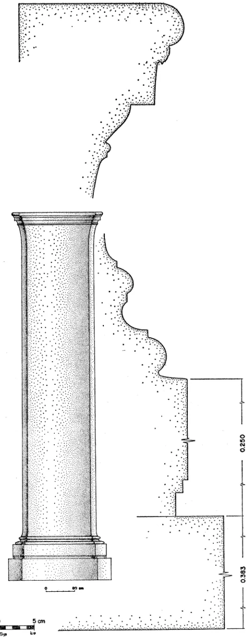
A poros monument base was discovered and cleared this year 3.83 m. east of the easternmost draw basin of the water channel that defines the south side of the Hellenistic race course. The base had been constructed, however, well before the race course was laid out; in fact the monument was slightly in the way of the water channel since, when the channel was constructed, it had to be cut into the step along the north side of the monument.
The base, a rectangular, two-course construction consisting of euthynteria and step, is destroyed at its southwest corner. At the step course the monument measures 3.94 m. north-south by 5.00 m. east-west. A cyma reversa moulding runs around the inside of the tread of the step, delineates a rectangular area 2.945 m. north-south by 4.157 m. east-west, and forms a lip behind which the plinth of the statue group was sunk 0.03 m. (Fig. 2). This lip defines a sunken area or bed into which a superimposed course was set, a device found on other dedicatory monuments, devised, apparently, so that a superimposed course would be held securely without being doweled or clamped. The technique is also used in wall construction in Corinth, a good example of which runs along the north side of the roadway that passes to the north of the temenos of the Sacred Spring (P1. 3, a).8 Here is preserved a wall socle with recessed bed for its orthostates.
The plinth of the statue that originally rested on the poros monument base is now completely missing, as is the statue group. The plinth probably was executed either in marble or in Argos black stone; the pry holes for the setting of the twelve plinth blocks are visible in the poros rectangle prepared for the plinth. Also, three lead wedges used to level the blocks were found on this surface, two still adhering to the sunken bed. The statue group, four horses, perhaps a groom, and chariot, were executed in bronze and doweled into the plinth. The circular holes for the dowels were drilled completely through the plinth course and into the poros below, within the rectangle delineated by the cyma reversa moulding of the step tread. The position of the four horses, as determined from the dowels that anchored them in place, is typical for a quadriga group (Pl. 2) .'
8 Monument bases set into recessed beds are to be found on the south triglyph wall of the
temenos of the Sacred Spring, Hill, Corinth, I, vi, figs. 115, 116; socle for wall north of roadway, Hill, pp. 20, 22; monument at Delphi, Fouilles de Delphes, II, La terrasse du temple, pp. 255-257, figs. 199, 199 bis, base 4; the device is common at Olympia, Olympia, Die Ergebnisse, II, 1896, pl. LXXXXII, base with Praxiteles dedication.
CORINTH, 1969: FORUM AREA 7
PROBABLE STONE PLINTH Restored____ HELLENISTIC HESURFACINA OFRACE COURSE
CUT AWAT FOR WATER CHANNEL
~~~~~ i i ii 4~~~~~~~~~~~~~~~~~~~~~~~-LATE 4 TH C. RACE COURSE 4--POROS-CEMENT FL. , PRE -COURSE
--- 4-PROBAL ORIGINAL FLOOR FOR AAAORGA BASE (ANEXCAVATED) Q U AD RI GA BASE, SECTION, LOOKING WEST
Restored Section looking West.
4.157m.
A
TEn CHANNEL OF
WATER CHANN _ _ R
RACE COURS
t (TENCH DUG TO EXPOSE
N~~~~~~~~~~~~~~~~~~~~1N
<TnENCH DUG RESTORED STONE TO EXPOSE BASE TO STATUE
_________ Al
Restored Plan.
8 CHARLES K. WILLIAMS, II
The quadriga group, facing east, had the trace horses striding ahead of the central pair. The trace horse at the north had its right front hoof forward and the tip of its tail apparently doweled to the stone base; the horse to its south had its left front hoof forward. The third horse, slightly ahead of the second, had its right front hoof forward, and the fourth its left forward.
Immediately in front of the second horse from the north is a circular dowel cutting, perhaps for a foot of the groom. The back of the podium was reserved for the chariot, each of its wheels secured to the base by pairs of square dowels rather than by circular ones similar to those used to hold the feet of the horses. The circular dowel cuttings in the poros base are between 0.06 and 0.07 m. in diameter.
A line of poros blocks 0.37 m. wide is visible in the poros cement floor that im- mediately underlies the late race course; it extends northward from the northwest corner of the step course of the quadriga base for 4.50 m. (Fig. 1). Here one line of poros blocks goes eastward, a second narrower line, perhaps originally constructed as a step or curb, stretches seven meters northwest into unexcavated fill. These three lines of poros blocks belong to the earliest period of the quadriga base and are par- tially covered by the poros cement floor that immediately preceded the Hellenistic race course. Further excavation in this area is necessary in order to determine the exact design and function of these lines of poros blocks.
The quadriga base was apparently erected by the first years of the fourth century B.C. Tests made at the front and south side of the base produced few sherds from the bottom levels; these, however, were fifth century in date. Also, the floor levels that had accumulated against the base before the Hellenistic race course fill was brought in show that the monument had been standing for some time before the race track was built (Fig. 2, top). There is a hard floor level that goes with the original period of the monument; above this is a heavy fill covered by a cement-hard floor of poros chips. On the south side of the monument this floor came up to the top of the monument step. Above this are a series of cement floors that accumulated over the step and at least to the top of its cyma moulding. Over the poros monument where the statues originally had stood, the soil was soft and contained large quantities of late Hellenistic pottery, most of which were Megarian bowls, witness to the fact that the Romans dismantled the statue with the sack of Corinth in 146 B.C.
POTTERY FROM OVER THE MONUMENT BASE:
7. Megarian bowl. P1. 3.
C-69-140. H. 0.071, est. Diam. 0.130m. Clay buff, probably Corinthian, traces of dull black glaze.
Complete profile.
Medallion: concave at center with one fram- ing groove, plain area and two grooves at edge
of medallion. Body: ova in one line at base of body picked out in plastic lines, circles at their center, net pattern above fading out to rim which was added by wheel. Vertical to slightly flaring rim.
8. Megarian bowl. P1. 3.
CORINTH, 1969: FORUM AREA 9
Clay light green, traces of dull black glaze. About one-third of pot preserved.
Medallion: four akanthos leaves in form of cross, framed by two ridges. Alternating akan- thos, long pointed, and long rounded leaves radiating from disc; above, row of ova then guilloche band; plain, wide rim added by wheel. With these bowls were found the following, also inventoried, Megarian bowls of more com- mon design: C-69-126, C-69-146, C-69-148, C- 69-149, C-69-150, C-69-151.
9. Kyathos. P1. 3.
C-69-78. H. of body 0.041, max. Diam. 0.050 m.
Clay buff, glaze from brown to dark gray. Handle missing.
Flat base flaring to maximum diameter of body close to base, thereafter tapering slightly inward to rim, vertical lip; two wide grooves just below lip on outside; base of strap loop handle preserved where it joins body just below lip.
No. 9 not from soil associated with bowls Nos. 7, 8; many fragments similar to No. 9 found, however, with the bowls. See Corinth
LOT 5812.
The foundation for a second, large monument lies 10.90 m. west of the quadriga base (Fig. 1, P1. 2, a). It is preserved only to socle level; it was built, apparently, after the construction of the race course.10 The foundation is 2.39 m. wide at the east, 2.36 m. at the west, measuring from north to south; it is 5.03 m. from east to west. The foundation is not a neat rectangle nor does it run exactly parallel to the drain of the race course.
This monument, as well as certain large bases on the north side of the race track, is large enough to have carried a group of two horses and chariot, i.e., a biga rather than a quadriga as did the monument discovered this year. There are indica- tions that more than one dedication of a chariot were erected in this area."
Farther west along the race course, immediately south of the fourth draw basin, lies a third structure, this one partly excavated in 1938. Whatever function the monument had in the early Roman period,'2 it was a fountain house in the fourth century B.C.; it may have been built even earlier.
The structure, as originally designed, was in the form of a ramped fountain house of extremely small scale, oriented approximately east-west (Fig. 3, P1. 3, b). Its overall preserved dimensions are 3.20? m. east-west by about 1.50 m. north-south. The exterior ground level was between 77.71 and 77.80 m. above sea level. The high- est course preserved of the original walls of the fountain house rose to no more than
10 This monument was partially cleared in the excavations of 1905 and had been completely
excavated before 1969.
11 B. D. Meritt, Corinth, VIII, i, p. 36, no. 30. This inscribed plinth cannot be identified as belonging to the quadriga monument uncovered this year since, apparently, the dowels for securing the statue group to the inscribed plinth would not have gone completely through the thickness of the marble and thus not have penetrated into the course below.
12 Morgan, A.J.A., XLIII, 1939, p. 264, tentatively identified as a shrine of the early Imperial
10 CHARLES K. WILLIAMS, II
97790 } (;9
469TT610 Of'-' \
FORUWATING S * 1 1l | >DESTROYED
ARF A
CHANNEL Stat looking South.
MARBLEE -7639
ACTUAL
STATE
Present State looking South.
.lt.~~~~~~~~~~ I Mm.
RESTORED
STATE
Restored Section looking South.
CORINTH, 1969: FORUM AREA 11 0.10-0.20 m. above ground. Whether, originally, another course rose higher cannot be determined. The two poros blocks that do rise higher now on the north wall of the rampway are of a later date than the original structure. From ground level down- ward there may originally have been a series of steps, now pillaged, which led from the west to the narrow ramp which starts at 77.05 m. above sea level. The ramp slopes eastward for a length of 1.46 m. to 76.58 m. above sea level. Here the poros ramp stops against a horizontal floor built of a single thick marble block. An upright marble veneer slab, 0.075 m. thick, was set into the east poros wall and rose to a height of 0.41 m. above the marble floor. Thle marble floor and wall slab, today badly damaged from alterations and re-uses, were built into the fountain house to protect the soft poros blocks from the continuous wear and erosion to which they would have been exposed by the constant dripping of water from the fountain spout above. This device for the protection of erodible surfaces from falling water is also found elsewhere in Corinth."3
The fountain house was supplied by a channel that brought water from the west and which passed along its south wall (P1. 3, a, no. 1). The water course has now been traced to the foundations of the west side of the early Roman altar about 22 m. farther east. An outlet must have been constructed at the point where the water channel passed immediately south of the marble floor of the fountain house, allowing water to fall to the floor below. The wall of the fountain house is, unfortunately, destroyed at this point. Wherever the water supply system has been cleared it has been found that the channel was removed from the trench; this appears to have been done after the middle of the fourth century B.C. The cutting for the channel, how- ever, is easily traced in the hard cement floors which surround the remains of the fountain house and in a poros cement floor, which resembles bedrock, farther to the east. A second structure was also served by the water that flowed through this system. This is a stuccoed poros basin which lies two meters west of the fountain house (P1. 3, a, no. 2). The top of the basin was at ground level, its lip rising only slightly above the cement floor. The south side of the basin had a narrow backing wall, 0.20 m. wide, running its length, traces of which are still preserved. The main east-west water supply channel, already discussed, ran at 1.25 m. south of the basin and fed the basin through a right-angle arm of which only the cutting is now par- tially preserved. The basin then received its water through a small hole in the south wall of the basin. No provisions were made to drain the basin.
The fountain house and the water basin appear to have been erected and to have
13The mid-fifth century B.c. reservoir of the dye works in the Peribolos of Apollo has a
12 CHARLES K. WILLIAMS, II
been in use contemporaneously; they probably also went out of use at the same time. The date for the abandonment of the fountain house cannot be determined, however, for it is now the scarred victim of too much re-use and too many reclearings.
An indication for the approximate date of destruction of the water channel and abandonment of the fountain house and basin can be had from the latest sherds in the undisturbed fill within their abandoned water supply system. The latest fragment is a skyphos base of the middle of the fourth century B.C.; a skyphos of the first half
of the fourth century was recovered from the fill within the water basin, sealed by a cement floor.'4 The system probably went out of use in the second half of the fourth century. The abandonment of this complex appears to have been contempo- raneous with the construction of the Hellenistic race course. This terminal date seems probable since the cement floor that was used with the fountain house was broken through when the water channel for the race course was constructed; the next cement floor laid covered the water basin and sealed the fill in it. This second floor was contemporaneous with or slightly later than the settling basin of the race course channel (P1. 3, b, no. 4), for it ended against the poros blocks of the later channel and was not broken by the channel. It it even probable that the poros blocks of the water channel that served the fountain house and basin are those same poros channel blocks that thereafter were re-used to define the south side of the race course.
CEMETERY OF THE EARLY IRON AGE AT THE WEST END OF THE RACE COURSE
(FIG. 4)
The west end of the Roman forum covers the area that, earlier, had been used as an Early Iron Age cemetery. At the time of the cemetery, however, the contours were not those of a leveled terrace but rather of a slope rising to the west, forming the northwest side of the head of the Lechaion Road Valley (Fig. 10).15 Some early graves had already been excavated in this area in earlier American School excavations.16 Work within the past two years has brought to light six more burials, three of which are Sub-Mycenaean, one Protogeometric to Transitional, and two Geometric (Fig. 4). A broad strip of undug fill still lies to the west of Temples H,
14 Corinth LOT 5810 for fill within the abandoned water channel trench; Corinth LOT 5778 for the fill within the basin.
15 See below, p. 49 ff.
16 For Protocorinthian grave within the foundations of Temple F, see 0. Broneer, " Excava-
80.33 78
*75,50' 4 C. DRAIN
TEMPLE GI-OMP Di
WELL~~'B B,U
PRO OGEOMETRIC GRAVE
GEOMyETRR IC
TEM PLE
BASIN FOR RACE COURSE? ...
U N E X C AVAT E D
-YSUB -MYCENAEAN GRAVES GEOMETRIC
G QAMPHORA GEOMETRIC GRAVE
TEMPLE -4th C. DRA&N G
WE
2 .54
,, . 5 M ~~~~~~~~~~~~~~~~~~~T~GRNHIAN
14 CHARLES K. WILLIAMS, II
J, and K, in which, without doubt, lie more graves. Other graves apparently had been destroyed in the course of the erection of the Roman temples of the west end of the forum and with the erection of the Roman West Shops.17
The three Sub-Mycenaean interments, two skeletons in one grave, the third in a grave of its own, were found between 3.10 and 4.50 m. northwest of Temple G (Fig. 4, Pls. 4, 5). These burials were placed in contiguous pits and oriented in the same direction; the two graves resemble each other closely in construction. They are the first burials identified as Sub-Mycenaean in Ancient Corinth."8
The northern grave had its west end wall removed by the Turkish builders of a well shaft (Pl. 4, a, 5, b); the grave was otherwise undisturbed and the skeleton was intact. The grave was a rectangular pit in pure Neolithic fill and had its lip reinforced with a rim of uncut stones that made a mouth opening about 0.40 m. wide north-south by an estimated 0.90 m. long east-west. It had been covered after the burial with a course of rust-colored, unbaked mud bricks. The bricks, although caved in over the center of the grave, still sealed the burial. Probably they had originally been supported by wood resting on the stone lip of the grave but long since disintegrated. No trace of wood was found when the grave was opened.
The skeleton was that of a child of about seven years, lying on its back with head at the west, hands across its stomach, legs pulled up with knees to the north, feet pointed. It had a bow fibula of bronze on its left shoulder (P1. 5, a) and wore an iron ring on a finger of its left hand. The deceased had been laid on a bed of egg-sized rocks which covered the whole of the bottom of the grave pit.
10. Bow fibula. Pls. 5, a, 6.
MF-69-102.
Bronze. Fi2bula badly corroded, removed
from grave in 14 pieces.
Simple heavy bronze wire, looped once for spring wire at end of bow beaten flat then bent back on itself to form catch for pin. Ap- parently no decoration.
11. Finger ring. P1. 6.
MF-69-101. Outside Diam. 0.025 m. Iron. Four-fifths preserved.
Simple band varying in width from 0.011 to 0.008 m. Surface of iron too badly rusted to determine if decorated. Possibly belongs with the following.
12. " Shield" bezel to ring. P1. 6. MF-69-103. L. 0.03, Th. of sheet 0.0012 m. Bronze. Complete in two pieces when found, disintegrated in cleaning. Oval bezel with hole for attachment at center. No incision or other decoration on either side of bezel.
11 S. S. Weinberg, Corinth, VII, i, p. 29, Late Geometric potery including a large coarse hydria, all disturbed.
18 J am indebted to J. L. Angel for his analysis of the skeletal material from the three Sub-
CORINTH, 1969: FORUM AREA 15 The second grave, when completely excavated, was about 0.45 m. deep from its stone lip to the stones that formed its floor. The grave was 0.55 m. east-west by 0.30-0.35 m. north-south. It had originally been covered by mud bricks; the cover, however, had apparently been removed for the second burial made within the grave. Traces of bricks were found in the fill and fragments in situ on the stone lip of the grave. In places the lip of the grave was made of two courses of rough stones
(P1. 4, b).
The original burial of this grave was of a child of about three and a half years, lying on its back with its head at the west. Fragments of a bronze bow fibula were found on the left shoulder of the skeleton; a bronze straight pin projected from under the skull.
13. Bow fibula. P1. 6.
Very fragmentary when removed from grave, 'disintegrated in cleaning. No accurate dimen- sions possible.
Simple fine wire fibula, looped once for spring, bow bent back on itself to serve as catch for pin.
14. Straight pin. P1. 6.
MF-69-100. Pres. L. 0.098m.
Bronze. Two unjoining fragments preserved, shaft corroded at break.
Simple shaft, circular in section with swell- ing between 0.018 and 0.033 m. from top of pin, swelling again at head. Lower swelling hammered slightly on opposite sides to produce two flat surfaces on thickened area; no other signs of working or decoration.
The later burial in this grave was made after a new floor of egg-sized rocks was spread over the original skeleton (P1. 4, b). Thereupon was dumped a confusion of bones and a human skull. This is the skeleton of a three year old child. The skull was found in the west end of the grave face downward. It seems that the confused con- ,dition of the second burial is more likely due to the dumping of the bones of the skeleton into the grave after the flesh had decayed than to later disturbance. Placed with the bones, carefully upright and close to the north side of the skull, was an unbroken Sub-Mycenaean lekythos.
15. Lekythos. Pl. 6.
C-69-50. H. 0.136, max. Diam. of body 0.096 m.
Clay tan, pinkish hue, with mudstone (fabric similar to No. 19), streaked reddish to brown glaze with high luster.
Intact. Flaring ring foot, globular body with maximum diameter at mid-point, cylindrical neck, flaring rim, vertical handle arching from mid shoulder to just below lip. Air hole in shoulder beside base of handle. Bottom of foot reserved, body glazed to shoulder with reserved area and one line therein on lower body; shoul-
der decoration starts with two lines then re- served area with three hand-drawn sets of semicircles rising from upper line. The two semicircle decorations on the sides of the leky- thos have six concentric lines and solid center, front semicircle decoration has five concentric lines and solid center; line divides neck from shoulder; lip glazed, glaze continuing inside rim. Handle has seven horizontal glaze slashes from shoulder to lip.
16 CHARLES K. WILLIAMS, II
A large coarse ware amphora was found lying on its side in a pit (Fig. 4, P1. 7, b) dug into the Neolithic fill 3 m. northwest of Temple G. The mouth of the amphora faced east and had been plugged with clay and a flat stone. The part of the body that had been placed uppermost in the pit was broken away and those body sherds dis- persed. Covering the hole was a large fragment of a second coarse ware pot, prob- ably the belly and one handle of a hydria. A large flat stone was placed over this sherd cover, flush with the top of the Neolithic fill as preserved in the area today.
Nothing except fine silt was found in the amphora, neither bones nor objects. The large coarse ware pots found in this area 19 may once have contained the ashes of cremation burials, but the high lime content of the Corinthian soil here perhaps has bleached the ash so as to be unidentifiable without chemical analysis.
16. Coarse ware amnphora. P1. 7.
C-69-52. H. 0.60, Diam. of foot 0.125, max. Diam. 0.47, Diam. of lip 0.178m.
Gritty buff clay, buff slip. Large area in one side of body missing, also base of one handle.
Flat base, ovoid body, maximum diameter toward top; neck tapers inward from shoulder to flaring rim, squared lip. Two vertical han- dles from upper shoulder to under lip. Hand- made. No decoration or embellishment except finger impression at base of preserved handle.
17. Fragment of hydria which covered hole
in body of amphora. P1. 7.
C-69-53. Pres. H. 0.207, Diam. of foot 0.098 m.
Pinkish buff clay, pink core and interior, gritty fabric.
Globular body with flat base, horizontal body handle. Handmade.
A cist grave of the end of the Corinthian Protogeometric period lies immedi- ately west of the Babbius Monument (Fig. 4, Pls. 8, 9) and is here included as part of the burial yard that covered the northwest slope of the upper Lechaion Road Valley.20 The grave had been dug into Neolithic fill which covers bedrock in most of this area. The bottomn of the cist was bedrock. It had sides of roughly squared lime- stone slabs placed on edge, with an unlined compartment at the southwest which, when excavated, was found to be completely empty.21 The inner measurements of the grave were 1.02 to 1.17 m. northeast-southwest by 0.64 to 0.71 m. The grave was covered with a single large rectangular poros slab, the subsidiary chamber at its head had added covers of large rough stones.
The grave was found in a state of disorder with its contents casually scattered: one bronze pin (No. 33) was found in earth at the center of the grave; the other one,
19 Stillwell, A.J.A., XL, 1936, p. 43, fig. 21. Hydria, C-35-35, found with bronze bowl in
its mouth at the west side of Temple J, buried in prehistoric fill. Although the hydria was appar- ently found in situ, no bones were found in it. See above, note 16.
20 J. Lavezzi excavated this area in the spring of 1968; the results described here are much the better for his care and precision during the excavation.
21 Blegen, Young, Palmer, Corinth, XIII, p. 15. Five Geometric graves of the North Cemetery:
CORINTH, 1969: FORUM AREA 17
bent, was leaning on end in the southeast corner of the grave; whorls were scattered throughout the fill; the globular pyxis (No. 25) had been securely tucked into the hollow under the side slab of the cist at the southeast corner of the grave (P1. 8, b). Sherds of the skyphos (No. 26) were found pinioned under the end slab of the grave at its northeast corner, perhaps originally tucked there as the pyxis had been in the southeast corner, but later shattered when the end slab settled on it.
Only the pelvis and fragments of the skeleton were found in the grave; from these it appears that the head was at the southwest where three teeth were found. The two bronze finger rirngs were found against the northwest side of the cist, one with a finger bone still within it. Apparently the left arm of the deceased was extended along its left side, not across the chest.
18. Belly-handled amphora.22 P1. 9.
C-68-56. H. 0.23, Diam. of foot 0.067, max. Diam. of body 0.163, Diam. of rim 0.114 m.
Nearly complete.
Flaring ring foot, ovoid body, concave neck, flaring slightly to rim, rim outward thickened; horizontal handles with round section at maxi- mum diameter of pot, slightly above mid point of body. Completely black glazed with two re- served horizontal bands, lower band between handles decorated with three horizontal lines, second reserved band half way between first and bottom of neck, also with three horizontal lines.
Coldstream, Greek Geometric Pottery, pl. 22, c (54-265), body not as globular, more ela- borate decoration. Argive E.G. I, from My- cenae.
19. Trefoil oinochoe. P1. 9.
C-68-57. H. 0.212, max. Diam. of body 0.123, Diam. of foot 0.055 m.
Five-sixths complete.
Flaring foot, ovoid body, trefoil rim, vertical handle from mid shoulder to lip.
Black glazed from foot to shoulder, except single reserved horizontal line around lower body; reserved shoulder area with two hori- zontal lines above which rise three sets of com- pass-drawn concentric semicircles, seven lines in each, with hourglass filling ornament at cen- ter; neck, rim black glazed. Handle reserved with horizontal stripes on outside, sixteen care- less dabs on inside of handle.
Keracmeikos, IV, pl. 16, closest of group is no. 2073, grave 48, without hourglass filling
22 Two distinct types of clay were used for the pottery and spindle whorls found in this grave;
slight variations within the larger group are due, without doubt, to firing. The larger of the two groups, which includes all of the spindle whorls and pots except Nos. 19 and 27, is made of a pale greenish cream to greenish buff clay with small white particles (lime?) and rare traces of mica. This group is self-slipped or, at least, has a creamier surface than core. The glaze used on the pots is brownish black and extremely fugitive; only where a dilute paint is used does it adhere (pyxis No. 24).
The variations in the group are as follows: Nos. 21, 20, and 23 are exactly the same clay and perhaps from the same potter. Nos. 25 and 26, as well as all the whorls (Nos. 28-32), resemble each other closely in clay and glaze. No. 22 is less green, slightly more buff, than the rest of the group. The glaze of No. 24 in places grades to orange because of firing. The clay and glaze of this whole group are typical of local Corinthian Geometric pottery.
18 CHARLES K. WILLIAMS, II
ornament, twelve lines in multiple brush semi- circles. Protogeometric.
20. Trefoil oinochoe. P1. 9
C-68-55. H. 0.233, Diam. of foot 0.056, max. Diam. of body 0.146 m.
Intact; body crack from misfiring.
Flaring ring base, body tending from biconi- cal to ovoid, concave neck rises almost without breaking continuous line of profile of pot; ver- tical handle from shoulder to lip. Black glazed with reserved band slightly above maximum diameter filled with two horizontal lines laced with zigzag; handle reserved with fifteen hori- zontal slashes on its outside. C-68-55 less ovoid in body form than Protogeometric oinochoe, 19 (C-68-57), from same grave.
Coldstream, Greek Geometric Pottery, pl. 16, a. Corinth W-23, same shape and decora- tion as 20 (C-68-55) but W-23 has more pronouncedly ovoid body. E. G. with P. G. decoration. See Weinberg, Corinth, VII, i, pl. 2, no. 23, W-22 for almost exact parallel. E. G. but see also, Kerameikos, V, grave 28, no. 914, in purely Protogeometric context (Des- borough, Protogeometric Pottery, pp. 48-49, 52).
21. Lekythos. P1. 9
C-68-54. H. 0.144, Diam. of foot 0.041, max. Diam. of body 0.093, Diam. of rim 0.044 m.
Flaring base, globular body, cylindrical neck, flaring rim, handle from shoulder to upper neck.
Reserved body band with single horizontal line therein, just above maximum diameter.
22. Small round-mouthed jug. P1. 9.
C-68-51. H. 0.064, Diam. at foot 0.020, max. Diam. of body 0.049, Diam. of rim 0.022 m.
Intact, but with chipped body.
Concave base, transitional from biconical to ovoid body, short neck, flaring rim, vertical handle from shoulder to just under lip. Black glazed with reserved band starting at maximum diameter of body, one line therein; handle re- served with seven horizontal stripes.
23. Pilgrim flask. P1. 9.
C-68-60. H. 0.102, max. Diam. of body, 0.073, Diam. of rim 0.032 m.
About four-fifths complete.
Lentoid body, thin neck, flaring rim, one vertical strap handle. On both sides three con- centric compass-drawn circles around reserved " St. Andrew's cross," center of cross and field black glazed. Short strokes on reserved edge of discoid body, continuing along handle.
Kerameikos, IV, pl. 25, grave 48, inv. 2-34, similar shape with more elaborate pattern around body cross. Considered early in the Protogeometric sequence as a survival of a Mycenaean form, see Desborough, Protogeo- metric Pottery, p. 117. Protogeometric.
24. Pointed pyxis. Pls. 8, c, 9.
C-68-59 a, b. H. 0.14, with lid 0.163, max. Diam. of body 0.106, Diam. of rim 0.043 m.
Intact.
Ovoid body from pointed bottom to outward thickened echinus-shaped rim, flat on top; per- forated vertical lug handles from upper shoul- der to rim; conical cover with two perforations to secure cap. Decoration in horizontal zones: two stripes; zigzag between horizontal lines; wide glazed band; reserved band with two lines therein; wide glazed band; reserved band with one stripe; band made of panels varying be- tween cross-hatch, checkers, dotted hourglass, hourglass within diminishing rectangles, panels separated by vertical zigzags; reserved area with one line; glazed band; reserved band with one line; hound's tooth; checkered band; hound's tooth; cross-hatched triangles in shoul- der band; lip with dots. Outside of lid black glazed.
CORINTH, 1969: FORUM AREA 19
25. Globular pyxis. P1. 9.
C-68-52 a, b. H. 0.132, with lid 0.16, Diam. of foot 0.058, max. Diam. of body 0.131, Diam. of rim 0.086m.
Intact except for chip in upper body. Ring foot, ovoid body, low neck with out- ward thickened rim of echinus profile. Solid glazed except for band starting at maximum diameter of body; band decorated with groups of opposing diagonal lines between two hori- zontal ones. Lid, shallow conical with flat- topped disc knob.
Kerameikos, IV, grave 48, no. 2066, similar with variations. Protogeometric.
26. Skyphos. P1. 9.
C-68-53. H. 0.098, Diam. of foot 0.059, Diam. of rim 0.138m.
Complete except two small body sherds. Flaring ring foot, deep ovoid body, gently offset flaring rim, two horizontal handles ap- plied at maximum diameter. Glazed except for horizontal reserved band at handle level, deco- rated between handles by three horizontal lines, bottom two laced by zigzag line; thin reserved stripe around lip.
27. Kalathos. P1. 9.
C-68-58. H. 0.075, max. lip D. 0.14 m. Complete.
Flat base, almost vertical lower body going to extreme flare at rim.
Base with glazed Maltese Cross in frame; glazed body with reserved band at mid point with three horizontal lines therein, lip reserved with irregular strokes along rim, strung to- gether on horizontal line. Suspension hole ca. 0.012 m. below lip. Corinthian example has more contracted base than other Protogeometric examples, except kalathos from Vello, near Corinth. See Kerameikos, I, pl. 71, grave 16, no. 579; Kerctmeikos, I, pl. 108 (isolated find), no. 612, Protogeometric. Vello near Corinth, see Weinberg, Corinth, VII, i, pl. 9, p. 6, late Protogeometric. For profile of Early Geo- metric period from Kerameikos similar to No.
27 see grave 3. Kerameikos, V, pl. 15, no. 1 (Coldstream, E. G. I).
28. Terracotta spindle-whorl. P1. 9.
MF-68-34. Max. Diam. 0.052 m. Complete.
Low, truncated cone, beveled bottom edge, pierced along vertical axis, cone more flaring than Nos. 29-31.
Bottom glazed; cone wall reserved with hori- zontal line at top and bottom, between which are five cross-hatched triangles and one cross- hatched rectangle; top reserved with single glazed line around hole.
29. Terracotta spindle-whorl. P1. 9.
MF-68-35. Max. Diam. 0.033 m. Complete.
Truncated cone, wall slightly concave, pierced along vertical axis. Decoration on bottom: reserved cross with single dot on each arm, center glazed. Decoration on cone wall: glazed at base, then glazed band, two glazed lines, then two more lines joined by vertical lines, single line above, top edge glazed; top glazed.
30. Terracotta spindle-whorl. P1. 9.
MF-68-36. Max. Diam. 0.031 m. Complete.
Truncated cone, wall slightly concave, pierced along vertical axis.
Decoration on bottom: same as No. 29. Decoration on cone wall: glazed with two sets of three reserved horizontal lines; top black glazed.
31. Terracotta spindle-whorl. P1. 9.
MF-68-37. Max. Diam. 0.035 m. Complete.
20 CHARLES K. WILLIAMS, II
32. Terracotta spindle-whorl. P1. 9.
MF-68-38. Max. Diam. 0.028 m. Complete.
Double truncated cone, one cone on top of other, pierced along vertical axis.
Decoration on bottom: reserved cross, arms undotted, center glazed. Decoration on lower cone wall: reserved at bottom edge, also one reserved band above. Upper cone: reserved lower edge, line, second and third lines con- nected with net pattern, line above, glazed top edge; top glazed.
33. Straight pin. P1. 9.
MF-68-39. L. 0.26 m. Bronze.
Complete, broken at point.
Shaft having circular section up to globe at upper shaft, squared shaft above globe; pin capped by flat disc, 0.010 m. in diameter.
Keramneikos, IV, pl. 39, grave 38, M6; grave 39, M27. These, however, are iron. Cold- stream, p. 13, dates grave 38 to E.G. IL.
34. Straight pin. P1. 9.
MF-68-40. L. 0.26 m. Bronze.
Bent but intact.
Same as No. 33 but bent, found standing on end in southeast corner of cist.
35. Filnger ring.
MF-68-41. Diam. 0.022 m. Bronze.
Complete, mended from four fragments. Simple band, 0.008 m. wide, apparently ur decorated.
36. Finger ring. MF-68-42. Same as No. 35.
A fifth grave, perhaps Early Geometric in date, was found in the area this ye:-ar about four and a half meters west of the two Sub-Mycenaean graves. The skeleton was laid on his back with legs contracted, knees to the north, right hand on chest, left on pelvis, aryballos (No. 37) at his right shoulder (PI. 7, a, b). The sarcophagus, made of mud, was oriented differently from the amphora burial and the Sub- Mycenaean graves; it was oriented more in agreement with the Protogeometric grave found in 1968 immediately west of the Babbius Monument and with the grave found in 1940 immediately west of the West Shops.23
The mud sarcophagus was not an exact rectangle. Perhaps when it was built it was rectangular in form but because of pressures of earth from above the mud walls of the sarcophagus in places may have buckled or partially collapsed inwardly. The inside dimensions of the grave were 0.87 by 0.45 m. The walls were no more than 0.10 to 0.12 m. thick.
37. Unglazed aryballos. P1. 7.
C-69-49. H. 0.052, max. Diam. of body 0.055 m.
Fine, light gray clay, some inclusions. Body fragments missing. Globular body, slightly flattened at bottom, short neck tapering to slightly outturned rim; handle, flat ovoid in section, from shoulder to lip.
Undecorated, handmade, pruned and polished. Weinberg, Hesperia, XVII, 1948, B6, p. 206, pl. 71, Early Geometric. Also, Courbin, La ceramique geome'trique de l'Argolide, pp. 242- 243, pl. 96, nos. C. 4023, C. 462, about twice as high as No. 37, early in the series.
CORINTH, 1969. FORUM AREA 21
NORTH OF THE HELLENISTIC RACE COURSE: SACRED SPRING A detailed discussion of the excavation within the temenos of the Sacred Spring will be reserved until further work is done in the area; only a deep trench dug this year at the eastern limit of the temenos and a cut into the mud altar of phase 3 of the temenos are here described and discussed.
The excavation of 1968 distinguished 8 architectural phases within the temenos of the Sacred Spring between the establishment of the temenos in the early fifth century and its abandonment with the fall of Corinth in 146 B.c.24 The fountain house was erected in the first phase along with the apsidal building on the terrace above, the triglyph wall and secret tunnel which led to the apsidal building, and the inscribed horos stone which prohibited entrance into the sanctuary from the road at the north. At the end of the fifth century, within an apparently short number of years, a series of four mud altars was constructed, one altar above the other within the temenos to the east of the fountain house. In about the middle of the fourth century B.C., or slightly thereafter, an east-west terrace wall was built along the south side of the temenos which forced the sanctuary to contract its southern limit slightly; this was during the seventh phase of the Sacred Spring. This retaining wall was thought to have been built to contain fill laid down for the race track which was being moved to its new position close by the Sacred Spring. Excavation this year has shown that the terrace wall of phase 8, not phase 7, was built to hold back the fill brought in for the race course when it was moved to its Hellenistic position.
This year a trench dug to reveal the stratigraphy at the east end of the temenos was laid out with its long axis in a north-south direction, starting five meters south of the east end of the Captives' Fagade. It is 11 m. long and 2.50 m. wide, with a rectangular extension westward at its south end. It was dug to see whether strata and pottery dates here agree with strata and dates distinguished in 1968 around the triglyph wall and the fifth century fountain house.
Bedrock and virgin clay were exposed within the whole length of this year's trench (P1. 10). In the southernmost 2.80 m. of the trench this consists of the same fine conglomerate that caps the natural cliff of the Sacred Spring and Peirene and is part of the northern limit of the unbroken stratum of conglomerate which extends from the Sacred Spring to Peirene. This conglomerate overlies hard clay similar to that into which the reservoirs of Peirene were cut. The clay in this year's trench, however, rather than dropping off suddenly to the north and making a cliff under the conglomerate ledge, slopes downward toward the north from an elevation of 74.40 m. above sea level to an elevation of 72.08 m. above sea level within a distance of 8.30 m. The clay slope was covered by a large dump of earth, probably in the Early Corinthian period, to a level just below the top of the conglomerate ledge. This fill also covered
22 CHARLES K. WILLIAMS, II
large pieces of conglomerate that had broken away from the ledge and were apparently too heavy to remove or were thought best to be buried where they lay. No pottery with completely restorable profiles was found, but the sherds from the fill were almost completely Geometric with few Protocorinthian fragments. Middle and Late Corin- thian pottery was found in the stratum above this and in an accumulation between floor levels of silt; the lamps found between the levels of silt were of the middle and second half of the sixth century, except for one that is possibly as late as 480 B.C.25
Above this were fine strata of silt, streaks of grayish wash or sand accumulated during rains, and dumped fills that were accumulated by human activities. A stratum easily identified in the trench opened this year at the east corresponds to the hard- packed level found immediately east of the fountain house of the Sacred Spring and was in use with the latest phase of the mud altar of the temenos, that is, in the late fifth to early fourth century B.c.2G The cobble socle for the mud brick wall which was uncovered last year stretches east-west immediately north of the altar and was found to continue eastward into the new trench. A large amount of fallen mud brick was found last year in the fill that covered the floor associated with that socle; similar fill was found in the equivalent stratum in the new trench.
The socle now has been exposed for a length of at least 18 m.; 10 m. of its mid- section and its west end still remain unexcavated. The east end of the socle terminates against the southwest corner of a large rectangular area defined on its west by a line of Corinthian pan tiles placed on end and used as a low curb. The east side of the rectangle is defined by a line of stones, the north by a line of mud brick. The rectangle is open along the south. A low pile of gravel and sand was dumped directly on the earth floor within the rectangle, high around the edges and slightly scooped out at the center. The surface of the gravel was mixed with a heavy deposit of carbon, iron slag, and blooms. Ash from the gravel bed appears, at least once, to have been swept out of the limits of the rectangle and spread on the ground at its south. The mud brick wall with cobblestone socle and rectangular area appear to have formed the southern limit of the temenos in phase 3 of the Sacred Spring.
Parallel to the east-west cobblestone socle, but 4.90 m. to its south is built a second line of cobblestones within the same floor as and probably related- to the first line; the two lines probably formed part of a single complex. Only a length of 4.80 m. of this second wall has been exposed; at both east and west it disappears into un- excavated earth. The mud brick walls that once covered these socles either fell or were pulled down, for tumbled mud bricks were found spreading over the ground for a distance of 3.45 m. north from both socles. Because of the quantity of fallen mud brick one might restore the original height of the walls to about 2 to 3 m. The
wvallsq were. nnnvrentlv- a single mud brick wide. each brick about 0.08 to
0.10
m.25 R. H. Howland, Athenian Agora, IV, types 12a, 10 variants (Corinth LOT 5796a).
CORINTH, 1969: FORUM AREA 23 thick. The structure suggested by the remains appears to have been hypaethral. No finds were discovered between the two walls that can suggest a use for the area.
Ash, iron slag, and blooms have been found at almost all Classical levels in the area around the Sacred Spring, even though, as of the moment, the rectangular plat- form is the only monument directly associated with iron to suggest working or refining of the nmetal in the area. At the east end of the sanctuary ash with large amounts of iron slag was found in a stratum 0.60 m. below the floor of the cobblestone socle. Iron slag was also found elsewhere scattered in fills around the temenos. A heavy deposit, at its thickest 0.08 m., is still to be seen in the scrap immediately under the mud altar, 0.82 m. below the floor associated with the latest mud altar
(P1. 11). No explanation, as yet, is offered for the concentration of ash containing iron slag and blooms found in the area around the Sacred Spring.
- In the new trench above the floor with the cobblestone socle, phase 3 of the Sacred Spring, are a series of later floor levels that can be equated to the floors dis- tinguished in the excavation of 1968. One of these floors, a hard white poros cement stratum which grew thick by numerous resurfacings, was found along the south side of the Sacred Spring. Here the floor terminated at the retaining wall which may have formed the southern limit of the Sacred Spring in its seventh phase.27
This same poros floor extended southward under the race track fill to the quadriga base found this year (see above, pp. 6-8), where it was cut into by the conduit and settling basins of the Hellenistic race track; the floor thus must antedate this race course. This floor had in it the step against which much imitation Cypriot pottery was found (see above, pp. 4-5, Nos. 5, 6).
The mud altar of phase 3 of the temenos of the Sacred Spring was rebuilt three times (P1. 11). This is evident both from the number of floors associated with the altars and from the burnt clay top surface and three burnt resurfacings of the altar, distinguished in a cut made this year at the south face of the modern disturbance which had destroyed a portion of the altar. Although there is no evidence to deter- mine the length of time during which each consecutive phase of the altar was used, a detailed description follows to illustrate the casualness of the officials or priests of the cult in maintaining specific dimensions for their altar. The time span of the series of altars must have been relatively short since the altars were built of mud, and, unless covered when not in use, would have been eroded by rain and would have needed renewal or repair after any major storm.
The earliest altar of the series, 0.16 m. high and 0.97 m. wide, was built on the
27 Williams, Hesperia, XXXVIII, 1969, pp. 49-52, figs. 5 and 6. The retaining wall was