Research Article
a
May
2019
Computer Science and Software Engineering
ISSN: 2277-128X (Volume-9, Issue-5)
Intelligent Agent Based Itinerary System for Route
Optimizer and Tourist Guide
Emmanuel L. Seetam1 and Ledisi G. Kabari2
1, 2
Computer Science Department, Ken Saro- Wiwa Polytechnic, Bori, Nigeria
1
[email protected], [email protected]
Abstract— The demand for better transport and tourism development in Nigeria is far above the availabilities and keep increasing yearly.The policy on transport and Tourism in Nigeria consider developing the welfare of the nation in this regard and to booster the national economic of the Nation. Thus, the need for an effective router and standard tourist locator is vital demand in this sector of the economic to facilitate successful positive competition in the global market. The paper presents an intelligent agent based itinerary system for route optimizer and tourist guide via a synthesis of heuristic graph itinerary and adaptive routing algorithm. This research work aimed at developing a software application that propose possible path that lead to a destination using multi criterion approach optimizer that required two variables input (source and destination). We used a hybrid of graph technique and adaptive routing technique to optimize the best lest optimal pathway. The paper may eliminate the difficulties in interpreting road map on paper for traveler and enable travelers to make their journey within Nigeria without asking question.
Keywords— Adaptive Routing, Graph Technique, Heuristic Graph, Itinerary, Rout optimizer, Tourist Guide
I. INTRODUCTION
The current terrible state of roads transport in Nigeria with an increasing cases of incessant rate of road accidents, traffic congestion, bad road, inaccessible to rural areas where tourist centres that need development are naturally located etc. do not encourage the nation policy in these sector of the economic. Thus, there is urgency in the need for awareness of the various routes and location of the various cities and locality of tourism in Nigeria. This will be a great and tremendous deal to promote tourism at national and global level.
Hence, the need to build a route detector that direct and ensures proper locating of tourist is highly essential, since tourism can generate found, employment and upgrade our foreign exchange index as well as facilitates rural urban assimilation.
Dijkstra's Algorithm is the foundation algorithm, since we are using fusion of Graph technique, and Adaptive routing technique to optimize the best lest optimal pathway that lead from a source to a target point. Thus combining weighted graph algorithm and Adaptive routing provide the best means of achieving heuristic cost on itinerary optimization for diminutive pathway problems. The heuristic attribute may be physical road condition, space that is distance, route crime rate, and time delay which signify the cost of using the route. Actually, the benefit of using a pathway is the summation of its heuristic constrains. Thus, the software best selected path from source Y to destination Z is the path that has the least heuristic cost.
II. RELATED LITERATURE 2.1 Path Finding
A paths finding technique searches a graph from one vertex most time the root node and look through the neighbouring nodes in anticipation of the goal target node, more often with the intend of resolving the shortest pathway. This many constrain affect the search method. For instance, while some technique would take enough time to find a route, other methods, may "explore" the graph, and reach the destination in leaser time.
Bellman–Ford, and Dijkstra's A* algorithm are used for finding the most favourable least incident edge of two nodes in a graph to determine the optimal edges of a source and a target node. Bellman–Ford algorithm checks all routes that are possible link from source to goal node and cedes a quadratic time complexity. Dijkstra's and A* algorithm do not consider all paths in the graph, but use heuristics or dynamic programming to get rid of paths that are unfeasible ,
ISSN(E): 2277-128X, ISSN(P): 2277-6451, pp. 90-97
2.2 Route Optimization
Route optimization is a techniques used to select the best route which satisfied some observable criterions to minimize some hazardous condition that are associated used of a particular route which may include cost, bad-route, route length, traffic and time-delay. However, satisfactory social and economic essentials verification has been sought out which convince that travel optimization in modern times, and even much before show that, either systematic or just an individual’s thoughts are based on security which is the prevailing energetic reason that motivate such optimizations. The reason can be further brake down into Economic and Environmental securities [2].
2.3 Route Optimization Technique
Researchers have shown great interest in routing and unveil many useful functions that have provided good result in the fields of Artificial Intelligence and Soft Computing. Their work have provides capability to manage procedures which are quantitative and qualitative that are generated in some hazer situation more efficiently compare to conventional process. These system allow resolving complex related transportation systems problems and road usages intelligently with easy [3].
Sanjiv and Anupan reveal present and future perspective on optimization of road network management; in their work to provide a short and snappy review of available various optimization techniques for road network management. They submit that road management study is essential and necessary for economic growth and public health development [4].
2.4 Route Optimization using Geographical Information System (GIS)
GIS have found a very lucrative room in routing research, mostly in Agent Base Technique. This technique made use of Base station control mechanism with WiFi coverage, Rover Station with WiFi coverage and Client WiFi Antenna that are fixed in cars that are connected to the network. GIS Routing technique also provide an optimal technique in determining the best path a road can be routed through [5].
2.5 Route Optimization using Discrete Time
Discrete time optimization consider time used to cover each distinct succession path between two nodes by summing it to obtained the best optimal path with the lest time frame that lead from the origin to the destination using time cost which may be traveling time function. Thus, all possible pathway that link the source and the goal node are critically examine in disconnection base using each inter node that exist between the source and target node [6].
2.6 Route Optimization using Route Spacing
Route Spacing is the technique that depend on the wideness of the route, it deem that the route wideness determine the freedom and liberty of the route user. Lazar et al. developed an optimal bus transit service model that optimize the maximum and social benefit with unrestrained subvention and breakeven control. The model offer simple procedure for optimizing the degree of transit route and other working attributes like route length, route space, and fare [7].
2.7 Route Optimization using Multiagent
The multiagent approach, made used of agent base system which may be located along the route or in the client machine, but the agent are of difference methodology but are capable of working together. Multiagent technique was known by its capability to model composite scheme where many independent entities act together to generate common result [8],[9].
2.8 Route Optimization using Ant Colony System (ACS)
Ant Colony System (ACS), a computing paradigm with a precise category of initial member dubbed Ant System (AS)[10]. The ACS attempts to imitate real ant deeds with some extra artificial characteristics such as memory, visibility, and distinct timing to decide numerous complicated issues like delivering and traveling salesman problems etc. ACS imitates the techniques of actual ant’s manners in food exploration. Though, ant family locate their food by following the direction which others ant have used. The pathway of an ant is feed with some special liquid secretion called pheromone deposited by those that have used the route. The concentration defined the best route for the ant coming behind thus, the pheromone if the tools that ant used to communicate and create there intelligence [11].
2.9 Route Optimization Using Swarm Intelligence
The swarm intelligence basically is utilize in the direction of complicated modelling of transport process and traffic management [12]. The swarm technique hub on the behaviour of social insect’s behaviour. The social insect using effortless rules to build self-organization that depend on the individual insect behaviour. In the midst of the different
ISSN(E): 2277-128X, ISSN(P): 2277-6451, pp. 90-97
the coming ant use highest quantity of pheromone by other ants to find its way [11]. Swarm as a social insect have the intelligence of self-organization that help then to find out their route in a communism manner. Thus, it found it way into the field of optimization as a paradigm in soft computing. It is special tool used to solve problem like road traffic supervision problem, route detecting etc. this technique have been practically examined in traffic control optimizing, it have also been applied in shortest path optimization. Additionally, the mobile agent tries to use social insect behaviour to assimilate the deal of adaptively in dynamic environments.
2.10 Route Optimization Using Particle Swarm
Particle Swarm technique has it foundation on social behaviour of bird flock. Particle Swarm has it parameter as particle thus it input parameter are refer to as particle. The paths that incident the origin and the target are encoded as particles in route problem. This technique was amended by the work of Kennedy et al. [13]. Hence, setting up the optimal cost path which incident the origin and goal vertex with maximum or minimum cost is the goal of PSO. PSO function that model the formula used for velocity and position of particle is stipulated in [14].
2.11 Genetic Algorithm Technique in Routing Optimization
Genetic Algorithms (GAs) is a potential search technique and optimization tool, since it have established a successfully functionality in system recognition and wide variety of application system like control system, scheduling system, filter design, routing application, etc. GAs slow convergence rate generate high computational cost which is core barrier using GAs in complicated problems situation. The work of Han and Tabata merge a Genetic Algorithm and Controlling Lethal gene for solving of the vehicle routine problem but the performance for the practical example was not investigated [15].
III. METHODOLOGY
3.1 System Design
The system was developed using Object-Oriented Analysis and Designed Methodology (OOADM). The implementation of the system was done using Java Development Kit (JDK). The system optimize the best route to lead from the source to a goal destination, it determined the time constrains needed to tour a strip using travel time function, it evaluate the resource a vehicle may need for successful itinerary tour, and it offer Tourist centres of the destination to the user.
Route Detector, the propose system of this research work, offer feature like time scheduling that help transit and transit operators to manage movement of their Bus. Thus is a big time tool in the tourist and transit industries.
This work focuses on route (or path) between Nigeria State capitals. Consequently, the model is defined using
the function G(Vertex, Edge, Weight). The Vertex is the State Capital; the Edge is the path between two states capital
while the Weight is the path measure in kilometre between the Origin and the Destination state capitals.
The shortest route between two states (a given source and a target destination) is the sequence of discrete paths that lead from the source to the destination which have the smallest cost weigh against other routes. The algorithm proceeds in loop stages as it move from node to node. Thus, by the ithstages the optimal path to the i-node from the source node should have a loop sequence of ith iteration. All vertices are collected into sequence, all edges are collected into sequence, all weight edges in kilometres are collected into sequence, and all vertices name are also collected into sequence.
Optimizing least cost route defined the route with the least weight path using the physical distance of the real road that link two state capitals together. Where two state capital do not have direct link with each other’s, we assume they have infinite (∞) distance loop through the origin neighbourhood to the destination state. Each discrete shuttle is discreet collected into buffer in the form of vertices and distance used for route graph generation.
3.2 Logical Framework Algorithm
The framework deposit the logical scheme behind the technique used to achieved the target system.
V Set of vertices in the network
Sp Start Point vertex
₯ Destination Point vertex
w(Sp ,₯) room cost from vertex(Sp) to vertex(₯)
w(Sp ,₯) 0: because the origin and the destination is the same
w(Sp ,₯) ∞ : where vertex (i) and vertex (j) do not connect directly
w(Sp ,₯) 0: where the two vertices are linked directly
ʪ(n) the optimal pathway from Sp to ₯(n)
ISSN(E): 2277-128X, ISSN(P): 2277-6451, pp. 90-97
Stage 1. Initialization T = {Sp} : A sequence of visited vertex initialize with only the Start Point Vertex
ʪ(n) = w(Sp, ₯) for Sp ≠ ₯ : The path between Start_Point-Destination_Point (Sp,₯) weight cost in kilometre,
where Start_Point-Destination_Point do not have direct link path ʪ(n) = ∞, then check for neighbouring vertex that have
link with the source that may lead to the destination vertex: Loop Graph
Stage 2. Loop Path through neighbouring Vertex Get Next Vertex
Check the neighbouring vertex to source that is not visited, with least cost path from Sp which link to ₯ directly, (where
there is no direct link (or edge) between Sp and ₯) then loop its neighbourhood vertices for link to any vertex that link to
₯ and incorporate those vertices into T, also incorporated the edges that incident the vertex and the weight cost into ʪ.
Find vertex x ∉T such that ʪ(x) = ʪ(j)
Summary: Add vertex(x) to T; add the path that link vertex(x) to ʪ, thus the optimal constituent to ʪ(x) are the sequence of least cost path and the vertex then link in the graph as accumulated by T.
Stage 3. Optimal Paths
ʪ(v) = min[ʪ(v): ʪ(x)+ w(x, e)] for all v ∉ T
if the next item is the least pathway between Sp and ₯ then concatenated the pathway of Sp and ₯ with the edge
between Sp and ₯. and it cost.
Loop until ( ʪ(x) = ₯ or ʪ(x) = EOF).
The completion of stages two and three iteration adds on new vertex to T and optimize the optimal route that
lead from Sp to ₯. Thus, T defined optimal pathway between Sp and ₯ as deposit in step three above. The path graph
passes only through vertices that are in T from Sp to ₯.
3.3 System Architectural Conceptual Framework
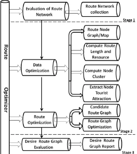
The system framework is subdivided into three stages as shown in figure 1. Stage one; evaluates the existing route and transformed them into data structure store within the system. Stage two; Optimize the data in the storage and used the user input to generate route weight graph and route map, compute route length and resources, compute node cluster, and extract tourist attraction of the goal destination. The Route Optimization extract the candidate route which is all possible route from origin to destination and route graph optimization which is cost of each possible route from origin to destination. Stage 3, evaluate and select the best optimal route with least cost that link the source and the target. The graph generator used this optimal route to generate the graph lead way. Figure 1 shows the System Architectural Conceptual Framework.
ISSN(E): 2277-128X, ISSN(P): 2277-6451, pp. 90-97
IV. REULTS AND DISCUSSION 4.1 Software Execution
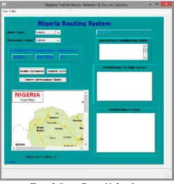
The users locate the software icon on the desktop or in the start button menu list, double click the icon to start the application. The application interface display on the screen as shown in figure 2, at this point, the software is in ready state to accept data from the user via the comboBox.
Figure 2: System Executable Interface
The system accept a pair of data (Origin and Destination state) from the user and wait for the user to specified from the command button which operation to carried out. The system have seven output interface which include Fuel Needed, Travelling time, Distance in Kilometer, Destination neighboring State, Destination Tourism Center, Destination Lodges and a map viewer window. The system used operation button choose by the user to compute the resulting output and display it on the screen either in apple view or in the TextArea of the system interface output section base on the user selected the Origin and Destination state.
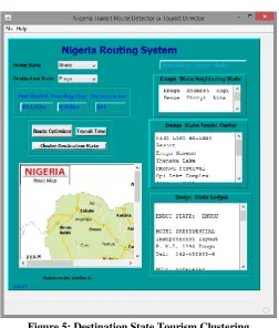
Figure 3 and figure 4 show the execution optimizing Rivers State and Enugu State while figure 5 shows destination state tourism clustering.
ISSN(E): 2277-128X, ISSN(P): 2277-6451, pp. 90-97
Figure 4: Optima Route
Figure 5: Destination State Tourism Clustering
4.2 Discussion of Result
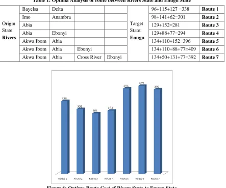
The system optimize the best route from Home State to Destination state by considering the least shortest distance in kilometre after detail evaluation of all possible route from Origin to Destination state extracted by system and plot the graph of the best shorted route.
ISSN(E): 2277-128X, ISSN(P): 2277-6451, pp. 90-97
Table 1: Optima Analysis of route between Rivers State and Enugu State
Figure 6: Optima Route Cost of Rivers State to Enugu State
V. CONCLUSION
Tourism is built for recreation effect for mankind, it need proper utilization by the operator and the beneficially. The beneficially need to know the various location of these rich attractive centres of their vacation domain. Tourism is capable of improving our economic incentive by generating employment, taxes, refresh life, create amusement in citizen life etc.
Best route optimization is the secret key behind to open door to a successful road transit. Route optimization is as old as ageist, all lives activities is surrounded by movement, man aim at getting the shortest path to his target point with easy. Man desire to use the best shortest smart route in all lives activities, which is the act of optimization.
This paper will certainly make a tremendous impart to humanity in the area of tourism, transport management and the field of optimization. It has removed the difficulties in interpreting road map on paper for traveler. It is have made it possible for anybody to travel within Nigeria without asking question. This software can be embedded into car for route navigation such that the system reviews the route to the driver as the car move from location to location within Nigeria. The system also solves the problem of need such as amount of petrol needed to make a journey. This work has made it known that Heuristic graph and adaptive routing can model an intelligent route optimization.
REFERENCES
[1] B. V. Cherkassky, A. V. Goldberg, and T. Radzik, "Shortest Paths Algorithms: Theory and Experimental
Evaluation". Mathematical Programming, (1996), Ser. A 73 (2), pp. 129–174. doi:10.1016/0025-5610(95)00021-6.MR 1392160.
[2] M. F. Qureshi, S. M. Ali Shah, G. I. G. Al-Matroushi, “A Comparative Analysis Of Multi-Criteria Road
Network”, European Journal of Computer Science and Information Technology, 2013,Vol.1, No.2, pp27-47.
[3] E. Avineri, “Soft Computing Applications in Traffic and Transport Systems- A Review”. Soft Comput.:
Methodol. Appl. Adv. Soft Comput. 2005, 32, pp. 17–25.
[4] S. K. Sanjiv and A. Anupam, “Present and Future Perspective On Optimization Of Road Network
Management”, International Journal of Computer Trends and Technology (IJCTT) –2015, volume 22 Number 2. Origin
State: Rivers
Bayelsa Delta
Target State: Enugu
96+115+127 =338 Route 1
Imo Anambra 98+141+62=301 Route 2
Abia 129+152=281 Route 3
Abia Ebonyi 129+88+77=294 Route 4
Akwa Ibom Abia 134+110+152=396 Route 5
Akwa Ibom Abia Ebonyi 134+110+88+77=409 Route 6
ISSN(E): 2277-128X, ISSN(P): 2277-6451, pp. 90-97
[5] H. C. Nsonwu, “Determining Optimal Route Using Geographical Information System : A Case Study Of
Bonny-Bomu Road In Rivers State”, Nigerian institution of Surveyors, 2010, 45th
Annual General Meeting and Conference, Pp. 78 -87.
[6] J. O. Royset and H. Sato, “Route Optimization for Multiple Searchers”, Operations Research Department, 2009,
Naval Postgraduate School Monterey, California, USA.
[7] L. N. Spasovic, M. P. Boile and A. K. Bladikas, “A Methodological Framework for Optimizing Bus Transit Service Coverage”, Transportation Research Record, 1993.
[8] M. Wooldridge, “An introduction to Multi-Agent Systems”. 2002, John Wiley and Sons Ltd..
[9] A. Abraham, D. Jarvis, J. Jarvis, J., and L. Jain, “Innovations in intelligent agent technology”, Multiage Grid
Syst., 2008, 4 (4), pp. 347–349.
[10] M. Dorigo, V. Meniezzo and A. Colorni, “Ant System Optimization by a Colony of Cooperating Agents”, IEEE
Transaction on Systems, Man and Cybernetics, Part B, 1996, vol. 26 No. 1, pp. 225-230.
[11] E. Bonabeau, M. Dorigo, and G. Theraulaz, “Swarm Intelligence: From Natural to Artificial Systems”. Oxford
University Press, 1999.
[12] D. Teodorovic, “Swarm Intelligence Systems for Transportation Engineering: Principles And Applications”,
Transport. Res. Part C: Emer. Technol. , 2008, 16 (6), pp. 651–667.
[13] K. R. .C. Eberhart, “Particle Swarm Optimization”, in Proceedings of the IEEE International Conference on Neural Networks, 1995, pp.1942-1948.
[14] A. W. Mohemmed, N. C. Sahoo, and T. K. Geok, “Solving Shortest Path Problem Using Particle Swarm
Optimization”, J. Elsevier, Applied Soft Computing,, 2008, pp. 1643- 1653.
[15] S. Han and Y. Tabata, “A Hybrid Genetic Algorithm for the Vehicle Routing Problem with Controlling Lethal