Journal of Information Technology and Computer Science Volume 4, Number 1, June 2019, pp. 57-63
Journal Homepage: www.jitecs.ub.ac.id
Open Source Geospatial Solution for Disseminating Green
Park Information
Arati Paul1, Rabi Sankar Mondal2, Debasish Chakraborty1, 1 Regional Remote Sensing Centre – East, ISRO, Kolkata, India
2 Dept. of CSE, GCECT, Kolkata, India
{1[email protected], 2[email protected], 3[email protected]}
Received 12 February 2019; accepted 13 June 2019
Abstract. Green parks and open spaces are indispensable parts of an urban environment as they play important roles in promoting public health, protecting natural ecosystems and improving socioeconomic conditions of the city dwellers. Hence, the information of green and open spaces in a city needs to be provided to its governing authority and people for better management and utilisation. Web enabled geographic information system (WebGIS) is capable in maintaining and disseminating green park information among its users over the web. The availability of open source geospatial software and tools made this technology more cost effective. In present study an interactive and user friendly WebGIS is developed for city dwellers and decision makers to search and visualise green parks of Kolkata city both on map and satellite image along with park information and ground photo. It is an easy deployable solution that can help in urban planning for creating new as well as preserving the existing green spaces.
Keywords. Green parks, Information system, open source, GIS, WebGIS, Kolkata.
1
Introduction
In today’s world urban spaces are growing very fast to support different human activities. However, a healthy and liveable city is more than just building and people. Green parks and open spaces are indispensable parts of an urban environment as they play important roles in promoting sports and recreation activities, preserving natural environment and improving social and economic conditions of the city dwellers. Hence governing authority of a city and its people need to have an easy access to the information of its surrounding green and open spaces to maintain and preserve them and get benefit out of them.
58 JITeCS Volume 4, Number 1, June 2019, pp 57-63 However, a full version of Geographic Information System (GIS) is not always desirable due to its technical and financial constraints. Additionally, to make the benefits of GIS reach to all of its stake holders in a customized form, the geo-spatial information needs to be disseminated through web. In recent years Web enabled GIS (WebGIS) is enabling user community to meet their geospatial requirements in many fields [4-8]. The availability of open source geospatial software and tools made them more popular in providing cost effective geospatial solutions [9-11]. In addition to the cost benefit, open source solution ensures certain other advantages too [12]. As the source is open, the software/ tool can be customized/ modified to develop a more secure solution which is hardly possible in any proprietary/ commercial off-the-shelf (cots) software/ products. The strong and wide spread open source developer community enables to receive frequent updates, which is not always possible for proprietary items because of its company dependency. This developer community also helps in reducing the application development time by sharing their rich experiences and expertise in respective areas. Hence, the web enabled open source geospatial technologies are advantageous to be adopted to disseminate the geospatial information to large number of users for their benefit.
Kolkata, the capital of state West Bengal, is one of the densely populated cities in India [13] and is still growing. Hence, building a geospatial solution for green and open spaces of the Kolkata city is very relevant and beneficial. In present study a WebGIS solution is developed to disseminate information of green parks including population and park area located in Kolkata city.
2 Study area
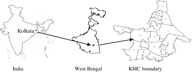
The Kolkata Municipal Corporation (KMC) area is a part of the Kolkata city that comprises of 15 boroughs and 141 wards. It is spread over 185 km2 [14] on the east bank of Hoogly river. In present study the KMC area is taken for the development of the WebGIS solution. The index map of the study area is shown in Fig. 1.
Fig. 1. Index map of KMC divided into 15 boroughs.
3 Data used
In the present study both spatial and aspatial data is used. Spatial data includes park location, ward boundary, borough boundary and geo-referenced satellite image. Park name, address, postal index number (PIN), park area, ward wise population etc. comes under aspatial information. Geo-tagged ground photographs are included in the application for visualisation of facilities available in the park. Web map services
Kolkata
Paul,et al, Open Source Geospatial Solution: ...59
(WMS) of Bbhuvan [15] are consumed in the present application for map and satellite image visualisation over the web.
4 Application architecture
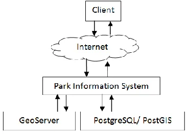
The application is conceptualised as three tier architecture. The first tier is the Client (or browser), second tier is the application. The third tier includes the GIS server (GeoServer) and the database server (PostgreSQL/ PostGIS). The system architecture is shown in Fig. 2. Apache web server is used in application server [20] to access the client requests through Hyper Text Transfer Protocol (HTTP). Apache is proposed as the web server, because it is the most popular operating system independent php (Hypertext Preprocessor) developer package. The client requests are analysed in the application server and subsequently the requests are passed to either/ both the GIS server or/and database server. On successful receipt of reply from the GIS server or/and database server(s) the customized result is sent back to the client by the application server through HTTP.
Fig. 2. Architecture diagram of the WebGIS solution
60 JITeCS Volume 4, Number 1, June 2019, pp 57-63
5 Methodology
The overall methodology is broadly divided into (i) data preparation, (ii) creation of database and web services and (iii) development of application. Following sections describes them.
5.1 Data preparation
The park location and boundary, collected using Global Positioning System (GPS), are converted into spatial layers using QGIS [21] software. The information of ground photographs, park name, address, PIN code, ward, borough, park area and ward wise population are integrated with the respective spatial layers.
5.2 Creation of database and web services.
The spatial database is created in PostgreSQL/PostGIS database [17-18] and all the layers are stored into it. Each data layers stored in the database are converted into WMS using GeoServer [16] and shared over Internet.
5.3 Development of the application
Finally, the WebGIS application is developed using HTML and Java scripts. Open Layer [22] is used to develop GIS functionalities. PHP [19] is used to access data from the database server. Customised dynamic web pages are developed with the help of AJAX [23] and JQUERY [24].
6 Application interfaces
The Kolkata park application aims to help city dwellers in getting benefit of green spaces by showing the geographical distribution of green parks in their neighbourhood with associated information. The application also intends to facilitate city administrator for decision making towards green space creation and conservation by providing ward and borrow wise population and green space statistics. Hence, an interactive user friendly application interface is developed as the targeted users are mostly of non-GIS background.
Paul,et al, Open Source Geospatial Solution: ...61
Fig. 3. Parks categorised into different sizes overlaid on map.
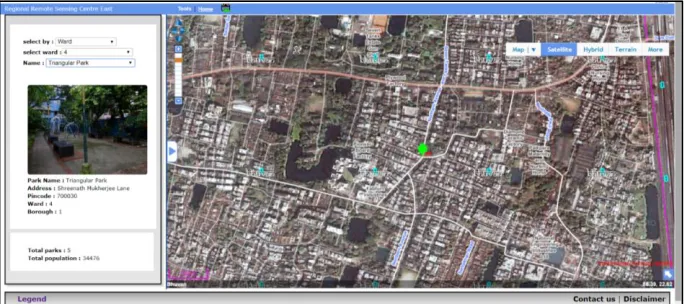
The application includes tools viz. zoom in/out, zoom to full extent, selective zoom, re-centre and pan for map navigation. It allows user to measure distance and area on the map by respective tools. The application enables user to search and visualise parks located in a specified ward/ borough / PIN code area. Parks can also be searched by name. On completion of the search the parks details are shown along with population and park statistics which is a very crucial information for decision makers. Fig. 4 shows the details of a selected park overlaid on satellite image with statistics for the selected ward number.
Fig. 4. A park on satellite image with aspatial information, photo and statistics
7 Discussion and future scope
62 JITeCS Volume 4, Number 1, June 2019, pp 57-63
8 Conclusion
The park application will help city dwellers by visualising park data of Kolkata city in web environment. It maintains the inventory of parks and provide green spaces versus population statistics. This in turn helps in urban planning towards creating new green spaces and conserving the existing ones in the city.
Acknowledgments. Authors acknowledge Ms Mallika Jalan, Secretary, Centre for Contemporary Communication, Kolkata for providing park location data, along with its attributes, for developing the application. Authors also acknowledge Dr. D. Dutta and Mr. G. S. Rao, former General Managers of RRSC-East, for their encouragement towards the present work.
References
1. Blodgett, D., Booth, N., Kunicki, T., Walker, J., Lucido, J. (2012). Description of the US Geological Survey Geo Data Portal Data Integration Framework. Selected Topics in Applied Earth Observations and Remote Sensing IEEE J. 5 (6), 1687-1691.
2. Cau, P., Manca, S., Soru, C., Muroni, D., Gorgan, D., Bacu, V., Giuliani, G., (2013). An interoperable, GIS-oriented, information and support system for water resources management. Int. J. Adv. Comp. Sci. Appl. 3 (3), 75-82. http:// dx.doi.org/10.14569/ SpecialIssue.2013. 030309.
3. Paul A., D. Chakraborty, D. Dutta, P. K. Das, M. Jalan, S. Chettri, N. Shrestha, S. Menon, (2016). Park information system for Kolkata- A low cost web enabled solution, Journal of current trends in information technology , 6(1), 1-5
4. Zhang, Y. and Barten, P.K. (2009). Watershed Forest Management Information System. Environmental Modelling & Software, 24, 569-575. http://dx.doi.org/10.1016/j.envsoft. 2008.10.006
5. Sarup J. and Shukla V. (2012). “Web-Based solution for Mapping Application using Open-Source Software Server”, International Journal of Informatics and Communication Technology, 11 (2), 91-99.
6. Singh P.S., Chutia D. and Sudhakar S. (2012). “Development of a Web Based GIS Application for Spatial Natural Resources Information System Using Effective Open Source Software and Standards”, Journal of Geographic Information System, 4, 261-266.
7. Paul A., Chowdary V. M., Chakraborty D., Dutta D., Sharma J. R. (2014). “Customization of freeware GIS software for management of natural resources data for developmental planning - A case study”, International Journal of Open Information Technologies, 2(4), 25-29. 8. Chakraborty D., A. Paul, D. Dutta, A. Jayaram, T.P. G. Kumar, A. Bajpai, Khusboo Mirza,
V. Soni and D. Thirani, (2016). IndianTea Garden Information System- A WebGIS Enabled Solution, Asian Journal of Geoinformatics, 16 (1), 8-16.
9. Aher P.D., Adinarayana J., Gorantiwar S.D., Sawant S.A. (2014) Information System for Integrated Watershed Management Using Remote Sensing and GIS, Remote Sensing Applications in Environmental Research. DOI: 10.1007/978-3-319-05906-8_2.
10.Gobakisa K., A. Mavrigiannakia, K. Kalaitzakisb, D.-D. Kolokotsaa, (2017). Design and development of a Web based GIS platform for zero energy settlements monitoring, Energy Procedia, 134, 48–60, 10.1016/j.egypro.2017.09.598.
11.Mondal R. S., D. Chakraborty, A. Paul and K. D. Dafadar. (2018). WebGIS Enabled Facility Mapping and Identification - A Cost Effective Solution, International Journal of Computer Applications 180(38), 41-44. DOI: 10.5120/ijca2018917019
12.Opensource, (2018). https://opensource.com/resources/what-open-source 13.Census, (2011). from www.census2011.co.in
Paul,et al, Open Source Geospatial Solution: ...63
15.Bhuvan, (2018). from: www.bhuvan.nrsc.gov.in 16.Geoserver, (2018). from: http://geoserver.org 17.PostgreSQL, (2018). from: www.postgresql.org 18.PostGIS, (2018). from: http://postgis.refractions.net/ 19.PHP, (2018). from: https://www.php.net
20.Apache, (2018). from: http://www.apache.org/ 21.QGIS, (2018). from: https://qgis.org/