© by the author(s) Licensed under Creative Commons Attribution 3.0 License
Assessment of spatial reference points
and spatial relations in indoor
environments for orientation tasks
from natural language descriptions
Cristiane Kutianski Marchi Fagundes
1, Rhaíssa Viana Sarot
1, and
Luciene Stamato Delazari
11Department of Geomatics, Federal University of Paraná, Curitiba, Paraná, Brazil
Received: ; revised:; accepted: ; published: .
Abstract: Spatial Relations and Spatial Reference Points have been studied for decades in the areas of cognition, geography, computer science, geosciences and recently, in robotics and artificial intelligence. Moreover, the process of orientation and navigation in outdoor and indoor environments requires a thorough study with Spatial Relations and Spatial Reference Points. However, there are experiments performed with computational resources, by means of simulations or illustrations. Considering this, the objective of this research was the realization of experiments in natural language that considered the human spatial orientation used in tasks performed in people’s daily routine in indoor environments. Furthermore, it will contribute to the studies that have considered descriptions of everyday environments performed in daily natural language. The methodology consisted of collecting descriptions that were used to the indoor environment in real routine. Finally, the descriptions were analysed and provided the classification of spatial reference points and spatial relations most expressive in the Brazilian Portuguese language. Thus, these results contributed to the understanding of the process of user’s spatial orientation, especially in indoor environments.
natural language.
1
Introduction
Spatial relations [40,7,6] and spatial reference points (SRP) [25,39] have been studied for decades in the areas of cognition, geography, computer science, and geosciences. More recently, due to computational development, these concepts have been studied in other areas, such as robotics and artificial intelligence [22,18,34].
The literature about spatial information shows that to communicate a spatial information people have to use spatial relations, which describe how an object, an image, or a person (locatum) are located in space relative to another object, image, person or reference point (relatum) [8,43]. Thus, in order to locate an object, image or a person in space, they must be placed relative to reference points (relatum). In geographic information systems, the spatial relations assessed are topological [3]. However, it is important to note that spatial relations surpass purely mathematical aspects since there are several other ways of representing and utilizing them in everyday life. Spatial relations should be considered applicable to real-world problems, taking into account linguistic and cognitive aspects [14].
In contrast, theories of spatial reference points (SRP) and landmarks, in turn, are recognized when relating information newly received from the environment with previous knowledge about the place [25,37,36]. They are elements that differentiate characteristics in an environment and, therefore, stand out from other elements present in the surroundings [25,9,29,44,42,37].
There are researches in cartography and geography areas that are concerned with identifying which geographical features and spatial reference points (SRP) are used in the process of orientation and navigation. Meanwhile, researches in areas of cognition, psychology, and linguistics have demonstrated how humans perceive spatial relations through these geographical features and these reference points. However, these studies have approached spatial relations and reference points not analyzing the location descriptions in natural language in indoor environments [14,26].
Finally, especially in the case of reference points, many studies also do not consider the specificity of indoor environments, being extensively addressed in outdoor environments instead [25,35,39,20,21].
Additionally, performing such study through the perception of the people themselves would significantly contribute to the process of spatial orientation and navigation studies in indoor environments. After all, indoor environments contain a large number of constraints and information, such as the presence of multiple floors or frequent changes in the layout of objects, which can lead to the loss of orientation and spatial navigation of people [17,5,30].
points, which ones have attributes or physical characteristics that might make them landmarks. Furthermore, which are the most expressive spatial relations used and described by people in natural language in everyday routine. This type of study could contribute to people spatial orientation in indoor environments.
Considering these aspects we present a study performed through experiments with people in everyday physical spaces without employing computer simulations, with the goal of identifying which elements people use as spatial reference points (SRP), which spatial reference points could be a landmark to contribute to the understanding of the people’s spatial orientation in indoor environments. Moreover, which are the most expressive spatial relations that describe a location in indoor environments configuration. The approach of this research will contribute to the studies that have considered descriptions of everyday environments performed in natural language. Furthermore, the present study considered the analysis of these aspects in two types of indoor environments: one in the educational context (Building I), and another in the administrative context (Building II). Descriptions were collected and analysed in Brazilian Portuguese natural language.
Initial results indicate a preference for spatial relations "at, on, in" and four different terms of spatial relations emerged from the descriptions. Moreover, results point out some possible landmarks, some Points of Interest in the indoor environment and elements that possibly could help the process of spatial orientation in the representations of indoor environments.
2
Literature Review
The literature about spatial orientation of people relies on their knowledge about the environment, since they establish their position based on the elements identified in the place [37,36]. The cognitive processes responsible for acquiring, encoding, storing, retrieving, and manipulating spatial information allow people to interpret environment relations and utilize them to establish their own position. Thus, the process of spatial orientation is directly related to people’s mental representation [28,24,27,37].
awareness, because they are elements that structure the mental images of the space. These specific objects are called spatial reference landmarks [39].
In indoor environments, spatial reference landmarks have the main function of providing information about the point where decisions must be made in relation to a route or even, demarcating the point where the orientation of the navigator changes direction [41]. The classification of reference landmarks is based on the function they perform in the environment; visual landmarks are objects whose characteristics contrast with their surroundings, that is, whose visual characteristics make them perceptible and memorable. Cognitive landmarks are objects that contain a cultural or historical meaning, and they stand out because their content contrasts with other elements present in the same environment. Finally, structural landmarks are spaces, intersections or aspects of the environment that can be considered a reference point due to where they are located [39].
Also, in indoor environments, bathrooms can be considered cognitive landmarks, due to their practical implication. Stairs, elevators, entrance doors, commercial areas, and libraries may be considered as potential visual and structural landmarks. Stairs and elevators, for example, are decision-making points, since they are intersections that allow individuals to change direction and orientation inside the environment (in this case, alternating floors) [38,36,1].
Another category that should also be considered in the analysis of spatial reference points (SRP) is Point of Interest (POI), which assists people in the execution of a task or a specific interest. However, the use of POI as spatial reference depends on the particular context of people, it is because one certain POI can be considered irrelevant for ones and relevant for others in the same environment [34,15].
Spatial information also is understood and transmitted through the use of spatial relations that describe how an object in some environment is located (locatum) relative to some other object or spatial reference point (relatum). Furthermore, spatial relations have been studied in different disciplines, including computer science, geographic information science, cognitive and linguistic science. Within these disciplines, spatial relations are generally considered appropriate for one of three categories: topological (overlaps and separations), directional (above, below, right and left) and distance (near and far) [43]. Additionally, spatial relations in any natural language have a limited number of words [33].
Through experiments in natural language, it is possible to collect information about the process of spatial orientation of people in indoor environments, since spatial reference points (SRP) and spatial relations can be identified in the descriptions of locations. These experiments are also useful to determine the level of relevance of a particular reference point in relation to the usage context and structure of the environment in which it is located, since buildings designed to develop different contexts have different spatial reference points (SRP) [26,36,1,2].
3
Methodology
To identify which spatial reference points (SRP) and potential reference landmarks contribute to the understanding of the user’s spatial orientation in indoor environments, and which are the most expressive spatial relations that describe a location in indoor environments configuration, this study was performed through experiments with users in everyday physical spaces. Furthermore, the present study considered the analysis of these aspects in two types of indoor environments: one in the educational context (Building I), and another in the administrative context (Building II). Descriptions were collected and analysed in the Brazilian Portuguese natural language.
3.1
Participants
The authors have decided by users that had familiarity both with the study area, located at Campus Centro Politécnico (Federal University of Paraná) and the internal structure of the buildings, since their cognitive maps are more structured in comparison to individuals who do not know the environment [36,1,2]. Furthermore, users were either undergraduate students of the Cartographic Engineering or graduate students of the Geodesic Sciences course and they had familiarity with the internal structure of the buildings. Tasks were realized by 33 users, all native speakers of Brazilian Portuguese, who voluntarily participated in the experiment and their ages ranged between 19 and 42.
3.2
Study Design
The experiment conducted in the present research, in turn, approached the level of familiarity of the users with the indoor environment, and sought to identify in them the spatial reference points, landmarks, and the most expressive spatial relations. The collection of verbal descriptions made by on-site users and the analysis of these descriptions, based on the most used locative expressions, provided spatial reference points, landmarks, non-spatial attributes that aid the orientation process, and the spatial relations utilized in indoor environments.
of indoor maps, and with the studied indoor environment. Furthermore, the search for specific places in the maps and with the collection of descriptions in natural language for extraction of spatial relations [13, 37, 41, 36, 1, 2, 12].
The experiment was divided into two stages. In Stage 1, users filled in an online questionnaire, assembled via Google Forms, which contained three parts. The first part consisted of the experiment’s consent form; the second part referred to the identification and characterization of users (name, age, gender, level of education); the third part contained questions about the architecture of the buildings, how frequently users visited them and the areas they most commonly visited, as well as questions about their level of confidence in providing information about the buildings to others and their level of familiarity with the buildings. During this stage, the users also authorized the recording of their location descriptions for two positions, one verbal description to Building I and another to Building II. Instructions and descriptions were in Brazilian Portuguese, incited by the question: “Onde você está localizado dentro deste Campus?” (“Where are you located inside this Campus?”).
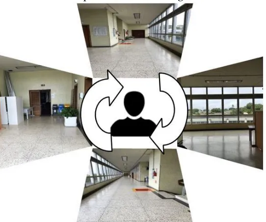
In Stage 2, researchers have chosen two buildings to realize the experiment. Buildings are located at the Campus Centro Politécnico of the Federal University of Paraná (Figure 1). Both buildings have multiple floors and structural divisions considered convoluted by non-familiarized individuals, as well as having a wide information and place variety (classrooms, laboratories, common living areas, commercial establishments, departments, auditoriums, libraries, bathrooms, etc.). The Building I was designed for educational use, while Building II was designed for administrative use.
Figure 1 - Localization map of Building I and II in Campus Centro Politécnico of the Federal University of Paraná in Brazil
location (Position B) was the corridor of the Noble Hall on the second floor of the Administration department (Figure 3).
FIGURE 2 – POSITION A in the ground floor corridor in the Mechanical Engineering department in Building I
FIGURE 3 – POSITION B in the corridor of the Noble Hall on the second floor of Building II
to make the users observe the environment they were positioned in. The users were free to describe the location as they wanted to look for elements to describe in any side of the corridors. This way, users could describe their location indicating the spatial reference points (SRP) and the spatial relations they considered relevant in each position.
The answers were recorded on the spot, so that the accuracy provided by natural language was not lost. If answers had been written, a risk of losing relevant details in the language would be present, since they demand a certain time to be annotated. The recording also allows the description to be fluid and natural, as it occurs during any process of descriptions in natural language. In the end, the audios were stored and named in order to be linked with the questionnaire from Stage 1.
After the recordings were collected, the data processing started with the transcription of verbal descriptions into an Excel spreadsheet. Then we distributed the descriptions into locative expressions, which contained at least one spatial relation between two or more reference points [19,23]. The locative expressions elements collected were added on columns in the Excel spreadsheet in order to enable the understanding and analysis of the data. In the analysis of spatial relations, expressions that were not locative were discarded, while in the analysis of reference points all expressions were considered so that no remark was lost.
The descriptions collected provided the identification of the most commonly used spatial relations, and which elements in indoor environments were considered as spatial reference points and as landmarks. The descriptions mentioned spatial relations between two reference points and/or often between the subjects themselves and the reference points. The steps taken in this analysis are described below.
3.2.1 Spatial Relations
Spatial relations were extracted from the descriptions into locative expressions, as the following example illustrates:
Description of Position A – “Estou próximo à cantina interna dos blocos, em frente à porta do Departamento de Mecânica e da Coordenação do Curso de Engenharia Mecânica”. (“I am next to the indoor cafeteria of the blocks, in front of the door of the Department of Mechanics and the Coordination of the Mechanical Engineering course.”).
a) Estou próximo à cantina interna dos blocos. (I am next to the indoor cafeteria of the blocks.).
b) Estou em frente à porta do Departamento de Mecânica. (I am in front of the door of the Department of Mechanics.)
The analysis resulted in a table (Table 1) containing the spatial relations which users used to describe their position. In this table, the spatial relations were not separated by environment, but instead considered altogether.
3.2.2 Spatial Reference Points
It was considered that the spatial reference points should vary according to the context of the use of the building. Thus, the results obtained in both positions A and B cannot be grouped.
In the first step, the described words and their meanings were analyzed. Then, all the words mentioned which are related to elements that refer to spatial orientation points in both environments were separated and grouped into two 8-column tables (Table 2 – Building I Educational Use and Table 3 – Building II Administrative Use):
1. Classification of Indoor space use;
2. Elements mentioned as a spatial reference point;
3. Synonyms of elements mentioned as spatial reference points; 4. Number of times that the elements were mentioned;
5. Spatial and non-spatial attributes of the elements;
6. Number of times the elements were mentioned with attributes; 7. Physical characteristics of the elements (material or/and color);
8. Number of times the elements were mentioned with physical characteristics. The spatial attributes mentioned in item 5 are specified as follows:
a) Positioning on the site: contains specific elements that are used to establish a position in the building (internal or external).
b) Floor number: corresponds to the number of the floor in the building (ground floor, first, second, etc.);
c) Block number: corresponds to the block number in which the building is inserted (each block is composed of one or more buildings, which contain similar characteristics).
The non-spatial attributes in item 5 mentioned are specified as follows: d) Genre: corresponds to the restroom’s doors;
e) Room name: classrooms names (geology, mechanics, civil, employees room); f) Course name: presents which are the Institute responsible for the management
and administration of certain courses within the buildings (Mechanics and Civil Coordination, Geology Department);
g) Official Name: official identification method used to name a certain space (administration, departments, buildings, labels);
h) Type of the element: large, empty, main.
3.2.3 Maps
in each context of the indoor environment. Moreover, the subjects were free to use the spatial relations they think in their minds.
The architectural plans of the two floors of this building were updated by means of topographic and cadastral data collection, in order to design the maps of Position A and B. Maps were designed on QGIS following the descriptions and the classification of Indoor space use (common use area, bathroom, movement of people, education, objects, professors rooms, transition level, administrative use, commercial use, building, outdoor) for both positions [1,36]. Moreover, maps were designed to analyse if elements were mentioned as a cognitive, visual and structural spatial reference point.
4
Results and Analyses
The process resulted in 66 descriptions for positions A and B. The assessment of the results was performed by comparing the data obtained by the analysis described in the previous section. In the case of spatial relations, the data obtained in the two study areas were grouped to be accounted for at one time. In the case of spatial reference points, the context of the use of buildings (educational and administrative) was considered.
4.1
Spatial Relations
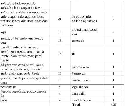
As a result, 475 occurrences of spatial relations grouped in 30 groups (Table 1) were extracted from the total of locative expressions used in the descriptions. Table is in Brazilian Portuguese in order to not compromise the analysis.
Groups of spatial relations Occurrence Groups of spatial
relations Occurrence
no,nos,na,num, numa, em um,
em, em que 98 daqui 3
tem, existe, existem 67 ao fundo, ao fim 3
na frente, na frente
do/da/das/desta, em frente, em frente à/ao/aos, de frente para/pra
61 com 2
próxima à, próximo, próximo a/as/ao/da/de/do, logo próximo à, perto da/das/do/dos/de, bem perto de
58 antes da,
pouquinho antes da 2 à direita, à/na direita tem, lado
direito, do/pro lado direito, ao/do lado direito tem, nas costas tem do lado direito, esquerda, à esquerda, à/na esquerda tem,
ao/do/pro lado esquerdo, ao/do/no lado esquerdo tem ao/do lado da/de/do/dessa, deste lado daqui onde, aqui do lado, um dos lados, dos dois lados das, na lateral
21 do outro lado,
do lado oposto da 2
aqui 18 pra trás, nas costas
tem 2
aonde, onde, onde tem, aonde
tem 18 acima da 1
para/à frente, à frente tem, bem/logo à frente, um pouco à frente, para frente, mais para frente
16 ali 1
dá para ver, consigo ver, onde
posso ver, pode ver, eu vejo 11 dá acesso ao 1
atrás, atrás tem, atrás da/de 10 dentro do 1
que dá, que dá para/pra, que dão
para 7 desde ... até ... 1
nesse/neste 5 logo abaixo 1
depois, depois da, pouco depois
da 4 para baixo 1
entre 4 uns 10 metros 1
Total 475
Table 1 – Total of spatial relations
4.2
Spatial Reference Points
Any potential conflicts of interest should be clearly acknowledged in the covering letter. Any financial contributions or support for the work being reported should be listed in the manuscript acknowledgments.
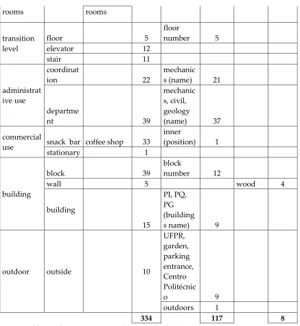
Descriptions resulted in 678 occurrences of elements mentioned as spatial reference points, thus 334 elements to Position A (Educational indoor environment) and 344 elements for Position B (Administrative indoor environment).
The classification of indoor space use of Tables 2 and 3 shows the groups where
elements mentioned were inserted: common use area, bathroom, movement of people, education, objects, professors’ rooms, transition level, administrative use, commercial use, building and outdoor.
1-Classificati on of Indoor Space Use 2 - Elements mentione d as a spatial reference point 3 - Synonyms of elements mentioned as spatial reference points 4-Numb er of times 5 - Spatial and non-spatial attributes 6-Number of times with attribut es 7 - Physical characte ristics (materia l and color) 8-Numb er of times with physic al charact eristics common
use area library 1
bathroom bathroom 3
ladies
(genre) 2
movement of people corridor place of grater flow of people 34 begin, end, backgrou nd, lateral, middle
(position) 16
main
(type) 2
door
input / output, third, closed,
snack bar 29
education
laborator y
COEM JR, electrochemi
stry 4
classroom
, room 3
geology
(name) 2
objects
bench 10
public notice
informative board, panel,
mural 22
metal,
green 4
dumpster
s 2
sign Plate content 13
fire
hydrant 3
rooms rooms
transition level
floor 5
floor
number 5
elevator 12
stair 11
administrat ive use
coordinat
ion 22
mechanic
s (name) 21
departme
nt 39
mechanic s, civil, geology
(name) 37
commercial
use snack bar coffee shop 33
inner
(position) 1
stationary 1
building
block 39
block
number 12
wall 5 wood 4
building
15
PI, PQ, PG (building
s name) 9
outdoor outside
10
UFPR, garden, parking entrance, Centro Politécnic
o 9
outdoors 1
334 117 8
Table 2 - Elements mentioned as spatial reference points (position A)
1-Classificati on of Indoor Space Use 2 - Elements mentione d as a spatial reference point 3 - Synonyms of elements mentioned as spatial reference points 4-Numb er of times
5 - Spatial and non-spatial attributes 6-Numbe r of times with attribut es 7 - Physical characte ristics (materia l or/and color) 8-Numb er of times with physic al charact eristics common use area auditoriu m noble hall,
hall 36
library 14
science and technolog
y (name) 1
bathroom bathroom 2
movement of people corridor 22 end, middle
(position) 8
long, giant, large, empty, wide, main
(type) 8
elevator hall
open space, larger
entrance 5
footbridg
e
access,
corridor 11 glass 1
door 24 double, single, large (type),
main 7 wood
10
pantry
(name) 2
objects
rack,
plant pot 3
extinguis her
sign 2
label of the sign
(name) 1
window 6
professors’
rooms office 1
transition level
floor 48
floor
numbers 45
elevator 30
stair 21
administrat ive use
departme
nt 27
administr ation
(name) 27
rooms 9
employee
s (name) 1
building
block
III, IV (name
of the block) 37
building 35
tallest, large
(type) 4
left corner
(position) 1
outdoor
Centro Politécnic
o 6
University
, BR 6
344 111 11
Table 3 - elements mentioned as spatial reference points (position B)
Position B resulted in 29 different elements and their synonyms that users mentioned as spatial reference points (SRP). In this position were mentioned rack and plant pot as not fixed, and Centro Politécnico Campus, University and BR (highway where campus is located) in the external area of Building I.
4.3
Maps
visual. Cognitive elements could not be seen by the users’ position and they know the position of those elements in their minds.
On the maps designed, attributes of the features include names, position, types, material and color. The rooms contain information related to their intended use (e.g. classrooms, offices and laboratories); the bathrooms are classified according to gender (female or male) or users with special needs. Objects such as windows, doors and electrical installations were removed from the map to avoid excess information from hindering the cartographic information process between the user and the representation [11,36]. The colors used in the representation should not indicate different levels of importance. Therefore, the colors used do not contrast with each other and they have similar saturation levels.
The spatial phenomenon to be represented considers the specifications regarding the use of spaces that comprise the indoor environment, this being the information needed for the user orientation process in relation to the mentioned elements.
Maps of the position A and B are presented in the links on the Tables below. Position A represents the educational context of the campus with 11 maps (Table 4), and Position B represents the administrative context with 10 maps (Table 5). Elements are represented by color dots and are located on the maps according to users’ descriptions. The red flag symbol is positions A and B where users were located.
Common use area: Library was mentioned unseen because the user was in position A and correctly remembered where it is located for his/her orientation. Map link:
https://drive.google.com/file/d/1W5XMVYfGZgA2OoMmMvKXC6fU9VTYlxi5/view?u sp=sharing
Bathroom: Bathroom is located in the corridor, although it cannot be seen by the user in position A. And it was classified according to gender (female). Map link:
https://drive.google.com/file/d/11ScJS4rEDX7XEVPnWbwX7cbC08ENyjBb/view?usp=s haring
Movement of people: The mentioned corridor points were in the user's field of view. For some of these points, the users attributed physical characteristics of position (begin, end, back, lateral, middle, main). The coffee shop door cannot be seen and it was remembered by the user. Map link:
https://drive.google.com/file/d/1jEuoS7Zj8Oi6C-EV1O04fiIkdS0npbKt/view?usp=sharing
Education: Points highlighted on the map are in the middle of the corridor and they were cited as access to the classrooms. One of the points described as a laboratory (COEM JR) was mistakenly mentioned as in the electrochemical laboratory, because it is badly signposted (its correct position is upstairs). Map link:
https://drive.google.com/file/d/1thA0ff8ht7hctzGTf8XsE-FrhhxVwl_Q/view?usp=sharing
https://drive.google.com/file/d/1lFfo0H66ye4r2B3mFHMfHyu86iwQOrzh/view?usp=s haring
Offices (professors’ rooms): Points in the corridor to the professors’ room have been mentioned because they have an indicative sign. Only two points were mentioned exactly in the professors’ rooms. Users were positioned near this access corridor, and they could see the offices. Map link:
https://drive.google.com/file/d/1MCXkWv5dtVLTC_SevMXjzc7EUnVNc_Mu/view?us p=sharing
Transition level: All the elements described were in the user's field of view. The floor provides a specific area in the building (this is a 2-floor building). Stair and lift were considered architectural components of the building and they allow people to go up and down the floors of the building. Map link:
https://drive.google.com/file/d/1FfjUGMu5tF9hL_64WsYzTLBvyVo6HYMo/view?usp= sharing
Administrative use: All points located in block IV was in the user's field of view and featured signboards that indicated their position and name. The other points located in blocks III and VI had their position remembered by the user. Map link:
https://drive.google.com/file/d/1LM4DnThaMH6OVUU21F43S6q2Ix1bREBw/view?usp =sharing
Commercial use: From position A the users could see the wooden wall of the coffee shop that differs from the other walls on concrete material. Therefore, on the map, the points related to the coffee shop were grouped in the corner that users had visibility. The map also highlights an isolated point within the coffee shop area, because the user accurately mentioned the position of the coffee shop door. Stationery store is located in another building and it was remembered by the user. Map link:
https://drive.google.com/file/d/1jRF_mm_5JJRVLjc_S7XMl_S__p5XTK5U/view?usp=sh aring
Building: Two users misquoted the name of the building in which they were located. The blocks were mentioned 39 times, and 12 citations were with block number attribute. However, 6 users misquoted the number of Block III and Block IV, the fact decreases the process of user spatial orientation. Wall cited is wood whereas in most of the environment the other walls are concrete. Map link:
https://drive.google.com/file/d/1IQ9czo1J31Sg48XxPQcfhmd-KEPNHNQ0/view?usp=sharing
Outdoor: Elements described as "outside", "outdoors" and "garden" were in the user's field of view. The owner (UFPR) and the name of the land/campus in which the buildings were built (Centro Politécnico) were mentioned too. And parking entrance cannot be seen by the user. Map link:
https://drive.google.com/file/d/1MPXta8uMaHZb0FsDAd-7TS3Q849NMMPc/view?usp=sharing
Common use area: Library mentioned is located on the first floor of the neighbor building and user was positioned on the second floor of the administration building (the walls and roof of the library are visible by user through the window). The auditorium is located at the end of the corridor and it was in the user's field of view and featured signboard that indicated their position and name. Map link:
https://drive.google.com/file/d/1MyedBQ685lpgZU2HghVJUwlrMDvmF2OV/view?us p=sharing
Bathroom: Bathrooms are located next to the auditorium and do not have signboards, being mentioned only 2 times. Map link:
https://drive.google.com/file/d/1KIZbORZBUqRkAb_kU8Sft4bddTOPCSQv/view?usp =sharing
Movement of people: Doors located at the end of both corridors were cited. Often users counted the number of doors to move through the corridors. Bathroom doors were cited 6 times, and the Computer Room 4 times, both are located close to position B, but the name of the rooms was not mentioned. The main door of the administration building mentioned is located on the ground floor and it allows the connection between indoor and outdoor environments (it was not in the user's field of view). Some points in specific spaces of movement were also mentioned, as the hall for the lift and the middle and end of corridors. Another point that was mentioned during the test was the footbridge that is located at ground floor level and it is the link between two buildings, and it serves for movement of people. Users were positioned on the second floor of the administration building and could see the footbridge through the window. Map link:
https://drive.google.com/file/d/1M_fZ4hC-HbSWwJ7xGMNrE1yVd9ZJzpnH/view?usp=sharing
Objects: Map displays all the objects mentioned that were in the environment at the time of the test and were in the user's field of view. Map link:
https://drive.google.com/file/d/1FwU74DSkXvxGnUhgDTnWfBbjBSP3kTrx/view?usp= sharing
Offices (professors’ rooms): One user mistakenly pointed out the place as professors’ office. On this floor, there is only one room considered professors office that is
intended for visiting professors. Map link:
https://drive.google.com/file/d/1fjCRnUz9rQjudWwiCOHFjfJhvGvAlC53/view?usp=sh aring
Transition level: One user mentioned a stair and a lift that are not possible to see (opposite side of the corridor). Stair and lift were considered architectural components of the building and they allow people to go up and down the floors of the building. The floor number of the building was also mentioned (this is a 5-floor building). Map link:
Administrative use: Users have mentioned that the rooms around position B are related to the context of administrative use, but users did not present in the answer certainty due to lack of signage of the building. All users believed that the entire building is linked and there is a single department. Map link:
https://drive.google.com/file/d/1hvmnavY9PRVP_RaCyvuyPAxwoY9bDBNE/view?us p=sharing
Building: Some users remembered the location and name of the blocks sequence and buildings that constitute the entire indoor environment where the study area is located. Map link:
https://drive.google.com/file/d/16SOQRAGfdfsEyDPdSFjWqHyNSduBGnzu/view?usp =sharing
Outdoor: One of the points mentioned is the highway where the campus is located, that is, the user made an orientation outside the campus (BR highway). The name of the land on which the buildings were built (Centro Politécnico) and the Exact Sciences building that were not in the user's field of view were mentioned too. Map link:
https://drive.google.com/file/d/1keZmbj1hYeynSM0tYWED1XWqZZtETPv4/view?usp =sharing
Table 5 – Position B: Results of maps
5
Discussion
5.1
Spatial Relations
The group of spatial relations with 21% of occurrences (98), "no, nos, na, num, numa, em um, em, em que" (in, on, at) shows the preference of users in the descriptions of location in Brazilian Portuguese language to indoor environments. This is also justified because the indoor environment is a delimited environment, where people feel more prone to use those prepositions to express their location. Moreover, the spatial relationship "dentro do" (inside), which was quoted once, could be added to the most cited group, because it is a geographic location located inside the building [4].
Regarding spatial relations in indoor environments, the results of this research differ from the results for outdoor environments, in which the spatial relations group "no, na" (in, on, at) placed second in number of occurrences [12].
Descriptions of outdoor and indoor environments in natural language of Brazilian Portuguese have the tendency by using the same terms of spatial relations, but those terms are used in different preferences and orders. However, this research found four groups of words that were used as spatial relations terms in daily descriptions that are different of common spatial known terms and their classification (topologic, directional or distance). Furthermore, natural language allows users to make combinations of words and/or use words that are similar for them in order to explain their location. First group is the terms “tem, existe, existem” (there is/are). Those words are verbs and they were used in locative sentences very often in this research (14%), showing the existence/location of some elements in the environment that were important to location and orientation of users: “No segundo andar existe uma placa indicando o salão nobre.” (On the second floor there is a sign indicating the noble hall.). The term “existe” (there is) that is synonym of the term “tem” (there is) could be considered spatial relation because they were mentioned by users when they were thinking cognitively in location and orientation themselves in that environment. Moreover, terms of that group could be classified as topologic because the sign indicating the noble hall is contained and it belongs to the second floor.
Second group, the terms “dá para ver, consigo ver, onde posso ver, pode ver, eu vejo” (it is possible to see, I can see, where I can see, you can see, I see) could be classified as
directional: “Eu consigo ver a cantina.” (I can see the coffee shop.) The term “consigo ver” (can see) shows the direction of the element (coffee shop) mentioned and it is in their vision view.
Third group of terms could be classified as directional: “que dá, que dá para/pra, que dão para” (that lead, that lead to). For example, on the sentence “Tem o corredor que dá para a cantina.” (There is the corridor that leads to the coffee shop.) user has mentioned two elements (locatum and relatum) that are located in those places and that are related each other representing one direction. Additionally, users did not use themselves but landmark points to describe the location for orientation.
The last different term found was “com” (with) mentioned twice. It could be classified as topologic when it is used to location and orientation. One example is the sentence: “É um corredor com várias salas, todas portas de madeira.” (It is a corridor with many rooms, all wooden doors.).
First time, the analysis of those four terms shows the false impression that they are not spatial relations, but they are. Those terms were used with Locata and Relata and give notion of location and orientation in environments, like the examples below:
1. “Eu consigo ver a biblioteca.” (I can see the library.). Can be notice that “eu” (I) is the Locatum, “biblioteca” (library) is the Relatum, and the term “consigo ver” (can see) is the spatial relation between them.
Although, the classification of new terms that people use as spatial relation in the Brazilian Portuguese natural language descriptions is on Table 6. This research on spatial relations shows that people in daily routine adopted terms that are not spatial terms.
Spatial relation terms Classes
tem, existe, existem topologic
dá para ver, consigo ver, onde posso ver, pode
ver, eu vejo directional
que dá, que dá para/pra, que dão para directional
com topologic
Table 6 – Classification of spatial relation
Spatial relations in any natural language have a limited number of words, but natural language allows people to use terms that are not spatial in spatial situations making them spatial relations.
5.2
Spatial Reference Points
Map analyses allow verifying whether the position of the elements described by users is in accordance with reality. In addition, it is possible to understand the particularities and constraints of the environment where the elements are inserted. The use context and the architectural components of the buildings directly affect the choice and frequency of use of a given element as a spatial reference point.
When comparing elements that were cited as transition points in both buildings evaluated (floors, elevator, stairs), it was noticed that the frequency of its use was directly related to the structural complexity of building. The fact that the building of administrative use has five floors and the building of educational use has two floors increase the number of navigation possibilities for the user and, consequently, the need to use objects that allow such locomotion between floors, thus the importance of that element increases.
Comparing the two maps showing "Transition level", it could be noted that in Position B, a stair and a lift that were not in the user's field of view were mentioned. In other words, the user's interest in relation to the demand for these elements increased due to the need for walking between building floors. But even though, lifts and stairs are easily recognizable in the building, with memorable visuospatial positions (begin, middle, end of corridors) and are considered important architectural components by allowing the change between floors [38,1,36], they do not have the characteristic of being unique in the indoor environment [25].
The same thing happens with the "Block" and "Building" elements, mentioned in both Buildings (I and II). Although they do not provide a specific position, they have a general location in a set of buildings, and show their structural subdivisions. The "Block" was mentioned 76 times and the "Building" 50 times and were considered spatial attributes that must be linked to the building, because they are necessary for the user in the process of spatial orientation.
Some specific spaces mentioned by the users that allow the navigation in the building also help in their process of spatial orientation. For example, the format of the corridors mentioned in two buildings, helped users to understand the internal structure and establish a reference position within the building.
The mentioned corridor points are located according to the attributes mentioned by users (begin, end, back, lateral, middle, main). Moreover, these attributes make them decision-making points. Other elements linked to the corridors are doors, which allow locomotion between the rooms, mentioned in both positions. Another element is the hall that provides access to the lift, considered a decision-making point between floors, mentioned only in position B by 5 users, possibly because they think that the use of the elevator was necessary to access the floor. Thus, although they did not present characteristics that make them spatial reference points, it is important to emphasize that the corridors, doors and hall influence the spatial orientation of users, and therefore, should be elements considered in the possible representations of the indoor environment.
Another element that allows the movement of people is the footbridge that connects educational buildings with the administrative building. But, unlike the aforementioned elements, footbridge has visuospatial characteristics unlike any other element with the same functionality in the building. Access to the footbridge is only possible from the first floor of the building, it is suspended, its walls are glass and it allows users to see the outside area of the building.
In Building II, ten users mentioned the footbridge even though it was not part of the study area and it was not located on the same floor as the users were positioned. Users were positioned on the second floor of the administration building and they could see the footbridge roof through the window. Thus, its visuospatial characteristics make the footbridge noticeable and memorable in the environment, it has a cognitive significance because it connects two different uses contexts buildings. Footbridge is a unique space in the environment in which users were inserted [39], thus concluding that footbridge is considered a visual, cognitive and structural landmark.
Additionally, the library is located near decision-making points (stairs, hall, footbridge) and it is classified as visual, cognitive and structural landmark.
In Building I (educational use), it is noted that the Coffee Shop was cited 33 times as a spatial reference point. This owes to the use of this room (commercial) to differ the use of other elements found in space, which are intended for activities related to education. Visuospatial features of the coffee shop cooperate with the memorization of its position since this particular room has glass walls to allow visualization of the products available to the consumer. Moreover, some parts of the coffee shop walls are wrapped in wood to differentiate the aesthetics of the place, contrasting with the wall of the other rooms, which are concrete. In addition, the coffee shop is located at the intersection of two main corridors, which also facilitates the memorization of its position. From where the users were positioned, they could see the wooden wall of the coffee shop. Therefore, on the map, the points related to the coffee shop were grouped in the corner that users had visibility. As the coffee shop is not really seen, this point was classified as cognitive, due to its importance and its use by users that make it memorable and contrasting in the internal environment. Additionally, coffee shop was classified as structural because it is located at an intersection where there is a place of greater flow of people. The map also highlights an isolated point within the coffee shop area, because the user accurately mentioned the position of the coffee shop door. All these facts make the coffee shop a cognitive, visual and structural landmark.
The stationery has characteristics similar to coffee shop (commercial use, located at the intersection between others two main corridors, wooden wall covering). This could be considered a possible landmark, but we cannot confirm why it was mentioned by a single user who was in Position A. For this reason, the stationery was classified in the research as POI.
The auditorium is located at the end of the corridor which and the final position of the corridor improves its memorization. The memorable position and functionality of the room differ from the spaces in the building that are in the administrative area. The auditorium had no visual characteristics that distinguished it from other elements. And it was mentioned only after users read its signpost. Thus, the auditorium is classified as POI.
Bathrooms were mentioned in both positions because of their importance for users. Further, it is located near the intersection of corridors where it can be characterized as a decision-making point. The gender of the bathroom was mentioned as a physical characteristic in the position A. But it does not have the characteristic of being unique in the indoor environment [25], because there are several rooms with similar physical characteristics throughout the building. Thus, the researchers classified the bathroom as POI, and associated the non-spatial attribute "gender".
In the case of position B, as the context of the building is administrative, users did not worry to link the names of those responsible for the space to their rooms. They only reported that the rooms were of the administration and assumed that the five floors of the building belonged to the same administrative department. The administration building was cited 27 times, with 9 mentions of rooms with administrative functionality, without specifying who is responsible for the area. Thus, considering that the level of importance in the use of the Department and Coordination elements changes in relation to the context of the buildings, it is believed that both elements are POIs.
The same can be considered true for classrooms, labs, and offices that depend on the context of use in which the user is inserted to be noticed. In position A, offices have been mentioned 18 times because their functionality is not directly linked to educational use, as in the case of classrooms (3) and laboratories (4). And in Position B, was mentioned once, because the user knows that the building has an administrative context, then they probably don't believe it has a specific office area.
Users observed local signposts to indicate classrooms, laboratories, and offices. And in some cases, because the location is not well signposted, users have misquoted their room positions. That is, without the signage users would not be able to distinguish these rooms from the others in the building, which shows the need to link the non-spatial attribute of naming to these environments. Thus, classrooms, laboratories and offices are POIs.
Although the signs not considered as reference points and they are objects that can be removed or relocated, it is important to emphasize the need to install and update signage boards in indoor environments. The signs were highly cited because users are located indoors, so they look for signposts that provide references in the environment. The problem is that the signals of the buildings used in the study is outdated, or non-existent in some areas, which hinders spatial orientation.
Fire equipment was cited 8 times, highlighting here the importance of its location and its existence inside the building, as it is mandatory and life safety equipment. Even though it is not considered as a spatial reference point, we consider the insertion of this element in the representations of the indoor environment important. The other objects that can be removed or reallocated (bench, dumpsters, informative board, plant pot, rack) were disregarded in the research, because their function did not present importance in the indoor environment.
Another example of the need to link the indoor environment with the outdoor was mentioned in position B. The main door of the administration building located on the ground floor allows the connection between indoor and outdoor environment, it was cited because it was important for user orientation, as a link between the environments, even though it did not belong to the Position B floor. In position A, “Movement of people" shows that the doors of access to the external area of the building were cited 20 times.
These users also have cited others external points to facilitate their spatial orientation based on the outdoor environment. One of the points mentioned is the highway where the campus is located, that is, the user made an orientation outside the campus (BR highway). The 16 elements mentioned in both positions indicate the possible need to link external elements that provide general spatial orientation to the user located in the building. This fact should be considered in the representation of the indoor environment, since the adoption of these elements in indoor maps should help the spatial orientation process.
6
Conclusion
The objective of this paper was to contribute to the studies of orientation and spatial navigation in indoor environments, in relation to spatial relations and spatial reference points (SRP), when collected through descriptions in spoken natural language on daily routine.
The tests in Brazilian Portuguese natural language applied to people in everyday physical spaces helped to understand which are the most expressive spatial relations and how people use the reference points. Results of spatial relations show that people use more “no, na, em, num, numa” (at, on, in) but they use different terms like “tem, existe” (there is) and “dá para ver, consigo ver, onde posso ver, pode ver, eu vejo” (it is possible to see, I can see, where I can see, you can see, I see) as spatial relations. This is due to the use of natural language. The classification of those terms could be done by the association with topologic, directional and distance classification. Further studies must be done collecting more descriptions in natural language and studying the semantics of terms. It could help in geographic information system and software like “Where am I”.
Classification of indoor space use from spatial reference points cited by people in indoor environment has to be done using maps. It allows the analyses how people understand the environment and how they do the orientation and location. The cognitive, visual and structural interpretation of spatial reference points could help to improve indoor maps, signs and computational applications.
gaps to be studied. Therefore, further experiments are needed to keep discovering how people understand indoor environment and how they do their orientation and location using spatial reference points that could be classified and analysed to contribute in the maps construction and how they do the relation between those points.
This experiment not only adds to the research of indoor environments, but also shows the need for future studies on spatial relations and spatial reference points (SRP) to be used in computational applications that aim to reach these environments. The tests were in Brazilian Portuguese language and they were limited to the educational and administrative context and could be extended to other contexts in future work. The number of descriptions collected can also be expanded, as can the creation of an indoor environment description corpus for future use and analysis.
6.1
Acknowledgments
The authors would like to thank the Conselho Nacional de Desenvolvimento Científico e Tecnológico (CNPq) and Coordenação de Aperfeiçoamento de Pessoal de Nível Superior (CAPES) for their financial support to the study (Process: 310312/2017-5 and Process: 141254/2008-1).
7
References
[1] ANTUNES, A. P., DELAZARI, L. S. Landmarks evaluation with use of QR-CODE for positioning indoor environment. Bulletin of Geodetic Sciences. 2019. Curitiba: Vol 25 n4.
[2] BAHM, C. R., HIRTLE, S. C. Global Landmarks in a Complex Indoor Environment. 13th International Conference on Spatial Information Theory (COSIT 2017), LIPICcs-Leibniz International Proceedings in Informatics SchlossDagstuhl – Leibniz-ZentrumfürInformatik, Dagstuhl Publishing. 2017. Germany: n.18:1–14.
[3] BITTERS, B. Spatial relationship networks: network theory applied to gis data. Cartography and Geographic Information Science. 2009. DOI: 10.1559/152304009787340142.
[4] BLÜHDORN, H. A Codificação De Informação Especial No Alemão E No Português Do Brasil: Adposições E Advérbios Como Meios Para Especificar Relações Estáticas. Tese de Livre-docencia USP. São Paulo, 1999. pp.52. [5] BRUNNER-FRIEDRICH, B., RADOCZKY, V. Active landmarks in indoor
environments. Proc. Visual Information and Information Systems - VISUAL 2005, Springer Lecture Note in Computer Science 3736, 2005. pp. 203-215, doi: 10.1007/11590064_18.
[7] CLAIRE, R. W., GUPTILL, S. C. Spatial operators for selected data structures. Spatial operators for selected data structures. Proceedings of Auto-Carto V. Crystal City, Virginia, 1982. pp.189-200.
[8] CLARK, H. H. Space, time, semantics, and the child. In T. Moore (Ed.), Cognitive development and the acquisition of language. New York: Academic Press,1973, pp. 27-63.
[9] COUCLELIS, H., GOLLEDGE, R.G., GALE, N., TOBLER, W. Exploring the anchorpoint hypothesis of spatial cognition. J. Environ. Psychol, Julho, 1987. pp. 99–122.
[10] DELANY, SARAH AND HEAD OF CLASSIFICATION at NBS. <https://toolkit.thenbs.com/articles/classification#classificationtables>. [11] DELAZARI, L. S., ANAND, S., MORLEY, J. Evaluation of subjective
preferences regarding indoor maps: comparison of schematic maps and floor plans. Proceeding of the 17th AGILE Conference on Geographic Information Science, Castellón. 2014.
[12] DELAZARI, L. S. , STOCK, K. , FERREIRA, M. E. S. , MARCHIS, C. K. Use of Spatial Relations in English and Portuguese: Syntax and Semantics. ANNALS ICC 2017. Washington. 2017.
[13] DOGU, U., ERKIP, F. Spatial factors affecting wayfinding and orientation: A case study in a shopping mall. Environment and Behavior, 32(6), 2000. Pp. 731–755.
[14] EGENHOFER, M. J., HERRING, J. R. Categorizing binary topological relations between regions, lines and points in geographic databases, the 9-intersection: Formalism and its Use for Natural language Spatial Predicates. Santa Barbara CA National Center for Geographic Information and Analysis Technical Report, vol. 94, Jan. 1990. pp. 1–28.
[15] FANG, Z., LI, Q., SHAW, S.L. What about people in pedestrian navigation? Geo-Spat. Inf. Sci., n.18, 2015. pp.135–150.
[16] FICM. Post-secondary Education Facilities Inventory and Classification Manual, Ed.EUA, Department of Education. Institute of Education Sciences. NCES 2006-160. National Working Group on Postsecondary Facilities. Disponível em: <https://nces.ed.gov/pubs2006/2006160.pdf>, 2006. [17] GÄRLING, T., LINDBERG, E., MÄNTYLÄ, T. Orientation in buildings:
effects of familiarity, visual access, and orientation aids. J Appl Psychol. 1983 Feb. 68(1): pp. 177-86.
[18] HERNÁNDEZ, D., PERIÑÁN, C. Developing a knowledge base for
preposition sense disambiguation: A view from Role and Reference Grammar and FunGramKB. ONOMÁZEIN 33, 2016, pp. 251-288. DOI:
10.7764/onomazein.33.16.
[20] JOYNER, M. L., SEIER, E., JONES, T. C. Distances to a point of reference in spatial point patterns. Spatial Statistics, Volume 10, November 2014. pp 63-75. [21] JIANG, Y. V., WON, B. Y., SWALLOW, K. M., MUSSACK, D. M. Spatial
reference frame of attention in a large outdoor environment. J Exp Psychol Hum Percept Perform. 2014 Aug, 40(4): pp. 1346-57. doi: 10.1037/a0036779. Epub 2014 May 19.
[22] KURATA, Y., SHI, H., Interpreting Motion Expressions in Route Instructions Using Two Projection-Based Spatial Models. KI 2008: Advances in Artificial Intelligence, 2008, pp. 258–266.
[23] LIU, F., VASARDANI, M., BALDWIN, T. Automatic identification of locative expressions from social media text: A comparative analysis. Proceedings of 4th International Workshop on Location and the Web. ACM (2014). pp. 9–16. [24] LLOYD, R. E., BUNCH, R. L. Individual differences in map reading spatial
abilities using perceptual and memory processes. Cartography and Geographic Information Science 2005. 32 (1): pp. 33–46.
[25] LYNCH, K. The image of the city. Cambridge, The M.I.T. Press, 1960. [26] MARK, D. M., EGENHOFER, M. J., Calibrating the Meanings of Spatial
Predicates From Natural Language: line-region relations. 6th International Symposium. Proceedings, Spatial Data Handling. Edingurgh. Scotland, September 1994. pp. 538-553.
[27] MONDSCHEIN, A., BLUMENBERG, E., TAYLOR, B.D. Cognitive mapping, travel behavior, and access to opportunity. Proceeding of 85th Annual Meeting of the Transportation Research Board, Washington D.C., 2005. [28] MONTELLO D.R. Cognitive Map-Design Research in the Twentieth Century:
Theoretical and Empirical Approaches. Cartography and Geographic Information Science, v. 29. n.3, 2002. pp. 283-304.
[29] MONTELLO, D. R. Scale and multiple psychologies of space. In A. U. Frank & I. Campari (Eds.), Spatial information theory: A theoretical basis for GIS. Proceeding of COSIT '93, Lecture Notes in Computer Science, n.716, 1993. pp. 312-321, Berlin-Springer-Verlag.
[30] NOSSUM, A. S. "Developing a Framework for Describing and Comparing Indoor Maps". The Cartographic Journal, v.50, n. 3, 2013. pp.218–224. [31] OGC INDOORGML. "Open Geospatial Consortium Inc". Número de
referência do projeto OGC: OGC 14-005. Versão: v.0.8.2, 2014.
[32] PAPAFRAGOU, A., MASSEY, C., GLEITMAN, L. Shake, rattle, ’n roll: The representation of motion in language and cognition. Cognition 84: pp. 189– 219. [rPC] (2002).
[33] PINKER, Steven. Do que é feito o pensamento: A língua como janela para a natureza humana. São Paulo: Companhia das Letras, Press, 2008. 561 p. [34] RICHTER, K.F., WINTER, S. Landmarks: GIScience for Intelligent
[35] SADALLA, E. K., BURROUGHS, W. J., STAPLIN, L. J. Reference points in spatial cognition. Journal of Experimental Psychology: Human Learning and Memory, 6, 1980. Pp. 516-528. doi:10.1037/0278-7393.6.5.516.
[36] SAROT, R. V. Evaluation of mobile device indoor maps for orientation tasks. Bulletin of Geodetic Sciences. November 2018. 24(4): 564-584. DOI:
10.1590/s1982-21702018000400034.
[37] SCHMIDT, M. A. R. Uso de Mapas 3D para Navegação Virtual: Uma Abordagem Cognitiva. PhD. Federal University of Paraná. Curitiba, 2012. [38] STANKIEWICZ, B. J., KALIA, A. A. Acquisition of structural versus object
landmark knowledge., J. Exp. Psychol. Hum. Percept. Perform. vol. 33, no. 2, May 2007. pp. 378–390.
[39] SORROWS, M., HIRTLE, S. The Nature of Landmarks for Real and Electronic Spaces. In: FREKSA, C. MARK, D. (Eds.), Spatial Information Theory. Lecture Notes in Computer Science, 1661. Springer, Berlin, 1999. pp. 37–50.
[40] TOBLER, W. R. A Computer Movie Simulating Urban Growth In The Detroit Region. Economic Geography, Vol. 46, Supplement: Proceedings,
International Geographical Union. June 1970. pp. 234-240.
[41] VIAENE, P., VANCLOOSTER, A., OOMS, K., MAEYER, P. Thinking Aloud in Search of Landmark Characteristics in an Indoor Environment. Ubiquitous positioning indoor navigation and location based service (upinlbs), 2014. pp.103-110.
[42] VINSON, N.G. Design Guidelines for Landmarks to Support Navigation in Virtual Environments. Proceeding of CHI ’99. Pittsburgh, EUA. 1999. pp. 278-285.
[43] WANG, X., MATSAKIS, P., TRICK, L., NONNECKE, B., VELTMAN, M. A study on how humans describe relative positions of image objects. ISBN: 978-3-540-68565-4, ISSN:1863-2246, Springer, Berlin Heidelberg, 2008, pp. 1–18. [44] WERNER, S., KRIEG-BRÜCKNER, B., MALLOT, H. A., SCHWEIZER, K.,