235
THE EVOLUTION OF SOME TYPES OF SOIL UNDER THE INFLUENCE
OF SURFACE EROSION
BĂLAN MIHAELA Keywords: surface erosion, horizon, slope, stagnic luvisol, stagnic preluvisol
ABSTRACT
This paper presents the evolution of soil types under the influence of surface erosion. For this purpose, 4 soil profiles were executed on 2 types of soil (stagnic luvisol and stagnic preluvisol) near the Preajba Experimental Field, in the Gorj County.
In the stagnant luvisol, a comparative study was performed on a profile located on the plateau where the slope was between 2 and 5%, characterized by the following succession of Ao-Elw-ElBt-Bt1w-Bt2w horizons, the Ao horizon having a 24 cm development and the other one on an uneven side in the middle third with a slope between 10 and 15% having as a profile scheme Ao-Elw-Bt1w-Bt2w where the Ao horizon has a 15 cm thickness. The existence of slow geological (surface) erosion can be observed with this soil by analysing the development of the surface horizon.
At the second soil unit, at the stagnic preluvisol a soil profile was executed on the plateau with a slope between 2 and 5%, characterized by a profile of the Ao-Bt1w-Bt2w-Bt3w type, a 22 cm thickness of the surface horizon, and a profile on the same side in the middle third where the slope incline is between 10 and 15%, with approximately the same Ao-Bt1w-Bt2wC-C profile scheme, in this case the Ao horizon having a 14 cm thickness, which proves the surface erosion manifestation.
Also, in the case of both soil types, by analysing the main physical and chemical properties, it has been shown that the loss of the soil layer from the surface, by washing year by year the fertile soil layer, gradually leads to the worsening of the chemical properties of the soil. Thus, the partial loss of the A horizon of the soils from slopes contributes to the increase of the apparent density on the profile, of the pH, of the waste coefficient, as well as the decrease of the total water capacity of the soil, of the field capacity, of the useful water reserves, of soil porosity, etc.
INTRODUCTION
Soil is the foundation of agriculture, without which life on earth would not be possible. Despite the importance of soils and the dependence of humanity on them, their condition is in a continuous state of degradation. Soil degradation has
a negative impact on ecosystems
worldwide but especially on agriculture and food security.
The assessment of the risk of occurrence of soil erosion differs from one region to another depending on the specific conditions: the type and the vegetation cover, the climatic conditions, the soil, the geometry of the relief. The need for a study on the surface erosion
impact is topical because the study of the soil types and subtypes is correlated with the analysis of the relief modelling
geomorphological processes, and
measures and ways of preventing and combating the surface erosion can be elaborated.
Soil erosion requires enhanced attention as it is a major threat to life and the environment, a vital issue for global economic progress and stability at present but especially in the future.
236
removal of the effects on the habitats and of bringing the land in the state of preservation or in the agricultural circuit through different improvement works depending on the nature and intensity of the erosion phenomenon.
In the Gorj County, water erosion is the most widespread form of soil degradation and affects an area of 139,027.95 ha, which represents about 57.03% of the total agricultural area, of which 134,940.26 ha of surface erosion (55.36% of the agricultural surface), and 4,087.69 ha depth erosion.
The water from fallout in its dynamic action gradually removes, in variable amounts, the upper soil layer from the inclined lands, to such extent that, under the immutable influence of time, it can be reached to the total removal of the fertile soil layer and the unfertile horizons are brought to the
surface, reaching the mother rock. This form of erosion is very dangerous, as it is very difficult to detect and can lead to irreparable losses of the humus horizon and of the fertilizing elements. Because of this, it can be said that this form of erosion is the most serious because it is harder to observe and it does not receive the proper attention and its effects are felt especially as a result of the small yields obtained which are most often placed at other factors.
In this regard, in order to highlight how surface erosion works on some soil types, as well as their evolution under the influence of surface erosion, two soil units were studied, namely: stagnic luvisol and stagnic preluvisol, and, in which 4 soil profiles were made. These soil profiles followed the way in which surface erosion influenced soil morphological, physical, and chemical properties.
MATERIAL AND METHOD
4 soil profiles were executed on 2 soil types near the Preajba Experimental Field, in the Gorj County, to see how geological erosion acts on soil quality.
Main and secondary profiles were executed according to the working method as follows:
- the main profiles were executed at 1.5 m depth, 1.5 m length, and 0.6 m width; - the secondary or control profiles were executed at 0.8 m depth, 1 m length, and 0.4 m width.
After fixing the main profiles on the plane, the procedure was followed according to the same methodology when executing the control profiles for setting the soil boundaries. The plan of work having planimetric and levelmetric data, it was proceeded to draw the limits of soil according to the land characteristics expressed on the plan of work.
The soil samples were collected according to the same field work methodology developed by Bucharest ICPA. Soil samples were collected from each soil profile, on horizons.
Two types of samples were collected:
- pedological evidence – disturbed
structure evidence (gathered in bags); – undisturbed structure evidence (gathered in cylinders);
- agrochemical evidence – gathered
according to the methodology for
collecting agrochemical samples.
The analyses, the processing and
the interpretation of the physical and chemical data of the soils, were done in collaboration with Gorj OSPA, according to the methodology of Bucharest ICPA. Following the laboratory analyses, the physical and chemical properties of the soils studied were established.
RESULTS AND DISCUSSIONS
In the stagnic luvisol, a profile located on the plateau where the slope
Ao-Elw-ElBt-237
Bt1w-Bt2w horizons, was comparatively studied, the Ao horizon having a 24 cm development and one on the uneven slope in the middle third with a slope of between 0 and 15%, having as a profile scheme Ao-Elw-Bt1w-Bt2w where the Ao horizon has 15 cm thickness. At this soil there can be observed by analysing the development of the surface horizon, the existence of slow geological (surface) erosion.
At the second soil unit, a soil profile on the plateau with a slope
between 2 and 5% was executed for the stagnic preluvisol, characterized by a profile of Ao-Bt1w-Bt2w-Bt3w type, the thickness of the horizon above the surface being 22 cm, and a profile on the same slope in the middle third where the slope incline is between 10 and 15%, with approximately the same Ao-Bt1w-Bt2wC-C profile scheme, in this case the Ao horizon having 14 cm thickness, which
demonstrates the surface erosion
manifestation.
Stagnic luvisol
The profile is of the type: AoEl (w) -ElBt-Bt1 (w) -Bt2 (w).
Tg.-Jiu Territory The Gorj County Working scale 1:5000
General development conditions
Relief: Tg-Jiu hills - slope plateau
between 2 and 5%.
Mother rock: heavy clays Groundwater depth: >10 m
Specific vegetation: acidophilic
grass associations
Morphological description Representative profile no. 1
Ao horizon (between 0 and 24 cm), light brown colour, moderately developed small edgy polyhedral structure, loamy texture,
contains frequent small, contains
punctiformous ferromanganese
concretions, very thick roots, it is a porous, compact, moist environment, gradually passing to
El(w) horizon (24 - 47 cm), it is grey-brown with rusty and purplish spots, small edgy polyhedral structure, loamy-sandy-powdery texture, contains very thick ferromanganese concretions, thick roots, it is a porous, compact, moist environment.
Weathered stagnic luvisol
The profile is of the type: Ao-Elw-Bt1w-Bt2w.
Tg.-Jiu Territory The Gorj County Working scale 1:5000 General development conditions Relief: Tg.-Jiu hills, short uneven
slope – middle third, slope between 10
and 15%
Mother rock: heavy clays Groundwater depth: >10 m
Specific vegetation: acidophilic
grass associations
Morphological description Representative profile no. 2
Ao horizon (between 0 and 15 cm), light brown colour slightly greyish, poorly defined small edgy polyhedral structure,
loamy texture, contains very thick
ferromanganese concretions, very thick
roots, it is a porous, compact
environment, gradually passing to
Elw horizon (15 – 48 cm), it is grey-brown with 30/30 rusty and purplish
spots, poorly defined small edgy
polyhedral structure, loamy-sandy
texture, contains very thick small,
contains very thick small
punctiformous ferromanganese
238
Table 1
The main physical and chemical properties
of stagnic luvisol (slope between 2 and 5%)
Hori- zon
Depth
-cm- pH
Humus %
P p.p.m.
K p.p.m..
N Total %
Granulometric Analysis
Texture Coarse
Sand %
Fine Sand
%
Dust %
Colloid Clay
%
Ao 0-24 5,4 3, 24 13 126 0,302 9,9 34,7 33,0 22,4 LL
Elw 24-47 5,0 2,56 10 112 0,181 10,4 38,2 32,3 19,1 LNP
ElBtw 47-56 5,1 1,52 8 76 0,146 12,7 29,0 31,3 27,0 LL
Bt1w 56-78 5,2 3 86 7,7 25,1 25,3 41,9 LA
Bt2w 78-100 5,2 3 78 4,0 25,7 15,6 54,7 AL
ElBt horizon (47 – 56 cm), it is
greyish-brown, moderately structured,
loamy texture, contains thick
ferromanganese concretions, it is a porous, compact environment.
Bt1w horizon (between 56 and 78 cm), it is yellowish brown with rusty spots 30% and purplish 40%, loamy-argillaceous texture, contains rare ferromanganese concretions, it is finely porous, compact.
Bt2w horizon (between 78 and 100 cm), it is marbled with rusty and purplish spots, large well-defined polyhedral edgy
structure, loamy-argillaceous texture,
finely porous, compact.
Bt1w horizon (between 48 and 75 cm), it is yellowish brown with 30% rusty
spots and 30% purplish, medium
polyhedral edgy structure,
loamy-argillaceous texture, contains rare
concretions, it is a finely porous, compact environment.
Bt2w horizon (between 75 and 98 cm), it is marbled with 40/40 purplish and rusty spots, large well-defined polyhedral edgy structure, loamy-argillaceous texture, it
contains rare ferromanganese
239
Table 2
The main physical and chemical properties
of weathered stagnic luvisol (slope between 10 and 15%)
Hori zon
Depth
-cm- pH
Humus %
P p.p.m.
K p.p.m..
N Total %
Granulometric Analysis
Texture Coarse
Sand %
Fine Sand
%
Dust %
Colloid Clay
%
Ao 0-15 5,8 1,96 8 108 0,215 12,7 33,7 26,7 26,9 LL
Elw 15-48 5,3 1,84 7 102 0,134 14,9 37,2 29,0 18,9 LN
Bt1w 48-75 5,9 0,96 3 76 7,4 25,2 28,8 38,6 LA
Bt2w 75-98 6,0 3 76 3,3 19,6 21,2 55,9 AL
Stagnic preluvisol
The profile is of the type: Ao-Bt1(w)-Bt2(w)- Bt3(w).
Tg.-Jiu Territory The Gorj County Working scale 1:5000 General development conditions Relief: Tîrgului Hill – plateau with slope between 2 and 5%
Mother rock: heavy clays Groundwater depth: >10 m
Specific vegetation: grassland
vegetation
Morphological description Representative profile no. 3
Ao horizon (between 0 and 22
cm), brown colour, with medium
polyhedral edgy structure, LA texture,
contains rare ferromanganese
concretions, very thick roots, it is finely porous, compact.
Bt1w horizon (between 22 and 49 cm), it is brown with 30/30 rusty and purplish spots, contains rare small ferromanganese concretions, thick roots, it is finely porous, compact environment.
Weathered stagnic preluvisol
The profile is of the type: Ao-Bt1
w-Bt2wC-C.
Tg.-Jiu Territory The Gorj County Working scale 1:5000 General development conditions Relief: Tîrgului Hill, short uneven
slope, middle third, with slope between
10 and 15%
Mother rock: heavy clays Groundwater depth: >10 m
Specific vegetation: grassland
vegetation
Morphological description Representative profile no. 4
Ao horizon (between 0 and 14 cm), slightly light brown colour, with large well-defined polyhedral edgy structure, AL texture, contains very thick roots, it is finely porous, compact environment.
Bt1w horizon (between 14 and 56 cm), it is yellowish brown with 20% rusty spots and 30% purplish, with large polyhedral edgy structure, AL texture, contains thick roots, it is finely porous, compact environment.
240
Table 3 The main physical and chemical properties
of stagnic preluvisol (slope between 2 and 5%)
Hori zon
Depth
-cm- pH
Humus %
P p.p.m.
K p.p.m..
N Total %
Granulometric Analysis
Texture Coarse
Sand %
Fine Sand
%
Dust %
Colloid Clay
%
Ao 0-22 6,5 1,92 20 204 0,213 14,1 17,1 27,5 41,3 LA
Bt1w 22-49 6,5 0,72 7 150 0,146 4,3 20,9 27,4 47,4 AL
Bt2w 49-74 5,4 0,16 4 140 4,5 18,1 27,1 50,3 AL
Bt3w 74-100 5,3 3 130 3,8 79,7 21,7 54,2 AL
Table 4 The main physical and chemical properties
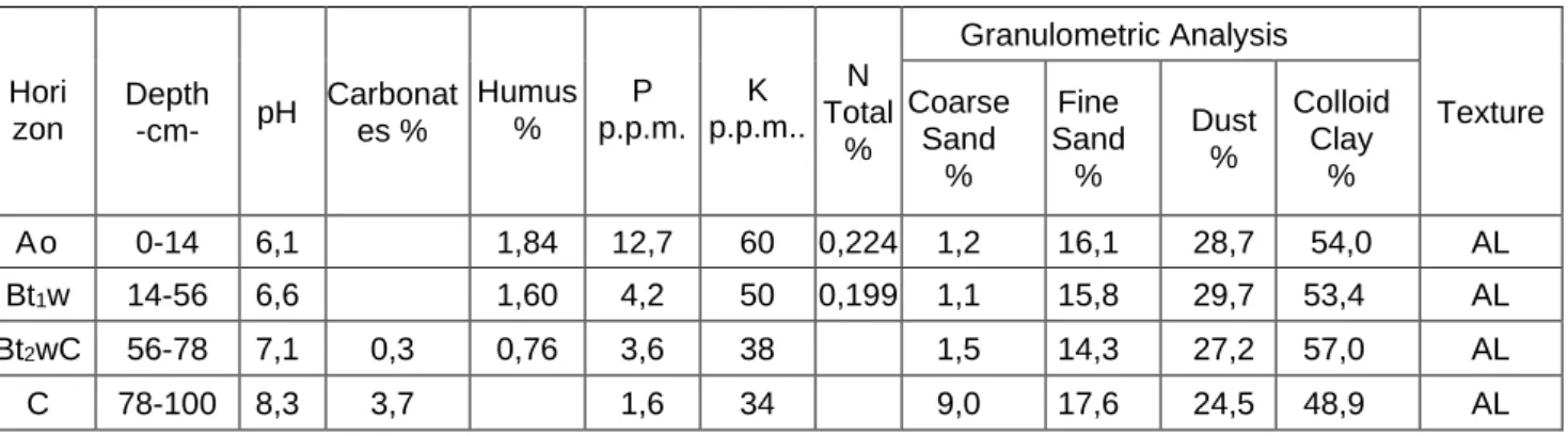
of weathered stagnic preluvisol (slope between 10 and 15%)
Hori zon
Depth
-cm- pH
Carbonat es %
Humus %
P p.p.m.
K p.p.m..
N Total
%
Granulometric Analysis
Texture Coarse
Sand %
Fine Sand
%
Dust %
Colloid Clay
%
Ao 0-14 6,1 1,84 12,7 60 0,224 1,2 16,1 28,7 54,0 AL
Bt1w 14-56 6,6 1,60 4,2 50 0,199 1,1 15,8 29,7 53,4 AL
Bt2wC 56-78 7,1 0,3 0,76 3,6 38 1,5 14,3 27,2 57,0 AL
C 78-100 8,3 3,7 1,6 34 9,0 17,6 24,5 48,9 AL
Bt2w horizon (between 49 and 74 cm), it is light brown with 30% rusty spots, 40% purplish, massive, clay-loam, finely porous, compact.
Bt3w horizon (between 74 and 100 cm), it is marbled with 40% rusty and 40% purplish spots, massive, clay-loam, finely porous, compact.
Bt2wC horizon (between 56 and 78 cm), it is marbled with rusty and purplish spots, large polyhedral edgy structure, AL texture, obvious effervescence, contains CaCO3 in the soil mass, it is finely porous,
compact environment.
C horizon (between 78 and 100 cm), it is yellowish with rusty spots,
massive, clay-loam texture, contains
CaCO3 in the form of agglomerations,
241
By comparing the profiles on the plateau with those on the slope, of the two soil units studied, the following aspects were highlighted:
- besides the thickness of the horizon from the surface to the slope soils showing the manifestation of the slow geological erosion, another morphological property, modified by this process, highlighted in the soils taken in the study, is the colour.
- at the two units on the plateau or in the upper third of the slope, the colour of the Ao horizon is dark (dark brown) due to the higher humus content, while on the slopes soils, with an inclination between 10 and 15%, the colour of the same horizon it is lighter (light brown), due to the gradual removal of the layer from the humidified surface.
In most cases, due to the erosion process, due to the decrease of humus content, there is a decrease of soil acidity, following the updating of better or totally saturated horizons in bases compared to the surface horizon of unweathered soils.
Erosion caused by water affects not only the morphological and chemical properties of the soil, but also the physical ones.
Thus, the partial loss of the A horizon of the slopes soils contributes to the increase of the apparent density on the profile, of the pH, of the withering coefficient, as well as the decrease of the total water capacity of the soil, of the field capacity, of the useful water reserves, soil porosity, etc.
The loss of soil each and every year from the horizons on the surface of the land, makes appear new modified physical and hydrophysical properties, which are inappropriate for plants life.
The action of surface erosion over time first affects the texture of the upper horizons, which from clay-loam (LA) in the Ao horizon to the stagnic preluvisol on the plateau with a slope between 2 and 5% evolved to a clay-loam (AL) texture in the Ao horizon to the weathered soil.
In the weathered stagnic luvisol, the clay (LL) texture on the Ao horizon evolved to a clay-sandy (LN) texture on the El horizon.
The soil structure also suffer changes which, under the action of the falling rain drops, strike the structured soil aggregates, located on the surface of the land, throwing the pulled material at variable distances from the place of impact, thus favouring weathering and reducing the water stability of soil
aggregates, therefore, of the soil
structure.
The immediate effects of this destructive action are the decrease of the aeration degree of soil and increase of apparent density.
On the depth of 20 - 50 cm the apparent density parameters change slightly.
The increase in the values of the apparent density means a significant reduction of the areas not covered by the weathered soils, depriving them of the possibility of accumulating as much water as possible, to be made available to the plants.
The worsening of soil weathering relationships with water as the main circulating means of transport of nutrients (which are already insufficient on slopes) in the vital soil-plant circuit, is one of the most important factors of the productions that can be obtained in all crops on slopes.
186
nitrogen content also decreased by 0.087, the mobile phosphorus content decreased by 5 ppm, and the mobile potassium content also decreased by 18 ppm.
CONCLUSIONS
The surface weathering is
manifested by the gradual and almost uniform removal on the entire surface of the slope of fertile layers. Dislocated soil or rock particles are the result of the
associated action of raindrops or
dispersed water leakage.
Surface weathering affects not only the morphological and chemical properties of the soil, but also the physical ones. Thus, the partial loss of the A horizon of the slopes soils contributes to the increase of the apparent density on the profile, of the pH, of the withering coefficient, as well as the decrease of the total water capacity of the soil, of the field capacity, of the useful water reserves, soil porosity, etc.
Knowing the consequences of surface weathering, for the protection of soils, human activity is very important, as regards the systematization of crops on arable lands, the choice of land use category, the use of the technological system of plant cultivation, exploitation of forest resources, rational grazing and a sustainable development management in the Gorj County.
It is recommended to identify the areas at risk of weathering as accurately as possible, in order to intervene through consolidation, stabilization, levelling, land modelling and other hydro-ameliorative measures.
It is recommended the best choice of the use category, lands estimation, use of the appropriate agro-technical system,
in order to prevent the negative
weathering effects, in order to preserve the main means of production.
BIBLIOGRAPHY
1. Bălan M., 2010. - Starea de calitate a unor soluri erodate din Judeţul Gorj. Teză de doctorat, Facultatea de Agricultura a Universităţii din Craiova.
2. Bălan M., Craioveanu Ghe., Carigoiu
V., 2011 - Aspecte privind eroziunea
solurilor din Judeţul Gorj. Editura Universitaria Craiova.
3. Fliche E., Purnavel Ghe., Popa N.,
2000 - Influenţa pierderilor de elemente
fertilizante de pe terenurile agricole asupra calităţii apelor de suprafaţă.
Analele Univ. Ovidius, Constanţa.
4. Popescu Cristian, 2015 - Physical and chemical characterization of main soils from north part of Dolj district,
Analele Universitatii din Craiova,
Agricultura, Montanologie, Cadastru, vol. XLV /1 , pag 227-231 ,ISSN 1841-8317. 5. Popescu Cristian, 2017 - The suitability classes as arable land of soils
from South – Western zone of Dolj
District, the territory of Piscu Vechi and Ghidici localities, Analele Universitatii din
Craiova, Agricultura, Montanologie,
Cadastru, vol. XLVII /1 , pag 374-378, ISSN 1841-8317, ISBN CD-ROM 2066-950X
7. Popescu C., 2016 - The modification of some features of soils located nearby chemical plant Craiova zone that is affected by noxioux substances. SGEM
2016 Conference Proceedings, 3/