RÖMISCH-GERMANISCHE KOMMISSION, FRANKFURT A. M.
EURASIEN-ABTEILUNG, BERLIN
des Deutschen Archäologischen Instituts
Kolloquien zur Vor- und Frühgeschichte
Band 10
INTERDISCIPLINARY CENTRE FOR THE STUDY OF THE ANCIENT WORLD
FREE UNIVERSITY OF BERLIN
Friederike Fless
COLLECTION OF CLASSICAL ANTIQUITIES
NATIONAL MUSEUMS IN BERLIN
Andreas Scholl
COMPUTER APPLICATIONS AND QUANTITATIVE METHODS IN ARCHAEOLOGY
GERMAN CHAPTER
Irmela Herzog, Tim Kerig, Axel Posluschny
Layers of Perception
Proceedings of the 35
thInternational Conference on Computer
Applications and Quantitative Methods in Archaeology (CAA)
Berlin, Germany, April 2-6, 2007
Edited by
Axel Posluschny, Karsten Lambers, Irmela Herzog
Layers of Perception – CAA 2007 322
Hanna Stöger
Roman Ostia: Space Syntax and the Domestication of Space
Abstract: Ostia, Rome’s harbour city, offers one of the few archaeological sites where the full complexity of Roman urban life can be investigated. Despite wide-ranging scholarly interest in Ostia’s built environment, the city’s spatial organisation has not previously received much attention. This study focuses on one of
Ostia’s city-blocks, Insula IV ii, analysing the insula’s spatial configuration, its inner communication via the courtyards, as well as the insula’s integration and interaction with the exterior, the city’s street network. By
applying Space Syntax’s analytical tools (UCL Depthmap software for spatial analysis) this paper highlights some of the spatial and visual patterns possibly experienced by its inhabitants and visitors.
Introduction
Since Ostia’s insulae of the 2nd century AD came to
light during the large-scale excavations of the late 1930s, they have been attracting widespread re-search interest, ranging from structural assessments1 to attempts to claim that ideological continuity between Roman imperial and Italian fascist archi-tecture2. Current approaches view particular insu-lae as short-lived material manifestations of
archi-tectural dreams, quickly responding to changing
demographic and economic demands3, while others emphasis their infra-structural capacity and ability to adapt to dynamic urban processes.4 Whereas ear-lier studies on insulae concentrated on typological and cultural-historical explanations5, more recent approaches follow advances made in Pompeian studies, partially integrating concepts of today’s urban planning and urban geography into archae-ological research.6 With reference to Ostia, these studies incorporate aspects of the insulae’s spatial organisation into research deploying a wider social focus relating to status and ownership7.
Space Syntax’s methods of spatial analysis add a new perspective to the current insula discussion.
Space Syntax techniques not only give evidence for
the intricate organisation of space within the in-sula, but also investigate the active role of spatial characteristics, considering the ways in which built spaces themselves function to pattern the social
in-teraction taking place within them8. Ostia’s insula IV ii serves as a case study, while various other
insulae equally warrant a detailed spatial analysis.
Still, insula IV ii is of particular interest. Firstly, as yet it has not received much scholarly attention and thus remained largely unpublished9. Secondly, a
number of spatial features, consisting of interlinked
courtyards, render insula IV ii are a very appeal-ing dataset for spatial analysis. This paper presents
the first results applying selected Space Syntax
analysis tools10. For better clarity it also includes archaeological information and places the spatial discussion within the context of Ostia’s 2nd century
AD urban development, widely understood as a “boom-town” phenomenon11.
1bauers 1999, 26.
2 See kockeL 2001, 66–72 on G. Calza’s influence on architectural interpretation. 3GerinG 2002.
4scaLiarini-corLàita 1995; steuernaGeL 2001. 5Packer 1971; Pasini 1978.
6Laurence 1994; FrideLL anter / weiLGuni 2003. 7deLaine 1999; 2004; GerinG 1999.
8 Cf. anderson 2005.
9rieGer (2004) briefly discusses selected buildings of the insula in relation to the adjacent Campo della Magna Mater. 10 Depthmap (UCL version) 6.0824r.
Insula IV ii – Location and Description
Insula IV ii, is located on the southern cardo max-imus, one of Ostia’s principle streets which leads from the forum towards the gate to Laurentum, which connects to the rural areas southeast of Os-tia. Placed at the intersection between the cardo and the Via della Caupona, (a side road south off the cardo), the insula appears well positioned
within the urban street network (Fig. 1). Towards the East, the triangular area of the Campo della Magna Mater, one of Ostia’s main sanctuaries, de-limits the insula. Its eastern and southern extent are limited by borders of retaining walls of height of
about 1.50–2.00 m, which keep in place a fill layer
presumably placed when the terrain was levelled prior to development during the Trajanic period (98–117 AD).
The insula covers a total area of 7420.60 m2
com-prising 14 buildings. The visible architectural re-mains largely date to the second half of the second century AD, with earlier structures (Trajanic period) still extant in the southern part along the retaining wall. In the northern part of the insula, along the car-do, the Caseggiato dell’Ercole (2nd half of the second
century AD), a multi-storey apartment block with commercial space at ground floor level replaced
the earlier, possibly Late Republican/Early Augus-tan buildings12. The bath-complex of the so-called Terme del Faro lies along the eastern boundary wall
next to the Campo della Magna Mater. Starting from the street front along the cardo, the baths continue almost the entire length of the insula. Their building history cannot be fully reconstructed. The existing baths have been installed during the Severan period (end of the 2nd century AD), replacing preceding
structures of unclear date and function13. From the standing remains it can be assumed that all build-ings still standing were in use during the end of the second century AD, forming a simultaneously exist-ing spatial relation.
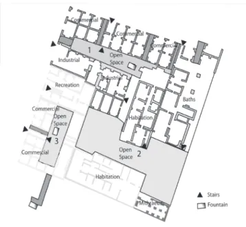
The insula is characterised by diverse land-uses, representing a built environment that potentially accommodated commercial, recreational, sacred,
communal and habitation space within its confines. These spaces were not only linked functionally, but
also through a structural relationship provided by
spatial interdependence within a configuration of
spaces (Fig. 2). A number of the insula’s spatial char-acteristics are readily apparent. Commercial space was predominantly located along the street fronts, maximising the potential for accidental visitors at the building’s interface with public space. Industri-al space, on the other hand seemed to reach deeper into the insula, within the narrow end of the plot along the street front. The southernmost corner of the insula, the area least accessible, was dedicated to a mithraeum, a cult room serving a limited number of members devoted to Mithras. Several buildings
Fig. 1. Ostia’s built environment within the excavated areas. The circle marks insula IV ii.
Layers of Perception – CAA 2007 324
provided dwelling units at ground floor level, while
the majority of habitation space was located on the
upstairs floors. Five staircases are linked directly to
the public domain of the street-space; they offer ac-cess to the upstairs areas independent of the inner space of the insula. Five additional staircases are
present in buildings inside the insula, linking those
upstairs areas closer to the insula’s internal commu-nication (Fig. 2). The insula’s communication with
Ostia’s public space, the street network, appears similar to today’s gated communities, defined as a
residential social system that closes itself off from other areas through some social or physical mecha-nism14. Every individual entrance to the street could be closed off; travertine thresholds are still present in situ. In addition, the portico along the cardo max-imus could be barred off, adding a further screen building between the insula and the public domain. The insula could close itself off from the street
net-work, and could still keep internal movement flow.
Spatial Assessment and Space Syntax
Descriptive qualitative methods of analysis often seem beneficial, even more so when spatial charac -teristics give the impression of being evident and
ob-vious. However, description sometimes substitutes
for understanding the spatial laws of interaction and visibility and fails to comprehend generative spaces for social activities15. By exploring different ways of formal spatial assessment, a better understanding of the insula’s spatial organisation and its social activi-ties can be achieved. The emphasis needs to be on
the term ‘exploring’. Hillier and Hanson state that it
is impossible to establish in advance which spatial
dimensions are likely to be the most relevant16, thus
it becomes the researcher’s task to discover which
representation and which measure captures the logic of a particular system17.
Physical Form and Size of Space
To begin with, the most straightforward approach to space is the physical size and the form of spaces.
This is already quite informative. Plotting out the
insula’s covered and open spaces leads to a ration of 4:1, with 25% of the total area left open (Fig. 2). This accounts for a larger area than that which was dedi-cated to commercial space, which covers about 20%. At the same time the insula dedicates some 20% to recreational space18. Habitation space is difficult to
assess since it was mostly located on upper floors no
longer extant. Nevertheless from the generous dis-tribution of open spaces and the diversity of
land-use some assumptions relating to the quality of the
“lifeworld” within the insula can be made. Urban theory postulates that next to a lively mix of
land-use and building types, particular qualities of the
physical city are also needed to provide for a good neighbourhood.19 These physical qualities include
doors directly entering the streets, small walkable blocks and the opportunity for pedestrians to turn corners frequently; all of these features are present
within insula IV ii.
Space Syntax Analysis Tools
For economy of purpose only the basic
princi-ples of Space Syntax will be briefly introduced:
14 see bert Lott 2004, 18–19 on neighbourhoods in modern thought. 15cLark 2007, 85.
16hiLLier / hanson 1984. 17 Cf. thaLer 2005.
18 Total area of insula IV, ii 7240.60 m2, the open space covers 1851 m2.
19 Cf. jacobs 1961.
general trends and problems in the archaeological application of Space Syntax methodology have been discussed elsewhere20. Space Syntax is built on two
formal ideas, which try to reflect both the objectivity
of space and our intuitive engagement with it. First, space is an intrinsic aspect of all activities that hu-man beings do. Secondly, huhu-man space is not about the properties of individual space, but about the
in-terrelations between the many spaces that make up the spatial layout of a building or a city, the configu -ration of space21. Thus all human activities have a necessary spatial geometry: movement is linear,
in-teraction requires a convex space in which all points
can see all others, and from any point in space we
see a variably shaped visual field, called isovist22.
A promising starting point for most spatial analysis
is access analysis, which allows quantitative assess -ment of integration and segregation within a closed spatial system. Access analysis is calculated by means of the topological distances between a given space and all other spaces in the system, thus it can indicate how central a given space is within the total
move-ment flow within the insula. A strictly quantitative assessment would require a calculation of numerical indicators for all spaces. A qualitative description of the so-called j-graph (justified graph) already allows
a deeper understanding of the insula’s spatial organi-sation. With regard to insula IV ii, it is immediately
noticeable that the primary areas of access were pro-vided by the long entrance corridors leading into the insula, while all commercial spaces along the street
fronts were directly linked to the public carrier space. In all, 39 spaces connect to the outside space, making
the insula highly permeable towards the city’s street
network. In contrast, none of the spaces located along the retaining walls are linked to the outside. Inside
the insula, the courtyards come into action and act as major integrators and distributors mixing movement
into and within the insula. The first courtyard con -trols 17 spaces and is located behind the large
multi-story apartment block (Cassegiato dell’Ercole) with ground-floor tabernae (shops and pubs). The court -yard is between 1 and 3 topological steps (depth-steps) away from the outside and only 1 depth-step from the second courtyard located deeper inside the insula. The second courtyard controls 11 spaces and offers the largest open space. It is the only courtyard directly connected to all other courts via passage corridors. The third courtyard is located within a commercial building along the Via della Caupona and controls fourteen spaces. The presence of three courtyards could potentially engender a sense of fragmentation within the insula, however this seems balanced by the fact that the largest courtyard acted as a centre for the entire layout. This becomes clearly visible through Depthmap analysis and the visibility graphs produced by Depthmap.
20thaLer 2005, 324-326. 21hiLLier / vauGhan 2007.
22hiLLier / vauGhan 2007; cf. turneretaL. 2001.
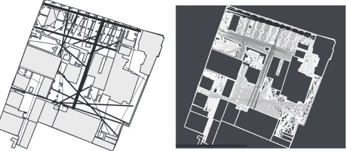
Fig. 3. (left) Axial connectivity graph, ranking of integration is indicated by thickness of lines; (right) Visual axial line
Layers of Perception – CAA 2007 326
Depthmap for Spatial Analysis
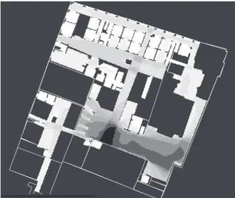
Depthmap software for spatial analysis offers user-friendly Space Syntax tools compatible with maps created in MapInfo or AutoCAD. Out of a larger number of analysis tools, axial line analysis and vis-ibility analysis have been chosen to closer investi-gate insula IV ii. The graphs produced are based on the longest visual lines and their visual integration. To some extent they are visual aids to better under-stand the spatial dynamics. Very often the structural properties of space are complemented by visual properties23. The graph shows those spaces which are visually most integrated or segregated, through
colour coding reaching from red to blue. The black and white rendering shows the darker areas as
those visually integrated through to the lightest for the least integration(Fig. 3, Fig. 4).
Depthmap line analysis, calculated for axial con-nectivity based on the longest visual lines,
identi-fied the visual line reaching from the portico to the
second courtyard as the most integrated line, fol-lowed by the visual line along the street-front of the
portico. The line ranking third runs along the first
courtyard. Clearly the courtyards are converging
points for visual lines from all directions, making
the courtyards the prime spaces for social encounter
(Fig. 4). Interestingly enough, the fountains located within the courtyard were placed in a way so as not to obstruct long visual lines.
Conclusion
The spatial case study of Ostia’s insula IV ii has demonstrated that syntactical and visual tools of spatial analysis can add an interesting dimension to the archaeological assessment of a past built en-vironment. Spatial aspects can be detected which would otherwise not be noted by observation only. The real advantage of Space Syntax lies in the fact that the method forces the researcher to understand
a building or a group of buildings as a configuration of space. With regard to the insula and its quality as lived space, spatial tools could make a valuable con -tribution to show that within the insula space was designed to promote encounters, and to promote
in-tegration over segregation, which ultimately makes
for a better and safer neighbourhood, not only in 2nd
century Ostia.
References
anderson 2005
M. anderson, Houses, GIS and the Micro-Topology of
Pompeian Domestic Space. In: TRAC 2004. Proceedings of the Fourteenth Annual Theoretical Roman Archaeol-ogy Conference (Durham 2004) 144–156.
bauers 1999
n. bauers, Insulae dell’Ercole Bambino und del Soffitto
Dipinto (II vi 3–6): Untersuchungen 1997–1998. Meded 58, 1999, 26.
bert Lott 2004
j. bert Lott, The Neighbourhoods of Augustan Rome
(Cambridge 2004).
caLza 1953
G. caLza, Scavi di Ostia I (Roma 1953).
cLark 2007
d. cLark, Viewing the Liturgy: a Space Syntax Study
of Changing Visibility and Accessibility in the Develop-ment of the Byzantine Church in Jordan. World Archae-ology 39:1, 2007, 84–104.
deLaine 1999
j. deLaine, High Status Insula Apartments in Early Im
-perial Ostia – a Reading. Meded 58, 1999, 175–189.
deLaine 2004
j. deLaine, Designing for a Market: Medianum Apart
-ments at Ostia. Journal of Roman Archaeology 17, 2004, 146–176.
23hiLLier / vauGhan 2007, cf. anderson 2005, 152–153.
FrideLL anter / weiLGuni 2003
k. FrideLL anter / M. weiLGuni, Public Space in Roman
Pompeii. In: G. MaLM (ed.), Towards an Archaeology of
Buildings: Contexts and Concepts. BAR International Series 1186 (Oxford 2003) 31–39.
GerinG 1999
a. GerinG, Medianum-Apartments: Konzepte von
Wohnen in der insula im 2. Jh. n. Chr. Meded 58, 1999, 102–115.
GerinG 2002
a. GerinG, Die Case a Giardino als unerfüllter
Ar-chitektentraum. Planung und gewandelte Nutzung einer Luxuswohnanlage im antiken Ostia. Mitteilungen
des Deutschen Archäologischen Instituts, Römische Abteilung 109, 2002, 109–140.
heinzeLMann 2002
M. heinzeLMann, Bauboom und urbanistische Defizite
– zur städtebaulichen Entwicklung Ostias im 2. Jh. In:
c. bruun/ a. GaLina zevi (eds.), Ostia e Portus nelle loro
relazioni con Roma. Acta Instituti Romani Finlandiae 27 (Roma 2002) 103–122.
heinzeLMann 2005
M. heinzeLMann, Die vermietete Stadt: Zur Kom
-merzialisierung und Standardisierung der Wohnkul
-tur in der kaiserzeitlichen Grosstadtgesellschaft. In:
r. neudecker/P. zanker (eds.), Lebenswelten: Bilder
und Räume in der römischen Kaiserzeit. Palilia 16
(Wiesbaden 2005) 113–128.
hiLLier / hanson 1984
b. hiLLier / j. hanson, The Social Logic of Space
(Cambridge 1984).
hiLLier / vauGhan 2007
b. hiLLier / L. vauGhan, The City as One Thing. Progress
in Planning 67:3, 2007, 205–230.
jakobs 1961
j. jakobs, The Death and Life of Great American Cities
(New York 1961).
kockeL 2001
v. kockeL, ‘Il palazzo per tutti’. La découverte des
im-meubles locatifs de l’Antiquité et son influence sur
l’architecture de la Rome fasciste. In: j.-P. descoeudres
(ed.), Ostia port et porte de la Rome antique (Genève
2001) 66–73.
Laurence 1994
r. Laurence, Roman Pompeii: Space and Society
(London 1994).
MeiGGs 1973
r. MeiGGs, Roman Ostia (Oxford 1973).
Packer 1971
j. Packer, The Insulae of Imperial Ostia. Memoirs of the
American Academy in Rome 31 (Rome 1971).
Pasini 1978
F. Pasini, Ostia Antica. Insule e classi sociali (Roma
1978).
PavoLini 2006
c. PavoLini, Ostia (Roma, Bari 2006).
ricciardi / scrinari 1996
M. ricciardi / v. scrinari, La Civilta dell’Acqua in Ostia
Antica (Roma 1996).
rieGer 2004
a. rieGer, Heiligtümer in Ostia. Studien zur antiken
Stadt 8 (München 2004).
scaGLiarini corLàiti 1995
d. scaGLiarini corLàiti, Le grandi insulae di Ostia come
integrazione tra edilizia residenziale e infrastrutture urbane. In: G. cavaLieri Manasse / e. roFFia (eds.),
Splen-dida civitas nostra. Studi archeologici in onore di A. Frova (Roma 1995) 171–181.
steuernaGeL 2001
d. steuernaGeL, Kult und Community. Über Sacella in
den insulae von Ostia. Mitteilungen des Deutschen Archäologischen Instituts, Römische Abteilung 108, 2001, 41–56.
thaLer 2005
u. thaLer, Narrative and Syntax: new perspectives on
the Late Bronze Age palace of Pylos, Greece. In: a. van
nes (ed.), 5th International Space Syntax Symposium
Proceedings Vol. II (Delft 2005) 323–339.
turneretaL. 2001
a. turner / M. doxa / d. o’suLLivan / a. Penn, From
is-ovists to Visibility Graphs: a Methodology for the Anal-ysis of Architectural Space. Environment and Planning B: Planning and Design 28:1, 2001, 103–121.
Hanna Stöger Faculty of Archaeology University of Leiden
Reuvensplaats 3