An Energy Efficient Data Collection Using Multiple
UAVs in Wireless Sensor Network: A Survey Study
Alaa Taima Albu Saliha Sayeed Amen Hosseini Senob
a,bFerdoowsi University of Mashad, Iran
[email protected] [email protected]
Submission date:- 22/5/2018 Acceptance date:- 24/6/2018 Publication date:- 23/9/2018
Keywords: Data Collection, WSN, UAV, Energy effciency, Deadline, Optimal Trajectory.
Abstract
Today, with scientific and technological advances in robotics, artificial intelligence, control and computers, land, air and sea vehicles, they have been considered. Unmanned aerial vehicles (UAVs) have also significantly improved and are very useful for many important applications in the business, urban and military environment. One of the important uses of UAVs in Wireless Sensor Networks (WSNs) is that devices with low energy and may not be able to communicate in large areas. Nevertheless, a UAV can provide a tool for collecting the data of WSN from one device and transmitting it to another device. This article focuses on the field of research on practical applications of UAVs as mobile collectors for wireless sensor networks. First, the investigations of the proposed UAV were studied and compared their weaknesses with each other. Then, the technical challenges of the applications of UAVs in the wireless sensor network were explored.
1) Introduction
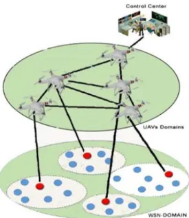
In the near future, millions UAVs, also known as drone, are expected to quickly operate in different parts of our everyday lives and provide massive services [1]. In fact, drones can play a key role in Wireless Sensor Networks (WSNs), which consist of devices with a limited battery size, like health monitors and sensors [2]. Because of their energy constraints, these devices can not normally be transmitted over long distances. In this WSN cases, UAV can dynamically move towards devices of WSN, gather data of WSN and transmit it to other devices which are out of the communication ranges of the transmitters.See Figure 1.
The main applications of communications supported by the UAV can be divided into three categories [3]: 1) Coverage everywhere with the UAV, in which UAVs are used to provide integrated telecommunication coverage in the targeted area to assist existing ground telecommunication infrastructures. In this case, UAVs act as aeriel base stations (BS) [4]. The UAV-based wireless communications have their unique ability to connect quickly, reliably and cost-effectively to areas covered by poorly-grounded networks [5].
2) One of other promising applications is UAV aided relaying where UAVs are sent for providing reliable wireless connection between two or more distant users or group of users in enemy environment, like communication between front and base for emergency answers or army operations [6],[7].
3) UAV systems can also be used to collect data / disseminate information using UAV. This is attractive especially for periodic application or wireless sensor networks (WSNs) in which UAVs can fly through sensors for communications, greatly reducing the operational capacity of the sensors, thereby increasing the lifespan Increase the network [8-9].
Data collection with UAVs not only has the elasticity of a mobile data set appropriate for a WSN large scale network, but also has the following benefits [10]:
1. The deployment environment is different. Aerial data collection using the UAV can be automatically guided as a moving data collector. There is no mobility constraint on land transport and can be used in specially monitored areas that humans can not access.
2. Aerial collectors of data sets collect information much faster. Compared with the collection of terrestrial data sets, aerial data collection can be controlled using an UAV that has faster movement. This can increase the search speed and visit nodes, and reduce the lifecycle of WSN data when network has a large scale sensor network. 3. The delay is lower and the bandwidth is higher. Compared to air to ground data gathering, aerial data sets have less obstacles and bigger wireless signal coverage, which can reduce communication delays and increase bandwidth.
Figure 1: The communication between UAVs and WSN devices
Drones play the significant role of mobile collector for WSN networks. Nevertheless, for the effective use of UAVs for WSN communications, there are several challenges such as optimal positioing, optimal trajectory, data routing, user participation, air-to-ground modeling, and the efficient use of energy for UAVs and WSN nodes must be considered. The main goal of this article is to provide outline on these callenges of UAVs as mobile collectors for WSN.
The reminder of this article is as follow: in section 2, related works on using UAV in wireless sensor networks are examined. Lastly, conclusion and future works are presented in third section.
2) Efficient Data Gathering in WSN Using Multiple UAV:Challenges
In spite of several practical advantages and applications of UAVs as air base stations, many practical challenges such as optimal trajectory, optimal positioning, data routing, air-2-ground modeling, user participation, hovering time optimization and use of energy efficient UAVs and WSNs. Related articles in this area can be classified according to the previous challenges, which we will examine in each of these categories.
2.1 Optimal Trajectory:
One of the most significant challenges in UAV aided communications is the optimal route. Feng et al. [11] have presented a multi criteria optimization model for UAV ttajectory to monitor the road sector, aimed at minimizing the UAV distance and minimizing the no. of used UAVs. An evolutionary algorithm based on the Pareto optimization method for solving a multi-objective UAV path planning problem. The issue of scheduling UAV routing was a single-objective optimization problem, without considering the difference between road sections and road nodes. In fact, the length of the road segment, the no. of UAVs available, the maximum spacing of UAV, and multi-objective optimization can be influenced jointly by the UAV route planning results, but this is rarely taken into consideration. Therefore, in this paper, the above considerations are considered, a multi-purpose UAV path planning model is constructed, and then an evolutionary algorithm is proposed for solving a multi-objective routing programming problem for the UAV.
Zeng et al. [12] study the point-2-point link between the ground user and an UAV with the aim of improving the trajectory of UAV. A new strategy model that takes into accounts the UAV's power and communications capability together. To this end, the theoretical model for the propulsion of UAVs was fixed as a purpose of the flight velocity, direction, and acceleration of the UAV. Based on the proposed model and by disregarding the energy consumption of the signal processing, the efficiency of the energy of the UAV communications is defined. In case of unconstrained trajectory optimization mode, they show that both maximizing and minimizing energy leads to a reduction in energy efficiency, resulting in overall inefficient energy. Next, they present a UAV trajectory, below which the flight range and UAV velocity are improved to maximize the efficiency of UAV energy. Additionally, an efficient method is suggested maximize the efficiency of UAV energy with overall directions for the trajectory, including its start and end locations, and its speed, in addition to maximum/minimum velocity. As a result, the proposed projects will significantly increase the UAV energy efficiency. This article is intended for single UAVs and does not consider multiple UAVs.
2.2 Optimal Deployment:
One important design aspect of UAVs is UAV deployment. For multiple UAV-aided WSN communications in particular, appropriate UAV deployment may significantly shorten the communication distance and thus is crucial for high-capacity performance. Unfortunately, finding the optimal deployment for UAV is a challenging task in general, Yakici in [13], studied the problem of positioning and roting of UAVs at a planned level with a target function. They traverse the problem as an ILP (Integer Linear Program) with the goal of maximizing the overall score gathered from points of interest, visited by aircraft trajectories. These paths are set from designated stations that are assigned concurrently with the order of visiting points of interest for each path. They create an approach to an ant colony optimization (ACO) designed for the design of a compound problem. But in this article, only pre-allocated points are considered and do not use deadline.
Ladosz et al. [14] proposed a method to find the optimal location of UAVs as a relay node to improve the connectivity of network and the communication purpose of a team of vehicle/ground nodes. A complex 3-dimensional complex consisting of many constructions is measured to have often been blocked by the LOS between the nodes of the earth. The PSO (particle swarm optimization) method is applied to find the optimal UAV location using three criteria of performance of communication, based on the need. A simulation is done to demonstrate the advantage of using UAVs as relay and specific criteria in typical scenarios. A stationary, internal concept test is also being executed to illustrate the possibility of the proposed method in real time. This article did not take into account the deadline time in their analysis.
2.3 Data Routing:
Routing is the only issue that remains active on all types of networks. For multi-UAV networks, robust and error-tolerant routing protocols are required that can provide a minimum delay during route selection, efficient path reconnection, fast recovery, improved control over delays and jitter. Yu et al. [15], an ant colony optimization based polymorphism based routing strategies is suggested for the APAR strategy to solve problems. This strategy combines the ACO strategy and the DSR routing strategy, the level of pheromone in the paths found in the routing discovery process, is selected as the standard for selecting the route, and by route distance calculation, the loading level of a route, and Track steadiness. A fresh pheromone evaporation algorithm is also presented into the strategy. Meanwhile, the strategy can change the formation of the air force to avoid compromise the performance of network. The results of simulation show that the APAR strategy is based on traditional strategies in PDR, end-2- end ending, overhead, and reliability in the battlefield surveillance.
Rosati et al. [16] compared the performance of POLSR and OLSR in FANET consisting of fixed drones. Like networks are described by a high degree of mobility that challenges the routing protocol. protocols designed for MANETs have often failed in tracing the network topologies evolution. They solve this problem by creating the extension of OLSR called POLSR: the use of GPS data to forecast the quality of wireless links evolves. Simulation of networks and field experiments confirms our expectations. With POLSR, routing is looking for uninterrupted topology changes, which is not the case with OLSR.
3.4 Efficient Data Gathering.
Another major challenge in UAV-based communications is the effective data collection method. Wang et al. [10] have developed a novel framework for aerial data gathering, which have the following five components: networks deployment, node positions, endpoint searches, rapid route planning for the UAV and Collect data from the network. They identify important challenges in each of componets and propose effective solutions. This involves proposing a FPPWR (Fast Launch Route with Rule) algorithm based on the network segment, increasing the route planning efficiency, while ensuring the path length is relatively short. This UAV article did not consider the deadline time and the optimal number of UAVs in their analysis.
Ho et al., in [17], has chosen the WSN connection and the use of UAVs for data gathering. Typical wireless sensor networks (LEACHs) are usually used to select clusters for energy conservation purposes. Energy saving is very difficult to deploy on a large scale. PSO (Particle swarm optimization) has been suggested as an optimization method to find an best topology for reducing the consumption of energy, travel time of UAV, and BER (bit error rate). The PSO is compared using a LEACH simulation file and the simulation results show that the PSO of LEACH is bigger to BER and energy consumption, while the travel time of UAV is the same. Further results indicate that the gap of performance between them increases when no.of cluster head nodes increaased. Because of energy consumption reduction, network lifetime can be significantly increased while the amount of data received increasing from the entire network. Considering the effect of wind in the PSO design, it has been displayed that this effect affects the time of travel for the UAV, but energy consumption and BER do not meaningfully increase. Data collection has not been carried out with a multiple UAVs and did not take deadline time.
2.5 Energy Efficient of UAV and WSN
Another major challenge in UAV-based communications, saving energy from UAVs and WSN. Zorbas et al. [18] addressed the issue of efficiency of energy of the drone in the tracking of target states by setting no. of active drills. Where drone aided cameras are capable of detecting and tracking moving events that occur on the earth. A mathematical formulation has been devoted to minimize the overall energy consumption of UAV, which covers all events. Because of the very complexity of the optimization problem, the optimuim solution for even small
specimens can not be achieved. In contrast, LAS is a local solution to the problem, given the ability of drones to fly at low altitudes to maintain energy. In this article, the authors assumed that the position of the targets was already identified and the randomness of the network was not taken.
Li et al. [19] proposed an effective energy saving relay scheme that could extend the life span of cooperative UAVs in unfriendly environments. A difficult NP-hardness optimization problem is designed to ensure the success of packaging and energy balance. A useful sub-optimal solution was created by separating energy balance and speed adaptability, and doing these two parts alternately. The results of simulation indicate that our sub-optimal method can decrease computational complexity with different values, with a significant reduction in performance and network lifespane compared to optimal solutions. The sub-optimal method can also preserve energy by 50%, increase network performance by 15%, and increase network life expectancy by 33%, compared to current algorithms. The above article did not consider the UAV's optimal deployment, the deadline, and the optimal number of UAVs in their analysis.
2.6 Air to Ground Modeling:
In the following articles, writers conducted air-2-ground modeling for UAV-aided communications. Jeong et al. [20] studied a UAV-aided MCC system in which a UAV moving with computational abilities has been limited to providing computational offloading process to mobile users with local processing abilities. This system aims to minimize total energy consumption. Offloading is activated by using downlink and uplink communications between mobile usres and UAVs. The problem of optimizing bit allocation for downlink and uplink communications, also solved for successive convex approximation strategies (SCA), has also been solved for calculating the UAV along with the super-small path line under the UAV energy budget constraints and the latency. The advantage of this method is the important energy savings that can be enhanced by the common optimization provided by the binary allocation and the super-small path, compared with the implementation of local animations, in addition to optimization approaches that only designate super-short path mapping. This was limited to a UAV and did not consider the deadline time and optimal number of UAVs in their analysis.
Hourani et al. [24] suggest a statistical diffusion model to predict the loss of the air-2-ground route between a low altitude platform and a ground device. The forecast is based on the characteristics of the urban environment and depends on the elevation angle between the device and the platform. The model displays that the loss of the air route to the ground, there are two main propagation sets identified with two different profiles of the tarajectory. They provided a generic AM-RF radio release model for low-end operating systems that could significantly simplify the efforts planning of air wireless services, because RF could be done based on simple urban parameters - Models that are unlikely to be simply accessible and up to date. The loss of the air-to-ground route had a full tendency toward two separate release groups, which were fully illustrated for outdoor recipients.
2.7 User (Device) Association.
Another major challenge in UAV-based communications is UAV and WSN devices association. The work in [9] has studied how to use the UAV to improve connectivity to the MANET network. They presneted four types of connection: k connection, network connection, worst case, and global message. They formulated positioning and movement issues for drone and designed adaptation algorithms to provide a good performance in addition to simple solution. They provided a analysis for a simple case of a dual UAV and showed that an increase in the UAV provides a 240% upgrading in connectivity of global message. For general network settings, a UAV can improve the connectivity of global message and worst case connectivity by 109% and 60%. They showed that the network connection and k connection were also enhanced by adding a drone to the network. The data collection has not taken place with the UAV, and they did not take deadline time.
In [21], a new framework for connecting optimally optimized cells to cellular networks with the UAV is presented. Specifically, in order to minimize the interference of the average network in any arbitrary space distribution from users, optimal partitions of the cells and ground stations (BSs) are determined. To this end, using the powerful mathematical transport theory, the solution to the problem of cellular connectivity is proven, and the solution space is fully characterized. The analytical and simulation results indicate that the proposed approach will significantly improve the network latency on average.The proposed cell-line communication approach reduces network latency compared to a SNR-based communication.
2.8 Flight Time Optimization.
The drones' flight time offers a design challenge for UAV-based communication systems. Mozaffari et al. [22] is an effective use of UAV (unmanned aerial vehicle) flight as a flight BS that can examine wireless services to land users. Specifically, a new framework for optimizing system performance, including UAV based drone, is presented in terms of data services (average number of bits) conveyed to users in addition to UAV hovering. They considered two practical scenarios are. In the scenario1, based on the hovering rate, UAV may be the average of data services under a resource allocation plan that is fairly straightforward for users to maximize by finding the optimal companion patches associated with the UAV. In the scenario2, according to the load condition of the land users, the average hovering time in which the UAV is fully required to provide services to its land users. They did not consider the deadline and the optimal number of UAVs in their analysis
Henchey et al. in [23] allow the approximate flight time model to create a large set of estimated loads among the possible stations in a real time scenario. The model may be combined with operations for the UAV and the effects of wind on the UAV should bound their computing power, in spite of the obvious combination of increasing the average walking frequency. Then he presents the current art mode for approximate approaches. It shows arguments and methods for adding wind effects to approximate models. It describes these three variables for purposes including the effects of wind to the approximate the model of flight. Finally, providing a runtime analysis of the model comes with comparing real-time and approximate flight rates.
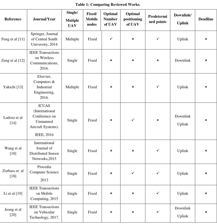
In Table 1, we compare the previous articles for the UAV-based WSN network based on deadline time parameters, optimal deployment, UAV optimal number, multiple UAVs, mobile nodes, and predefined locations. The table clearly shows that the existing approaches do not address the following issues:
Deadline timeout has not been reviewed.
The optimal deployment of UAVs was not investigated.
Do not check optimal number of UAVs.
Do not consider a multiple UAVs.
Do not consider mobile nodes.
Dependent on predefined locations.
Table 1: Comparing Reviewed Works.
Reference Journal/Year Single/ Mutiple UAV Fixed/ Mobile nodes Optimal Number of UAV Optimal positioning of UAV Predetermi ned points Downlink/ Uplink Deadline Feng et al [11] Springer, Journal of Central South University, 2014
Multiple Fixed Uplink
Zeng et al [12]
IEEE Transactions on Wireless Communications,
2016.
Single Fixed Downlink
Yakichi [13] Elsevier, Computers & Industrial Engineering, 2016.
Multiple Fixed Uplink
Ladosz et al [14] ICUAS (International Conference on Unmanned Aircraft Systems). IEEE, 2016 Single Fixed Downlink Uplink Wang et al [10] International Journal of Distributed Sensor Networks,2015
Single Fixed Uplink
Zorbass et. al [18]
Procedia Computer Science
2013
Single Fixed Uplink
Li et al [19]
IEEE Transactions on Mobile Computing, 2015
Single Fixed Uplink
Jeong et al [20] IEEE Transactions on Vehicular Technology, 2017. Single Fixed Downlink Uplink
Hen et al [9] IEEE TRANSACTION S ON VEHICULAR TECHNOLOGY, 2009
Single Mobile Downlink
Mozaffari et al [22]
IEEE Communications
Letters, 2017.
Multiple Mobile Downlink
Henchey [23]
John Wiley & Sons, Ltd, 2016 Single Fixed Downlink Uplink 3- Conclusions:
In this survey we attempt to focus on research in the areas of optimal trajectory, optimal positioning, data routing, air-to-ground modeling, user participation, hovering time optimization and use of energy efficient UAVs and WSNs. The reason to undertake this survey was lack of a survey focusing on these issues.
By identifying the key challenges of the UAV in the WSN network, accurate investigations of wireless communications using the UAV were carried out, which constitute the main features of this paper.
Three interesting directions are recommended for future research. Recommending distributed algorithm to achieve optimal route planning for UAVs based on clustering is the first direction. Second direction can suggest a framework for supporting mobile wireless sensor network. Last direction is extending suggested framework to support deadline based application.
CONFLICT OF INTERESTS There are no conflicts of interest. 4- References
[1] Z. Dawy, W. Saad, A. Ghosh, J. G. Andrews, and E. Yaacoub, “Towards massive machine type cellular communications,” IEEE Wireless Communications Magazine, to appear, 2016.
[2] M. Hassanalieragh, A. Page, T. Soyata, G. Sharma, M. Aktas, G. Mateos, B. Kantarci, and S. Andreescu, “Health monitoring and management using internet-of-things (IoT) sensing with cloud-based processing: Opportunities and challenges,” in Proc. International Conference on Services Computingn, New York, USA, June. 2015.
[3] Z. Yong, and Rui Zhang, and Teng Joon Lim ,"Wireless Communications with Unmanned Aerial Vehicles:
Opportunities and Challenges" IEEE Communications Magazine , Volume: 54 Issue: 5, 2016.
[4] M M Azari, F. Xavier Rosas, K. C. Chen, and Sofie Pollin. "Joint sum-rate and power gain analysis of an aerial
base station." Globecom Workshops (GC Wkshps), 2016 IEEE. IEEE, 2016.
[5] Kalantari, Elham, Halim Yanikomeroglu, and Abbas Yongacoglu. "On the number and 3D placement of drone
base stations in wireless cellular networks." Vehicular Technology Conference (VTC-Fall), 2016 IEEE 84th. IEEE,
2016.
[6], Y. Zeng, R. Zhang, and T. Joon Lim. "Joint Trajectory and Communication Design for Multi-UAV Enabled
Wireless Networks." IEEE Transactions on Communications 64.12 (2017): 4983-4996.
[7] K. Anazawa, Peng Li, T. Miyazaki, and S. Guo. "Trajectory and data planning for mobile relay to enable
efficient Internet access after disasters." Global Communications Conference (GLOBECOM), 2015 IEEE. IEEE,
2015.
[8] M. Mozaffari, W. Saad, M. Bennis, and M. Debbah. "Mobile Internet of Things: Can UAVs provide an
energy-efficient mobile architecture?." Global Communications Conference (GLOBECOM), 2016. IEEE, 2016.
[9] L. Zhu Han, A Swindlehurst, and K. J. Ray Liu, "Optimization of MANET Connectivity Via Smart
Deployment/Movement of Unmanned Air Vehicles", IEEE TRANSACTIONS ON VEHICULAR
TECHNOLOGY, VOL. 58, NO. 7, SEPTEMBER 2009.
[10] C. Wang , F. Ma, J. Yan, D. De, and S. K. Das."Efficient aerial data collection with uav in large-scale
[11] X. feng Liu, G. Zhi-wei, S. Yu-qing, and C. Da-shan. "An optimization model of UAV route planning for
road segment surveillance." Springer, Journal of Central South University 21.6 (2014): 2501-2510.
[12] Y. Zeng and R. Zhang. "Energy-efficient UAV communication with trajectory optimization", IEEE
Transactions on Wireless Communications 16.6 (2017): 3747-3760.
[13] E. Yakici, "Solving Location and Routing Problem for UAVs", Elesevier, Computers & Industrial
Engineering, Volume 102, December 2016, Pages 294-301.
[14] P. Ladosz, H. Oh, and W. Chen," Optimal positioning of communication relay unmanned aerial vehicles in
urban environments." , International Conference on Unmanned Aircraft Systems (ICUAS). IEEE, 2016.
[15] Y. Yunlong, L. Ru, W. Chi, Y. Liu, Q. Yu, and K. Fang, "Ant colony optimization based polymorphism-aware routing algorithm for ad hoc UAV network", Springer, Multimedia Tools and Applications November 2016, Volume 75, Issue 22, pp 14451–14476.
[16] S. Rosati, K. Krużelecki, G. Heitz, D. Floreano and B. Rimoldi, "Dynamic Routing for Flying Ad Hoc Networks", IEEE Transactions on Vehicular Technology (Volume: 65, Issue: 3, Page(s): 1690 - 1700, March 2016. [17] D. Ho, E. Ingar Grotli, P. B. Sujit, T. Arne Johansen and J. Borges Sousa,"Optimization of Wireless Sensor Network and UAV Data Acquisition", Springer, Journal of Intelligent & Robotic Systems April 2015, Volume 78, Issue 1, pp 159–179.
[18] D. Zorbas, T. Razafindralambo, and F. Guerriero. "Energy efficient mobile target tracking using flying
drones." Procedia Computer Science 19 (2013): 80-87.
[19] K. Li, W. Ni, X. Wang, R. Ping Liu, S. Kanhere, and S. Jha,"Energy-Efficient Cooperative Relaying for Unmanned Aerial Vehicles", IEEE Transactions on Mobile Computing 15(6):1-1 · January 2015.
[20] S. Jeong, O. Simeone, and J. Kang. "Mobile edge computing via a UAV-mounted cloudlet: Optimal bit
allocation and path planning." arXiv preprint arXiv:1609.05362 ,2016.
[21] M. Mozaffari, W. Saad, M. Bennis, and M. Debbah."Optimal Transport Theory for Cell Association in UAV-Enabled Cellular Networks", IEEE Communications Letters (Volume: PP, Issue: 99), 2017.
[22] M. Mozaffari, W. Saad, M. Bennis, and M. Debbah. “Wireless Communication using Unmanned Aerial Vehicles (UAVs): Optimal Transport Theory for Hover Time Optimization", IEEE Transactions on Wireless Communications, 2017.
[23] M. Henchey, J., Batta, R., Karwan, M., & Crassidis, A. ,"A Flight Time Approximation Model for Unmanned Aerial Vehicles.", In J. R. C. C. (Ret.), US Navy, & J. Q. D. Jr (Eds.), Operations Research for Unmanned Systems (pp. 95{117).John Wiley & Sons, Ltd, (2016).
[24] A. Hourani, S. Kandeepan, and A. Jamalipour, “Modeling air-to-ground path loss for low altitude platforms in urban environments,” in Proc. of IEEE Global Communications Conference (GLOBECOM), Austin, TX, USA, Dec. 2014. (UAVs) (WSNs) WSN . (WSNs) UAV