Free and Open Source GIS Software for
Building a Spatial Data Infrastructure
Stefan Steiniger, Andrew J. S. HunterDepartment of Geomatics Engineering, University of Calgary, 2500 University Drive NW, Calgary, AB T2N 1N4, Canada, email: [email protected]
Abstract The implementation of Spatial Data Infrastructures (SDIs) for govern-ments and companies is a task that has gained ample attention in recent years. Dif-ferent categories of spatial software such as desktop GIS, server GIS, web map servers, spatial database management systems, web map development toolkits, etc., are required to realize the software components of an SDI. We catalogue a (selected) variety of free and open source projects that develop and maintain spa-tial software that fit within these categories. Our analysis reveals that for all cate-gories of software used in SDIs a free software product is available. This enables adopters to implement an SDI on a limited financial budget, and allows the distri-bution of a proven SDI architecture without legal constraints. Our software evaluation shows that free and open source solutions support a wide range of in-dustry standards that ease interoperability between SDI components.
1 Introduction
Over the past decade government organizations at provincial, regional, national and international levels, as well as non-governmental organizations and large companies, have been working on the implementation of Spatial Data Infrastruc-tures (SDIs) - with the objective of easing access to spatial data for a wide range of users [1,2]. For instance, in Canada alone 93 new spatial portals and systems for spatial data dissemination have been built, and 251 new datasets published us-ing GeoConnections1 funding between the years 2005 and 2009 [3]. Building an SDI requires a range of software which may depend on the SDI participants’ per-spective: geospatial data provider, geospatial service provider, or geospatial data user. To support these ongoing implementation efforts we will (i) give an over-view of the categories of software required, and (ii) list free and open source pro-jects that develop and maintain such software. In particular, with this summary of free software projects we wish to aid persons charged with building and
1 GeoConnections is a Canadian program that aims to make location-based data and technologies
ing SDIs by pointing to suitable candidates from the free software ecosystem that we believe are useful for the implementation of an SDI. We have chosen to focus on Free and Open Source Software (FOSS) as we believe that these solutions will further the implementation of SDIs in developing countries, government and in-dustry, because of their ease of distribution, and because of their conformance to interoperability standards.
To our knowledge there have only been two earlier publications on the topic of FOSS for SDIs; Reid and Martin [4] and May et al. [5]. However, both were pub-lished several years ago, and there has since been considerable development in the free software community – as such we believe an update is warranted.
We will start the overview by introducing the components of an SDI, summa-rize the technical standards used to distribute and process spatial data, and identify the spatial software categories that are required to build an SDI. Subsequently we will introduce into free software terminology and briefly review FOSS literature that discusses free spatial software. Finally, we will catalogue, non-exhaustively, free spatial software projects that develop software that can be used in SDIs. We note, that we have decided to only list the projects, without description, due to the large number of projects – and space constraints.
2 Spatial Data Infrastructures
Before mass use of the Internet and its technologies, and still today to a large ex-tent, spatial data for a particular location have been stored in different physical lo-cations, and often using different standards or formats. This makes it difficult for a potential user to access and utilize the data. Smits [6] has described this situation as “[…] islands of data of different standards and quality…”. Potential users of these “islands of data” might be organizations that cannot afford to acquire data on their own, or need data from outside their jurisdictions [1]. Hence, the primary ob-jective for creating an SDI is to provide these potential users access to (spatial) data stored somewhere else [28], i.e., the sharing of data, to save resources, time and effort, by avoiding the duplication of effort required to acquire and maintain the data [1].
Besides the technical components that connect data ‘islands’ via the Internet, other aspects such as licensing agreements, data transfer standards, and data access policies must also be put in place to ensure consistent and reliable access. Consequently, a spatial data infrastructure is not only a technical facility, but a complete framework that includes political, technical, business and social aspects. From the diverse literature on SDIs [1,2,6,7,8,9,10] we found it useful to distinguish the following five components:
(i) Spatial Data (or spatial information), (ii) Technologies, i.e. hardware and software, (iii) Laws and Policies,
(iv) People, i.e.: data providers, service providers, users, and (v) Standards for data acquisition, representation and transfer.
A definition for SDI given by Kuhn [8] includes more or less all of these compo-nents (emphasis from the original text):
An SDI is a coordinated series of agreements on technology standards, institutional
arrangements, and policies that enable the discovery and use of geospatial information by users and for purposes other than those it was created for.
2.1 GIS software needs in SDIs
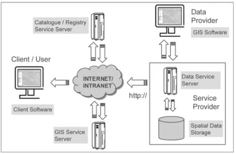
A Spatial Data Infrastructure should enable the discovery and delivery of spatial data from a data repository2, ideally via one or more web services. Additionally, it is often desirable that the data provider is able to (remotely) create and update spa-tial data stored in a repository. Hence, the basic software components of an SDI consists of (i) a software client that can display, query, and analyse spatial data, (ii) a catalogue service for the discovery, browsing, and querying of metadata or spatial services, spatial datasets and other resources, (iii) a spatial data service that enables the delivery of the data via the Internet, and/or processing services such as datum and projection transformations, (iv) a (spatial) data repository, and (v) GIS software (client or desktop) that permits the creation and maintenance of data (Fig. 1). The catalogue service (item ii above) functions in a similar manner to analogue directories such as the Yellow Pages. The extent of processing services (iii above) is somewhat unlimited, but transformation services are generally fundamental to a distributed system.
2.2 Important technical standards for spatial data distribution
Several technical standards defined by the Open Geospatial Consortium (OGC,opengeospatial.org) and the International Organization for Standardization (ISO 19xxx series, iso.org) play an important role in the dissemination and processing of spatial data. In general, these standards describe communication protocols be-tween data servers, servers that provide spatial services, and client software, which request and display spatial data. In addition, they define a format for the transmis-sion of spatial data. We identify the following OGC standards that are required to build an SDI:
2 For our purposes a data repository is a collection of spatial datasets, that may be stored in one
or more spatial databases, on one or more physical servers, i.e., a data warehouse. We assume that the repository is integrated and non-volatile.
• OGC data delivery standards: Web Mapping Service (WMS), Web Feature Service (WFS) and its transactional equivalent (WFS-T), and the Web Cover-age Service (WCS);
• OGC data format standards: Simple Feature Standard (SFS), Geography Markup Language (GML), Keyhole Markup Language (KML);
• OGC data search standards: Catalogue Service (CSW), Gazetteer Service (WFS-G); and
• Other OGC standards: Web Processing Service (WPS), Coordinate Transfor-mation Service (CTS), Web Terrain Service (WTS), Styled Layer Descriptor (SLD), Symbology Encoding (SE), Web Map Context (WMC).
The ISO Standard 19115 (Geographic Information – Metadata) is also important as it defines a schema for describing spatial data, and ISO 19119 (Geographic In-formation - Services) defines how spatial data and services should be described so that they are able to be searched by catalogue services (such as OGC’s Catalogue Service). Specifications developed by the World Wide Web Consortium (W3C) for data dissemination such as HTML, XML, SVG, SOAP, WSDL, etc., should also be considered (see Chapter 7 of the SDI Cookbook [9]). Further information on applicable and implemented standards can be found in [9,10,11].
3 Free and open source spatial software
Defining terms: free and open source - Software that is called ‘Free Software’ or ‘Free and Open Source Software’ (FOSS) is covered by a specific type of soft-ware license. This license needs to grant the softsoft-ware user at least the following four freedoms: (1) the freedom to run the program, for any purpose (e.g., no mat-ter if for educational or business purposes) (2) the freedom to study and adapt the program for one’s own needs, (3) the freedom to redistribute the software, and (4) the freedom to improve the software and to release these improvements to the public (see www.gnu.org/philosophy/free-sw.html). In this sense “free” takes on concepts of the public domain such that there are no rights to exclude. Hence, software that is (i) gratis, i.e. free-of-cost, and (ii) permits viewing of the source code does not automatically qualify as “free and open source” software. If the user’s rights include the right of independent use, of modification, and of free dis-tribution — only then — can the software be called “free” and “open source” software. With respect to this definition a distinction between the categories of free/gratis vs. commercial/paid for software is not entirely correct, since the free-doms outlined above do not prohibit a developer from attaching a cost to the dis-tribution and support of “free software”. For a discussion of free software licenses we refer the reader to Johnson [12], the Free Software Foundation web pages (fsf.org), and Steiniger and Bocher [13], who also discuss three common miscon-ceptions of the General Public License (GPL). In our software review, we in-cluded only software that comes with licenses that grant the four freedoms men-tioned above.
GIS software categories and literature on free GIS - Several categories of GIS software have been identified by Steiniger [14,15]. The classification includes: (i) desktop GIS, used for data creation, editing, analysis and map generation; and (ii) Spatial Database Management Systems (Spatial DBMS) that are used for the stor-age of data; (iii) web map server for the delivery of map like representations over the Internet; (iv) server GIS, that are used to remotely process, e.g., analyse, spa-tial data; (v) web GIS clients, to display and query spaspa-tial data stored at remote lo-cations that are only accessible via Internet or intranet; (vi) mobile GIS, which are most often used for data acquisition in the field; and finally (vii) GIS libraries and extensions, which provide special functions that can enhance standard (desktop) GIS capabilities, or be used to build customized GIS applications, including web mapping applications.
Reviews of Free and Open Source Software for GIS (FOSS4GIS) and its utility have become more common over the last three years as several free software solu-tions have matured to the point that they are able to replace proprietary software. An early assessment of FOSS4GIS focusing on SDIs was completed by Reid and Martin [4], who concluded in 2001 that there was great potential for the use of FOSS4GIS solutions that incorporated SDI components. FOSS4GIS software
re-views not related to SDIs but rather environmental GIS applications have been completed by Jolma et al. [16] and Steiniger and Hay [15]. Ramsey’s [17] general review of FOSS4GIS projects, Sanz-Salinas and Montesinos-Lajara [18] summary of major FOSS4GIS projects, and Steiniger and Bocher’s [13] as well as Don-nelly’s [27] recent evaluation of FOSS4GIS desktop projects may also be of inter-est to SDI implementers.
4 Free and open source spatial software for SDIs
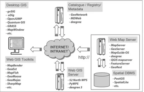
In the previous sections we have outlined the types of GIS software and the major software components that exist in a general SDI architecture. For the discussion below we have combined those categories and arranged the discussion as follows: (4.1) SDI server software: (4.1-A) web map servers (4.1-B) server GIS; (4.2) SDI spatial data storage: Spatial Data Base Management Systems (Spatial DBMS); (4.3) SDI registry/catalogue and metadata software; (4.4) SDI client software: (4.4-A) desktop GIS clients, (4.4-B) web-GIS development toolkits (see Fig. 2).
Fig. 2 FOSS4GIS Software that can be used in an SDI.
Our review below aims to focus only on the more established projects. For some categories we will also mention software under development if we believe the pro-ject could attract a wider user group. Due to page limits we will only list the soft-ware projects and not describe them in detail – and instead refer the interested
reader to the related project web pages and Sanz-Salinas and Montesinos-Lajara [18]. However, we try to give a general assessment for the software categories with respect to software advancement and use in comparison to proprietary soft-ware, and list in Table 1 the supported OGC/ISO standards for selected software.
4.1 SDI Server software
In the following we distinguish between two different categories of server soft-ware, web map and web-GIS servers, owing to their different usage (see [14,15]).
A - Web Map Servers for serving data and images – Web mapping services, i.e. servers, usually serve spatial data based on three OGC standards: WMS (or ISO 19128: 2005, Geographic Information – Web Map Services) for the display of maps as image, WFS for vector data, and WCS for raster data. Web map servers rarely allow interaction with the data in terms of processing or editing. However, if standards such as the OGC WPS (processing) and OGC WFS-T (editing) are implemented, then this is possible. The two best-known software distributions are (UMN) MapServer (mapserver.org) and GeoServer (geoserver.org). Both solu-tions are comparable to similar proprietary solusolu-tions with respect to their func-tionality. Autodesk also offers a widely adopted open source web map server, MapGuide Open Source (mapguide.osgeo.org), which has evolved out of Auto-desk’s proprietary MapGuide 6.5 software. A fourth server software, with a strong European user base, is the deegree server/application framework offered by lat/lon GmbH (wiki.deegree.org). deegree has been the reference implementation for sev-eral OGC standards [11].
All four web server products have been released for several years and are widely used in SDI settings. Often they have been the preferred choice, when compared to proprietary offerings, e.g. [19,20]. We also note the 2009 release of QGIS mapserver by the Quantum GIS desktop community (karlinapp.ethz.ch/qgis_wms). Finally, there are two REST based approaches that warrant mention, FeatureServer (featureserver.org), and GeoRest (code.google.com/p/georest). In a RESTful style service everything is treated as a resource and representations of resources can be uniquely addressed by a universal resource identifier (URI). Both systems offer WFS capabilities and provide vari-ous contemporary web formats such as GeoJSON, KML and GeoRSS.
B – Web-GIS Servers for data processing – These solutions are distinct from web map servers as they do not provide web mapping services, but rather they ex-pose GIS processing functionality that is typically offered by desktop GIS soft-ware - for example data analysis and transformation services. To use the process-ing functionality the software should support the OGC WPS standard (or ISO
19119: 2005, Geographic Information – Services), which in turn acts as our selec-tion criterion for this listing.
One solution that implements the WPS standard is 52N WPS software by 52° North (52north.org). Spatial analysis, i.e. processing functions, provided by the 52 North software stem from the Sextante project. 52 North also distributes two client plug-ins for the free desktop GIS’ uDig and JUMP / OpenJUMP. A further im-plementation of the WPS standard for server-side use is part of the deegree 3 framework (wiki.deegree.org). The software PyWPS implements the OGC WPS standard (pywps.wald.intevation.org) and enables access to a wide range of analy-sis functions for the desktop GIS GRASS. Finally, the new ZOO Project ( zoo-project.org) also aims to develop software to access and distribute WPS services.
4.2 SDI Data storage software: spatial DBMS
Spatial Database Management Systems (DBMS) are usually not developed as a software solution on their own, but rather developers add spatial capabilities to ex-isting free DBMS. The product with the largest user base is probably PostGIS (postgis.refractions.net). PostGIS adds spatial data types and analysis functions to the FOS database PostgreSQL (postgresql.org). PostGIS is currently used in high demand installations, for example by the French National Mapping Agency (IGN France), and it provides the most complete implementation of OGCs Simple Fea-ture Specification (OGC SFS) of any FOSS DBMS solution. Comparisons with proprietary Spatial DBMS, such as Oracle 10g Spatial, show that PostGIS is a comparable alternative when considering functionality, robustness, support and price (see [21]).
Two other FOSS DBMS projects include spatial data capabilities. They are the MySQL Spatial extension (mysql.com), which adds spatial support to MySQL, and the SpatiaLite project for SQLite (gaia-gis.it/spatialite). Currently MySQL Spatial provides a basic implementation of OGCs SFS for SQL standard, but query and analysis operations utilize (Minimum) Bounding Rectangles instead of true geometries. Hence, operations have lower precision and may not be useful for everyone [22]. SpatiaLite realizes conformance to the OGC Simple Features Specification by utilizing the functionality of the GEOS geometry library (trac.osgeo.org/geos).
In addition to the above, there are a number of projects adding spatial support to DBMS, that include (i) Hibernate (hibernatespatial.org), (ii) H2 DBMS (see the websites geoserver.org, orbisgis.org, and hatbox.sourceforge.net), and (iii) INGRES (community.ingres.com/wiki/IngresGeospatial). Also CouchDB (couchdb.org, [23]) and MongoDb (mongodb.org, [24]) have been used for storing spatial data. Both projects offer a JSON (JavaScript Object Notation) document-oriented database with query and indexing capabilities. However, there are
cur-rently no spatial extensions that we are aware of that enable native spatial queries in these ‘NoSQL’ database implementations.
Table 1 Selected OGC standards supported by some of the GIS software mentioned.
Software Category Software Selected Supported OGC & ISO Standards Web Map Server MapServer
GeoServer Deegree 3
Map Guide Open Source QGIS Mapserver WMS, WFS, WCS, SLD, WMC, GML WMS, WFS, WFS-T, WCS, SLD, GML, KML WMS, WFS, WFS-T, WFS-G, WCS, WMC, SLD, GML, WPS, CS-W WMS, WFS WMS, SLD Registry/ MetaData GeoNetwork Deegree 3 CADMEdit, MDweb
CS-W, ISO 19115:2003, Geographic Information - Metadata
see above, ISO 19115, ISO/TS 19139:2007, Geo-graphic Information – Metadata – XML Schema Implementation, ISO 19107: 2003, Geographic Information – Spatial Schema
ISO 19115
ISO 19115, ISO 15836: 2003, Information and Documentation – The Dublin Core Metadata ele-ment set)
Desktop GIS2 Quantum GIS OpenJUMP gvSIG uDig MapWindow GRASS WMS, WFS, SFS, GML, KML WMS, WFS1, SFS, GML, KML1, SLD, WFS-T1, WPS1 WMS, WFS, WFS-G, WCS, GML, KML, CS-W WMS, WFS, WFS-T, SFS, GML, SLD, WPS1 WMS1, WFS1 WMS, WFS, GML, WPS1 1
Supported via plug-in; 2After writing this article ILWIS Open 3.7 received WMS support.
4.3 SDI Registry/catalogue and metadata software
In our search for software falling under the registry/metadata category we found four projects. Three projects provide software to setup a server that functions as “yellow pages” like inventory for spatial data. The first project is GeoNetwork Opensource (geonetwork-opensource.org) funded and used by several large agen-cies including the Food and Agriculture Organization of the United Nations, the World Food Programme, the United Nations Environment Programme, and the United Nations Office for the Coordination of Human Affairs. MDweb ( mdweb-project.org) is a project initiated by research institutes in France and the software is used in several environmental projects and institutions. The deegree framework
(wiki.deegree.org) also provides metadata services for the creation, storage, query, retrieval and display of metadata. The fourth software is not a server-based cata-logue software, but a metadata editor for desktop computing: CatMDEdit (catmdedit.sourceforge.net). The software allows creation and editing of metadata for several types of GIS file formats and is used by a number of public agencies such as the EUs Statistical Office EuroStat, the National Geographic Institute of Spain and the French National Mapping Agency.
4.4 SDI Client software
A – Desktop GIS clients for data update and analysis - Desktop GIS can be considered the work horse of GIS software. As such, there are a number of FOSS projects that develop and maintain desktop GIS. Recent reviews [13,15, 27] identi-fy eight mature FOSS desktop GIS. We use the term “mature” to refer to software solutions that offer extensive software functionality, software support, and an in-ternational focus driven by both user and developer communities. In order to use desktop GIS in an SDI context the software should provide at least OGC WMS capabilities to ensure that it can act as an SDI client. As not all eight desktop GIS have WMS support our list is reduced to seven: (1) GRASS GIS (grass.osgeo.org), (2) Quantum GIS (qgis.org), (3) uDig (udig.refractions.net), (4) OpenJUMP (openjump.org), (5) MapWindow GIS (mapwindow.org), (6) gvSIG (gvsig.org), and (7) ILWIS Open (52north.org). More details on the capabilities of these soft-ware can be found in [13].
Besides these projects some more local or specialized projects exist, e.g., the KOSMO project with a focus on Spanish users (opengis.es). In addition, several newer projects can be found that currently have small user and developer com-munities, e.g., iGeoDesktop (deegree.org), OrbisGIS (orbisgis.org), and Puzzle GIS (puzzle-gis.codehaus.org).
B – Web-GIS development toolkits for browser-based clients – As an alterna-tive to desktop GIS software, sometimes referred to as a thick client, it is becom-ing more common to make use of a web browser-based thin client to display (and query) data. However, to construct a standard web browser for the display of spa-tial data requires additional functionality on either the client, the server, or both. Several toolkits are available that aid the development of web map pages - or complete spatial data portals.
A simple web map page contains usually only a data viewer with no advanced query or styling functions, although these can be added. To incorporate a simple interactive map the OpenLayers library (openlayers.org) provides an OGC WMS / WFS compatible spatial data viewer. The project OpenScales (openscales.org) provides another option with its Adobe Flex-based viewer. Several other map viewer projects exist or have existed, e.g., ka-Map, Chameleon, ModestMaps and
MapBuilder, but several of those projects joined the OpenLayers project [see 25]. Hence, there has been an increase in the adoption and development of OpenLayers recently. Two more viewers should be mentioned. The first is SLMapViewer (slmapviewer.codeplex.com), which provides a Microsoft Silverlight interface for MapServer users. The second viewer, MapBender (mapbender.org), is not only a viewer but a web mapping framework that provides functions for managing spatial data services as well, i.e., MapBender could be used to create an SDI portal.
Several development toolkits exist that include not only a viewer (often OpenLayers) but also other tools that help to build web map pages for display and query (or even editing) of spatial data. Projects that provide such frameworks in-clude: GeoMajas (geomajas.org), GeoExt (geoext.org), GeoMoose (geomoose.org), MapFish (mapfish.org), Mapstraction (mapstraction.com), and SharpMap (codeplex.com/SharpMap). If more complex web applications are to be developed, then it is also recommended that developers consider the use of Googles Web Toolkit (gwt.google.com) and Google Gears (gears.google.com). GeoTools (geotools.org) should also be considered to realize server side like GIS functionality and spatial data access.
6 Concluding remarks
Our software review shows that for all categories of GIS software required for the implementation of an SDI, a free and open software product is available. A more detailed examination also reveals that several free products are able to compete with proprietary software, in particular the web map server projects, the spatial DBMS PostGIS, and the data viewer OpenLayers. Indicators for competitiveness in these instances are the number of “real-world installations” and their use in high-demand environments. However, if an organization chooses to implement an SDI using FOSS, then the appropriateness of FOSS projects and software need to be assessed. Key criteria for such an assessment are: (i) functionality, (ii) support of common data distribution standards (e.g. OGC, ISO, CEN standards), (iii) sup-ported platforms (Windows vs. Linux, etc.), (iv) software reliability, (v) options for customization, (vi) distribution costs, (vii) installation and maintenance effort (incl. costs), (viii) training and support options including pricing [26]. For a first evaluation of the software it is recommended that adopters make use of GIS dis-tribution packages (for Linux), such as HostGIS (hostgis.com), or Virtual Machine GIS installations, such as GIS VM (gisvm.com) and OSGeo’s Arramagong (download.osgeo.org/livedvd/).
The licenses used by free and open source products ensure a low acquisition cost (typically no cost) for the software itself, and ensure that the software is cus-tomizable and adaptable to the SDI context. Hence, and with respect to the latter point, free and open source software often implement a wide set of (OGC) stan-dards, and if not, at least permit the implementation/addition of components that
are OGC/ISO standard compliant. The use of open source licenses allows an adopter to deploy SDI components to other locations at no additional cost, e.g., for horizontal scaling of a system. Finally, we note that helpful user and developer communities exist, and that support and maintenance options are offered by vari-ous companies, which are similar to those currently offered by proprietary soft-ware vendors. In summary, we see that FOSS4GIS softsoft-ware can provide a viable alternative to proprietary products - and we hope that our review helps to assess the utility of FOSS4GIS for SDIs.
Acknowledgments Parts of this work have been accomplished under a Phase IV GEOIDE pro-ject, #03. We are grateful for their funding. We thank the free GIS community, and Erwan Bo-cher and Markus Neteler for encouraging us to write this overview for the OGRS book.
References
1. Rajabifard A, Williamson IP (2001) Spatial data infrastructures: concepts, SDI hierarchy and future directions. Proceedings Geomatics 2001, Australia.
2. Crompvoets J, Bregt A, Rajabifard A, Williamson IP (2004) Assessing the worldwide devel-opments of national spatial data clearinghouses. Int J Geograph Inf Sci 18:665-689. 3. GeoConnections (2009) Status Report to the United Nations: Canadian Geospatial Data
Infra-structure. Ottawa: Natural Resources Canada.
4. Reid J, Martin F (2001) The open source movement and its potential in implementing Spatial Data Infrastructures. Proceedings International Symposium on Spatial Data Infrastructure, Melbourne, Australia. Available from: http://www.geo.unizh.ch/publications/ sstein/pubothers/reid_martin_foss_for_sdi_2001.pdf
5. May M, Merten S, Brauner J (2005) Open Source für Geodateninfrastrukturen – eine echte Al-ternative? Proceedings CORP 2004, Vienna, Austria.
6. Smits P (2003) INSPIRE: Infrastructure for Spatial Information in Europe. Presentation held on Sept. 17 2003, Open European Symposium on GI Interoperability, Segovia, Spain. 7. Granell C, Gould M, Manso MA (2009) Spatial Data Infrastructures. In: Karimi HA (ed)
Handbook of Research on Geoinformatics. New York: Hershey, pp. 36-41.
8. Kuhn W (2005) Introduction to Spatial Data Infrastructures. Presentation held on March 14 2005. Available from: http://www.docstoc.com/docs/2697206/Introduction-to-Spatial--Data-Infrastructures
9. GSDI (2009) Spatial Data Infrastructure Cookbook. Global Spatial Data Infrastructure Asso-ciation. Available from: www.gsdi.org/gsdicookbookindex
10. Smits PC, Düren U, Østensen O, et al. (2002) INSPIRE Architecture and Standards Position Paper. Available from: http://inspire.jrc.ec.europa.eu/index.cfm/pageid/241/documentid/809 11. Lupp M (2008) degree Free Software. In: Shekhar S, Xiong H (eds) Encyclopedia of GIS.
New York: Springer, pp. 235-239.
12. Johnson K (1999) Open-source software development. Available from: http://chinese-school.netfirms.com/computer-article-open-source.html
13. Steiniger S, Bocher E (2009) An overview on current free and open source desktop GIS de-velopments. Int J Geograph Inf Sci 23:1345-1370.
14. Steiniger S, Weibel R (2009) GIS software – a description in 1000 words. Available from: http://www.geo.unizh.ch/publications/sstein/gissoftware_steiniger2008.pdf
15. Steiniger S, Hay GJ (2009) Free and open source geographic information tools for landscape ecology. Ecol Inf 4:183-195
16. Jolma A, Ames DP, Horning N, et al. (2008) Free and open source geospatial tools for envi-ronmental modelling and management. In: Jakeman AJ, et al. (eds) Envienvi-ronmental Model-ling, Software and Decision Support. Amsterdam: Elsevier, pp. 163-180.
17. Ramsey P (2007) The state of open source GIS. In: FOSS4G 2007 Conference, Vancouver, BC, Canada, Available from: www.refractions.net/expertise/whitepapers/
18. Sanz-Salinas J-C, Montesinos-Lajara M (2009) Current panorama of the FOSS4G ecosystem. Upgrade 10(2):43-51.
19. Grothe M (2007) Implementing INSPIRE (principles) - towards an Enterprise SDI for Rijkswaterstaat. Presentation at 110th EuroSDR Meeting, Rotterdam, NL, Available from: www.eurosdr.net/meetings/110/presentations/h-5.pdf
20. Ramsey P (2009) The OpenGeo Architecture. Available from: opengeo.org
21. Greener S (2009) Oracle Spatial for PostGIS users – understand, isolate and migrate. Presen-tation at FOSS4G 2009 Conference, Sydney, AU, Available from: http://www.spatialdbadvisor.com/file_download/43/FOSS4G_2009_PostGISAndOracleSpati al.pdf
22. BostonGIS (2009) Cross Compare SQL Server 2008 Spatial, PostgreSQL/PostGIS 1.3-1.4, MySQL 5-6. Available from: bostongis.com
23. Mische V (2009) Geodata and CouchDB. Presentation at FOSS4G 2009 Conference, Sydney, AU. Available from: http://vmx.cx/blog/2009-11-17/geodata-and-couchdb.pdf
24. Corti P (2009) Using MongoDb to store geographic data. Available from: paolocorti.net 25. Adams T (2009) There is no alternative to OpenLayers…? Presentation at FOSS4G 2009
Conference, Sydney, Australia. Available from: http://maps.terrestris.de/dokuwiki/ do-ku.php?id=alternative_openlayers
26. Sveen AF (2008) Use of free and open source GIS in commercial firms. Masters thesis, Norwegian University of Technology and Science. Available from: spatialserver.net/osgis/ 27. Donelly FP (2010) Evaluating open source GIS for libraries. Library Hi Tech 28:131-151. 28. Clinton B. (1993) Coordinating geographic data acquisition and access: the national