Abstract— Most studies on providing evacuation guidance have targeted residents, with little being known about providing evacuation guidance for visitors to the area, such as tourists and business people. The purpose of this study targets the development of a system that supports the safe and efficient evacuation of tourists from disaster areas to specific safe destinations. The system models the evacuation behavior of tourists and then simulates the evacuation process when a specific evacuation guidance method is utilized. The system can therefore then compare and evaluate the effectiveness of the various types of evacuation guidance methods. The effectiveness of the system was verified by simulating an evacuation process utilizing a phased evacuation guidance method introduced in Kyoto, the most popular tourist city in Japan.
Index Terms—evacuation simulation, tourist, evacuation guidance
I. INTRODUCTION
There is a possibility that a large earthquake, such as the Tonankai and Nankai Earthquakes, Metropolitan area Inland Earthquakes, will occur in the near future. The 2011 Tohoku Earthquake, which occurred off the Pacific coast, and resulting Fukushima Daiichi nuclear accident on the 11th of March in 2011 have led to public concern over seismic measures increasing. Both the central Japanese and local governments have been taking various countermeasures against a disaster occurring but they are now being re-examined based on findings from the aforementioned earthquake.
In the meantime the government has positioned tourism as a major economic growth area [1]. The Tourism Nation Promotion Basic Law came into effect in 2007, and the number of tourists has subsequently been increasing, although the quake will result in a decrease the number of tourists over the short term.
Most countermeasures against disasters target residents and rarely non-residents, such as tourists and commuters. Regional disaster prevention plans were examined at the
Manuscript received July 13, 2011; revised August 5, 2011. This work was supported in part by a grant from the Strategic Research Foundation Grant-aided Project for Private Universities made available by the Ministry of Education, Culture, Sport, Science, and Technology, Japan (MEXT), 2010-2014 (S1091040), and as part of Kyoto city funded research.
Y. Nakatani belongs to the Graduate School of Science and Engineering, Ritsumeikan University, Kusatsu city, Shiga, 525-8577 Japan (phone:+81-77-561-5932;fax:+81-77-561-5203;e-mail:[email protected] ei.ac.jp).
S. Kinugasa belongs to the Graduate School of Science and Engineering, Ritsumeikan University, Kusatsu city, Shiga, 525-8577 Japan (phone:+81-77-561-5932;fax:+81-77-561-5203;e-mail:[email protected] mei.ac.jp).
prefectural-level in Japan. 11 out of 30 prefectures were consequently identified as including tourists, but in very little detail.
Countermeasures against disasters aimed at tourists not only need to protect them, as they can be both physically and psychologically vulnerable to damage, but also need to show how important they are to the rest of the world. Japan is a disaster-prone country and hence disaster countermeasures have been studied a lot, with the secure departure of tourists proving the effectiveness of the countermeasures. Some people are also afraid that publicizing countermeasures could result in the misunderstanding of the area being dangerous. However, disaster countermeasures can be significant to areas in that the number of tourists they attract can decrease if they are severely damaged by disasters. For example, after 2004 Indian Ocean earthquake and tsunami the number of tourists from Japan temporarily decreased by 95%, and is still yet to have completely recovered. The time needed for the tourist industry to recover can take a lot more time than most people think. Countermeasures against disasters being in place for tourists can therefore protect not only tourists but also the local tourism industry and indeed the tourism reputation of Japan. This then makes, from the viewpoint of BCM (Business Continuity Management), countermeasures against disasters being in place for tourists very important.
The following are common features of tourists:
z Tourists have a tendency to feel anxiety because they are not familiar with the area and know little about evacuation centers and routes. This can also result from them having very little access to local information on disasters and resulting damage.
z If they are not with their families they are likely to wish to contact them via phones, e-mail, or other media.
z They usually wish to return home, thus resulting in congested railway stations.
z They have a tendency to ignore important information such as evacuation instructions, and it can be difficult for them to appreciate the danger.
z They are typically not prepared to seek refuge.
z They get stressed from dealing with the many other tourists, and thus easily tire both mentally and physically.
z Foreigners find it difficult to access local information as most local information is provided aurally in Japanese. The features listed above typically appear prominently in those instructions.
Confusion can often therefore result because tourists are unfamiliar to the area and have access to very little local information. The possibility of a secondary disaster
Evaluation Support System of
Large Area Tourist Evacuation Guidance
occurring depends not only on the scale of the disaster or the countermeasures in place but also the situation with evacuation procedures. Any number of tourists not following the evacuation instructions could result in extensive damage, thus making it very important that the appropriate evacuation guidance and design guidelines are available. Studies on regional disaster countermeasures need to include collecting and distributing disaster information and accurately leading evacuees to their destination in addition to the hardware side of disaster prevention facilities and equipment.
To aim in solving these problems the purpose of this study is to provide administrative staff with an environment that they can then use to verify safety guidance via a computer in quickly leading tourists, in various types of areas, to a safe destination. Residents of tourist areas would also be able to find refuge. This requires the method of evacuation to be examined in view of the possible situations, which could include damage to public transportation, crowded traffic roads that prevent evacuees from walking to a safe destination, the risk of sediment disasters, and the weather conditions.
II. RECENT LARGE AREA TOURIST EVACUATION GUIDANCE
This section outlines some of the existing research on large scale evacuation guidance methods.
A. Transcendent Evacuation Guidance System
This system, created by Ishida and some researchers at Kyoto University, involves an instructor conducting evacuations for evacuees via a mobile phone with a GPS function [2]. The location of evacuees can be constantly supervised using location data provided by GPS and replicated in a virtual city called FreeWalk, which provides a bird's-eye view of the area. The instructor can constantly observe the behavior of evacuees using FreeWalk while providing them with instructions via a mobile phone.
B. Dynamic Emergency Navigation System
The Nozaki and Wakayama University researcher’s system enables evacuees to receive evacuation guidance via disaster information being input using a mobile phone [3]. A number of wireless devices therefore need to be situated throughout the area for use in transmitting the evacuation information. Bluetooth is used for the communication between the mobile phones and wireless devices.
C. Phased Evacuation Guidance
The phased evacuation guidance method was proposed by Nakatani and involves evacuees being guided to a temporary shelter, not in real-time, however, but in a phased manner [4]. It features “staging posts” for temporary refuge for evacuees on the way to their destination.
The staging posts function as a buffer zone in thus preventing tourists from rushing into the central parts of cities and thereby realizing the fast evacuation of tourists from dangerous areas to safer areas. University campuses throughout Kyoto are candidate sites for use as the staging posts. Large shrines and temples are also candidate sites, as long as they were not overly damaged.
Cooperators in disaster areas, such as souvenir shop staff and tourist agents, are requested to send an outline of the situations to the emergency management center. The
emergency management center then determines and changes evacuation instructions using their reports before sending them on. The cooperators guide evacuees to safety according to the instructions they receive.
The effectiveness of the phased evacuation guidance method is yet to have been verified in a real situation but was examined at Kiyomizu temple in Kyoto via a computer simulation.
III. SYSTEM CONSTRUCTION A. Approach
The administrative staff will need to be supported with information systems as visitors will not be able to evacuate themselves without accurate evacuation guidance. However, it can be difficult for a limited number of administrative staff to collect the necessary information, make decisions, and transmit evacuation instructions. The administrative staff would also find it difficult to support all the tourists in large damaged areas. An evacuation support system is therefore needed to support them. The system is also needed by the residents in the area.
Before designing an evacuation support system it is important to decide an appropriate method of evacuation guidance in advance. Various methods and systems of evacuation guidance have been proposed to date. The design of an appropriate evacuation guidance method requires understanding of the situations that can actually occur when specific guidance methods are adopted. Large-scale evacuation experiments are impractical, with computer simulation appearing to be the most effective.
Simulating evacuation behavior has been investigated in various fields. Recently, RoboCup Rescue simulation as a large-scale Multi agent system has been noticed [5]. However, no simulator has been investigated that can be used to verify the effectiveness of evacuation guidance methods for tourists. We therefore developed a new system that simulates the evacuation behavior of tourists in a large area using a specific method and then quantitatively evaluated the results.
B. Development Environment
We developed the system using the JavaScript language on a Windows PC. The map administration system utilizes the Google Maps API, which makes the function of the map information service provided by Google available for use outside over a network.
C. System Screen Configuration
The following displays use of the system (Figure 1).
Fig.1: System screen
① Disaster information input space:
The disaster information is entered here, including the
①
②
③
origin, destination, transit point, and number of evacuees. The origin is the start point of the evacuation and the destination the end point. The transit point is an intermediate point between the origin and the destination. If this input space is empty the evacuation route would be the shortest path from the origin to the destination. If there is input in the space, however, the route is the shortest path through the input space. The number of evacuees equals the number at the origin. The origin, destination, transit point and number are considered one data set. Inputting this information then decides the evacuation route. In brief, this process decides which shelter to go to through which route for each destination.
② Simulation display space:
This space shows the evacuation route and evacuation behavior graphically. Figure 1-②* shows the enlarged screen of Figure 1-② after start of the simulation. This figure shows the transition of evacuees from Kiyomizu Temple to Kyoto station. Evacuees in transit are shown as a thick line. One minute in real time is one second in the simulation. Evacuees may gather together at some positions depending on the location. There are 2 conditions that change their density in the system: One being when they meet and the other when the width of the road changes. Evacuees gathering together can delay their moving speed. ③ Circumstance display space:
This space shows the evacuation circumstances, including the number of evacuees in the area.
④ Operate button:
This space is used to start, stop, pause, and resume the simulation.
D. System motion
[image:3.595.322.536.115.344.2]The following flowchart is used after the simulation starts (Figure 2).
Fig.2: Flowchart after start of the simulation
Move Evacuees shows the transition of evacuees from each step to the next. A step is the minimum unit from the origin to the destination. Each step includes the next step position, distance, and width of the road. The move is calculated based on this information and transports evacuees in each step from the last step position to the next step position. This move results in a line being drawn from the last step to the next step, thus depicting how the evacuees move in a bold line.
Evacuation Complete shows that the evacuees in the last step have reached their destination.
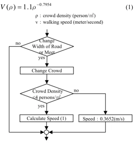
The system includes conditions that change their Speed of Movement, with that speed depending on density of the crowd. The Crowd density shows the number of persons per 1㎡, and is calculated based on the width, distance and
number of evacuees in a step area. A high crowd density results in a decrease in the walking speed and thus a delay in the evacuation. The following provides the speed equation (1) and the flowchart after start of the simulation (Figure 3).
7954 . 0
1
.
1
)
(
ρ
=
ρ
−V
(1) ρ:crowd density (person/㎡)v:walking speed (meter/second)
Fig. 3: Flowchart of change in speed
Togawa revealed the relationship between the density and the walking speed. Fruin [6] discovered that 4 persons per 1㎡ leads to a sharp decrease in the walking speed. In this system the walking speed is calculated using that information, with Equation (1) being based upon it.
In the system the walking speed is changed when the width of the road widens or when two evacuee groups meet and merge (Figure 3). A narrow road results in an increase in the crowd density. The size of the step then changes but the number of persons in each step does not. Evacuation groups merging also increases the density. The number of persons in a step changes but the size of the step does not. If the density is lower than 4(persons/㎡) the walking speed depends on Equation (1) but if the density is higher than 4 the walking speed is 0.3652(meter/second), and the density remains at 4. The length of crowd then increases, revealing that the crowd extends backward when it has passed the limit.
The current version of the system does not completely take into consideration changes in the width of the road and the merging of two groups. When two groups do merge the walking speed does not slow down. The length of a group also does not change even when the width of the road changes. Those defects are currently being improved upon in thus obtaining more realistic results.
IV. SYSTEM EVALUATION
The effectiveness of the system was examined using Japan’s most popular tourist city of Kyoto. The phased evacuation guidance method was proposed by Nakatani for use in the tourist evacuation guidance field in Kyoto. We then examined it by using the method in our system and obtained an evaluation of the results from some experts.
The system does not include all the features yet but is at the level where it can be evaluated.
Change Crowd
Calculate Speed (1) Speed:0.3652(m/s) no
yes
yes
no Change Width of Road
or Meet
Crowd Density <4 persons/㎡
Start
Evacuation Complete
Move Speed Change (Figure 4) Move Evacuees
End yes
[image:3.595.93.260.464.586.2]A. Kyoto
The tourist area of Kyoto was selected for use in evaluating the system. Kyoto is world-famous tourist city and was visited by 50,210,000 tourists in 2008. Tokyo Disney Land and Disney Sea are visited by about 27,000,000 tourists annually, thus making it obvious that Kyoto is the most famous tourist city.
The firm possibility also exists that an earthquake will occur in Kyoto. According to a report from the committee of The Headquarters for Earthquake Research Promotion of the government, the probability of ground motion, equal or larger than a seismic intensity of low 6 occurring within 30 years in Kyoto city is more than 3% [7]. The earthquake scale of most the remarkable Hanaore fault is supposed to be 7.4 on the Richter scale. The probability of this earthquake occurring is about 0 to 0.6 percent, a high level for Japan. The probabilities of Tonankai and Nankai Earthquakes occurring relative to the Nankai Trough are 60% and 55%, respectively, which are very high when compared to the probabilities of other earthquakes. The earthquake is assumed to cause a ground motion of a seismic intensity of low 6 in Kyoto.
B. Simulation Conditions
The simulation took place using the conditions in Table 1. Figure 4 shows the locations of the Origins and the Staging posts.
TABLE1 SIMULATION CONDITIONS
No. Origin Staging Post (persons)Tourists
1 Kiyomizu Temple(m) Maruyama Park(j) 12,000
2 Arashiyama(a) None 9,500
3 Kinkakuji Temple(d) Ritsumeikan Univ.(c) 6,700
4 Ginkakuji Temple(f) None 5,500
5 Nanzenji Temple(i) Okazaki Park(h) 5,300 6 Yasaka Shrine(k) Maruyama Park(j) 4,200
7 Koudaiji Temple(l) Maruyama Park(j) 4,100
8 Nijo Castle(e) None 4,000
9 Heian Shrine(g) Okazaki Park(h) 3,200
10 Ryuuanji Temple(b) Ritsumeikan Univ.(c) 1,700
Destination JR Kyoto station(n)
Walking Speed 3 (km/hour)
Width of Road 4 (meter)
Origins denote the eight most popular tourist sites in
Kyoto.
Staging posts denote safe evacuation areas chosen as
temporary shelters in Kyoto city [8]. These places were selected for their distance from tourist sites and capacity.
Tourists denote the number of tourists at each site, and
were calculated based on the number of visitors per hour. The actual number of tourists was counted at Kiyomizu Temple on a Saturday and Sunday in November 2010. With the other sites the number of tourists was calculated using a comparison with Kiyomizu temple and based annual tourist statistics [9].
The smallest width of road of 4 meter for evacuation
routes in Kyoto was adopted. The walking speed was
considered to be 3 (km/hour) and constant.
The destination was considered to be JR Kyoto station,
which is typically crowded with tourists when the railway resumes operating after a suspension.
[image:4.595.309.546.142.286.2]The evacuation route in the simulation shows the shortest walking route from the origin to the destination. The narrow road could become impassable, but this simulation ignored that.
Fig. 4: position of tourist sites and staging posts in Kyoto
z The evacuation route of crowd Nos. 1, 6, and 7: Kiyomizu temple (m) is the most popular tourist site in Kyoto. Maruyama Park (j) is a safety evacuation area that was selected as a temporary shelter by Kyoto city. This park is near Yasaka Shrine (k) and Koudaiji Temple (l). The path from Kiyomizu to Maruyama Park crosses both Sanenzaka Street and Ninenzaka Street. The two streets are narrow and sloped with a number of old wooden houses, and therefore not suitable for use in evacuating in an earthquake.
However, if evacuees need to aim for Maruyama Park the possible routes include only the abovementioned route or Todaiji Street. Todaiji Street typically has a high volume of traffic and thus severe congestion can be assumed to occur in a disaster. The route from Kiyomizu to Maruyama Park therefore only has Sanenzaka Street and Ninenzaka Street as possible options.
z The evacuation route of crowd Nos. 3 and 10:
Ritsumeikan University (c) is one of the largest evacuation areas in Kyoto and is near Kinkakuji (d) and Ryuuanji Temple (b).
z The evacuation route of crowd Nos. 5 and 9:
Okazaki Park (h) is a safe evacuation area selected as a temporary shelter by Kyoto city, and is near both Heian Shrine (g) and Nanzenji Temple (i). Okazaki Park and Maruyama Park are in the same direction.
z The evacuation route of crowd Nos. 2, 4, and 8: These lead directly to Kyoto station (n) without passing through any staging posts.
C. Results of Simulation
Table 2 shows the results of the simulation.
Time denotes the elapsed time from the start of the
simulation. No. denotes the number in Table 1. Numbers
with asterisks denote the new number of evacuees that have gathered at staging posts. Position denotes the position
(Figure 4) of Circumstances. Positions with asterisks
denote the intersection in front of the position. “Evacuation start” denotes that the first evacuee line has started evacuating. “Evacuation end” denotes that the end evacuee line has reached the destination. “Meet” denotes that the first evacuee line has come across another evacuee line
a 1km
1mile b
c d
e
f
g h
i j k
l
m
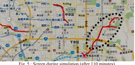
during an evacuation. For all evacuees to reach Kyoto station a total of 273 minutes (4 hours 33 minutes). Figure 5 shows the circumstances on the system screen after 110 minutes.
TABLE2 RESULT OF SIMULATION
Time
(minute) Circumstance No. Position
0 Evacuation start 1-10
53 Reach pausing space 5,9 1* h
62 Meet 4,1* h*
68 Reach pausing space 3,10 2* c
93 Reach pausing space 1,6,7 3* j
97 Evacuation end 8 n
110 Meet 3*,(4,1*) k*
176 Evacuation end 4 n
195 Evacuation end 1* n
250 Evacuation end 2 n
268 Evacuation end 2* n
273 Evacuation end 3* n
273 Simulation end
D. Considerations
The results of the simulation will now be discussed as follows:
z The total evacuation requires 4 hours and 33 minutes. A feature of tourists in Kyoto is the high proportion of middle-aged and older women. The evacuation method therefore results in those women having to travel quite a long distance. Several breaks are required along the way to the destination.
z Many evacuees from Maruyama Park obstruct evacuees from Ginkakuji Temple and Okazaki Park (dotted line in Figure 5), thereby resulting in a long line of evacuees and dangerous traffic combined with severe vehicle congestion. The timing of the two evacuee groups therefore needs to be considered.
z There are only narrow downslopes from Kiyomizu Temple and the surrounding area to a major road, thus making it very dangerous for the very young and aged people.
[image:5.595.50.287.625.739.2]z The intersection in front of Yasaka Shrine has a tendency to be crowded with many evacuees and dotted line in Figure 5). Merging in this place could be very dangerous from the viewpoint of secondary disasters occurring.
Fig. 5 : Screen during simulation (after 110 minutes)
E. Evaluation of Experts
The results were evaluated by two persons from the
Kyoto City Fire Department with regard to the
effectiveness of the system, with the result being they considered it effective. Table 3 provides their opinions.
TABLE 3
OPINIONS OF KYOTO CITY FIRE DEPARTMENT STAFF No. Opinions
1. Change evacuation route depending on environmental disaster.
2. Consider evacuation method usingemergency transportation route.
3. Consider both width of road and shortest path.
4. Change the environmental disaster depending on scale of earthquake.
1. It is rather difficult for the administrative staff to be able to completely predict what will happen in earthquakes, and therefore the system needs to take various situations into consideration in verifying various evacuation guidance methods.
2. The administrative staff proposed use of an emergency transportation route for the evacuation because emergency transportation routes are only for public use and unavailable to general vehicles. This assures the safety of the evacuation to a certain level. This is also related to the next 3.
3. The width of roads must be more than 6 meters to avoid congestion. The widest and shortest paths need to be designated.
4. For example, a road may not be useable because of the collapse of buildings or fire. The system needs to take such possible dangers into consideration.
V. CONCLUSION
This paper shows the importance of prevention disaster for tourists, the necessity of the system when considering appropriate evacuation methods in large disaster areas, the structure, and an evaluation of the system. In the future we would like to develop a detailed behavioral model that includes meets, splits, stops and slowing of an evacuee line with psychological factors taken into consideration. We then hope to develop and evaluate the system with the help of an expert. The system is applicable to not only Kyoto city but also other tourist cities. First of all, we are considering applying the system in Kyoto city.
REFERENCES
[1] Japan Tourism agency, Tourism Nation Promotion Basic Law. http://www.mlit.go.jp/kankocho/en/kankorikkoku/kihonhou.html. (refer July.10.2011)
[2] H. Itou, H. Nakanishi, S. Koizumi and R. Ishida, Transcendent Communication : Location-based Navigation for a Large Scale Public Space, Proceedings of Computer Human Interaction 2004, CHI2004, 24-29 April, 2004, Vienna, Austria, pp.655-662.
[3] K. Nozaki, et al., A Proposal for Dynamic Emergency Navigation System in Disasters, Proceedings of The Special Interest Group Technical Reports of IPSJ,2007, 2007-DBS-141 (29),pp.185-190.(In Japanese)
[4] Yoshio Nakatani, A verification and research report on collecting and making assistance information available on tourist’s disaster prevention, March, 2011, pp.62-66.(In Japanese)
[5] RoboCup Rescue, RoboCup Rescue Agents Simulation Project. http://www.robocuprescue.org/agentsim.html. (refer July.10.2011) [6] John J. Fruin, Pedestrian planning and design, 1971, pp.39-43. [7] The Headquarters for Earthquake Research Promotion: National
seismic Hazard Maps for Japan, 2005.
[8] Kyoto City Prevention Disaster Center, List of Safety Evacuation Areas, 2010. (in Japanese)