IJEDR1401168
International Journal of Engineering Development and Research (www.ijedr.org)932
1[email protected]________________________________________________________________________________________________________ Abstract—In order to find out the current location of the other person, we need to call the person where about his location. We proposed the system that will help to get the current location as a text and route navigation details of the other person. User will get a push notification whenever searching person are in minimum distance. User can track their location as well as other person location using mobile number. User can get more than one person location by giving their mobile number. Mobile Application can display and maintains the list of current location of the User and the other person as date wise with time. Using Google maps, user can find its route as well as distance and time to reach between other person.
Index Terms— Android Mobile devices, Google maps API, A-GPS, Web service.
________________________________________________________________________________________________________
I.INTRODUCTION
Tracking system is used to track the person location to know about exact location of that person. For tracking, Internet service, GPS or GLONASS is important to present inbuilt within the android Smartphone.. In existing system, user can view thier location as well as other person location on a Google maps so, user may lost the location information of the other person whenever the user internet get disconnected. In a proposed system, User can view the location information as a text in a list view, text contains exact street address of the person with pin code. Tracking information could be maintained as a history in a web server. User can see the route between locations of the other person by overlay the Google map application.
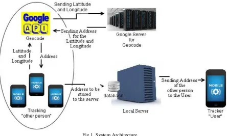
Fig 1. System Architecture. II.A-GPS
IJEDR1401168
International Journal of Engineering Development and Research (www.ijedr.org)933
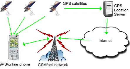
Fig 2. A-GPS working system. III.WEB SERVICES
The A web service is any piece of software that makes itself available over the internet and uses a standardized XML messaging system. XML is used to encode all communications to a web service. Web service is independent of operating systems. Web services are built on top of open standards such as TCP/IP, HTTP, Java, HTML, and XML.
XML plays User interface in Android. JSON or JavaScript Object Notation plays a vital role to get the information from and to the web server. JSON is used when writing JavaScript based application which includes browser extension and websites. JSON format is used for serializing and transmitting structured data over network connection.
Web services can be activated using HTTP requests.
It uses SOAP over HTTP protocol for the communication. PHP or Hypertext Preprocessor is a widely used open source general purpose language that is especially used for web development and also for server application.
IV.IMPLEMENTATION AND METHODOLOGY
T
racking the location is based on Location Based Services. Application can access Google API geocode services to get the location address of the person. Application can request for periodic update of the device location information. Application is run in a background service.Android Location Class
There are four classes to retrieve the Location Information of the user:
a) Location Manager- This class provides access to the location service and get the best Location provider network/GPS as per the situation.
b) Location Provider- This class provides reports about geographical location of the device.
c) Location Listener- This class provides callback method when location gets changed. The Listener object has to be registered with the Location Manager class.
Tracking User Location
User location is get tracked whenever User clicks the start tracking button in a mobile application. The service starts running in a background. If mobile has A-GPS, an application takes location information from network service otherwise it takes from GPS to read the Latitude and Longitude.
Geocoding is the process of finding associated latitude and longitude from other geographic data such as street addresses or ZIP codes. With Geographic coordinates the features can be mapped and entered into Geographic Information Systems by Google maps API. JSON will get those address information to the application from the Google server and that is send or store it to the Local server like PHP server. User can stop the service by clicking the stop button.
By the use of the mobile number, User can view the other person location those person location information will be fetched from the local server that is already saved.
Route MAP
By using the overlays on Google map, displays the route navigation between the user and the other person.
String uri= String.format (Locale.ENGLISH, "http://maps.google.com/maps?saddr=%f,%f&daddr=%f,%f", sourceLatitude, sourceLongitude, destinationLatitude, destinationLongitude);
Intent intent = new Intent(Intent.ACTION_VIEW, Uri.parse(uri));
intent.setClassName ("com.google.android.apps.maps", "com.google.android.maps.MapsActivity"); startActivity(intent);
Travel direction and searcher
Travel direction module is used to know about the route between the User location and the destination, user has to give the destination address. Searcher module is used to search ATM,Hospital,etc. nearby location.
IJEDR1401168
International Journal of Engineering Development and Research (www.ijedr.org)934
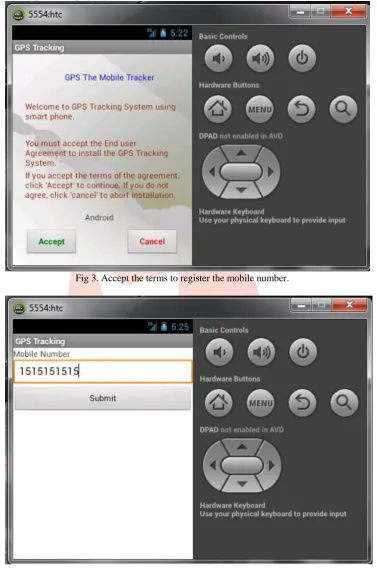
Fig 3. Accept the terms to register the mobile number.IJEDR1401168
International Journal of Engineering Development and Research (www.ijedr.org)935
Fig 5. Display of first internt of Tracking.Figure 5 shows whenever user clicked the start button, service will start and get the location information of the user and store it into the local server.
Fig 6. Giving mobile number to get the location.
IJEDR1401168
International Journal of Engineering Development and Research (www.ijedr.org)936
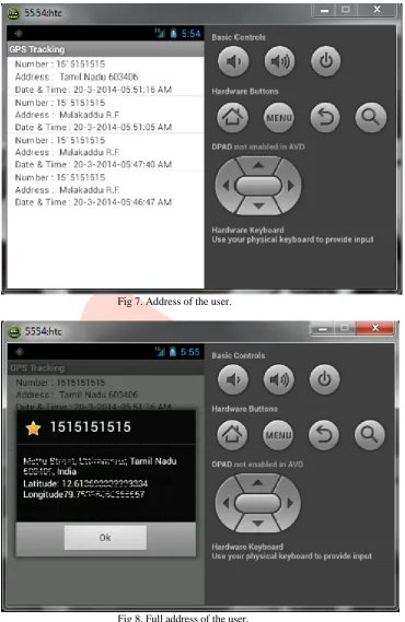
Fig 7. Address of the user.Fig 8. Full address of the user.
IJEDR1401168
International Journal of Engineering Development and Research (www.ijedr.org)937
Fig 9. Route Map between user and the other person.Figure 9 shows the route navigation between the user “location A point” and the other person location “ location B point”.
Fig 10. Notification.
Figure 10 shows the notification,whenever the user and the other are in minimum location that is geocordinates of the user matches with the geocordinates of the other person, Server will send the notification which contains other person mobile number as well as address.
VI.CONCLUSION
IJEDR1401168
International Journal of Engineering Development and Research (www.ijedr.org)938
http://developer.android.com/reference/android/location/LocationManager.html
[6] JSON Object http://www.androidsnippets.com/executing-a-http-post-request-with-httpclient