GPS
FOR
by Joel McNamara
GPS
FOR
111 River Street Hoboken, NJ 07030-5774
Copyright © 2004 by Wiley Publishing, Inc., Indianapolis, Indiana
Published by Wiley Publishing, Inc., Indianapolis, Indiana
Published simultaneously in Canada
No part of this publication may be reproduced, stored in a retrieval system or transmitted in any form or by any means, electronic, mechanical, photocopying, recording, scanning or otherwise, except as permitted under Sections 107 or 108 of the 1976 United States Copyright Act, without either the prior written permis-sion of the Publisher, or authorization through payment of the appropriate per-copy fee to the Copyright Clearance Center, 222 Rosewood Drive, Danvers, MA 01923, (978) 750-8400, fax (978) 646-8600. Requests to the Publisher for permission should be addressed to the Legal Department, Wiley Publishing, Inc., 10475 Crosspoint Blvd., Indianapolis, IN 46256, (317) 572-3447, fax (317) 572-4355, e-mail: [email protected]. Trademarks:Wiley, the Wiley Publishing logo, For Dummies, the Dummies Man logo, A Reference for the Rest of Us!, The Dummies Way, Dummies Daily, The Fun and Easy Way, Dummies.com, and related trade dress are trademarks or registered trademarks of John Wiley & Sons, Inc. and/or its affiliates in the United States and other countries, and may not be used without written permission. All other trademarks are the property of their respective owners. Wiley Publishing, Inc., is not associated with any product or vendor mentioned in this book.
LIMIT OF LIABILITY/DISCLAIMER OF WARRANTY: THE PUBLISHER AND THE AUTHOR MAKE NO REP-RESENTATIONS OR WARRANTIES WITH RESPECT TO THE ACCURACY OR COMPLETENESS OF THE CON-TENTS OF THIS WORK AND SPECIFICALLY DISCLAIM ALL WARRANTIES, INCLUDING WITHOUT LIMITATION WARRANTIES OF FITNESS FOR A PARTICULAR PURPOSE. NO WARRANTY MAY BE CRE-ATED OR EXTENDED BY SALES OR PROMOTIONAL MATERIALS. THE ADVICE AND STRATEGIES CON-TAINED HEREIN MAY NOT BE SUITABLE FOR EVERY SITUATION. THIS WORK IS SOLD WITH THE UNDERSTANDING THAT THE PUBLISHER IS NOT ENGAGED IN RENDERING LEGAL, ACCOUNTING, OR OTHER PROFESSIONAL SERVICES. IF PROFESSIONAL ASSISTANCE IS REQUIRED, THE SERVICES OF A COMPETENT PROFESSIONAL PERSON SHOULD BE SOUGHT. NEITHER THE PUBLISHER NOR THE AUTHOR SHALL BE LIABLE FOR DAMAGES ARISING HEREFROM. THE FACT THAT AN ORGANIZATION OR WEBSITE IS REFERRED TO IN THIS WORK AS A CITATION AND/OR A POTENTIAL SOURCE OF FUR-THER INFORMATION DOES NOT MEAN THAT THE AUTHOR OR THE PUBLISHER ENDORSES THE INFOR-MATION THE ORGANIZATION OR WEBSITE MAY PROVIDE OR RECOMMENDATIONS IT MAY MAKE. FURTHER, READERS SHOULD BE AWARE THAT INTERNET WEBSITES LISTED IN THIS WORK MAY HAVE CHANGED OR DISAPPEARED BETWEEN WHEN THIS WORK WAS WRITTEN AND WHEN IT IS READ.
For general information on our other products and services or to obtain technical support, please contact our Customer Care Department within the U.S. at 800-762-2974, outside the U.S. at 317-572-3993, or fax 317-572-4002.
Wiley also publishes its books in a variety of electronic formats. Some content that appears in print may not be available in electronic books.
Library of Congress Control Number: 2004102594
ISBN: 0-7645-6933-3
Manufactured in the United States of America
10 9 8 7 6 5 4 3 2 1
About the Author
Joel McNamarafirst got involved with digital maps in the early 1980’s. At the time he was studying archeology and instead of going out and playing Indiana Jones, he found himself in front of a computer monitor trying to predict where archeological sites were located based on LANDSAT satellite data.
The lure of computers ultimately led to his defection from academia to the software industry, where he worked as a programmer, technical writer, and manager; eventually ending up at a rather large software company based in Redmond, Washington. Joel now writes and consults on technology he finds interesting, such as GPS and digital maps.
Over the years he’s had practical experience using GPS and maps for wild-land firefighting, search and rescue, and disaster response and planning. He’s also an avid user of the great outdoors (which means there’s way too much gear in his garage), competes in adventure races and other endurance sports, and so far has always found his way back home. In his spare time he volun-teers for a federal Disaster Medical Assistance Team.
Author’s Acknowledgments
First off, thanks to my wife, Darcy, for her support during my work on this book, especially for putting up with all of the maps, CD-ROMs, cables, manu-als, and GPS receivers scattered all over the house during the duration.
Next on the list are the folks at Wiley, including Katie Feltman, my acquisi-tions editor and Pat O’Brien, my project editor. And a special note of appreci-ation to GPS and map guru Gavin Hoban, who diligently served as my technical editor.
I’d also like to thank the following manufacturers for supplying review copies of their products to write about: DeLorme (Caleb Mason), Endless Pursuit (Jack Robson), Lowrance (Steve Wegrzyn and Luke Morris), Magellan (Angela Linsey-Jackson), Maptech (Martin Fox), Microsoft, National Geographic, and TopoFusion (Scott Morris). I especially appreciate the help from the folks named in the parentheses who went above and beyond the call of duty in answering questions and providing assistance.
Some of the people who helped bring this book to market include the following:
Acquisitions, Editorial, and Media Development
Project Editor:Pat O’Brien
Acquisitions Editor:Melody Layne
Copy Editor:Teresa Artman
Technical Editor:Gavin Hoban
Editorial Manager:Kevin Kirschner
Media Development Manager: Laura VanWinkle
Media Development Supervisor: Richard Graves
Editorial Assistant:Amanda Foxworth
Cartoons:Rich Tennant (www.the5thwave.com)
Composition
Project Coordinator: Adrienne Martinez
Layout and Graphics: Amanda Carter, Andrea Dahl, Lauren Goddard, Lynsey Osborn, Heather Ryan
Proofreaders: Laura Albert, Brian H. Walls, TECHBOOKS Production Services
Indexer:TECHBOOKS Production Services
Publishing and Editorial for Technology Dummies
Richard Swadley,Vice President and Executive Group Publisher
Andy Cummings,Vice President and Publisher
Mary C. Corder,Editorial Director
Publishing for Consumer Dummies
Diane Graves Steele,Vice President and Publisher
Joyce Pepple,Acquisitions Director
Composition Services
Gerry Fahey,Vice President of Production Services
Contents at a Glance
Introduction ...1
Part I: All About Digital Maps ...9
Chapter 1: Getting Started with Digital Maps ...11
Chapter 2: Dissecting Maps ...21
Part II: All About GPS ...47
Chapter 3: GPS Fundamentals ...49
Chapter 4: Grasping Important GPS Concepts ...69
Chapter 5: Selecting and Getting Started with a GPS Receiver ...83
Chapter 6: Using GPS with a PDA ...105
Chapter 7: Geocaching ...117
Part III: Digital Mapping on Your Computer ...143
Chapter 8: Digital Mapping Hardware Considerations ...145
Chapter 9: Interfacing a GPS Receiver to a Computer ...153
Chapter 10: Using GPS Manufacturer Mapping Software ...169
Chapter 11: Finding Places and Coordinates ...181
Chapter 12: On the Road with DeLorme Street Atlas USA ...193
Chapter 13: On the Ground with Maptech Terrain Navigator ...209
Chapter 14: From the Air with USAPhotoMaps ...227
Chapter 15: Creating and Using Digital Maps with OziExplorer ...245
Chapter 16: Going Three Dimensional with 3DEM ...259
Part IV: Using Web-hosted Mapping Services ...275
Chapter 17: Saving and Editing Street Maps ...277
Chapter 18: Navigating Web Road Maps ...289
Chapter 19: Exploring Web Topographic Maps ...301
Chapter 20: Overhead Image Web Sites ...315
Part V: The Part of Tens ...331
Chapter 21: Ten Great GPS and Map Web Sites ...333
Chapter 22: Ten Map Printing Tips ...337
Chapter 23: Ten Tips for Athletes ...343
Table of Contents
Introduction...1
Who This Book Is For ...2
Setting Some GPS Expectations ...3
How This Book Is Organized ...4
Part I: All About Digital Maps ...4
Part II: All About GPS ...5
Part III: Digital Mapping on Your Computer ...5
Part IV: Using Web-hosted Mapping Services ...5
Part V: The Part of Tens ...5
Icons Used in This Book ...6
Some Opening Thoughts ...6
Part I: All About Digital Maps ...9
Chapter 1: Getting Started with Digital Maps . . . .11
What Is a Digital Map? ...11
Static map ...12
Smart map ...12
Mapping Programs ...13
Consumer programs ...13
GIS (Geographic Information System) ...14
Using Digital Maps ...15
Mapping Software: The Essentials ...15
Standalone programs ...16
Programs with bundled maps ...18
Web-hosted mapping services ...19
Chapter 2: Dissecting Maps . . . .21
Discovering the Types of Maps ...21
Land ...22
Marine ...25
Aeronautical ...26
Figuring Out Map Projections ...27
Working with Map Coordinate Systems ...28
Latitude/longitude ...29
Universal Transverse Mercator (UTM) ...32
Township and Range ...34
Measuring Map Scales ...36
Looking at Map Symbols ...38
Digital Map Data ...39
TIGER ...39
Digital Line Graph (DLG) ...40
Elevation data ...42
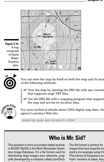
Digital Raster Graphics (DRG) ...42
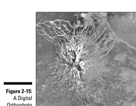
Digital Orthophoto Quadrangle (DOQ) ...44
Satellite data ...44
Part II: All About GPS ...47
Chapter 3: GPS Fundamentals . . . .49
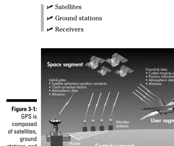
What Is GPS? ...49
How GPS Works ...50
Eyeing satellites ...51
GPS radio signals ...52
Covering ground stations ...53
GPS receivers ...53
How accurate is a GPS receiver? ...56
Information from GPS Receivers ...58
GPS Receiver Features ...59
Display and output ...59
Alarms ...60
Built-in maps ...60
Electronic compass ...62
Altimeter ...62
Increasing accuracy ...63
WAAS ...63
Differential GPS ...64
Antennas ...64
Internal memory ...66
External storage ...66
Accessory programs ...66
User interface modes ...66
Synthesized voice ...67
Chapter 4: Grasping Important GPS Concepts . . . .69
Linking GPS, Maps, and Coordinate Systems ...69
Understanding GPS and Datums ...72
Setting Waypoints ...73
Saving waypoints ...74
Using the waypoint list ...75
Following Routes ...77
Making Tracks ...79
Chapter 5: Selecting and Getting Started with a GPS Receiver . . . .83
Selecting a GPS Receiver ...84
To map or not to map ...86
Road warriors ...87
Matching GPS receiver features to your activities ...88
Becoming Familiar with Your New GPS Receiver ...90
Powering Your GPS Receiver ...91
Battery basics ...92
Power to the people ...94
Initializing Your GPS Receiver ...95
Changing Receiver Settings ...98
Using Your GPS Receiver ...100
Coming home ...101
How far, how fast? ...101
Finding your ancestors ...102
Simulating navigation ...102
Chapter 6: Using GPS with a PDA . . . .105
Choosing between a GPS Receiver and a PDA ...105
PDA advantages ...106
PDA disadvantages ...106
Interfacing Your PDA to a GPS Receiver ...108
Handheld GPS receivers ...108
Mouse GPS receivers ...109
GPS receiver cards ...110
GPS receiver sleeves ...111
Bluetooth GPS receivers ...112
GPS-integrated PDAs ...113
Reviewing PDA Mapping Software ...113
xiii
Chapter 7: Geocaching . . . .117
Geocaching: The High-Tech Scavenger Hunt ...117
Getting Started Geocaching ...119
What you need to geocache ...119
Selecting a cache to look for ...122
Finding the cache ...125
GeoJargon: Speaking the lingo ...132
Hiding a Cache ...133
Selecting a container ...133
Location is everything ...134
Stocking the cache ...136
Submitting the cache ...137
Maintaining the cache ...139
Geocaching Etiquette ...139
Internet Geocaching Resources ...140
Part III: Digital Mapping on Your Computer ...143
Chapter 8: Digital Mapping Hardware Considerations . . . .145
Digital Mapping Software Choices ...145
Processing Power ...146
Processors ...147
Memory ...147
Storage Capacity ...147
Hard drives ...148
CD and DVD drives ...149
Display Equipment ...150
Graphics cards ...150
Monitors ...150
Printers ...150
Communication Capabilities ...151
Communication ports ...151
Internet connection ...152
Chapter 9: Interfacing a GPS Receiver to a Computer . . . .153
About (Inter)Face: Connectivity Rules ...153
Anatomy of a Link: Understanding the Interface Process ...154
xv
Table of Contents
Understanding Ports and Protocols ...156
COM ports ...157
USB ports ...159
Protocols ...160
Managing Memory ...160
Transferring GPS Data ...162
Troubleshooting Connection Problems ...165
Uploading Firmware Revisions to Your GPS Receiver ...166
Chapter 10: Using GPS Manufacturer Mapping Software . . . .169
Understanding Universal Principles of GPS Map Software ...170
Three rules of GPS mapping software ...170
Common GPS map software features ...171
Getting maps to GPS receivers ...172
Reviewing GPS Manufacturer Software ...173
Magellan MapSend ...174
Lowrance MapCreate ...176
Garmin MapSource ...178
Chapter 11: Finding Places and Coordinates . . . .181
Finding Your Way with Online Gazetteers ...181
Using the Geographic Names Information System (GNIS) ...182
Using the GEOnet Name Server (GNS) ...186
Converting Coordinates ...189
Using GeoTrans ...189
Using online conversion utilities ...191
Chapter 12: On the Road with DeLorme Street Atlas USA . . . .193
Discovering Street Atlas USA Features ...194
Navigating Street Atlas USA ...194
Exploring the Street Atlas USA interface ...195
Zooming in and out ...196
Moving around in Street Atlas USA ...197
Getting POI information ...198
Finding an Address with Street Atlas USA ...199
Getting from Here to There with Street Atlas USA ...201
Creating a route ...202
Getting directions ...202
Printing and saving directions ...203
Other Street Navigation Software ...207
Microsoft Streets & Trips ...208
Rand McNally StreetFinder & TripMaker Deluxe ...208
Chapter 13: On the Ground with Maptech Terrain Navigator . . . .209
Discovering Terrain Navigator ...210
Displaying Maps and Finding Places ...210
Navigating a Terrain Navigator Map ...213
Moving around in a map ...214
Changing the map size ...214
Planning a Trip with Terrain Navigator ...215
Understanding Terrain Elevation ...217
Using a 3-D map image ...218
Charting elevation profiles ...220
Reviewing Other Topographic Map Software ...221
DeLorme mapping products ...221
National Geographic mapping products ...223
Chapter 14: From the Air with USAPhotoMaps . . . .227
Enhancing TerraServer-USA with USAPhotoMaps ...227
Discovering USAPhotoMaps Features ...228
Downloading Aerial Photographs ...228
Getting the Most from Aerial Photos ...231
Switching between aerial photos and topographic maps ...231
Moving around the map ...233
Zooming in and out ...234
Enhancing contrast ...234
Entering text ...235
Creating and Using Multiple Map Files ...236
Saving Aerial Photos ...237
Interfacing with a GPS receiver ...238
Reviewing Other Aerial Photo Software ...239
TerraClient ...239
TopoFusion ...241
ExpertGPS ...241
QuakeMap ...243
Chapter 15: Creating and Using Digital Maps with OziExplorer . . .245
Discovering OziExplorer Features ...245
Moving from Paper to Digital Maps ...248
Step 1: Scan the map ...249
xvii
Table of Contents
Step 3: Calibrate the map ...251
Checking your work ...257
Chapter 16: Going Three Dimensional with 3DEM . . . .259
Comparing 2-D and 3-D Maps ...259
Discovering 3DEM Capabilities ...260
Using DEM Data to Create a Map ...260
Creating a 3-D Map ...263
Defining the display area ...263
Creating a 3-D scene ...264
Manipulating the 3-D Scene Window ...266
Saving and Printing a 3DEM Scene ...267
Overlaying Digital Raster Graphics Data ...268
Downloading a sample DRG ...268
Loading the DRG as an overlay ...269
Working with overlay maps ...271
Reviewing Other 3DEM Features ...272
Other 3-D Mapping Software ...272
Global Mapper ...272
MICRODEM ...274
Bundled map programs ...274
Part IV: Using Web-hosted Mapping Services ...275
Chapter 17: Saving and Editing Street Maps . . . .277
Saving Maps ...278
Save Picture As ...278
Using the Print Screen key ...279
Using screen capture programs ...279
Editing a Map ...281
Opening a file ...281
Cropping ...281
Using colors and fonts ...282
Adding symbols ...283
Selecting the right file format ...286
Chapter 18: Navigating Web Road Maps . . . .289
Using Street Map Web Sites ...289
Listing common street map Web site features ...290
Reviewing Street Map Web Sites ...293
MapQuest ...295
Rand McNally ...296
Maporama ...298
Chapter 19: Exploring Web Topographic Maps . . . .301
Using Web-hosted Topographic Maps ...301
Advantages of topographic Web sites ...301
Disadvantages of topographic Web sites ...302
Deciding between Web-based maps and mapping programs ...302
Reviewing Topographic Map Web Sites ...303
Using Maptech MapServer ...303
Using GPS Visualizer ...308
TerraSever-USA ...310
Commercial topographic Web map sites ...311
Chapter 20: Overhead Image Web Sites . . . .315
Using Web Aerial and Satellite Images ...315
Reviewing Aerial and Satellite Image Web Sites ...317
TerraServer-USA ...318
TerraServer.com ...323
GlobeXplorer ...326
Part V: The Part of Tens ...331
Chapter 21: Ten Great GPS and Map Web Sites . . . .333
Comprehensive GPS Information ...333
Current GPS News and Helpful Advice ...334
Technical GPS Information ...334
Free Maps ...334
Expert Desktop Mapping Guidance ...335
Definitive Terrain Modeling Information ...336
Chapter 22: Ten Map Printing Tips . . . .337
Make Your Paper Count ...337
Print in Color ...338
Print the Scale ...338
Print UTM Grids ...338
Waterproof Your Plain Paper ...339
Print More Map Area ...340
Put North at the Top ...340
Use the Best Page Orientation ...340
Beware of False Economy ...341
Chapter 23: Ten Tips for Athletes . . . .343
General GPS Tips for Athletes ...343
Using a GPS receiver for training ...343
GPS receiver limitations for training ...345
How to carry your GPS receiver on foot ...346
GPS Products for Athletes ...348
Endless Pursuit ...348
Timex Speed + Distance/Bodylink ...350
Garmin Forerunner 201 ...351
GPS Tips for Specific Sports ...352
GPS for cyclists ...352
GPS for golfers ...353
GPS for paddlers and rowers ...354
GPS for race directors ...355
Index...357
xix
Introduction
A
s you may have guessed from the title, this book is about GPS (the satellite-based Global Positioning System) and maps; digital maps to be exact.I remember back in 1989 when Magellan introduced the first handheld GPS receiver, the NAV 1000. (Don’t worry. This isn’t going to be one of those “I used to walk 20 miles to school in the snow when I was your age,” stories.) The NAV 1000 was the size of a brick, and weighed a little less than two pounds. It was single channel receiver, could only track four satellites, and just supported latitude and longitude coordinates. It could save 100 way-points and you could have a single route with up to 10 wayway-points. It cost $2,500.
Fast forward to the present. Now I can go down to my neighborhood sporting goods store and buy a GPS receiver smaller than a small cell phone. It weighs a couple of ounces, can track up to 12 satellites, and on a good day tells me exactly where I’m located to within about 10 feet; and in several different coordinate systems by the way. It supports 500 waypoints and 20 routes, with 125 waypoints apiece. Best of all it costs around $100.
Maps have followed the same evolutionary path. Paper maps have turned digital and now you can visit a Web site and print out a map with driving directions to just about anywhere for free. For under $100 you can buy map-ping software that has a collection of CD-ROMs with detailed topographic maps that fully cover any state in the United States. Aerial photographs are readily available over the Internet, and stunning three-dimensional maps can be created with a few mouse clicks. Once the exclusive domain of profes-sional cartographers and GIS (Geographic Information System) specialists, the average computer user can create and use digital maps with relative ease. There are a number of free and inexpensive programs that make desktop mappinga reality for the rest of us.
Over the past several years, GPS receivers have become extremely popular and affordable. Lots of people who venture away from urban areas are carry-ing them. Cars come installed with GPS navigation systems for negotiatcarry-ing city streets and highways. Cell phones are even starting to show up with tiny GPS receivers embedded inside. And even if you don’t have a GPS receiver you can always go out on the Web and print a map of where you want to go. But, there are a few hitches in this perfect, always found world:
GPS receivers tend to boast so many features it’s easy to get lost trying to figure them all out. Plus, most GPS receiver owners typically only use a small subset of the available features (and sometimes don’t even know how to use these features well enough to avoid getting lost).
GPS receivers have capabilities and limitations that many owners (or potential owners) really don’t understand. This leads to frustration or not being able to use the devices to their full potential.
While many people have a general knowledge of how to read a map, at least the simple road variety, most don’t know how to really maximize using a map.
And finally, the average computer user isn’t aware of the wealth of easy-to-use, free or inexpensive mapping resources he or she could be using to stay found.
The purpose of this book is to help you better understand and use GPS receivers and open your eyes to the world of digital mapping. And hopefully put you on the path of always staying found or finding what you’re looking for.
Who This Book Is For
If you’re browsing through this book at your favorite bookstore right now, and are wondering whether this book is for you, ask yourself these questions:
Are you considering purchasing a GPS receiver?
Have you recently purchased a GPS receiver?
Have you owned a GPS receiver for a while, but want to get more out of it?
Are you interested in using digital maps for your profession or hobby?
Getting a bit more specific, people in the following groups should find this book especially useful:
Recreation– Hikers, hunters, fishers, mountain bikers, trail runners, cross country skiers, snowshoers, snowmobilers, ATV and 4 x 4 drivers, prospectors, pilots, paddlers, geocachers, and anyone else who ven-tures outdoors away from cities and streets (with or without a GPS receiver).
Commercial– Land developers and real estate agents who are interested in the competitive advantage maps can bring them for planning or mar-keting purposes.
Government– Emergency response agencies (search and rescue, fire, law enforcement, disaster relief) and urban planners who use maps as part of their planning and response activities.
Environmental– Conservation agencies, organizations, consultants and scientists (biologists, botanists, and other ists) who use maps for resource management and research.
Technology– Anyone who likes to play with cool technology.
You may have noticed I didn’t mention people like surveyors or GIS profes-sionals. If your job primarily focuses on GPS and/or maps, you’ll probably discover a few things in the following pages, but just remember that this book is for the average computer user and GPS receiver owner who doesn’t have your level of technical experience, proficiency, and skills. Please don’t expect to find the nuts and bolts and details of using GIS software or preci-sion surveying electronics.
Setting Some GPS Expectations
Before getting started, I’d like to set a few expectations about the content you’ll be reading about that relates to GPS receivers, just so we’re all on the same page:
This book focuses on handheld, consumer GPS receivers typically used for land navigation. In addition to these types of GPS receivers there are larger and less portable consumer and commercial models that are used in airplanes, boats, and vehicles. There are also restricted-use GPS units used by the U.S. government and military, and expensive receivers used for surveying. While some of these GPS receivers are discussed briefly, don’t expect to find out as much about them as about the portable, con-sumer models.
3
While most GPS receivers have the same functionality, there are a lot of differences in manufacturer and model user interfaces. In a way it’s like sitting someone down in front of three personal computers, one running Microsoft Windows XP, one running Linux (with the KDE or Gnome inter-face), and the other a Macintosh, and asking a computer novice volun-teer to perform an identical set of tasks on each of the computers. Good luck! Because of this, you’re not going to find detailed instructions on how to use specific GPS receiver models. What you will find is informa-tion on how to use most any GPS receiver, with some kindly suggesinforma-tions tossed in when it’s appropriate to consult your user’s guide for details.
Finally, don’t expect me to tell you what’s the best GPS receiver. Like any consumer electronics product, GPS receiver models are constantly changing and being updated. Instead of recommending that you buy a certain brand or model (that could possibly be replaced by something cheaper and better over the course of a few months), I’ll tell you what questions to ask when selecting a GPS receiver and give you some hints on which features are best for different activities. You’ll be able to apply these questions and selection criteria to pretty much any GPS receiver (no matter how much the marketplace changes), to pick the right model for you.
Take comfort in the fact that it’s pretty hard to go wrong when you purchase a GPS receiver from one of the Big Three manufacturers (Garmin, Magellan, and Lowrance). All these companies make excellent products, and you can expect to get a number of years use out of them. (The good news is that GPS technology and product features haven’t changed as rapidly as personal com-puters. I can go out and happily use a GPS receiver from 1998, whereas the same vintage personal computer would have been recycled a long time ago.)
How This Book Is Organized
This book is conveniently divided into several different parts. The content in each part tends to be related, but by all means, feel free to skip around and read about what interests you the most.
Part I: All About Digital Maps
digital maps that are available, especially the free ones you can get from the Internet and about some of the software you can use for digital mapping.
Part II: All About GPS
This is the part of the book devoted to demystifying GPS and GPS receivers. You’ll find out about the technology behind GPS (including its capabilities and limitations), basic GPS concepts such as waypoints, routes, tracks, and coordinate systems, how to select and use a GPS receiver, how to use GPS with PDAs (like Pocket PCs and Palms), and all about the popular GPS sport of geocaching.
Part III: Digital Mapping
on Your Computer
In this part we’ll take some of the theoretical information on digital maps from Part I, and get practical. This section discusses computer requirements needed for basic digital mapping and reviews a number of different software packages you can use to work with aerial photos and topographic and road maps. Many of these programs support uploading and downloading data to and from GPS receivers, so we’ll also spend some time talking about how to interface a GPS receiver to a personal computer.
Part IV: Using Web-Hosted
Mapping Services
Even if you don’t have a GPS receiver or mapping software installed on your computer, with an Internet connection and a Web browser you can still do a remarkable amount of digital mapping with free and subscription Web ser-vices. This section discusses how to access and use online street maps, topo-graphic maps, aerial photos, and some slick U.S. government-produced maps. You’ll also discover how to save and edit these Web-based maps.
Part V: The Part of Tens
All Dummies books have a part called The Part of Tens, and this one is no exception. In this section you’ll find lists of what I consider the best GPS and digital map Web sites on the Internet, where to find free digital maps, tips and
5
hints on printing maps, and if you’re a competitive or recreational athlete, how to use a GPS receiver in your outdoor workouts.
Icons Used in This Book
Maps use symbols to quickly convey information, and this book does the same by using icons to help you navigate your way around. They include:
Just a gentle little reminder about something of importance, and because I can’t be there to mention it in person and give you a friendly but stern look while wagging my finger, this icon will have to do.
I’ve tried to keep the real geeky, nerdy things to a bare minimum, but because this is a book about cool electronic gadgets and computer mapping, some-times the technical stuff does creep in. I’ll either give you a plain-English explanation or point you off to a Web site where you can get additional details.
This is good stuff designed to make your life easier; usually gained from practical experience and typically never found in manufacturer user guides and product documentation; or if it is there, it’s buried in some obscure paragraph.
The little bomb icon looks like it should signify some pretty bad juju, but in reality it could represent something as minor as potentially causes a hangnail. The key here is to pay attention, because there might be something lurking that causes mental, physical, emotional, or monetary suffering of some degree. Who would have thought reading GPS and Maps for Dummies could be an extreme sport?
Some Opening Thoughts
Before you jump into the exciting world of GPS and digital maps, and I know you can’t wait, there are a couple final things I’d like to mention:
There are lots of references to Web sites in this book. Unfortunately Web sites change just about as fast as street maps in a city experiencing a lot of growth. If for some reason a link doesn’t work, you should have enough information to find what you’re looking for by using a search engine such as Google.
this book from turning into an encyclopedia. So please don’t get upset if I didn’t mention a program you use or you feel slighted because I ended up talking about one program more than another.
On some occasions while you’re reading this book you’re probably going to think I’m starting to sound like a broken record on one point I feel is very important. If you venture out away from civilization with your GPS receiver, please bring a compass and a paper map with you, and know how to use all of them. That means really knowing how to use them, not just kidding yourself that you do. From many years of doing search and rescue work and finding lost people, I’ve discovered the following truths:
• GPS receiver batteries die at the most inopportune time; especially when you didn’t bring spare batteries with you.
• If a GPS receiver breaks or gets lost, it will be at the worst possible moment.
• GPS receivers are not Star Trekteleporters that will instantly trans-port you out of the wilderness and trouble (this is also true when it comes to cell phones).
All the information in this book should set you on your way to becoming an expert with a GPS receiver and maps. That is, if you go out and prac-tice! If you want to have guru status you need to be out there applying what you discover in this book. Even if you don’t aspire to becoming one with GPS and a master of maps, in order to get the most use out of your navigation tools you need to become both comfortable and confident with them. Discover, experiment, and have fun!
7
Part I
W
hile digital maps are made up of bits and bytes, they share a number of things in common with their paper and ink cousins — like datums, coordinates systems, scales, legends, and compass roses. In fact if you get some of these concepts down, which hopefully you will after reading this part, you’ll be at home with just about any map you encounter, whether it’s displayed on your PC’s monitor or laying on the front seat of your car.Chapter 1
Getting Started with Digital Maps
In This Chapter
Discovering digital maps
Using digital maps
Discovering types of map programs
Understanding the differences between Geographic Information System (GIS) and consumer mapping programs
T
his chapter introduces you to the fundamentals of digital maps. You find out what a digital map is, the differences between static and smart digital maps, and the different types of programs available for using digital maps.What Is a Digital Map?
Any mapis a picture of where things are, generally associated with our planet and its geographic or man-made features. Road maps, hiking maps, maps to Hollywood stars, and all sorts of other maps provide a sense of place and often help you get from one place to another.
Most maps are printed on paper. That’s pretty convenient. They can be folded into a lightweight, compact bundle (if you’ve had a little practice). Digital maps
(maps made on a computer or meant to be used with a computer) serve the same purpose as their paper cousins. It’s just more difficult to fold a CD.
Digital mapmaking is a significant leap forward from traditional paper maps.
Maps can be made faster, cheaper, and more accurately.
This is important because of how quickly new roads, subdivisions, and development projects pop up in fast-growing urban areas. An old street map isn’t much help in a new subdivision with a couple of hundred homes. The same problem affects political maps; an example is the change in national names and borders after the end of the Soviet Union.
Read on to discover the many types of digital maps.
Static map
A static mapis the simplest form of digital map. Often it’s a paper map that’s been scanned and turned into a BMP (bitmap) or JPG (graphic) file. Aside from displaying it, printing it, and perhaps making a few edits, what you can do with the map is limited.
Static maps used to be the only type; often, a static map is all you need.
Smart map
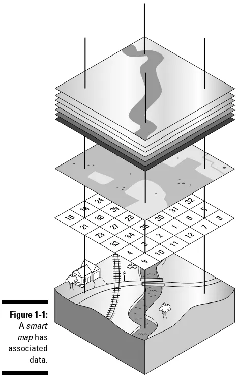
Smartdigital maps (as shown in Figure 1-1) may look like static maps, but data is associated with map locations. The data can be as basic as the lati-tude and longilati-tude of a point, or as detailed about vegetation, soil type, and slope.
Spatialor geospatialdata is associated with a place. The place can be smaller than a meter or as large as a country. Spatial data can be stored two ways:
Embedded in a map graphic file
Separate files with references to the locations
TIFF(Tagged Image File Format) is a popular format for storing graphics files. The GeoTIFFextension embeds geographic tags into map images. If you view a GeoTIFF file with a standard graphics program, it looks like an ordinary map. A program that uses the data tags can access the spatial data associated with each pixel in the image.
Making maps
Cartographyis the art and science of making maps. Until the 1960s, maps were made the time-honored, traditional way:
1. Draw an original map by hand, based on land survey measurements and other information.
2. Print as many copies as you need.
are easier to use (and much less expensive) than their professional counter-parts, meeting most computer users’ mapping needs.
This book focuses on mapping programs available to consumers.
GIS (Geographic Information System)
A Geographic Information System(GIS) is an information system that analyzes, inputs, manipulates, outputs, retrieves, and stores spatial data. GIS is mostly used by governments; large corporations; and engineering and GIS consulting firms for land, natural resources, transportation, environmental, and urban planning and management.
Some people use the terms digital mapand GISinterchangeably. This really isn’t correct. GIS isn’t just about making maps. GIS involves using computers and special software to help people make decisions by using spatial data.
Distinguishing between consumer mapping programs and GIS programs is important:
GIS software,which is sold primarily to governments, corporations, and consulting firms, is flexible, powerful, and relatively expensive.
Consumer mapping programstarget the needs of average computer users. These programs are much more limited in scope and functionality — and a lot less expensive — than GIS programs.
GIS software typically has a steep learning curve; you can earn advanced degrees in GIS. Consumer mapping programs can mostly be used right out of the box and can be mastered in a relatively short period of time.
A typical consumer mapping program is a road map program that costs about $30 and provides exact routing directions to get from one location to another. This isn’t a static map because it has underlying data (such as street names, distances, and gas stations), which can lead you to think it’s a GIS program. Not so. A true GIS program has built-in precision tools that can (for example) let you input data about traffic flow and vehicle speeds, and then display every street where traffic volume exceeds 500 cars per hour and vehicle speeds are .5 miles an hour over the speed limit. The price tag for such a GIS program would be at least $1,000, not to mention the costs of training people to use it and gathering all the traffic data to input into the system.
Using Digital Maps
There’s an old song that goes, “Anything you can do, I can do better.” If digital maps could sing that tune to their paper counterparts, they’d be right (for the most part). Digital mapping software offers all sorts of enhancements over paper maps, including these capabilities:
Finding street addresses quickly
Interfacing with GPS receivers to see where you are or where you were
Showing driving directions to just about anywhere
Displaying terrain three-dimensionally
Annotating maps with pop-up information
Creating custom maps
Printing a hard copy map (which is sometimes the most important)
Digital maps do have a few drawbacks, including these:
You need a computer.
If you have a laptop or personal digital assistant (PDA), you can take mapping software on the road with you.
You need software.
This book helps you select and use software packages, particularly map-ping programs in the free–$100 price range.
You have to spend time mastering the software.
Most mapping software is readily usable, but all programs have nuances that sometimes make their features and user interfaces a little tricky.
Mapping Software: The Essentials
The first step for digital mapping is to understand the available types of map-ping programs and their capabilities and limitations; that’s what this part of the book is all about.
After you know what software is available, you can match it to your needs. An invitation to a birthday party may consist only of displaying a screen capture of a street map on a Web site, editing and saving the map in Paint, and then e-mailing it to friends. A week-long backpacking expedition would require a
topographic mapping program (showing land features) to plan your route, view elevation profiles, and upload location data to your GPS receiver.
15
Before you can select the right tool for the right job, you need a general handle on the options that you can include in your digital-mapping tool chest. This section of the book organizes mapping programs into three categories:
Standalone programs
Programs bundled with maps
Web-hosted mapping services
Standalone programs
A standalone programis a program that can open and use digital maps. These programs typically don’t come with map data, and you’ll need to download or purchase the maps you’re interested in using.
Like with a word processor or a spreadsheet, a mapping program needs some-one to input data before it can be useful. In this case, the data is bits and bytes that describe how a map should be displayed. Fortunately, an amazing amount of map data is freely available on the Internet, most of it already col-lected by the government and in the public domain.
A big market exists for commercial map data. People buy data to use with their mapping programs because
Free data may not be available for an area or a specific need.
Commercial data may be enhanced with information unavailable in the free versions.
Firing up a CD filled with data is more convenient than searching for free data and then downloading it.
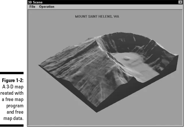
Many standalone mapping programs aren’t tied to one data type. (Chapter 2 shows which types of digital map data are commonly used.) Figure 1-2 shows a three-dimensional map of Mount St. Helens created with 3DEM from free U.S. Geological Survey (USGS) digital elevation map (DEM) data. (Mount St. Helens, an active volcano in Washington State, erupted in 1980.) The elevation map shows the crater and how the volcano blew out its side.
Map programs are viewers, editors, or both:
Viewersshow only maps.
Editorscan make changes.
Many standalone programs are either free or shareware. Two aspects of such programs are especially worth noting:
Some manufacturers offer free (or cheap) limited-feature versions of their products that are otherwise available as pricy commercial software.
Standalone mapping programs are mostly suited to a user who has inter-mediate to advanced computer skills and experience.
Examples of standalone mapping programs include OziExplorer (www. oziexplorer.com), USAPhotoMaps (http://jdmcox.com), and 3DEM (www.visualizationsoftware.com/3dem.html). Don’t forget that you can also make maps with Paint or any other general-purpose graphics pro-gram. This book shows how to use these programs and others.
Some free, noncommercial mapping programs have advanced features that are normally more suited to professional users. Don’t be intimidated by every feature and option. You can use some commands and features to make maps for your needs. And you can master those other features if you ever need to.
One big disadvantage to standalone mapping programs is that you need to search the Internet for the data you need, find and download it, and then open it with the map program. This process sometimes involves registeringa map so that the coordinates all line up. Also, even with a high-speed Internet connection, downloading can still be a hassle. And after all that, you still have to find the map data for an area that you want to view, and then successfully load all that stuff into the mapping program.
Figure 1-2:
A 3-D map created with a free map program and free map data.
17
Programs with bundled maps
Mapping companies bundle software with digital maps. The program comes with the map data and is distributed on CDs or DVDs; static or smart maps that have a lot of detail can be quite large in size. You install the mapping program, and you’re immediately ready to start using the data on the CD.
Data files bundled with software are often in a proprietary file format, which can be read and used only with the software that comes with the product. The same usually holds true for maps that you can upload to a GPS receiver; only maps from the manufacturer can be used.
Sometimes you don’t have much choice between using a standalone program or one bundled with maps.
Topographic map data of the United States is widely available for free. You can use a number of free or shareware programs to view maps.
Only outdated Census Bureau map data is available for United States streets and roads. Most free or shareware programs don’t match the features in commercial products.
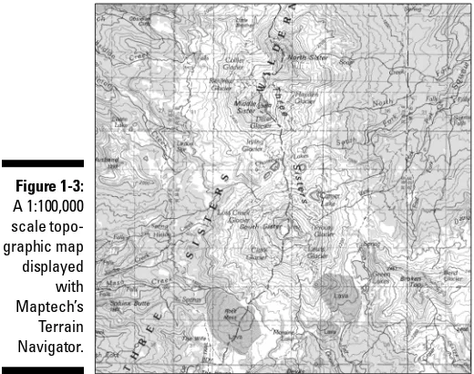
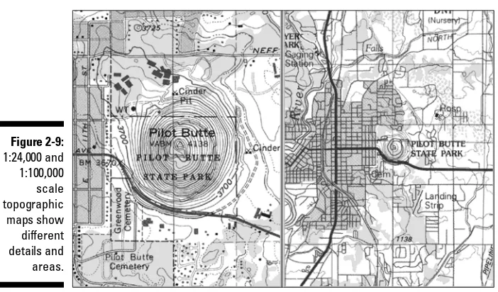
Software that comes with bundled maps has gotten incredibly cheap over the years. With discounts and rebates, you can often find road atlas software for around $20 that covers the entire United States. For a little under $100, you can buy programs that come with a full set of detailed digital topographic maps for an entire state. Considering that a single paper USGS 1:24,000 map costs around $7 — and there can easily be over a thousand maps per state — that’s a pretty decent value. Figure 1-3 shows a map made by Terrain Navigator (www.maptech.com/land/TerrainNavigator), which is a topographic map-ping program that comes bundled with map data.
Manufacturers that sell bundled map programs (particularly those with street and road data) usually come out with a new release of their product every year or so. In addition to enhancements in the software, the map data contains new roads and updated services information (such as gas stations, restaurants, and hotels, called POIs, or Points of Interest). Whether you buy an updated copy of the software every year depends on your circumstances. If you usually travel on major roads, or in areas that haven’t experienced much development and growth, you probably don’t need to update every year. On the other hand, road atlas software is fairly inexpensive, so if you travel a lot and rely on the program, it can be a cheap investment.
If you have beginning to intermediate computer skills and experience, you can come up to speed quickly with bundled map programs. The user interfaces are generally simpler than those found in feature-rich, standalone programs.
maps.nationalgeographic.com/topo), and mapping software from GPS manufacturers that interfaces with their receivers. These programs and others like them are discussed in following chapters.
Web-hosted mapping services
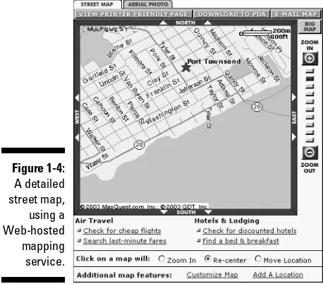
A Web-hosted mapping serviceis a Web site that displays a map. You just need Internet access and a browser to view street maps, topographic maps, aerial maps, satellite imagery, and many other types of maps. This eliminates pur-chasing and installing specialized programs and map data on your hard drive, swapping CDs to access new map data, and mastering a new program. (Figure 1-4 is a detailed street map of downtown Port Townsend, Washington, using
www.mapquest.com, a Web-hosted mapping service.)
If a map isn’t displayed, check your browser’s Java settings first. A number of Web-hosted mapping services, in particular the U.S. government sites that all share the same mapping engine, require Java and/or JavaScript enabled in your browser before maps can be correctly displayed.
Most Web-hosted mapping services are extremely easy to use. Anyone who can use an Internet browser should be navigating through maps in no time.
Examples of Web-hosted mapping services include MapQuest (www.mapquest. com), TerraServer-USA (http://terraserver-usa.com), and TopoZone (www.topozone.com). You discover how to use these mapping Web sites and others in other chapters of this book.
Figure 1-3:
A 1:100,000 scale topo-graphic map displayed with Maptech’s Terrain Navigator.
19
Although most of these free Web sites don’t have all the features of a map program that you install on your hard drive, they offer a surprising amount of capability, especially considering their cost. (Some mapping sites on the Web charge for advanced services, such as color aerial photographs, larger map sizes, and enhanced searching.)
Figure 1-4:
A detailed street map, using a Web-hosted mapping service.
A few words on commercial GIS software
This book doesn’t dwell overmuch on commercialGIS software packages. If your mapping needs get complex enough to require GIS (or you just want to find out more about these high-end mapping systems), check out the Web sites of the top three GIS companies:
ESRI: Environmental Systems Research Institute is the largest GIS company in the marketplace. Its Arc products (such as ArcInfo and ArcView) are standards in the GIS field. For more information about ESRI, go to www.esri.com.
MapInfo:MapInfo develops and sells a wide array of GIS products. For more information
on the company and its products, see www. mapinfo.com.
Autodesk: Autodesk is the developer of AutoCAD, a widely used computer-aided design program. Autodesk add-ons and standalone GIS programs are used through-out the world. You can find through-out abthrough-out the Autodesk mapping applications at www. autodesk.com.
Chapter 2
Dissecting Maps
In This Chapter
Discovering maps
Understanding map projections
Delving into datums
Getting a handle on coordinate systems
Differentiating digital map data types
M
aps are everywhere. They tell us how to get places we want to go and give us a better understanding of our surroundings.Some people think that they can pick up a map and immediately start using it. If you don’t have a lot of experience using different types of maps, that’s a little like thinking just because you can read, you can sit down and understand a book that’s written in French, German, or Spanish even if you’ve never had a foreign language class in your life. Yes, you may make a little sense of the book by picking out a few words you recognize or by looking at the pictures, but in the process, you’re missing out on some important information.
Discovering the Types of Maps
Maps have their own language and a number of dialects depending on the type of map. To use paper or digital maps effectively, you need at least a tourist’s understanding of their language. The more you know, the better off you are.
Topographic maps
Topographic mapsshow natural land features such as lakes, rivers, and moun-tain peaks as well as man-made features such as roads, railroad tracks, and canals. These maps also have contour lines that trace the outline of the terrain and show elevation. Contour linessuggest what the land looks like in three dimensions.
A contour intervalis the distance between contour lines. For example, if a contour interval is 20 feet, every time you go up one contour line, the eleva-tion increases by 20 feet. Conversely, every time you go down a contour line, the elevation decreases by 20 feet. When the contour lines are close together, the terrain is steep. When they’re spread apart, the terrain is closer to flat. Different maps have different contour intervals and the distance is usually noted in the map legend.
The most popular topographic maps for use within the U.S. are made by the United States Geological Survey (USGS). These maps cover different sizes of area; the smaller the area, the greater the detail. Topographic maps are often called topo maps.The topo maps that show the most detail are sometimes called quad sheetsor 7.5 minute mapsbecause they map just one quadrangle
(geographer-speak for rectangular shaped piece of land) that covers 7.5 min-utes of longitude and latitude. Figure 2-1, for example, is a topographic map of The Dalles, Oregon.
A compass uses degrees to tell direction. North is 0 or 360 degrees, west is 90 degrees, south is 180 degrees, and east is 270 degrees.
Figure 2-1:
A topo-graphic map showing contour lines and other features.
23
Most topographic maps show magnetic declination.Compass needles point to magnetic north, but most maps are oriented to true north. Because the earth’s magnetic field varies from place to place, magnetic north usually isn’t the same as true north; in the continental United States, the difference can be as much as 20 degrees. If you don’t account for the magnetic declination, you can get far off-course trying to navigate someplace with a compass. The declination
tells you how many degrees you need to adjust your compass: If the declina-tion is west, you subtract the degrees from 360 to get true north; if it’s east, you add the degrees.
Magnetic declination changes over time, and older USGS maps can have incor-rect declination information printed on them. Using the wrong declination can cause all sorts of navigation problems, so check the current declination for your area at the following Web site: www.ngdc.noaa.gov/cgi-bin/seg/ gmag/declination1.pl.
If your job or hobby takes you off the beaten path, you definitely need a topo-graphic map. If you’re staying in your car, driving on paved roads, you proba-bly don’t need a topographic map.
Planimetric maps
Planimetric maps don’t provide much information about the terrain. Lakes, rivers, and mountain pass elevations may be shown, but there isn’t any detailed land information. A classic example of a planimetric map is a state highway map or a road atlas. Planimetric maps are perfect in cities or on high-ways, but they’re not suited for backcountry use. Figure 2-2 is a planimetric map of The Dalles, Oregon, area.
Figure 2-2:
When using planimetric maps, you’ll often encounter these terms:
Atlas:An atlas is a collection of maps, usually in a book.
Gazetteer:A gazetteeris a geographical dictionary or a book that gives the names and descriptions of places.
Marine
Marine chartsare maps for inland, coastal, and deep-water navigation. Charts from the National Oceanic and Atmospheric Administration (NOAA) are com-monly used for boating. They provide such important information as water depth, buoy locations, channel markers, and shipping lanes. See www.noaa. gov/charts.htmlfor more on NOAA charts.
Marine charts aren’t available for all bodies of water. If you’re boating on a lake or a river, you’ll probably use a topographic map for navigation.
This book focuses on land maps, so there isn’t much detail about marine charts. Part of a marine chart of San Francisco Bay, California, is shown in Figure 2-3.
If you’re more of a sailor than a landlubber, check out Marine Navigator at
www.maptech.com. This commercial marine-navigation program displays NOAA charts, aerial photographs, 3-D ocean-bottom contours, and tide and current tables.
Figure 2-3:
A NOAA nautical chart, showing important features for mariners.
25
Aeronautical
Maps designed for aviation use are charts (a term that can also refer to their marine counterparts).These maps provide pilots with navigation information including topographic features, major roads, railroads, cities, airports, visual and radio aids to navigation, and other flight-related data.
You can find such aeronautical chart types as
VFR (Visual Flight Rules)
IFR (Instrument Flight Rules) Enroute
Terminal Area Charts
You can find more about aeronautical charts by visiting the Federal Aviation Administration (FAA) National Aeronautical Charting Office (NACO) at www. naco.faa.gov.
Figure 2-4 shows a pilot’s-eye view of the Seattle area.
FAA aviation charts aren’t freely available for download. The FAA offers a monthly service that provides all charts and updates on DVDs for a year, but the cost is over $300. A number of companies such as Jeppesen (www.jeppesen.com) and Maptech (www.maptech.com) make commercial flight-planning software packages that include digital charts, or you can try the www.aeroplanner.com, a Web service that provides digital charts and other services to pilots. Another noncommercial source of FAA sectional charts is http://aviationtoolbox.org/raw_data/FAA_sectionals.
Figure 2-4:
Figuring Out Map Projections
Making a map is quite a bit more challenging than you may think. A cartogra-pher’s first challenge is taking something that’s round like the earth (techni-cally it’s an ellipsoid that bulges in the middle and is flat at the top and bottom) and transforming it into something that’s flat, like a map.
Cartographers use a projectionto reproduce all or part of a round body on a flat sheet. This is impossible without some distortion, so a cartographer decides which characteristic (area, direction, distance, scale, or shape) is shown accurately and which will be distorted.
Although my high-school geography teacher may smack me on the head with a globe for saying this, the average map user doesn’t need to know what kind of projection was used to make a map. There are some exceptions if you’re a cartographer or surveyor, but usually you won’t get in trouble if you don’t know the projection. So don’t panic if you can’t immediately tell a Lambert conformal from a Mercator or Miller projection. Just keep in mind what a pro-jection is and that there are different types of map propro-jections.
Map Datums
A map datumis a mathematical model that describes the shape of an ellipsoid — in this case, the earth. Because the shape of the earth isn’t uni-form, over 100 datums for different parts of the earth are based on different measurements.
Some serious math is involved here for getting into the nuts and bolts of map datums. If you’re the scholarly type, these Web sites provide lots of details on projections and datums:
Datums and Projections: A Brief Guide
http://biology.usgs.gov/geotech/documents/datum.html
Peter Dana’s excellent Geographer’s Craft site
www.colorado.edu/geography/gcraft/notes/notes.html
Datums all have names, but they aren’t stuffy sounding. Datums often have exotic, Indiana Jones-style names such as the Kerguelen Island, Djakarta, Hu-Tzu-Shan, or Qornoq datums. (The United States uses such boring datums as NAD 27 and WGS 84.)
27
You only need to be concerned with datums under a few circumstances, such as these:
A location is plotted on two different maps.
A map and a Global Positioning System (GPS) receiver are being used.
Two different GPS receivers are being used.
In these instances, all the maps and GPS receivers must use the same datum. If the datums are different, the location ends up in two different physical places even though the map coordinates are exactly the same.
This is a common mistake: GPS receivers use the WGS 84 datum by default, and USGS topographic maps use the NAD 27 datum. If you mix the datums, your location can be off by up to 200 meters (roughly 200 yards, if you’re met-rically challenged).
Utilities can convert coordinates from one datum to another (some are described in Chapter 11) but it’s easier just to get all the datums on the same map.
Working with Map Coordinate Systems
A coordinate systemis a way to locate places on a map, usually some type of grid laid over the map. Grid systems are a whole lot easier to use and more accurate than “take the old dirt road by the oak tree for two miles, then turn left at the rusted tractor, and you’ll be there when the road stops getting bumpy.”
A simple coordinate system can consist of a vertical row of letters (A, B, C) on the left side of the map and a horizontal row of numbers (1, 2, 3) at the bottom of the map. If you want to tell someone where the town of Biggs Junction is (for example), you put your finger on the city and then move it in a straight line to the left until you hit the row of letters. Then put your finger on the city again, but this time move down until you reach the row of num-bers. You now can say confidently that Biggs Junction is located at A12.
I call this the Battleship Grid Systembecause it reminds me of the game where you call out coordinates to find your opponent’s hidden aircraft carriers, sub-marines, and destroyers. “B-3. You sank my battleship!”
comfortable using. For example, USGS topographic maps have latitude and longitude, Universal Transverse Mercator (UTM), and township and range marks.
Most coordinate systems are based on x and y; where xis a horizontal value, and yis a vertical value. A location’s coordinates are expressed by drawing a straight line down to x and across to y. Mathematician René Descartes devised this system in the 1600s.
Letter-and-number coordinate systems are fine for highway maps, road atlases, and other simple maps where precise locations aren’t needed. However, if you want to focus on a precise location on a map, you need a more sophisticated grid system. That’s where coordinate systems such as latitude and longitude and UTM come in.
When you’re figuring out a location’s coordinates on a paper map, you have a fair amount of work to do, aligning the location with primary tick marks and then adding and subtracting to get the exact coordinate. With digital maps on a computer, that’s usually just a matter of moving the cursor over a location and watching with relief as the coordinates automatically appear. If you’re using a paper map, you can make life easier with free overlay grids and rulers from www.maptools.com. With these, you can print grids and rulers for dif-ferent coordinate systems on clear transparency sheets.
Latitude/longitude
Latitude and longitudeis the oldest map-coordinate system for plotting loca-tions on the earth. The Roman scholar Ptolemy devised it almost 2,000 years ago. Ptolemy wrote about the difficulties of accurately representing the earth on a flat piece of paper and created latitude and longitude as a way of solving the problem. That’s pretty impressive for a time way before computers and satellites.
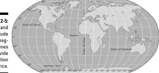
Latitude and longitude are based on a little math, but they’re not really com-plicated. Angles are measured in degrees, and they’re used for measuring cir-cles and spheres. Spheres can be divided into 360 degrees; because the earth is basically a sphere, it can also be measured in degrees. This is the basis of latitude and longitude, which use imaginary degree lines to divide the surface of the earth (see Figure 2-5).
The equatoris an imaginary circle around the earth; the circles are an equal distance from the north and south poles and perpendicular to the earth’s axis of rotation. The equator divides the earth into the Northern Hemisphere
(everything north of the equator) and the Southern Hemisphere (everything south of the equator).
29
Latitude
Latitudeis the angular distance measured north and south of the equator (which represents 0 degrees of latitude).
As you go north from the equator, the north latitudeincreases to 90 degrees when you arrive at the North Pole.
As you go south of the equator, the south latitudeincreases to 90 degrees at the South Pole.
In the Northern Hemisphere, the latitude is always given in degrees north;in the southern hemisphere, it’s given in degrees south.
Longitude
Longitude works the same way as latitude, but the angular distances are mea-sured east and west of the prime meridian (which marks the 0-degrees longitude line that passes through Greenwich, England, without even disturbing traffic).
When you travel east from the prime meridian, the longitude increases to 180 degrees.
As you go west from the prime meridian, longitude also increases to 180 degrees. (The place where the two 180-degree longitudes meet is known as the International Date Line.)
In the Eastern Hemisphere (which is east of the prime meridian to 180 degrees east), the longitude is given in degrees east.
In the Western Hemisphere (which is west of the prime meridian to 180 degrees west), longitude is expressed in degrees west.
One degree is actually a pretty big unit of measure. One degree of latitude or longitude is roughly equal to 70 miles.
Degrees are composed of smaller, fractional amounts that sound like you’re telling time.
Figure 2-5:
That means that Dillon Falls is
41 degrees, 57 minutes, and 29.76 seconds north of the equator
121 degrees, 24 minutes, 34.73 seconds west of the prime meridian
Universal Transverse Mercator (UTM)
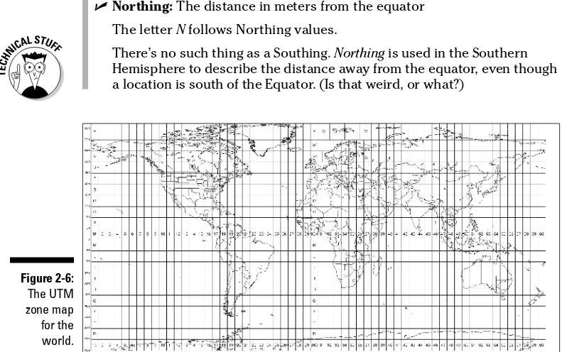
Universal Transverse Mercatoris a modern coordinate system developed in the 1940s. It’s similar to latitude and longitude, but it uses meters instead of degrees, minutes, and seconds. UTM coordinates are very accurate, and the system is pretty easy to use and understand.Although the United States hasn’t moved to the metric system, the system is widely used by GPS receivers. UTM coordinates are much easier than latitude and longitude to plot on maps. The two key values to convert metric measure-ments are
1 meter = 3.28 feet = 1.09 yards.
For ballpark measurements, a meteris a bit over a yard.
1 kilometer = 1,000 meters = 3,280 feet = 1,094 yards = 0.62 miles.
For ballpark measurements, a kilometeris a bit more than half a mile.
Specialized coordinate systems
Here are a few other coordinate systems so youknow what they are:
MGRS (Military Grid Reference System):A coor-dinate system used by the U.S. and NATO military forces. It’s an extension of the UTM system. It further divides the UTM zones into 100-kilometer squares labeled with the letters A–Z.
State Plane Coordinate System:A coordinate system used in the United States. Each state is divided into at least one State Plane zone. Similar to the UTM system, it uses feet instead of meters.
Proprietary grids:Anyone can invent a coordi-nate system for finding locations on a map.
Examples of proprietary systems are ZIP code,
the Maidenhead Locator System(a grid system for amateur radio operators) and Thomas Brothers street guides(that match a location with a page number and grid).
Most coordinate systems try to make navigation and surveying more accurate and simpler.
The UTM system is based on the simple A, B, C/1, 2, 3 coordinate system. The world is divided into zones:
Sixty primary zones run north and south.
Numbers identify the zones that run north and south.
Twenty optional zones run east to west.
These zones indicate whether a coordinate is in the Northern or Southern Hemisphere.
Letters designate the east/west zones.
Often the letter is dropped from a UTM coordinate, and only the zone is used to make things simpler. For example, because most of Florida is in Zone 17 R, if you were plotting locations in that state, you could just use Zone 17 in your UTM coordinates. Figure 2-6 shows its UTM zone map.
To provide a precise location, UTM uses two units:
Easting:The distance in meters to the east from the start of a UTM zone line
The letter Efollows Easting values.
Northing:The distance in meters from the equator The letter Nfollows Northing values.
There’s no such thing as a Southing. Northing is used in the Southern Hemisphere to describe the distance away from the equator, even though a location is south of the Equator. (Is that weird, or what?)
Figure 2-6:
The UTM zone map for the world.
33
Continuing with my example of Dillon Falls, if you use UTM to locate the falls, the coordinates look like this:
10T 0627598E 4868251N
That means that the falls are in Zone 10T, which is 4,868,251 meters north of the equator and 627,598 meters east of where the zone line starts. (For those of you without a calculator in front of you, that’s about 3,025 miles north of the equator, and about 390 miles east of where the number 10 Zone line starts out in the Pacific Ocean.)
Township and Range
The Township and Range coordinate system has been used since the 1790s to survey public lands in the United States. Technically, the official name of this system is the Public Land Rectangular Survey (PLS), but in practical use, most people call it Township and Range.
This coordinate system was developed after the American Revolution as a way to survey and grant title to land that was newly acquired following the country’s independence. Thomas Jefferson helped develop the system, which was enacted under the Northwest Land Ordinance of 1785. Township and Range isn’t used in the eastern United States (or in a few other states) because land surveys in those states had been completed.
The system is based on the following components, which are shown in Figure 2-7:
Meridians and baselines.These lines are the foundation of the Township and Range system:
•Meridiansare imaginary lines that run north to south.
•Baselines are lines that run east to west.
• An initial point is where a meridian and a baseline meet.