Crete Island, Greece, 5–10 June 2016
COMPUTER-AIDED RISK ASSESSMENT AT URBAN SCALE.
MODEL DEFINITION AND VALIDATION ON A CASE STUDY.
A. Basaglia1, A. Aprile1, F. Pilla2 and Enrico Spacone3
1
Department of Engineering, University of Ferrara Via Saragat 1, 44122 Ferrara, Italy
e-mail: {alberto.basaglia,alessandra.aprile}@unife.it 2
Department of Civil, Structural and Environmental Engineering, Trinity College Dublin College Green, Dublin 2, Ireland
e-mail: [email protected] 3
Department of Engineering and Geology, University of Chieti - Pescara Viale Pindaro 42, 65129 Pescara, Italy
e-mail: [email protected]
Keywords: ECCOMAS Congress, Proceedings, Computational Methods, Earthquake Engi-neering, Risk Assessment, Urban Systems.
1 INTRODUCTION
Disaster risk reduction is one of the biggest global challenge, as attested by the U.N. [1]. The first step to achieve disaster resilience enhancement is to propose unified guidelines for disaster management. Among all natural events, earthquakes produce most damage on a vast scale. They cause high number of casualties, severe economic damages and are a major threat for cultural heritage sites. In Europe, historical city centers represent an essential part of the cultural heritage. This immeasurable asset is a “strategic resource for a sustainable Europe” that need to be preserved [2]. Among all European countries, Italy holds the highest number of listed heritage sites as confirmed by UNESCO (whc.ujnesco.org). Seismic risk assessment and urban risk management improvement is the only way to avoid casualties, damages, and consequent settlements abandonment.
2 PROBLEM DEFINITION
Most authors express seismic risk, R, as the relationship between hazard, vulnerability and exposure, as reported in Eq. (1):
(1)
where H is the hazard, i.e. the probability of exceedance of the seismic activity level of inten-sity i, during a specified recurrence period T; V is the vulnerability, i.e. the intrinsic predispo-sition of the e-th exposed element to suffer damage, resulting from a seismic event of intensity i; E is the exposure of all the e-th exposed elements. H and E are directly linked to the site geological properties and the social and economical value of buildings respectively. V, on the contrary can be determined with different methods [3]. Detailed approaches, highly efficient for individual buildings, become ineffective while moving to urban scale analysis. In fact, the use of less sophisticated but more practical methods is required by such complex task.
Currently, one of the main assessment methods used by researchers is the combined ap-proach of the Vulnerability Index method [4, 5, 6] and the Macroseismic method [7, 8]. The first method determines the vulnerability of buildings as a weighted sum of 11 parameters, which represents the main features that influence the buildings’ response to a seismic event. To determine the vulnerability index, a detailed inspection of buildings is required, regarding both geometrical and structural aspects. , have always to fall within the range . The Macroseismic method derives from the definition of the European Macroseismic Scale, EMS-98 [9] and related mean damage grades, , and Damage Probability Matrixes
(DPMs). Buildings are ranged into 6 vulnerability classes with an assigned Vulnerability pa-rameter, , which can be correlated with the parameter of the aforementioned method, us-ing Eq. (2). Then, usus-ing a probabilistic approach, it is possible to determine the damage level the constructions will undergo after an earthquake as well as the number of collapsed or unus-able buildings and the seismic effect on the population.
(2)
This approach presents some main limitations:
a) it considers only masonry constructions;
b) it does not take into account the effects of buildings in aggregate sequence;
c) it considers the overall vulnerability as the simple sum of buildings’ vulnerabilities.
3 MULTIDIRECTIONAL URBAN RELIABILITY ASSESSMENT (MURA-SH) METHOD
In this work, a new methodology is presented as “Multidirectional Urban Reliability As-sessment - Seismic Hazard (MURA-SH)” method [10], based on the improvement of the pre-viously described method.
3.1 Vulnerability index integration for masonry aggregates
A modified approach to the aggregate evaluation proposed by [11] is used: 5 additional pa-rameters (see Tab. 1) are considered together with the 11 ones of the original Vulnerability Index Method [4, 5, 6]. The additional parameters take into account the building’s behaviour when inserted into an aggregate sequence. It is important to remark that contiguity of build-ings can either increase or reduce the seismic vulnerability within the range of 30% of the detached building vulnerability.
Parameters Class Weight
A B C D
P12 Interactions in elevation 0 15 25 45 1.25
P13 Floor plans interactions 0 5 15 45 1.75
P14 Presence of offset ceilings 0 25 35 45 0.75 P15 Structural of typological heterogeneity 0 10 20 45 1.50 P16 Percentage difference within facade openings 0 15 35 45 1.25
Table 1: Vulnerability Index IVadditional parameters for masonry buildings in aggregate sequence
3.2 Proposed – correlation for R.C. buildings
Historical city centers often present an heterogeneous mix of masonry and R.C. construc-tions. In this work, a mathematical correlation between the Vulnerability Index method and the Macroseismic approach for R.C. building is proposed, as reported by Eq. (3).
(3)
The proposed correlation is determined following the same analytical steps described in [3] but, unlike the linear correlation used for masonry buildings, a quadratic correlation is adopt-ed for R.C. constructions.
3.3 Vulnerability ellipses for directional risk assessment
Buildings have usually a non regular plant shape and present different structural properties in each direction. Vulnerability is considered as the sum of isotropic and anisotropic factors [12]. The isotropic factor consists of all features not related to the input direction, like build-ing’s material quality and age. The anisotropic one includes all features dependant on the in-put direction, like the structural strength and stiffness as well as the boundary conditions. For this reason, each building vulnerability can be geometrically represented by an ellipse. Since buildings are arranged in a city according to different orientations, seismic events of similar intensities but different directions can produce different effects. In the current work, a direc-tional risk assessment is proposed, following 3 subsequent steps:
vulnerability ellipses (Fig. 1b);
b) An external reference system is fixed (for example, in this case, cardinal axes E-N). The angle between the x main direction and the cardinal axes E is called , (Fig. 1c). By considering = a and = b, the vulnerability ellipse is determined through Eq. (4):
c) Given a possible earthquake direction, α, vulnerability ellipses return the correspond-ing vulnerability value for each building.
Figure 1: (a) Main directions of a building; (b) vulnerability indexes and along main directions and (c) θ angle definition.
3.4 Definition of urban system reliability
The overall vulnerability of a city is not the simple sum of all buildings’ vulnerability. Dif-ferent constructions have difDif-ferent roles, which make them more or less relevant for the set-tlement, and their overall functioning is possible thanks to the accessibility of connection elements (routes, bridges, public open spaces, ecc). Furthermore, urban management policies must deal with the emergency phase after an earthquake, as well as with the minimum urban structure [13] preservation, in order to prevent the settlement abandonment. In this work, a performance-based approach for the urban system has been introduced, by adopting the defi-nition of the limit conditions for settlements [14, 15]. Following this approach, the probability of the e-th building to undergo a certain damage level , is accounted in a model that represents the overall city behavior with reference to the most significant limit conditions, ex-pressed as CLE (emergency), CLV (life-saving) and CLD (damage).
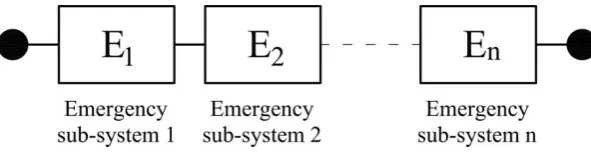
[image:4.595.126.470.256.354.2] CLE condition - Only essential activities for the emergency phase are considered and the majority of the buildings can undertake even severe damages. The CLE is repre-sented by a series of emergency sub-systems (see Fig. 2).
Figure 2:Urban system behaviour of the emergency limit condition (CLE)
[image:4.595.166.462.637.713.2](5)
(6)
(7) Each emergency sub-system includes a strategic building, whose operation is essential in the emergency phase, and all “interfering” buildings related to it. An interfering building is an ordinary building that faces a strategic connection route (from/towards a strategic building or an emergency area). The CLE survival probability (urban relia-bility) is evaluated using Eq. (5).
The component’s failure probability is defined according to the importance class
of buildings [16]. In particular, only the collapse, even partial, has to be prevented for interfering buildings ( = I, II), while any activity has to continue without interruption for strategic buildings ( = III, IV), see Eq. (6).
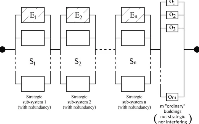
CLV condition - The whole settlement is considered. The complete functionality of all strategic buildings is guaranteed, and only modest-to-long interruption of ordinary urban functions is accepted. The behaviour of the city is represented by a series-parallel combination of strategic and ordinary sub-systems (see Fig. 3). Each strategic sub-system includes an emergency system (see CLE) along with their “redundancy”, i.e. other strategic systems of similar functions but not essential during the emergency phase. Ordinary sub-systems are considered in order to recover the settlement pre-seismic standard, including residential and economic activities. The CLV probability is evaluated using Eq. (7).
[image:5.595.130.465.530.738.2]
where accounts the interaction of the considered sub-systems and is defined by Eq. (6).
CLD condition - Conceptually similar to the CLV, the only short-to-modest or partial interruption of ordinary urban functions is accepted. The behaviour of the city is still represented by a series-parallel system (see Fig. 3), and the urban reliability is evalu-ated using Eq. (7) where is defined by Eq. (8). The CLD represents the possibility for the settlement to undergo limited damage after an earthquake in order to guarantee the shorter recovery time targeted by the urban management policy.
4 COMPUTER-AIDED RISK ASSESSMENT
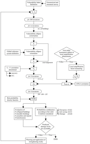
The MURA-SH method application can be time-consuming even for small settlements, mainly due to the complexity of the urban system reliability model and the multi-directional damage scenarios evaluation. The development of a computer-aided procedure for the MURA-SH numerical implementation becomes highly efficient from the computational point of view by using the MATLAB® software. The proposed numerical procedure is presented in herein.
The preliminary phase of the procedure consist on the definition of a .txt input file listing all the required data of the MURA-SH method. The input files format holds seven columns and as many rows as the number of buildings under assessment. The columns data contain the following information:
Vulnerability index along x-main direction, ;
Vulnerability index along y-main direction, ;
angle, see Eq. (4);
Structure Identifier (ID = 0 for masonry buildings, ID = 1 for R.C. buildings and ID = 2
for other structural types);
Local soil amplification factor related to each building, ,
Importance class, [16];
Occupants’ number.
All data are loaded from the input file and vulnerability ellipses are created for every build-ing usbuild-ing Eq. (4). Then, a coordinates transformation from the local to the global reference system is arranged. Finally, oriented vulnerability indexes are evaluated.
Indexes have to be converted into vulnerability values using Eq. (2) and (3) depend-ing on the structural type. Mean damage grades, , are evaluated for increasing intensities in the range with the equations of the Macroseismic method [8], but assuming the ductility factor, , equal to 2.1 for masonry buildings and 3 for other buildings. This as-sumption is introduced to consider that masonry structures can undergo local failure modes with limited ductility, when the global behavior is not guaranteed by the structural features.
damage probabilities are listed in matrixes for increasing intensities in the range
.
Total damage occurrence probability is used for losses evaluations, assessing the number of damaged or unusable buildings as well as the number of casualties and severed injured or homelessness. Equations to evaluate these data can be found in [3].
Finally, computed probabilities are combined to determine the reliability of the urban sys-tem, using equations introduced in §3.4, depending on the considered limit condition (CLE, CLV, CLD). The overall settlement reliability is evaluated for every direction and for in-creasing intensities . The proposed method application allows to easily pre-dict which earthquake direction will cause the worst damage scenario, and the evolution of the settlement performance from moderate to strong earthquake intensity.
[image:7.595.145.446.259.739.2]The overall MURA-SH numerical procedure is summarized in flowchart of Fig. 4.
5 MODEL VALIDATION ON A CASE STUDY
Italy has recently experienced a seismic event (PPE, 2012). Among all the affected settle-ments, the city of Concordia sulla Secchia has a peculiar historical city center, constituted by an heterogeneous mix of masonry and R.C. constructions, built in different periods of time and mostly in aggregate sequence. The Municipal authorities of Concordia commissioned a post-earthquake survey, regarding its CLE sub-system, to the University of Ferrara, gathering geometrical and structural features of the majority of the buildings. Thanks to the available information, the MURA-SH method has been applied to the CLE sub-system of Concordia and values have been obtained for the PPE event. The PPE registered intensity that hit he city was within the range (source: INGV) and the spatial distribution of seismic waves had the WNW-ESE predominant direction, i.e. 22° East (source: Italian Civil Protection).
Predicted damages were subsequently compared to the observed ones [10]. The compari-son shows that, for , the predicted damage matches the observed damage on 15 of the 42 total number of buildings, with a positive feedback on the 36% of cases; for
, the predicted damage matches the observed damage on 19 of the 42 total number of build-ings, with a positive feedback on the 45% of cases. Maximum registered during the PPE was equal to 8, and Concordia Sulla Secchia was the second most affected city. There-fore, it is reasonable to deduce that the actual intensity event that hit the settlement was closer to the upper bound of the measured range. The MURA-SH procedure needs to undergo more validations to improve the results accuracy. However, recognizing the task complexity, the obtained results are considered promising.
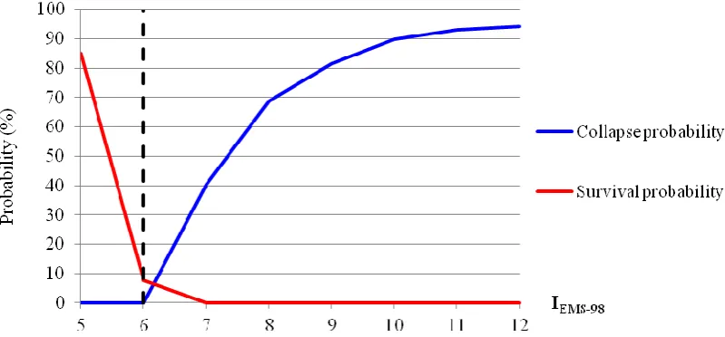
[image:8.595.93.493.473.659.2]Some numerical results obtained with the MATLAB® procedure are shown in Fig. 5, where the collapse probability is represented along with the survival probability (reliability) of the CLE sub-system. Starting from intensity , the collapse probability assumes positive values and rapidly increases while the reliability drops to zero, accordingly with the CLE series system definition.
Figure 5:Collapse probability and survival probability of Concordia sulla Secchia CLE sub-system for increasing seismic intensities.
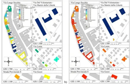
in-tensities. A unique “feature identifier”, also called FID, has to be assigned to every building in order to correctly refer corresponding output results. Assessment output values need to be previously organized in Excel files, using different sheets for increasing seismic intensities. Different colour maps can be used to represent the effects of increasing seismic intensities, and to identify most vulnerable areas.
[image:9.595.79.530.163.454.2]a) b)
Figure 6:Mapping results of the collapse probability for the Concordia sulla Secchia CLE sub-system for (a) and (b) .
6 CONCLUSIONS
In this work, a new methodology for the risk assessment at urban scale called MURA-SH method has been proposed. The MURA-SH method includes R.C. buildings in the evaluation, takes into account the effect of buildings aggregate sequence and performs multi-directional assessments, using the vulnerability ellipses. The MURA-SH method applies a performance-based approach to the settlement, with the definition of the urban system reliability. Thanks to its features, this method can predict whether the settlement will be able to withstand an earth-quake, and what performance loss it will endure. The MURA-SH method has been imple-mented in a computer-aided procedure using the MATLAB® software. The obtained output results can be easily visualized with simple curves and GIS maps.
The proposed MURA-SH method has been applied on the case study of the historical city centre of Concordia sulla Secchia (Italy). The settlement experienced the PPE (2012) and a post-seismic survey of the CLE sub-system was carried out. The possibility to compare pre-dicted damage scenarios to the observed ones has been extremely important to test the MURA-SH method accuracy. From the comparison, a matching rate of 45% ( )
REFERENCES
[1] Sendai Framework for Disaster Risk Reduction 2015-2030, Third UN World Confer-ence in Sendai, Japan, March 18, 2015.
[2] Council conclusions on participatory governance of cultural heritage. Council of the Eu-ropean Union, Brussels, 13 November 2014
[3] R. Vicente, S. Parodi, S. Lagomarsino, H. Varum, J. A. R. Mendes Silva, Seismic vul-nerability and risk assessment: case study of the historic city centre of Coimbra, Portu-gal. Bull Earthquake Eng (2011) 9:1067–1096, 2011.
[4] D. Benedetti, V. Petrini, On seismic vulnerability of masonry buildings: proposal of an evaluation procedure. Ind. Constr. 18:66–78, 1984.
[5] Gruppo Nazionale per la Difesa dai Terremoti – GNDT-SSN, Scheda di esposizione e vulnerabilità e di rilevamento danni di primo livello e secondo livello (muratura e ce-mento armato). Gruppo Nazionale per la Difesa dai Terremoti: Roma, 1994.
[6] M. Bezzazi, A. Khamlichi, J. R. A. González, Vulnérabilité sismique des constructions de type béton armé au Nord du Maroc. Canadian Journal Of Civil Engineering
35(6):600-608 · June, 2008.
[7] S. Giovinazzi, S. Lagomarsino, A macroseismic model for the vulnerability assessment of buildings. In: Proceedings of 13th world conference on earthquake engineering. Vancouver, Canada, 2004.
[8] A. Bernardini, S. Giovinazzi, S. Lagomarsino, S. Parodi, Matrici di probabilità di danno implicite nella scala EMS-98. XII Convegno ANIDIS “L’ingegneria sismica in Italia”, Pisa, 2007.
[9] G. Grünthal, European Macroseismic Scale 1998. Cahiers du Centre Européen de Géo-dynamique et de Séismologie, 15: p. 1-97, 1998.
[10] A. Basaglia, Seismic risk assessment and resilience enhancement at urban scale. The historical city center of Concordia sulla Secchia (MO) – Italy. MSc Dissertation, Uni-versity of Ferrara – Trinity College Dublin, October 14, 2015.
[11] A. Formisano, F. M. Mazzolani, G. Florio, R. Landolfo, Un metodo per la valutazione su larga scala della vulnerabilità sismica degli aggregati storici. STADATA, 2011.
[12] S. Grimaz, Valutazione della vulnerabilità sismica di edifici in muratura appartenenti ad aggregate strutturali sulla base di analisi a posteriori. Ingegneria sismica, Anno X – N. 3 – Settembre-Dicembre, 1993
[13] W. Fabietti, Vulnerabilità e trasformazione dello spazio urbano. Alinea, Firenze, 1999.
[14] S. Staniscia, Definizione e valutazione di condizioni limite urbane a supporto della pia-nificazione urbanistica preventiva del rischio sismico. PhD in Progettazione ed Inge-gneria del Sottosuolo e dell'Ambiente Costruito, ciclo XXVI. Università degli Studi “G. d’Annunzio”, Chieti-Pescara, 2013.
[15] M. Olivieri, et al., Rischio sismico urbano: indicazioni di metodo e sperimentazioni per l’analisi della Condizione limite per l’emergenza e la Struttura urbana minima. DGR n. 793 del 18/7/2011 – Determinazione dirigenziale n. 3928 23 Maggio, 2012.