Volume-7 Issue-1
International Journal of Intellectual Advancements
and Research in Engineering Computations
Automatic pothole detection while driving
R.Raja
1, S.Gnanaprakash
2, G.Mugunthan
2, M.Ganesan
21
Assistant Professor, Department of Electrical and Electronics Engineering, Muthayammal
Engineering College, Rasipuram
2
UG Scholar Department of Electrical and Electronics Engineering, Muthayammal Engineering
College, Rasipuram
ABSTRACT
One of the major problems in developing countries is maintenance of roads. Well maintained roads contribute a major portion to the country‟s economy. Identification of pave- ment distress such as potholes and humps not only helps drivers to avoid accidents or vehicle damages, but also helps authorities to maintain roads. This paper discusses previous pothole detection methods that have been developed and proposes a cost-effective solution to identify the potholes and humps on roads and provide timely alerts to drivers to avoid accidents or vehicle damages. Ultrasonic sensors are used to identify the potholes and humps and also to measure their depth and height, respectively. The proposed system captures the geographical location coordinates of the potholes and humps using a global positioning system receiver. The sensed-data includes pothole depth, height of hump, and geographic location, which is stored in the database (cloud). This serves as a valuable source of information to the government authorities and vehicle drivers. An android application is used to alert drivers so that precautionary measures can be taken to evade accidents. Alerts are given in the form of a flash messages with an audio beep.
Index Terms:
Android application, GSM SIM900, GPS, PIC16F877A, Ultrasonic sensors.INTRODUCTION
NDIA, the second most populous Country in the World and a fast growing economy, is known to have a gigantic network of roads. Roads are the dominant means of transportation in India today. They carry almost 90 percent of country‟s passenger traffic and 65 percent of its freight [1]. However, most of the roads in India are narrow and congested with poor surface quality and road maintenance needs are not satisfactorily met. No matter where you are in India, driving is a breath-holding, multi-mirror involving, potentially life threatening affair.
Over the last two decades, there has been a tremendous increase in the vehicle population. This proliferation of vehicles has led to problems such as traffic congestion and increase in the number of road accidents. Pathetic condition of
roads is a boosting factor for traffic congestion and accidents. Researchers are working in the area of traffic congestion control [2], an integral part of vehicular area networks, which is the need of the hour today.
Roads in India normally have speed breakers so that the vehicle‟s speed can be controlled to avoid accidents. However, these speed breakers are unevenly distributed with uneven and unscientific heights.
Potholes, formed due to heavy rains and movement of heavy vehicles, also become a major reason for traumatic accidents and loss of human lives. According to the survey report “Road Accidents in India, 2011”, by the ministry of road transport and highways, a total of 1,42,485 people had lost their lives due to fatal road accidents. Of these, nearly 1.5 per cent or nearly 2,200 fatalities
were due to poor condition of roads. Figure 1 portrays the condition of roads with killer potholes. To address the above mentioned problems, a cost effective solution is needed that collects the information about the severity of potholes and humps and also helps drivers to drive safely. With the proposed system an attempt has been made to endorse drivers to ward off the accidents caused due to potholes and raised humps.
The remaining sections of the paper are as follows: section II emphasises on the related work that has been done and is going on in the field of detection of potholes and humps. Section III discusses the various components used in the proposed system. Section IV describes the architecture and implementation of the proposed system. Experimental results of the proposed work are presented in Section V. Section VI talks about conclusion and future scope.
Fig. 1. Condition of roads with potholes.
RELATED WORK
Pavement distress detection is an intriguing topic of research and researchers have been working on pothole detection techniques. This section gives a brief description about the existing solutions for detecting potholes and humps on roads.
Moazzam et al. [3] have proposed a low cost model for analysing 3D pavement distress images. It makes use of a low cost Kinect sensor, which gives the direct depth measurements, thereby reducing computing costs.
The Kinect sensor consists of a RGB camera and an IR camera, and these cameras capture RGB images and depth images. These images are analysed using MATLAB environ- ment, by extracting metrological and characteristic features, to determine the depth of potholes. Youquan et al.
[5] developed a model to detect the three-dimensional cross section of pavement pothole. The method makes use of LED linear light and two CCD (Charge Coupled Device) cameras to capture pavement image. It then employs various digital image processing technologies including image pre-processing, binarization, thinning, three
with the central application, where it can directly communicate with the social network. All the collected data is stored at central repository for further processing. Although this method communicates traffic events with other drivers, it increases the cost and complexity of implementation.
Mednis et al. [8] have proposed a real time pothole detection model using Android smartphones with accelerometers. Modern smart phones with android OS, have inbuilt accelerometers, which sense the movement and vibrations. The accelerometer data is used to detect potholes. Different algorithms such as Z-thresh, which measures the acceleration amplitude at Z-axis, Z-diff to measure the difference between the two amplitude values, STDEV (Z) to find the standard deviation of vertical axis acceleration and G-Zero are used to identify potholes. Zhang et al. [9] have made use of stereo camera images coupled with a disparity calculation algorithm to identify potholes. The location coordinates of the potholes are also captured and stored in the database. Strutu et al. [10] have proposed a method for detecting defects on the road surface using accelerometers. It also makes use of GPS system to identify the exact location of the defects. Pothole detection algorithm runs on a mobile platform (moving vehicles), which is installed with accelerometer, GPS, local computer and a wireless router. The sensed data is communicated to the central database using primary access points and secondary access points which can be used for future processing. However, installing wireless router and local computer on all mobile platforms and setting up access points turns out to be quite expensive. Murthy and Varaprasad et al. [11], have proposed a system that detects potholes based on a vision based approach. The pictures of the road surface are captured using a properly mounted camera. The images are then processed using MATLAB to detect the occurrence of potholes. It is a 2D vision based solution and works only under uniform lighting conditions and also the system does not involve any kind of warning system. The above solutions are limited only to the identification of a pothole. These solutions do not provide any aid to the driver to avoid accidents due to potholes and humps.
Rode et al. [4] have proposed a system in which, Wi-Fi equipped vehicles collect information
about the road surface and pass it to the Wi-Fi access point. The access point then broadcasts this information to other vehicles in the vicinity in the form of warnings. However, the system turns out to be an expensive one as all vehicles should be installed with Wi-Fi stations and more number of access points have to be set up. Venkatesh et al.
[12] have proposed an intelligent system that has made use of laser line striper and a camera to detect and avoid potholes. This system maintains a centralized database of the location of potholes. It also sends warning messages to the nearby vehicles about the occurrence of potholes using Dedicated Short Range Communication protocol. Hegde et al. [13], have proposed an intelligent transport system to detect potholes. It makes use of ultrasonic sensors to detect the presence of potholes. This system also sends warning messages to all the vehicles in the range of 100 meters using Zigbee module. However, the system provides warnings after detecting the potholes which does not effectively help drivers to avoid potential accidents.
Although this is an accurate and efficient method for detecting potholes, the cameras capture shaky images due to uneven road surface, which reduces the efficiency of pothole detection.
Chen et al. [17] proposed a system for detecting potholes using GPS sensor and three-axis accelerometer. The outputs are taken from the GPS
sensor and three-axis accelerometer and fed into data cleaning algorithm. In the second part of the implementation the inputs to the algorithm are processed for power spectra density (PSD) to calculate the roughness of potholes. After analysing, roughness is classified into different levels.
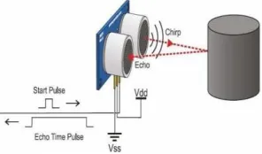
Fig. 2. Working principle of ultrasonic sensor.
COMPONENTS USED IN THE
PROPOSED SYSTEM
The proposed system offers a cost effective solution for detecting potholes and humps on roads and notifying drivers about their presence. Components used in the proposed work are as follows:
PIC 16F877A Microcontroller: Peripheral
Interface Control (PIC 16F887A) is a 40 pin microcontroller with 8k program memory. It is widely used due to its low cost, high application support and wide availability. Microcontroller is the heart of the proposed system and is responsible for performing various tasks starting form processing all the sensor inputs to alerting the driver.
Ultrasonic Sensors HC-SR04: The HC-SR04 is
an active ultrasonic sensor and contains a transmitter and a receiver. It is used to measure distance at which, objects are placed in front of it. The ultrasonic sensor transmits high frequency sound waves and waits for the reflected wave to hit the receiver. The distance is calculated based on the time taken by the ultrasonic pulse to travel a particular distance [19]. The working principle of this device is shown in figure 2. There are different types of ultrasonic sensors with different transmission ranges and angles of detection. The HC-SR04 sensor work at frequency of 40 KHz and
can measure distances of the objects in the range 2 to 400 cm with a 15° angle of detection.
GPS Receiver: Global Positioning System
(GPS) is a satellite navigation system and is used to capture geographic location and time, irrespective of the weather conditions. It is maintained by the U.S. Government and is freely available to anyone who has a GPS receiver. It obtains the GPS information from satellites in National Marine Electronics Association (NMEA) format. The NMEA has defined a standard format for the GPS information. This is followed by all the satellites. The standard defines various codes such as GLL-Latitude/Longitude data, GSV–Detailed satellite data and RMC-Minimum Recommended Data [14].
GSM SIM 900: Global Standards for Mobile
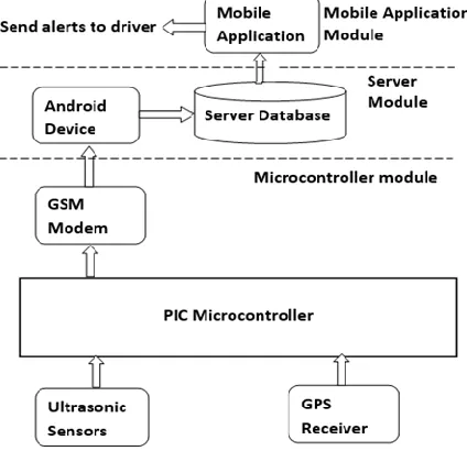
Fig. 3. Architecture of the proposed system.
ARCHITECTURE &
IMPLEMENTATION
The architecture of the proposed system is shown in figure 3. It consists of 3 parts; microcontroller module, server module and the mobile application module. Microcontroller module is used to gather information about potholes and humps and their geographical locations and this information is sent to the server. Server module receives information from the microcontroller module, processes and stores in the database. Mobile application module uses information stored in the server database and provides timely alerts to the driver.
Microcontroller Module: This module consists of 4 components, namely, PIC 16F877A microcontroller, ultrasonic sensors, GPS receiver and GSM modem. Ultrasonic sensors are used to measure the distance between the car body and the road surface and this data is received by the microcontroller. The distance between car body and the ground, on a smooth road surface, is the threshold distance. Threshold value depends on the ground clearance of vehicles and can be configured accordingly. If the distance measured by ultrasonic sensor is greater than the threshold, it is a pothole, if it is smaller, it is a hump otherwise it is a smooth road.
The GPS receiver captures the location coordinates of the detected pothole or the hump and sends messages to the registered mobile SIM using GSM modem. This registered mobile SIM is present on the android device that acts as server. The messages sent include information about depth of the pothole or height of the hump and its location coordinates.
Server Module: This module consists of two
parts; the android device and the database. It acts as an intermediary layer between the microcontroller module and the mobile application. The server module is implemented as an android application that runs on a device and is responsible for reading messages sent by the registered mobile SIM present in the microcontroller module. It processes the contents of this message and stores it in the database (cloud). Integrating sensor networks with cloud and Internet of Things [18], it is possible to allow broader access to sensor data.
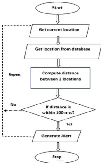
Mobile Application Module: This module is
stored in the server database. The distance between the vehicle location and the pothole location stored in database is computed. If the distance between the two is within 100 meters, an alert message
pops up on the mobile screen. This message is accompanied with an audio beep so that the driver can differentiate it from other flash messages.
Fig. 4. Workflow of mobile application.
Table I: Information about potholes and humps collected in simulated test environment
Fig. 6. Message sent to android device about the pothole and hump locations.
EXPERIMENTAL RESULTS
The working model of the proposed system is shown in figure 5. It was tested in a simulated environment with artificial potholes and humps. The mode was also tested in real time by fixing it on a motor bike (Honda Activa).
Tests were carried out in two phases. In the first phase, information about potholes and humps was recorded and stored in the server database. In second phase, alerts were generated based on pothole and hump information stored in database. While testing in the simulated environment, the
microcontroller module was fixed on a toy-car and the threshold value was configured to 5 cm. During the tests it was found that the microcontroller module worked as expected to identify potholes and humps. Table I shows a set of potholes and humps identified by the system in the simulated environment. Information about potholes and humps was successfully sent to the android device (server). The snapshot of these messages can be seen in figure 6. The server processed the messages received and stored in the database.
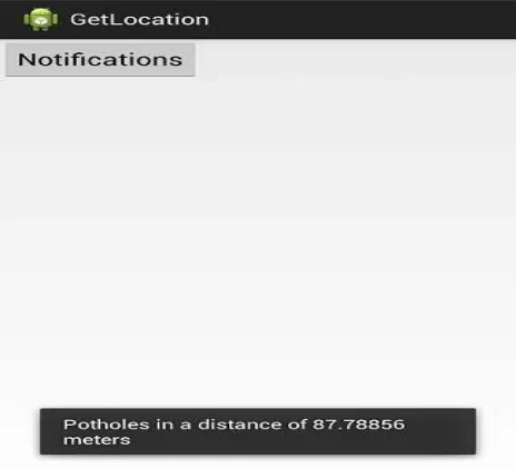
phase of testing, the mobile application that generates alerts was successfully tested by moving the toy-car on routes containing potholes and humps and alerts were generated for potholes and humps recorded in the first phase. Figure 7 shows an alert generated by this application.
Figure 8 shows the real time testing of the proposed model. The microcontroller module was
fixed on Honda Activa and the threshold distance value was configured to 16 cm, which is the ground clearance for Honda Activa. The vehicle was moved on Bangalore roads for the purpose of recording information about potholes and humps, and the test results were as expected. Table II shows a set of potholes and humps detected during real-time tests.
Fig. 7. Pothole alert displayed on the mobile phone.
Table II: Information about potholes and humps collected during real-time testing
CONCLUSION AND FUTURE
RESEARCH WORK
The model proposed in this paper serves 2 important purposes; automatic detection of potholes and humps and alerting vehicle drivers to evade potential accidents. The proposed approach is an economic solution for detection of dreadful potholes and uneven humps, as it uses low cost ultrasonic sensors. The mobile application used in this system is an additional advantage as it provides timely alerts about potholes and humps. The solution also works in rainy season when potholes are filled with muddy water as alerts are
generated using the information stored in the database. We feel that the solution provided in this paper can save many lives and ailing patients who suffer from tragic accidents.
The proposed system considers the presence of potholes and humps. However, it does not consider the fact that potholes or humps get repaired by concerned authorities periodically. This system can be further improved to consider the above fact and update server database accordingly. Also, Google maps and SATNAV can be integrated in the proposed system to improve user experience.
REFERENCES
[1]. India Transport Sector. [Online]. Available:
http://web.worldbank.org/WBSITE/EXTERNAL/COUNTRIES/SOUTHASIAEXT/ EXTSARREGTOPTRANSPORT/0„contentMDK:20703625~menuPK:
868822~pagePK:34004173~piPK:34003707~theSitePK:579598,00.html, accessed Mar. 16, 2015.
[2]. R. Sundar, S. Hebbar, and V. Golla, “Implementing intelligent traffic control system for congestion control, ambulance clearance, and stolen vehicle detection,” IEEE Sensors J., 15(2), 2015, 1109–1113.
[3]. I. Moazzam, K. Kamal, S. Mathavan, S. Usman, and M. Rahman, “Metrology and visualization of potholes using the microsoft Kinect sensor,” in Proc. 16th Int. IEEE Conf. Intell. Transp. Syst., 2013, 1284–1291. [4]. S. S. Rode, S. Vijay, P. Goyal, P. Kulkarni, and K. Arya, “Pothole detection and warning system:
Infrastructure support and system design,” in Proc. Int. Conf. Electron. Comput. Technol., 2009, 286–290. [5]. H. Youquan, W. Jian, Q. Hanxing, Z. Wei, and X. Jianfang, “A research of pavement potholes detection based
on three-dimensional projection transformation,” in Proc. 4th Int. Congr. Image Signal Process. (CISP), 2011, 1805–1808.
[6]. J. Lin and Y. Liu, “Potholes detection based on SVM in the pavement distress image,” in Proc. 9th Int. Symp. Distrib. Comput. Appl. Bus. Eng. Sci., 2010, 544–547.
[7]. F. Orhan and P. E. Eren, “Road hazard detection and sharing with multimodal sensor analysis on smartphones,” in Proc. 7th Int. Conf. Next Generat. Mobile Apps, Services Technol., 2013, 56–61.
[9]. Z. Zhang, X. Ai, C. K. Chan, and N. Dahnoun, “An efficient algorithm for pothole detection using stereo vision,” in Proc. IEEE Int. Conf. Acoust., Speech Signal Process., 2014, 564–568.
[10].M. Strutu, G. Stamatescu, and D. Popescu, “A mobile sensor network based road surface monitoring system,” in Proc. 17th Int. Conf. Syst. Theory, Control Comput. (ICSTCC), 2013, 630–634.
[11].S. B. S. Murthy and G. Varaprasad, “Detection of potholes in autonomous vehicle,” IET Intell. Transp. Syst., 8(6), 543–549, Sep. 2013.
[12].S. Venkatesh, E. Abhiram, S. Rajarajeswari, K. M. Sunil Kumar, S. Balakuntala, and N. Jagadish, “An intelligent system to detect, avoid and maintain potholes: A graph theoretic approach,” in Proc. Conf. Mobile Comput. Ubiquitous Netw, 2014, p. 80.
[13].S. Hegde, H. V. Mekali, and G. Varaprasad, “Pothole detection and inter vehicular communication” in Proc. IEEE Int. Conf. Vehicular Electron. Safety (ICVES), 2014, 84–87.
[14].GPS. NMEA Data. [Online]. Available: http://www.gpsinformation.org/ dale/nmea.htm, accessed 19, 2014. [15].P. More, S. Surendran, S. Mahajan, and S. K. Dubey, “Potholes and pitfalls spotter,” IMPACT, Int. J. Res.
Eng. Technol., 2(4), 2014, 69–74.
[16].X. Yu and E. Salari, “Pavement pothole detection and severity measure- ment using laser imaging,” in Proc. IEEE Int. Conf. EIT, 2014, 1–5.
[17].K. Chen, M. Lu, X. Fan, M. Wei, and J. Wu, “Road condition monitoring using on-board three-axis accelerometer and GPS sensor,” in Proc. Int. ICST Conf. Commun. Netw. China, 2011, 1032–1037.
[18].F. Li and P. Xiong, “Practical secure communication for integrating wireless sensor networks into the Internet of Things,” IEEE Sensors J., 13(10), 2013, 3677–3684.
[19].A. Carullo and M. Parvis, “An ultrasonic sensor for distance mea- surement in automotive applications,” IEEE