DEVELOPING THREE-DIMENSIONAL (3D) TOPOLOGICAL MODEL FOR 3D GIS
Alias Abdul Rahman
Research Project (IRPA) Vot # 74152 Project # 09-02-060097 EA001
Faculty of Geoinformation Science and Engineering Universiti Teknologi Malaysia
ABSTRACT
Permodelan data spatial 3D merupakan salah satu masalah dalam GIS 3D. Banyak aplikasi GIS dan gunapakai GIS semakin memerlukan kepada data spatial 3D dan kebanyakan data seperti ini disimpan dalam Geo-DBMS. Tetapi kebanyakan Geo-DBMS ini tidak menyokong primitif data spatial 3D. Penyelidikan ini menfokus kepada pembangunan topologi yang menyokong data spatial 3D dan seterusnya digunapakai dalam permasalahan analisis 3D bagi data spatial 3D. Untuk ini, beberapa tool sedia ada telah digunakan, seperti Autodesk 3D Map dan Oracle Spatial. Projek ini juga telah menerbitkan satu model data spatial 3D, iaitu Condedensed Spatial Model (CoS). Model ini berguna untuk mendapatkan topologi 3D bagi data spatial 3D.
TABLE OF CONTENTS
CHAPTER TITLE PAGE
1 INTRODUCTION 1
1.1 Introduction 2
1.2 Problem Background 2
1.3 Problem Statement 6
1.4 Goal of the study 6
1.5 The objective of the thesis 7
1.6 Research Scope 7
1.7 Thesis Contribution 8
1.8 Organization of the Thesis 9
2 LITERATURE REVIEW 10
2.1 Background and State-Of-The-Art 10
2.1.1 Developments in the Field of Information Technology 10
2.2 An Introduction into Distributed Computing 11
2.3 Traditional Client-Server Architectures 14
2.3.1 Component Object Servers 16
2.3.2 XML and Web Services 18
2.4 3D Spatial Data on the Web: The Development towards Web- Enabled Geo- Informatics 21
2.4.1 History of GIS: From Monolith Systems to Distributed GIS 21
2.4.1.1 Distributed GIS 22
2.4.1.2 Open Geo-Standards and their Value for “The Spatial Web” 25
2.5 3D Spatial Data Management 29
2.5.1 Database Concepts 29
2.5.2 Spatial Databases and 3D Geo-information 33
2.6 Concepts for 3D Data Modeling 37
2.6.1 3D Geometry 41
2.7.2 VRML/X3D 49
2.7.3 JAVA 3D 50
3 RESEARCH METHODOLOGY 52
3.1 Introduction 52
3.2 Data Sources and Instrumentations 53
3.3 Research Life Cycle 54
3.3.1 Background analysis 55
3.3.2 Areas to be evaluated for considerations 55
3.3.3 Preliminary analysis to architectural design based on the previous evaluation 55
3.3.4 Discussion towards new techniques 56
3.3.5 Improvement 56
3.4 Operational Framework 56
3.4.1 Problem Formulation 58
3.4.2 System Design Methodology (Phase 2) 58
3.4.3 Identify components and elements 58
3.4.4 System Designing 59
3.4.4.1 Integrating system components and Implementation 60 3.4.4.2 System Performance Testing 60
3.4.5 Report Writing (Phase 4) 60
3.4 Summary 61
4 CONDENSED SPATIAL (CoS) MODEL 62 4.1 Introduction 62
4.2 GEOMETRIC PROPERTIES 63
4.2.1 Node 63
4.2.2 Line 64
4.2.3 Face 64
4.3.1 Definition of primitive objects 67
4.3.2 Definition of Feature objects 69
4.4 Architecture for Web-Based 3D GIS 75
4.4.1 VRML and X3D 75
4.4.2 PHP and VRML/X3D Integration 76
4.5 Prototype and Process details 77
4.6 Summary 79
5. EXPERIMENTS AND RESULTS 81
5.1 Introduction 81
5.2 Experimental Setup 82
5.3 Oracle Spatial Geometry Schema 83
5.4 Autodesk Map 3D Schema Table 84
5.5 Synchronization between Oracle and Map 3D schemas 85
5.6 Querying 3-D Condense Spatial (CoS) Model 87
5.7 Dynamic 3D Scene Generation on Web 88
6. CONCLUSION AND FUTURE WORK 93
6.1 Introduction 93
LIST OF TABLES
TABLE TITLE PAGE
2.1 Possible attributes and relationships of a particular
Geographic feature 15
2.2 Summary of the data models started from 1964-1990 26
2.3 Summary of the data models started from 1991-1995 “Relational Approach” 29
2.4 Summary of the data models started from 1991-1995 “Object Oriented Approach” 32
2.5 Summary of the data models started from 1996-Up to date 35
2.6 Summary of the problems of data models 36
3.1 Simple and Structured objects of the Attribute data class 47
4.1 Examples of changes applied to GeographicFeatureState Objects 65
4.2 Simple and Structured objects of the Attribute data class 67
4.3 Signature for Stack Operations 70
4.4 Signature describing the type system 71
5.1 Classes of operations on non-temporal types 84
5.2 Classification of non-temporal types 85
5.3 Unary Predicates 87
5.4 Set operations 90
5.5 Aggregate operations 92
5.6 Boolean Operations 94
6.1 Specifications of Software’s used in testing 101
6.2 Specifications of Test System 102
LIST OF FIGURES
FIGURE TITLE PAGE
2.1 Snapshot Data Model 26
2.2 Cube System Logical View 28
2.3 Triad Framework Data Model 31
2.4 Integrated TGIS Data Model 32
2.5 Event-Based ST Data Model 34
3.1 Research Operational Frame work 40
3.2 Model Development 45
3.3 Data sources and instrumentation used in research 51
4.1 Objects 54
4.2 “Identifies” Relationship 55
4.3 Entity and its Attributes 56
4.4 Generalization 57
4.5 Specialization 58
4.6 Association 58
4.7 Aggregation 59
4.8 Main-Class Structure of the model 60
4.9 Phenomena Classification Hierarchy 61
4.10 Model Development 64
4.11 Detailed Structure of Spatio-Temporal Object-Relational Model 66
4.12 The Spatial Data Types 72
6.1 Possibility of Spatiotemporal queries on STORM 106
6.2 Query execution time using STORM 107
6.3 Query to Measure Rainfall at Specific Contour 108
6.4 Query to Measure Rainfall effect on Contour’s Height 109
6.6 Measuring Storage Efficiency Among three Models 112
6.7 Possibility of Spatiotemporal queries on STORM for Rivers and Dams case study. 113 6.8 Query execution time for STORM using rivers and
dams case study 114 6.9 Query to know the dams on rivers and their specifications 115 6.10 Query to Measure length of river 116 6.11 Spatio-temporal Queries Evaluation for Among Data models 118
LIST OF ABBREVIATIONS
AD Attribute Data ADT Abstract Data Type
DBMS Database Management System ERM Entity Relationship Model
ESTDM Event-based Spatio-temporal Data Model
GF Geographical Feature GFS Geographical Feature State
GIS Geographical Information Systems GP Geographical Phenomena
GPS Global Positioning System HIS Hydrological Information System
ITS Intelligent Transport System
MHIS Malaysian Hydrological Information System ODMG Object Database Management Group
OMT Object Management Techniques
OODBMS Object-oriented Database Management System ORDBMS Object-Relational Database Management System RDBMS Relational Database Management Systems
SAR Synthesized Aperture Radar SD Spatial Data
SDT Spatial Data Types
SQL Structured Query Language STD Spatio-Temporal Databases
STGIS Spatio-temporal Geographical Information Systems STORM Spatio-temporal Object-relation Model
TD Temporal Data
CHAPTER 1
INTRODUCTION
1 Introduction
Currently, a very strong development in the field of software applications is moving towards web-enabled systems. The reason for this is because information technology and its infrastructure are offering more and more possibilities to share data, applications and their logic within networking environments. Here, the most obvious example is the success of the Internet as a platform for communication in all kind of variants. Within the last years, it has been proven that Internet applications are working effectively and everybody is able to benefit from it. Among many others, the success of e-commerce is reflecting this story of success. However, not only the Internet is
considered as “web-enabled”. For example, there are a large number of web-applications within local area networks (LAN), like an enterprise communication platform. In the context of web-enabled applications, the science of information technology deal with distributed computing.
magazines monthly. Such systems are called web-enabled- or Internet GIS. Recently, the general term of “Distributed GIS” is becoming more and more popular as well. Here, the OpenGIS Consortium (OGC) plays an important role. As an organization of many companies and institutes, the OGC is standardizing data sources and interfaces for geo-related Web Services – in this context called “GeoServices” (ESRI, 2001). Presently, there are already GeoServices available and accessible. However, most of the current web-orientated applications are mainly restricted to visualization (Peng and Tsou, 2003). Less comprehensive GeoServices are available for the second dimension -
three-dimensional (3D) GIS is limited to visualization only. Systems which are offering core 3D functionality including data management, -edition, -analysis and interactive user interfaces are only available for single desktop use.
1.2 Problem Background
In terms of possible applications, especially managers are able to benefit from 3D GIS as a base for their work. Their duty is to cover the whole process of planning
complex city centers, for instance construction simulation, emission/waste control, disaster management or telecommunication/energy supply. Beside, tourism and facility management are able to benefit from virtual worlds as well (Altmaier and Kolbe, 2003). Laurini points out, that different authorities can benefit from information systems for urban planning. Furthermore, the public participation in decisions around this topic can also be improved. Here, especially 3D applications are able to assist users and to simplify complicated workflows (Laurini, 2001). Therefore, the demands for web-orientated 3D information systems will be increasing in future.
As a conclusion to the discussed tendency towards distributed systems, the general research question follows:
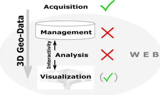
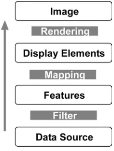
In order to give an appropriate answer, the research is considering the four principles of GIS. Here, the topics of 3D data management, analyzing and querying data as well as publishing/visualizing 3D maps within a web environment are considered, whereas 3D data acquisition will not be the main target of the research itself. Coors (2003) points out that the processing of 3D geo-data within GIS still has to improve (Coors, 2003). Figure 1 is showing the four main stages within GIS in conjunction to their present availability for the third dimension.
Figure 1: The 3D Geo-Data Workflow within GIS
As shown in Figure 1, the data management respectively the storage is most important for further processes like 3D analysis and 3D visualization as well as for providing interactivity. In fact, it is regarded as the base of any further step. In contrast to a 2D environment, the third dimension is requesting different aspects. One important topic which can not be the same is the underlying data management. Previous and current research is concluding that the underlying spatial data for web-enabled 3D GIS is by far more complex than 2D geo-information (Coors, 2003). For this reason different
characteristics in terms of data modeling and –management in order to integrate 3D GIS analysis and to visualize results have to be addressed.
Fundamental research in the field of 3D spatial data modeling for urban environments has been done mainly by Molenaar (1990), Pigot (1992), Tempfli and Pilouk (1994), Pilouk (1996), Zlatanova (2000), Pfund (2001), Shi et al (2003) and Coors (2003). The specific task of web-orientated systems has been covered by Zlatanova (2000), Coors (2003) and Vries and Stoter (2003) before. However, more web-specific research has been demanded as a conclusion.
Although the most recent efforts are considering 3D visualization on the Web, applications which are dynamically serving interactive 3D geo-worlds are not fully available yet. Functionality like 3D data analysis - on top of a reasonable data
management - in terms of GeoServices is still missing (Coors, 2003). Therefore, another research question will be:
Is it possible to realize GI-Services for complex 3D spatial data tasks?
Previous studies on the dynamic creation of interactive 3D worlds from spatial databases have been done by Kofler (1998), Zlatanova (2000), Coors (2003) and de Vries and Stoter (2003). Their prototype systems have shown solutions which have been integrated into web architectures. Standalone as well as browser-based user agents were used to create intuitive graphical user interfaces which are able to interact with 3D geo-information. Here the main question will be:
Are current web-visualization techniques able to visualize 3D spatial data in real-time? Are there reasonable interfaces to access and interact with the data?
The research will give a scientific view about 3D GIS. Therefore, the right answers will show the research results. In addition, the summary and conclusion will face towards further discussion around the topic of web-enabled 3D GIS.
Therefore, useful existing research and approaches has to be evaluated first. Here, web integrity of 3D geo-information and its visualization are among the most critical topics. More precisely, 3D spatial data and its complex structure as well as its huge amount of information have to be considered since web-orientated applications have some
limitations in terms of performance – especially band-width. Based on a reasonable data management concepts of real 3D analysis functionality and 3D visualization methods will be discussed. Regarding the data management, there is still a lack of proven concepts. Whereas the storage of 3D geometry can be realized easily, 3D topological modeling is most critical. It is among the most problematic aspects how to model complex buildings and transform their geometry into databases. Therefore, one research question is “what are the existing 3D topological models which can be used for 3D GIS in Web
environments?”
Furthermore, the issue around storing corresponding attributes and textures has to be addressed. Besides, a concept for implementing spatial operators has to be constructed. Here, the question is if there are any spatial operators for 3D GIS in Web environment. In addition, the question whether methods of 3D spatial analysis have to be implemented on database or application level is an issue. In order to access, query and visualize 3D data, the integration of user agents to do so has to be evaluated. Here, the tasks on an
In order to prove web-integrity of 3D geo-information, this research will include an implementation which is showing the proposed concepts of 3D data management, 3D analysis and 3D visualization using state-of-the-art techniques. The solution should be harmonized with common standards like the OGC or World Wide Web Consortium (W3C) recommendations. Furthermore, the implementation should show if recent web-technologies are suitable for web-orientated 3D GIS. In order to introduce practical applications specific use cases for solving problems in the field of urban environment will be set up.
1.3 Problem Statement
The aim of this research is to design and develop a 3D spatial model and also discover current issues regarding web-orientated 3D GIS and to develop concepts to solve untouched problems on 3D web-based GIS.
The following research questions are addressed to solve the problem:
a) How to properly manage the 3D spatial data together into a database?
b) How to manage 3D spatial data relationships?
c) How effectively Spatio-temporal queries can be handled by a model using object-relational approach.
1.4 Goal of the Study
1.5 Objective
Objectives of this research can be divided into the main intentions which should be achieved through short-term goals. The research objectives are to:
1- Investigate current and existing concepts and approaches for web-enabled 3D GIS.
2- Design and develop a practical spatial data model for web-orientated 3D geo information in urban environments and setup a reasonable system architecture for a 3D GIS.
3- Develop and implement a prototype system including necessary web-based 3D GI-Services web-based on the developed spatial data model and the constructed system architecture.
4- Evaluate and test the designed and implemented prototype in a web environment.
1.6 Scope of Research
Overall, this research concentrates on web-enabled 3D GIS. Because this topic is too general and broad, the research concentrates on specific topics. The following limitations and requirements outline the research in detail.
a) Reviews and comparisons of the existing data models in the area of 3D spatial data modeling and other related areas of geographical information system.
c) Define a set of 3D Spatial queries to evaluate the proposed 3D Spatial data model with the specified parameters based on the handling of 3D spatial data, effectiveness in terms of space, less data redundancy and consistency.
d) Analysis and evaluation of the results of 3D Spatial queries after applying them on the proposed 3D spatial data model.
1.7 Thesis Contribution
In this thesis, data model is designed for 3D geographical information system, which can handle the 3D spatial data and its relationships. It provides an applicable platform for the efficient synthesis of 3D spatial data and related queries.
In General, the major contribution described in this thesis can be summarized as follows:
a) Design of general structure for modeling 3D spatial data in 3D geographical information system.
b) Defining the relationship rules for 3D spatial data such and also their applications on 3D GIS.
c) Efficient query handling for Spatio-temporal data by using the measures such as how better model support the analysis of spatio-temporal data, efficiency in terms of time, less data redundancy and consistency.
1.8 Thesis Organization
The aim of this proposal is to introduce the research subject in detail. The thesis is divided into the following chapters.
Chapter 2 is based on the core literature review. The second chapter gives detailed information about the background and the state-of-the-art of web-orientated 3D GIS. Here, fundamental information about developments in the field of Information
Technology and about 3D topology will be covered. Furthermore, recent research around the topic of 3D data management as well as 3D modeling of spatial data will be
discussed. Here, already available approaches will be discussed.
Chapter 3 – Methodology - the research methodology - proposes how the goals will be achieved. Therefore, the four phases of literature review, conceptual design of the system, implementation as well as testing and evaluating the system are differentiated. The last Chapter of this proposal sets expected results of the project. The appendix is including the research schedule and a draft of the thesis structure.
Next, Chapter 4 is the design and architecture of the developed system. In this Chapter we have explained our designed 3D topological model along with the architecture of the system developed in this research.
Afterwards - in Chapter 5 – This chapter describes the results and experiments performed for this research to by implementing proposed methodology to get the desired results.
CHAPTER 2
LITERATURE REVIEW
2.1 Background and State-of-The-Art
As stated before, the topic of web-enabled 3D GIS has already been discussed by several people. Based on the literature review, the following sections give a brief overview about the status of current activities and technologies related to the research.
2.1.1 Developments in the Field of Information Technology
Information Technology is the base field for any computer-related tasks. Therefore, it can be seen as the key which is affecting many different fields of the
2.2 An Introduction into Distributed Computing
The increasing penetration of computers changed the way of working in many ways. One idea computerization brought up was the task of Electronic Data Interchange (EDI). In fact, the beginning of distributed computing is originated here, because the requirements of EDI were concluding in applications we are recognizing as distributed systems today. At the beginning of this “new age”, the intention was only to share text data more easily through networks. Other media elements, like images, have already been served since the early nineties. Later, more functionality e.g. in terms of user-interaction was added to web sites. For example, users were already able not only to retrieve data. Furthermore, they could edit and manipulate data stored somewhere else. On the technical side, client-server architectures were the base for these operations.
Today, while the technical base can be still a client-server model, the evolution reached another level. In addition to share data, users are able to offer applications and their logic as well. Most recently, the development is more and more including a process oriented Web. In this context, we are talking about web-enabled information systems or
distributed systems/computing. Distributed means, the locality of the components or objects comprising an application can be on different computers connected through a network.
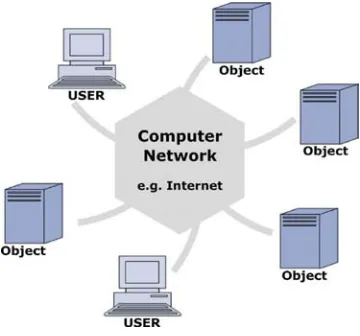
Figure 2 is showing the principal architecture of distributed systems (Nagappan et al, 2003).
This very general figure is showing a distributed computing architecture with including several objects and clients. The amount of the objects and users is indefinite and therefore the value can be very high in large-scale systems. Distributed computing is inheriting the concepts of Object-Oriented Programming (OOP). Because of that, all the advantages of OOP are transformed into distributed systems as well.
In some cases, the term of distributed computing is not defined in the same way (Erlanger, 2002). It is bothering the field of grid computing as well and one can get confused about it. However, these terms in are generally different and defined as the following. In contrast to distributed computing, grid computing is facing the use of many machines – combined to a computer grid - in order to perform large-scale processing tasks. Within a computer grid, the resources of many computers are merged to a more powerful machine to run certain tasks more quickly.
Distributed computing changed many things in the field of software application
development. Whereas traditional software was designed for the use on certain machines only, distributed components are more flexible and open. Beside the usual advantages of OOP, the following characteristics are showing why distributed programming became so popular and why it is unique (Nagappan et al, 2003):
- Distributed computing is supporting the idea of the collaboration of multiple applications. Hence, the construction of core systems using different components of other “expert” systems is possible more easily.
- Scalability and Extensibility: as stated before, within a distributed computing environment, there are no limits regarding the use for components. Applications can be extended easily, whereas certain objects can be reused as well. This means that distributed components of system are not only restricted to this one. Other systems are able to benefit from them as well.
- Because distributed systems are recognized as decentralized, usually massive applications are split into smaller components automatically. As a result, the development cycle time of distributed systems is lower compared to traditional mainframe applications.
- Cutting costs: once the infrastructure has been set up, there are nearly no further costs incurring. Reusing components, especially those ones which are not used at certain times, is the base for efficient use of the infrastructure.
However, distributed systems have to be deployed for the right purpose. For example, as stated before, there is no need to process small-scale tasks within distributed systems. Furthermore, if networking infrastructure is not available, distributed computing fails from the roots. Beside this, other problems are occurring while the realization of distributed computing. These are especially security and privacy questions, service payment possibilities and common standard implementations.
2.3 Traditional Client-Server Architectures
A very important milestone towards distributed programming was the
introduction of client-server systems. Such systems were offering advanced possibilities within computer networks for the first time. Client-Server models are used until now. Whereas the client is responsible for handling the presentation and the logic of the user application, the server is organizing the application and is hosting or accessing the data. Data source can be hosted on the same machine or retrieved from another component In terms of physical abstraction a client-server system is containing at least two-layers - known as two-tier systems as well. Within a two-tier application, there are two computers involved. One is hosting the client and the other one is playing the server role.
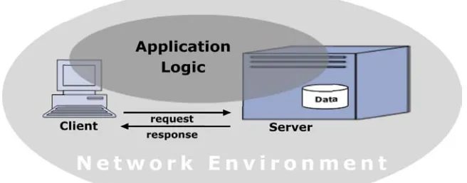
Figure 3 is showing the general architecture of a client-server system.
Figure 3: General Architecture of a Client-Server System
Clients - or in other words user agents - are providing the graphical user interface (GUI) for the human-machine interaction. In this case, they are offering possibilities to interact with servers. In order to do so, the client is sending requests to a server and is handling the server’s response in form of information representation. Clients are also able to host certain parts of the application itself (see below). In contrast to the client, the server is hosting application logic which is able to handle the client’s request. These can include for example running certain threads in a Java environment which are retrieving
response/request protocol models. As transport layer the usual types of protocol for certain networks are used. Protocols like TCP/IP offer services for the transportation …
In client-server architectures, the most critical aspect is the balance between the client and the server. This means, a server can provide more or less application logic – the client is behaving correspondingly. Peng and Tsou are calling this act of balance “Client/Server System Partition” (Peng and Tsou, 2003). Therefore, the centroid of the bubble representing the “Application Logic” in
Figure 3 can be relocated horizontally. If the majority of the application logic is hosted by the server it is recognized as “thick”. Consequently, the client can be regarded as “thin”. Similarly, if the server is hosting less application logic, it will be called “thin” – the client in such system would be regarded as “thick”.
Typical examples are web-enabled systems. Here, the client is using a Web browser to represent the data, whereas on the server-side there is a Web-server taking care of the communication. As transport layer, so called Web-protocols like the HyperText Transfer Protocol (HTTP) are used. Other typical examples are the generic database server like Oracle. Here, the data itself it accessible through the database server. The database client can be any application which has the ability to connect to the database server.
The introduction of client-server architectures brought significant improvements. In contrast to mainframe systems in which clients are “dumb”, clients and servers are able to share application logic. Therefore, servers are able to process more requests – even several servers can be in use. This aspect is marking the beginning of decentralized systems (Peng and Tsou, 2003).
it is even impossible due to the fact that some systems are getting very complex (Nagappan et al, 2003).
2.3.1 Component Object Servers
The introduction of Component Object Servers was marking a new period of distributed computing. Its systems which can be regarded as advanced client-server systems are unifying the concepts of Object-Oriented Modeling (OOM) and Distributed Computing Environment (DCE). The concept is proposing that different interfaces are specifying methods which are allowing the use within heterogeneous systems. Therefore, systems based on Components Object Servers are by far more flexible and interoperable than usual client-server architectures. Software components and its objects can be accessed, instantiated and therefore used remotely from other computers. In order to call functions on different machines, communication is based on Remote Procedure Call’s (RPC). Roughly, RPC works similar to ordinary function calls in software development (Gisolfi, 2001).
In addition to communicating through the request/response model, many Component Object Server Systems support interaction through “messaging” which is based on
passing/queuing. Here, the server and the client do not necessarily have to run at the same time. This is the reason why this type of communication is characterized as
“asynchronous”. For example, if the server is not accessible, messages are able to be queued until the server can handle them. Therefore, there is a guarantee that the call is delivered (Nagappan et al, 2003).
Most famous contributors for the implementation of distributed systems are the open standard Common Object Request Broker Architecture (CORBA), the distributed
“messaging” are categorized as Message Oriented Middleware (MOM) (Peng and Tsou, 2003).
In contrast to simple client-server architectures, Component Object Servers have brought significant improvements in the field of distributed computing. One important
characteristic is such systems are by far more comfortable to maintain than usual client-server systems. Characteristics like scalability, interoperability have made progress, too. Cross-platform applications are possible. However, there are still many things missing which are required in order to offer proper distributed computing. First, Component Object Servers depend on single implementations. Although they have been developed for several platforms respectively different implementations and they claim
interoperability. This condition is not reaching higher-level services. Gisolfi is showing the reality and concluding that certain protocols are propriety developed and therefore not interoperable in practice (Gisolfi, 2001). Related to this problem, Nagappan et al is pointing out that for example Microsoft’s DCOM technology is limited to Microsoft’s application environment and therefore platform locked-in (Nagappan et al, 2003).
Second, many distributed computing implementations are very complex in practice. Very deep knowledge of the specific implementation is compulsory. Therefore existing
developing resources can hardly be used. As a conclusion at this stage of the evolution, distributed computing needs standards and agreements in order to become more open and more interoperable (Nagappan et al, 2003).
Regarding the topic of distributed virtual worlds, Diehl discusses how to implement CORBA and Java RMI based multi-user worlds. His approach proves that these technologies are able to achieve the tasks of distributed virtual worlds (Diehl, 2001).
2.3.2 XML and Web Services
“XML Web Services”. In fact, XML-based applications are spreading everywhere. This new family of technologies is used to share data between different applications, platforms or computers. Furthermore, XML Web Services are offering the possibility to share applications throughout a network of computers like the Internet. Therefore, one is able to conclude that XML is offering the possibility to improve the interoperability of information systems. In addition, XML is helping to decentralize those systems. In order to lighten the mystery around XML, the following paragraph is showing some
characteristics.
XML is a standard - recommended by the W3C - which is setting rules and guidelines for describing structured data. Perhaps the most important feature of XML is its text-based way of storing data. Furthermore, another characteristic of XML is the strict
differentiation between content (elements and attributes), structure (schema) and styling. In fact, the success of XML is showing the need for non-proprietary ways of storing any kind information. Therefore, many XML derivates – which can be standards as well - were developed over the last years. This is the reason why the hype around XML as a keyword should be re-named in the “XML family”. In order to mention a few of these corresponding technologies, there is XSLT (Extensible Stylesheet Language for
Transformations) for transforming one XML document into a different structured XML file. Furthermore, there is XSD (XML Schema Definition) to define the structure of a XML document even with following the rules of XML itself. Related to visualize data, there is SVG (Scalable Vector Graphics) and X3D (Extensible 3D) available. In order to define geographic data according to the XML definitions, the OGC introduced the
Geographical Markup Language (GML). As stated before, all these are markup languages and are according to the set of rules given by XML. And one can recognize, the XML standard can be used to store/organize/share and visualize data as well as to construct applications. Since XML became a “Web Recommendation” – which means nothing else than “Web Standard” - in 1998, its ideas have been adopted by almost every software vendor.
Figure 4 is showing the concept of web services as a simple operational model.
Figure 4: The Operational Model of XML Web Services (based on Nagappan et
al, 2003; Maruyama et al, 2002)
As shown in
Figure 4, three important components are involved in every Web Service operation. These are namely, the user or service requestor, the repository or registry (service broker) and the service provider. In this model, the client is finding and requesting the service. The repository registers and lists the Web Services with its attributes whereas the
provider is processing the Web Service and publishing XML-conform data. Transformed into the client-server model, the user is acting as client and the service provider as server. Because the service broker is located between the client and the server, it is regarded as middleware. In order to implement more complex structures, services can be chained (Open GIS Consortium, 2004b).
In order to share data, XML is the base for any format. As transport layer common Internet protocols like HTTP or FTP can be used. On top of them, the Simple Object Access Protocol (SOAP) is the key standard. As it is a protocol which is standardized and XML-based as well, SOAP is responsible for the communication between the
components. SOAP supports both, messaging and request/response communication models. Like protocols in Component Object Server architectures, SOAP also defines ways to perform remote procedures calls. In order to describe and connect to Web
Description, Discovery and Integration) are used. Whereas WSDL is responsible for describing network services, UDDI defines standard interfaces for dynamically finding other web services. The big advantage of XML Web Services compared to the
technologies mentioned before is that it can communicate with any kind of object infrastructure (Coyle, 2002).
Despite the described ways of implementing Web Services, there is the possibility to use ebXML for creating global electronic marketplaces as well. This standardized solution provides a core possibility - by defining the necessary protocols – to implement an electronic marketplace. Therefore, it fits better into B2B processes and it is just mentioned as a sake of completeness (Nagappan et al, 2003; ebXML, 2004).
Because all the different protocols and standards sound confusing, unfortunately we still face some problems around XML Web Services. Some protocols/recommendations did not become open standards yet and are not recognized by the main vendors. Even important standardization committees and the software industry sustain a common Web Services model, specific implementations are proprietary developed – one example is the definition of a common security model for XML Web Services. At this stage enterprises even compete and do not cooperate at all (Open GIS Consortium, 2004b).
Nevertheless, in order to realize and host useful Web Services, among others the frameworks of .NET (Microsoft) and Java and its derivates (SUN) are used. Whereas “Microsoft = Microsoft”, Java has been adopted by companies like IBM, Oracle and Hewlett Packard. Now, the common thing is that all of them are facing towards XML Web Services (Coyle, 2002).
2.4 3D Spatial Data on the Web: The Development towards Web-Enabled Geo- Informatics
2.4.1 History of GIS: From Monolith Systems to Distributed GIS
30 years ago, mainframe computer systems were offering geo-functionality and geo-data. At this time, only these huge and expensive systems were offering the
execution of the complicated tasks of Geoinformatics. Although computer networks have already been involved, these systems are recognized as monolith or centralized systems. All Geo-Information logic and the spatial data where hosted on a mainframe computer. Dumb clients could access the system through a computer network, however too many users were slowing down the processing speed enormously. At this time, such systems were very expensive and therefore only affordable by big enterprises or institutions. This is the reason for a low general accessibility.
In the eighties, concluding to the introduction of Personal Computers (PC), the period of Desktop GIS began. A Desktop GIS consists of a PC which is hosting its own GIS and the data locally. Later, geo-information could be retrieved through computer networks, too. Because of its relatively cheap asset cost, Desktop GIS was spreading out quickly. Henceforth, by far more users were able to take advantage out of GIS. Although every single GIS installation had to be licensed separately. However, the increasing number of individual users was raising new issues. Because GIS were hosted on different platforms and networks interaction became very complex and sometimes was not even possible any more. Especially the communication between applications and sharing data were
demanding better concepts of Distributed GIS.
systems are using the network’s components or objects to store, process and visualize geographic information. Therefore, one can recognize such systems as open and accessible in better ways. The modern characteristics of Distributed GIS are going
towards interoperable systems. This means, they should not depend on certain devices, its platforms and further restricted technologies and data formats. However, this
development is still in progress (Peng and Tsou, 2003).
2.4.1.1 Distributed GIS
Distributed GIS is describing a selection of GIS nodes or objects using computer networks as the primary medium to access, manage, analyze and visualize geographic information. The objects together are achieving a GIS comparable to a centralized
desktop or mainframe systems. However, the physical aspect is completely missing since the components are used within a networking environment. In addition, characteristics of Distributed GIS are accessibility and extendibility – experts are talking about
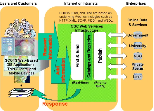
Figure 5: Distributed GIS scenario using the OGC Web Service architecture (Open GIS Consortium, 2004b)
Because many people are concerned about these critical aspects, general questions like “How can anybody benefit from Distributed GIS?” are occurring – here, anybody is including the GI-community as well as the public. In order to find the right answers – besides inheriting the advantages of distributed computing in general (see Chapter 0) -, problems appearing in current GIS solutions have to be realized. At the moment, one is able to differentiate between several causes of non-interoperability which are isolating spatial data. These can be summarized into technical and semantic non-interoperability. Whereas the first one is facing propriety GIS solutions including internal data formats, the later one is dealing with problems around internal data structures and schemas. All of them can be solved by developing web-orientated GIS. Beside general web standards, special “geo-related” rules and standards have to be settled to achieve interoperable systems. Most recently, standardization organizations like the OGC or the ISO/TC 211 (ISO/TC 211, 2004) are working hard to define the necessary spatial standards (see next section). If the community – here especially the main GIS vendors – are taking care of these regulations, the chances are very high to establish real web-enabled GIS. The general tendency is more and more GIS software is implementing standards and working towards interoperable systems. Hence, the OGC is predicting the so-called “Spatial Web” (Open GIS Consortium, 2004b). As one important result the value of geo-information and its technologies will be increasing. Everybody in the field of geo-information can take profits out of the development towards web-enabled interoperable systems (Open GIS Consortium, 2004b).
Beside these theories, certain components of Distributed GIS have already been
Moreover, the following thoughts are providing some expressions which communities are able to benefit from Distributed GIS. Most recently, especially e-government scenarios that are proposing Spatial Data Infrastructure (SDI) can take advantages of interoperable systems. Distributed GIS is regarded as a reasonable way to achieve SDI. In many
countries and even across continents, there are ongoing efforts to disseminate spatial data in order to use them. Since the Web became the dominant platform even a global SDI is not an illusion anymore. Common scenarios of a Spatial Data Infrastructure are including connected GI nodes which are provided by government agencies, universities,
enterprises, organizations and others. The different “data provider” updating and maintain the certain information. Such a model is proposing a decentralized data management. Furthermore, the distributed objects spread the spatial data and offer certain geographic processes like spatial analysis as well. Any constellation could be possible. A common Spatial Data Infrastructure obviously has many advantages. First, costs can be cut for example through the reuse of data. Therefore it is not necessary any more to spend that much money and time on data acquisition by several parties at the same time. If more and more people are using the data, it will become cheaper and cheaper, too (Lake, 2004). Furthermore, the dissemination of spatial data is the base for many useful applications. Not only the GI-community is taking profits out of SDI, moreover everyone would benefit from better accessible data. Here, location services and street routing for car navigation are typical example which the public has already accepted and using of spatial data. Third, the advantage of higher GIS customization in terms of usable GI-modules is obvious as well. Since distributed computing is based on modularity GIS benefits out of this characteristic. Whereas today, core monolith software kits have to be purchased even if only one small component is needed, Distributed GIS are offering the possibility to purchase only the needed components (Peng and Tsou, 2003).
2.4.1.2 Open Geo-Standards and their Value for “The Spatial Web”
important characteristics have to be fulfilled. Reichardt (2003) is introducing them in detail. Among others, the most important ones are:
Standards should be open and accessible freely by everyone. Furthermore, standards should be created by non-propriety and not-profit organizations. In most cases, these are consortia including main vendors, government agencies and research institutions as their members (Reichardt, 2003).
The reasons why open standards are necessary should be obvious to everyone, too. Beside the requirements for general agreements in distributed systems there are other side effects. In the past, GIS vendors have competed to establish their products and its linked data formats. As a result of establishing standards, vendors can concentrate more on security and other application aspects like analysis (Lake, 2004).
In the past, client-server systems – especially vendor based webmapping solutions – were facing a lack of interoperability. Kolodziej talks about “technology islands” and describes a corresponding scenario (Kolodziej, 2003). Frankly, these islands were not able to communicate and therefore to share information between them. However, he points out that the situation has already improved (Kolodziej, 2003).
As a conclusion, for distributed systems standards or common agreements are a must. As stated before, it is known that different platforms and applications are “troublemakers” in terms of sharing data and resources efficiently. Beside the general computing standards, geo-information needs its specific rules for defining characteristics like data semantic, interfaces and processing services. Furthermore, architectures for the concrete
overlapping and different parts of the specifications. In relation to this research (see next Chapter), Oosterom et al are pointing out that both standards are well harmonized in terms of defining the same geometric and topological primitives (Oosterom et al, 2002).
The reason for different developments can be found in the background of these two committees. Whereas the ISO/TC211 has its members in the public and government sector, the OGC is a consortium by mainly companies and institutions. Because of this different background, the history of the standard development was different. The OGC is mainly focusing on interoperable systems which are combining existing GIS solutions. The ISO/TC211 has its origin in constructing a Spatial Data Infrastructure for nations and certain regions (Peng and Tsou, 2003). In the case of this research, mainly the
specifications of the OGC will be recognized. The reason for this is, nearly every
important company and many research institutions are members of the OGC – therefore it is recognized as the de-jure standardization organization in the field of Geoinformatics. Beside, as stated before OGC and ISO/TC211 are cooperating more and more and the standards are even merging.
The OGC is categorizing its catalog of specifications into two groups. First, there are the OpenGIS Abstract Specifications. Its purpose is to define conceptual models in order to specify implementation interfaces. The different abstract specifications are divided into 16 topics. Among others, the most important topic of the OpenGIS Abstract
Specifications for this research is “Topic 1”, the “Feature Geometry”. The corresponding “Simple Feature Specification” is defining the schema of geometric features and their topological relationships.
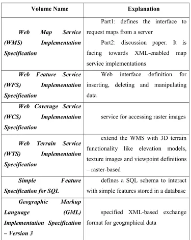
Table 1: Research Related OpenGIS Implementation Specifications
Volume Name Explanation
Web Map Service (WMS) Implementation Specification
Part1: defines the interface to request maps from a server
Part2: discussion paper. It is facing towards XML-enabled map service implementations
Web Feature Service (WFS) Implementation Specification
Web interface definition for inserting, deleting and manipulating data
Web Coverage Service (WCS) Implementation Specification
service for accessing raster images
Web Terrain Service (WTS) Implementation Specification
extend the WMS with 3D terrain functionality like elevation models, texture images and viewpoint definitions – raster-based
Simple Feature Specification for SQL
defines a SQL schema to interact with simple features stored in a database Geographic Markup
Language (GML) Implementation Specification
– Version 3
specified XML-based exchange format for geographical data
Feature Service, Web Coverage Service and most recently the Web Terrain Service are not only separately existing specifications. Furthermore, the can be used complementary (Kolodziej, 2003). Kolbe and Altmaier are showing one possible system architecture for using these services. Furthermore, they discuss the raising issues by implementing 3D worlds using existing OGC Implementation Specifications. As a result, they propose the W3DS portrayal service for 3D spatial data. The reason is, because so far there is no standard to visualize interactive 3D models. The WTS is restricted to static images only. Furthermore, there is no standardized way to implement necessary 3D features like backgrounds or characteristics of the atmosphere (Kolbe and Altmaier, 2003).
In order to realize the vision of the “Spatial Web”, the OGC has set up the OGC Web Service Phase 2. The intention is, to build up a core framework of implementations in order to achieve interoperable GIS (Open GIS Consortium, 2004a).
Beside the specifications and initiatives, the OGC is publishing other documents like discussion- and white papers as well as reports. The main purpose of them is to introduce and explain new thoughts and technologies related to geo-information. In order to cover all necessary standards for this research, the certain specification will be mentioned within its specific chapter.
2.5 3D Spatial Data Management
The data management considers mainly where to store and how to organize
geo-information. In contrast to the 3D data modeling (see below) it is not necessarily related to web-oriented systems. The following paragraphs give a brief overview about general database concepts theories and its use in the field of Geoinformation. Furthermore, tasks of spatial data management with the interests in the third dimension will be discussed.
Any complex GIS project consists of a Database Management System (DBMS). The reasons why DBMS are more appropriate have been discussed for decades already. Connolly and Begg (2002) have provided a brief overview why DBMS have many advantages compared to the data storage within files (Connolly and Begg, 2002). Databases offer a more efficient way to store data. Characteristics include the control of data redundancy which is reducing the risk of inconsistency as well and the possibility of sharing information. The later aspect is very important because DBMS are offering multi-user accessibility. In general, the data accessibility is improved through querying e.g. through the Structured Querying Language (SQL). Therefore, data manipulation processes like updating and deleting are by far easier to achieve. Important side effects are the positive querying performance, data security/backup possibilities and the integratability into different system environments. Although DBMS have some
disadvantages like complexity and high costs, the advantages the field of Geoinformation can take are preponderating. As stated before, complex GIS projects request the storage within databases and a proper management of them.
Although the diagrams are good ways to keep the track of concepts, intricate models can become very complex and obscure. Furthermore, Rigaux et al points out that the
relational model is not suitable to host geographic data properly because of its inherent spatial component. Whereas usual business applications are containing large but simple datasets, geographic information has the characteristic to be large and very complex (Rigaux et al, 2002).
In contrast to the relational model, the object-oriented (OO) approach to model databases is using a completely different concept. As the name implies – the corresponding
development adopted OOP, the need for keeping data in similar ways on database level increased. Whereas relational database models have to be transformed into the object models of applications in order to achieve GIS, the object-oriented conceptual database schema can be mapped directly to the object-oriented application. Since this
transformation is chore, object-oriented databases have a big advantage compared to relational ones (Shekar and Chawla, 2003). Furthermore, Franklin points out, that object-oriented models are by far more elegant to design than relational ones (Franklin, 2001). Shekar and Chawla add that especially spatial entities like lakes, road networks and cities are perfectly fitting in an object-based approach (Shekar and Chawla, 2003). Gruber is going one step further and claims that state-of-the-art urban data management deals with complex data and requirements and therefore has to replace the relational model on database level (Gruber, 1999). One example for the implementation of an object-oriented data model has been developed by Abdul-Rahman (2000). Briefly, he converted the Pilouk’s Tetrahedral Network (TEN) into an OODBMS (Abdul-Rahman, 2000).
However, in association with the object-oriented approach there are several
disadvantages as well. These are mainly the missing overall accepted querying standard and the lack of experience. Other problems like the lack of implementations are
associated to them. On the market of OODBMS, there is less competition compared to the one of RDBMS. In order to improve the quality of the implementations, fair and open competition is one fundamental aspect (Connolly and Begg, 2002). Another disadvantage is that many applications have already been realized in a RDBMS and their migration to OODBMS is among the biggest challenges (Franklin, 2001).
Applications of Geoinformation are using both concepts. Whereas more simple projects are fine with adopting the relative model, more complex spatial data is able to benefit from the object-oriented as well. Thus, the modular approach – named object-relative database - has become popular in the field of Geoinformation over the last years. Shekar and Chawla are proposing an architecture including an object-related database
and associated functionality (see below). This is most appropriately done by using an object-relative database backend (Shekar and Chawla, 2003). In this context Rigaux et al
talks about an integrated approach (Rigaux et al, 2002); Oosterom et al propose the integrated architecture as well; in conjunction with a corresponding DBMS they are using the term “Geo-DBMS” (Oosterom et al, 2002). Object-relational databases are offering the possibility to define individual spatial data types as well as implementing pre-defined data types through objects. These objects will be stored in the cells of a certain table. The tables are located in a relational model. The objects are regarded as the extension of relational databases. The advantage of using objects as data types compared to store spatial data for instance in a pure relational model is obvious. The spatial
information becomes handier and complicated transformation can avoided in favor. Furthermore, certain standard object behaviors are represented by an object’s methods. Thus, typical spatial operations like an area calculation can be performed on the database level rather than developing certain functionality for each system. In this context,
Connolly and Begg are circumscribing this characteristic with the terms of “reuse” and “sharing”. Among usual database requirements, spatial extensions should implement spatial indexes (Shekar and Chawla, 2003) as well as topology in order to offer reasonable ways to query data. As a conclusion one can claim that advanced data
management applications - like GIS - are able to benefit from OR-DBMS (Connolly and Begg, 2001).
However, there are a couple of problems which have to be considered. First, OR-DBMS can become very complex and obscure. Beside, most problematic with the use of spatial OR-DBMS is the missing common standards. At the moment, still some inconsistency between the object-relational extensions of different database vendors remains. Here, the missing implementation of a standardized querying language has to be mentioned. Although SQL3 - which standardizes for instance the creation of individual abstract data types – has been published long time ago (in 1999), many of the current implementations are using proprietary techniques. However, SQL itself is not covering any “spatial” features since it is developed for general querying purpose. Therefore, the OGC
(see before). It is defining certain spatial data types and functions for spatial data
querying (Shekar and Chawla, 2003). Oosterom et al points out that only simple features are covered. The recommendation – or in OGC language the implementation
specification - for abstract features like sophisticated topology is still missing (Oosterom
et al, 2002).
Comprising different models to store data, the four-quadrant view proposed by Stonebracker, 1996 is very useful (see
Figure 6). Whereas the x-axis is reflecting the degree of data complexity, the y-axis shows the search as well as the multi-user support possibilities.
Figure 6: The Stonebreaker View (Connelly and Begg, 2001)
Referring to
Figure 6, GIS applications are fitting best in the object-relational approach. In fact, spatial data is in most cases intricate and has to be updated frequently. Furthermore, multi-user support is a requirement for GIS as well.
2.5.2 Spatial Databases and 3D Geo-information
Spatial databases which are gathering the third dimension are considered as 3D Spatial Databases. Therefore, the Spatial-DBMS (SDBMS) should offer a core
implementation of storing 3D geo-information. The general requirements for spatial databases can be defined as follows (based on Güting, 1994):
- offering spatial data types and its implementation - providing a corresponding query language
- creating spatial indexes - processing of spatial analysis
Oosterom et al extend these requirements by the topological aspect (Oosterom et al, 2002). The requirements are at least valid for multi-dimensional data as well.
In order to look closer on 3D spatial data, Geo-information has to be divided into the geo-data itself and their associated attributes. Since storing attributes is not that critical, a closer look at the geo-information itself is necessary. As mentioned before, the aspects of 3D geometry and 3D topology have to be considered while dealing with 3D spatial data. This is a must because spatial functionality strongly requires them as a base for
calculations (see 0). Compared to the second dimension, 3D data is much more complex. Whereas 3D geometry is easy to implement, 3D topology is most critical. In order to implement topology spatial operations are necessary, too. These important topics will be discussed in detail later (see below).
The second requirement is the provision of an associated querying language. Since SQL is a general querying standard, there is no feature for spatial querying. Thus, the
(Egenhofer, 1994). Beside the query, especially the representation of the result has to be considered (Güting, 1994). Most important, standards for accessing, querying the database and displaying the results are important. Thus, in 1999, the Open GIS
Consortium has set up the “Simple Feature Specification for SQL” which is proposing spatial data types and operations (see before). The later one can be categorized into basic operations for all geometric data types, operations for simple topological queries and general operations for spatial analysis. However, the standards lacks of sophisticated integration of topology and metric spatial relationships like directional queries (Shekar and Chawla, 2003). Furthermore, query results should be represented in standardized ways as well – e.g. GML as a XML derivate can be used. In the practice, spatial querying languages are implemented through the DBMS. Therefore, examples are provided
through Oracle Spatial or PostgreSQL/PostGIS.
R-Trees can be used in order to implement LOD, Octrees are mainly utilized to speed up spatial queries. Besides, the object-relational database “PostgreSQL” and its spatial extension PostGIS are implementing its own indexing method called GIST (Generalized Search Trees). However, it has been not proven for the third dimension. Because of the PostgreSQL page size, objects larger than 8K are not supported in R-trees (Ramsey, 2003).
The third requirement is the integration of spatial analysis and operations. Therefore, the database level should provide basic GIS operations like spatial selection, spatial join, spatial function application like intersect and other spatial set operations. Whereas the first two are not that critical and can be achieved by usual queries, the later tasks have to be considered more complicated. They do not fit into a “SELECT … FROM …
WHERE” routine because they are on a more abstract level of spatial operations. As stated before the “Simple Feature Specification for SQL” is standardizing the most common operations. An overview can be found by Shekar and Chawla (Shekar and Chawla S., 2003). The task of spatial analysis - linked to the associated querying language as well - is already reaching application level. Many GIS application are implementing these methods already by itself (Güting, 1994). However, providing common tasks already on database level has many advantages. Overall, an intelligent implementation can improve the performance of certain processes. The reason for this is because the user access on the database will be reduced and therefore the critical
bottleneck of the database interface is bypassed (Jansen, 2003). Furthermore, the term around Geo-information is becoming more accessible without purchasing specific and expensive GIS. As a conclusion, a more simple system integration of Geo-information is one major advantage.
Today, spatial database implementations are wide spread. Nearly every main database vendor is providing spatial extensions in order to penetrate into the GIS market.
partly 2D topology as well as 2D spatial indexes-, 3D spatial data is not fully integrated yet. Unfortunately not many DBMS are offering support for 3D indexing – however, Zlatanova (2000) shows that R-trees can be implemented into non-spatial databases as well. Furthermore, the integration of 3D topology is still missing (Stoter and Zlatanova, 2003b). However, Oracle recently announced the integration of topology and R-trees up to 4D in its database Spatial Extension of Oracle 10g (Lopez, 2003). In addition, Ravada is giving a detailed introduction about Oracle’s topology implementation (Ravada, 2003). On the research side, Arens (2003) is extending spatial databases with an individual spatial (volumetric) data types, namely the 3D polyhedron primitive (Stoter and Oosterom, 2002; Arens et al, 2003).
In conjunction with the management of 3D data, the possibilities of manipulating data including the creation, the edition and the query of stored information is significant as well. Here, proper access to the DBMS is most important. The database interface can be an important bottleneck in systems – especially once one is dealing with the third dimension. Furthermore, applications have to be provided in order to create the spatial data types and populate the database. Especially the complexness and abstractness of 3D geo-data are requesting reasonable graphical user interfaces therefore. Although, the newest product lines of CAD respectively GIS software are supporting these tasks quite well, there is no implementation which is using a real web environment (Stoter and Zlatanova, 2003b). For instance, Nebiker presents the DILAS approach which is offering 3D visualization on the Web (see below). However, the data edition is only possible through an Intranet solution (Nebiker, 2003).
Finally, in order to transform real-world 3D objects into database system different
concepts for 3D data modeling have to be used. The following paragraph is giving a deep introduction about recent literature and research around the concepts of 3D data
modeling.
3D data modeling deals mainly with certain ways to transform real-world 3D objects into spatial databases. Therefore, specific concepts have been introduced and several
implementations have proven to be sufficient for modeling real-world 3D objects within spatial databases. Without regarding the dimension, there are several possibilities to store the geometry of spatial objects.
First, the Spaghetti Model is able to hold spatial objects. Here, the geometry of a vector-based object is stored in collection which can contain any kind of feature like points or lines. Furthermore, objects are stored independently of others. Therefore, data
redundancy is not implied. For instance a line used by several objects is represented twice or more. The only advantage is its simplicity. Geo-information modeled as “Spaghettis” can be extended easily and the reconstruction in order to visualize is not critical as well. However, very limited GI-functionality can be processed on top or the data has to be re-modeled to other models like the topological one (Rigaux et al, 2002). Concluding, data stored in the Spaghetti Model can be regarded as “dumb” and therefore less useful for any spatial analysis.
Second, the topological model is most important. As stated before, topology is dealing with the relationships between spatial objects. Due to the fact that geographical data can be raster- or vector based we have to distinguish between two completely different kinds of topological concepts. First, and less important for this research, there are the
topological relations between raster cells. Molenaar stated that these are necessary for window and filter operations (Molenaar, 1998). Second, 2D topology of vector data is based on the geometrical objects of point, line and polygon objects. Extending a topological model to the third dimension, a body object has to be introduced. Each
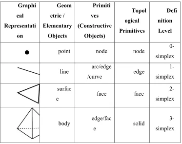
In order to get used to common expressions around 3D modeling of geographic information, Table 2 gives a brief overview.
Table 2: Expressions according to their Status Modeling Level Graphi cal Representati on Geom etric / Elementary Objects Primiti ves (Constructive Objects) Topol ogical Primitives Defi nition Level
point node node
0-simplex
line arc/edge
/curve edge
1-simplex
surfac
e face face
2-simplex
body edge/fac
e solid
3-simplex
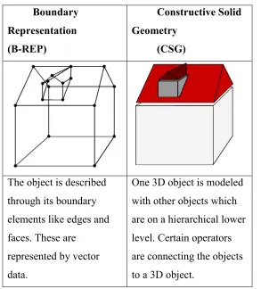
Table 3: Modeling Concepts in 3D GIS (based on Pfund, 2001) Boundary
Representation (B-REP)
Constructive Solid Geometry
(CSG)
The object is described through its boundary elements like edges and faces. These are
represented by vector data.
One 3D object is modeled with other objects which are on a hierarchical lower level. Certain operators are connecting the objects to a 3D object.
The B-REP approach is using common objects like nodes, edges and surfaces in order to model buildings. In order to include topological relations, the body object has to be added. The B-REP approach is becoming very close to proper implementation of a topological model. Only some more constraints have to be added in order to fulfill the requirements of a 3D GIS. In contrast to the B-REP, the CSG is using space primitives in order to construct buildings. These are geometrical elements like cuboids, cones, spheres etc. The CSG can not host topology – it has to be computed every time (Pfund, 2001).
In order to model 3D objects, the OGC is proposing a differentiation between geometrical and topological models. The next paragraphs about 3D Geometry and 3D Topology are giving an introduction what has already been done in past research.