How Time and Intensity of
Clipping Affect Tall Bluebell’
WILLIAM A. LAYCOCK AND PAUL W. CONRAD
Principal Plant Ecologist and Associate Range Scientist, Intermountain Forest and Range Experiment Station,2
Forest Service, U. S. Dep. Agr., Logan, Utah
Highlight
Removing 40, 70, and 100% of the foliage of tall blue- bell plants for 4 consecutive years significantly reduced production, height, and stem number. Clipping during flowering and fruiting damaged plants more than treat- ment before flowering. Grazing systems for tall bluebell ranges should allow for deferment every two or three years to enable plants to maintain vigor and high production.
Tall bluebell (Mertensia arixonica var. leonar- diij3 is one of the major forbs in aspen and subal- pine herbaceous ranges in Utah and surrounding States (Houston, 1954; Ellison, 1954). It produces abundant succulent foliage and is highly palatable to both sheep and cattle (U.S. Forest Service, 1937; Matthews and Conrad, 1968). In spite of its high palatability, tall bluebell sometimes forms almost pure stands in areas that originally had a mixed- forb community. It matures by midsummer and dries rapidly; thus becoming useless as forage. This occurs even earlier in areas dominated by tall bluebell. However, tall bluebell’s successional status in the plant community and the effects of different seasons and intensities on this valuable forage species are not clear.
This study was undertaken to obtain background information to use in designing grazing systems for ranges containing tall bluebell. The objectives were to determine: (1) the effect of different levels and times of foliage removal on herbage produc- tion, number of stems, and stem height of tall bluebell; and (2) if tall bluebell in essentially pure stands reacts differently to foliage removal than tall bluebell in a mixture with other forbs and grasses.
To meet our objectives, we studied the effect of 4 successive years of foliage removal on the growth and vigor of tall bluebell. We used clip- ping because it has proven to be a satisfactory, con- trolled method for studying the effects of known amounts of foliage removal. This was pointed out by Jameson (1963), in a review of clipping studies
l Received October 7, 1968; accepted for publication Decem- ber 21, 1968.
2 Headquarters at Ogden, Utah. Authors stationed at Fores- try Sciences Laboratory, maintained in cooperation with Utah State University, Logan, Utah.
3 Nomenclature of plants follows Holmgren and Reveal (1966).
in which he compared the advantages and disad- vantages of the clippin, u and grazing methods of foliage removal for study purposes.
Study Area and Treatments
The study was conducted on the Mud Creek Sheep allot- ment, which is about 25 miles southeast of Heber, Utah, on the Uinta National Forest. The two study sites on the allotment are at an elevation of about 8,300 feet, both in openings within aspen forests. One site has a relatively pure stand of tall bluebell; the other has a mixed-forb community. Total production on the bluebell site is ap- proximately 2,200 pounds per acre (air dry) of which tall bluebell makes up about 70%. On the mixed-forb site, production is about 2,800 pounds per acre, 50% of which is tall bluebell and 25% is white polemonium (Polemonium foliosissimum). Tall bluebell plants at the bluebell site are considerably larger in diameter and have more stems than those at the mixed-forb site.
Soils at both sites are approximately 5 feet deep with well-developed silt loam A horizons and clay or clay loam B horizons. The vegetation and soils of both sites have been described in detail by Matthews and Conrad (1968). Treatments of tall bluebell plants consisted of four clip- ping intensities and an untreated check at each of three phenological stages with four replications at each site. Phenological stage (date) and clipping intensity were as- signed at random to each of the 60 plants at each site. The treatments, which were started in 1963 and continued on the same plants through 1966, were: (1) 40% foliage re- moval (by weight); (2) 70% foliage removal; (3) 100% foli- age removal: (4) lodge or simulated trampling; and (5) un- clipped check.
The amount of foliage removed was the specified per- centage of the production at the time of clipping and not of the total for that year. The 40% treatment removed the top half of the stems, simulating the way sheep utilize this species under “moderate” grazing. The 70% treatment was the same except that all the leaves on the lower half of the stem were also removed. This treatment simulates the way plants are utilized under “heavy” grazing. Stems were clipped at ground level for the 100% treatment. The lodg- ing treatment was an attempt to simulate trampling damage by a band of sheep and consisted of flattening the stems by hand. This merely bent some stems and broke others, thereby imposing a partial clipping treatment.
The approximate date of each clipping was determined by height and phenological development of the unclipped check plants as shown below.
Average height of Time of clipping Phenological stage check plants (inch)
Early June Early growth 7-10
Late June Early flowering 1 S-20
Early July Fruiting-full height 20-28 The first clipping was done 9 to 17 days after snowmelt. Because of slight variations in plant development, actual dates of clipping ranged from June 6-15, June 20-28, and July 7-10 between 1963 and 1965. In 1966, clipping was done about 2 weeks earlier at all three phenological stages because growth started sooner as a result of an early snow- melt. However, plant growth was reduced because frost and low precipitation followed the early snowmelt. Mature check plants attained a height of only 14 inches in 1966.
300 LAYCOCK AND CONRAD
_ts 125
f 100
; 75
s 50 t eL. 25
1963 1964 1965 1966 1967
125. Y 2 100.
U % 75.
z ; 50.
p. 25-
CLIPPED DURING FLOWERING
1963 1964 1965 1966 1967
CLIPPED DURING FRUITING
* 125 Q, * 100 %
+ 75 t t 50 t p 25
19’63 19’64 19b5 1966 1967
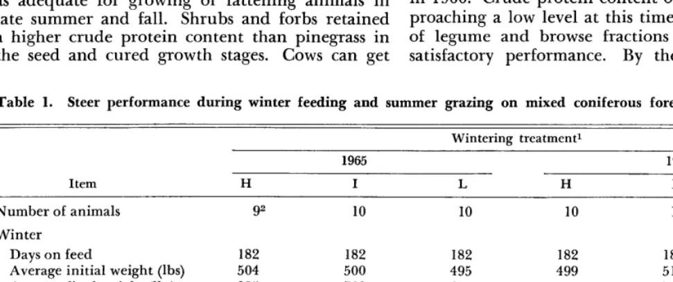
FIG. 1. Average weight of treated tall bluebell plants expressed as a percentage of the average weight of the 12 check plants at the bluebell site.
The total production of all clipped plants was determined each year by adding the air-dry weight of foliage removed, the estimated amount of foliage remaining, and regrowth estimated 2 to 3 weeks after the third clipping date. Total production of the check and “lodge” plants was estimated at the third clipping date.
In 1967, after 4 successive years of clipping, height and stage of development were observed weekly and all plants were allowed to grow to maturity. Production, number of
stems, and average stem height were determined for each plant in late July after seed was shed but before the plants dried. To determine production, half of the plants at each site (two replications) were clipped at ground level and dried. Production of the remaining plants was estimated.
Independent analyses of variance were done for produc- tion, height, and stem number in 1967 with clipping treat- ment and phenological stage at time of clipping as fixed effects in a randomized design. Inclusion of clipped and estimated weights in a single analysis might have introduced some bias but the differences between treatments were so great that the bias probably was minimal.
At the bluebell site, the underground plant crowns and major roots of the clipped plants were excavated. Carbo- hydrate content of the crowns was determined by the acid hydrolysis method.4
Results
Herbage Production
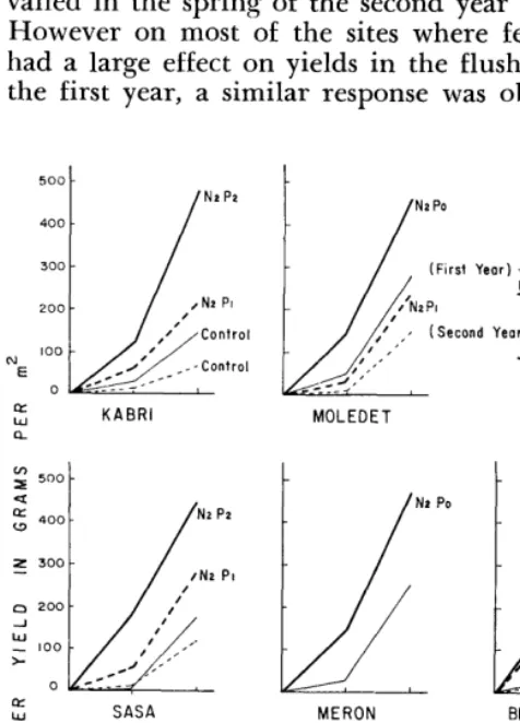
At both sites, herbage production was signifi- cantly5 reduced in 1967, as a result of 4 successive years of clipping (Tables 1 and 2). In most in- stances, foliage removal during the growth stage was less damaging than clipping when plants were flowering and fruiting. For example, at the blue- bell site the plants clipped 100% during the growth stage produced only 18% as much herbage in 1967 as the unclipped check plants in 1967, while those clipped at the flowering and fruiting stages pro- duced only 3 and 5y0 of the check, respectively (Fig. 1).
In 1967, five plants at the bluebell site and one plant at the mixed-forb site were dead. These had been clipped at either 100 or 7070 during the flowering and fruiting stages.
Lodging during the growth stage did not sig- nificantly reduce herbage production because the stems when flattened were merely bent and in a few days they straightened up and grew normally. Lodging during the flowering and fruiting stages significantly lowered herbage production but the reduction was not as great as clipping during the same stages. This could be explained by the fact that the succulent stems (containing 85-90% water) become brittle as they increase in diameter; thus many of them broke when lodged during the flow- ering and fruiting stages.
Number and Average Height of Stems
The 100, 70, and 40% clipping treatments sig- nificantly reduced stem number and height at all three stages (Tables 1 and 2). However, the effect on stem number and height was not so pronounced as the reduced herbage production by the same
4McDonough, Walter T. Carbohydrate reserves in Merten- sia arizonica as related to growth, temperature, and clip- ping treatments. Manuscript in preparation.
TIME AND INTENSITY OF CLIPPING 301
Table 1. Effect on tall bluebell in 1967 after 4 years of clipping treatments.
Bluebell site Mixed-forb site
*vg Stem
Time and dry wt height dry wt *vg Stem
(g) Stems (inch) height
treatment (g) Stems (inch)
Growth stage
None1 1862 92 26 106 54 25
Lodge 256” 122 28 69 48 22
40% 58 53 21 15 20 15
70% 72 53 22 13 20 14
100% 34 38 15 8 15 13
Flowering stage
Lodge 84 62 22 28 42 18
40% 36 41 16 8 19 13
70% 8 21 8 12 16 10
100% 6 12 9 1 3 7
Fruiting stage
Lodge 80 82 18 61 45 24
40% 67 74 18 24 32 18
70% 4 6 6 6 12 14
100% 10 10 7 4 14 10
1 Check plants were not treated.
2 Figures for check plants are averages from 12 plants. 3 Figures for treated plants are averages from four plants.
treatments. For example, on the bluebell site the 100% clipping treatment at the flowering stage re- duced herbage production in 1967 to only 3% of the check in 1967 (Fig. 1). But number of stems and stem height were 13 and 35y0 of check, respec- tively.
Flowering
Reduction in vigor, which was reflected by a reduction in herbage production, number of stems, and stem height, also delayed development and re- duced flower and fruit production in 1967 even though plants were allowed to grow to maturity.
Table 2. Results of multiple range tests comparing the average1 dry weight, number of stems, and stem height of tall bluebell plants at the two study sites in 1967.
Bluebell site Mixed-forb site
*vg Stem *vg Stem
Treatment dry wt (g) Stems (inch) height dry wt (g) Stems height (inch)
None2 3186a 92c 26e 106 54” 25
Lodge 140a 89c 23~ 53 45’1 21
40% clipping 54b 56 18 16s 24i 15k
70% clipping 28h 27” 12f 109 16ij 13kl
100% clipping 17b 20d 10f 4g llj 10’
1 Averages of 12 plants with the same treatment at all three dates.
2 Check plants were not treated.
3 Within each column, means followed by a common letter are not significantly different at the 50/, level as determined by the multiple range test (Duncan, 1955).
Almost all (80 to 100%) of the stems of the check and lodged plants produced flowers and most of these stems produced some fruit. All plants clipped during the growth stage and plants clipped at the 40% level at the flowering and fruiting stages started flowering 1 to 2 weeks later than the check plants in 1967; only 50 to 80% of the stems on these plants produced flowers. Most of the plants clipped at 70 and 100% during the flowering and fruiting stages produced only basal leaves (Fig. 2). The few stems of these plants that did flower did so 2 to 3 weeks later than the check plants.
Relation Between Treatment and Carbohydrate Content The amount of stored carbohydrates was highly significantly correlated (r = +.64, df = 28) with
amount of herbage production in 1967. Whether this degree of correlation is biologically important is not known and further study is needed. Except for those plants clipped at the 100% level, the
LAYCOCK AND CONRAD
Check (Av of all plants)
Growth Flowering Fruiting
STAGE OF DEVELOPMENT
FIG. 3. Carbohydrate content of plant crowns in 196’7 of treated and untreated tall bluebell plants.
plants clipped during the growth stage had the lowest levels of stored carbohydrates (Fig. 3).
The amount of stored carbohydrates at the time of foliage removal may influence the relative dam- age to the plant (Jameson, 1963). A recent study by McDonough” on tall bluebell in the study area indicated that carbohydrate in the crown reaches a low when the plant is in the early- to mid-period of vegetative growth before the start of flowering. Carbohydrate levels then build up slowly until the end of fruiting.
Based on McDonough’s findings, clipping during early growth the first year was done when carbo- hydrates were decreasing, clipping during flower- ing was done when carbohydrates were increasing slightly but were still at a low level, and clipping during fruiting was done when carbohydrate levels had built back to a relatively high point. This would indicate that carbohydrate levels at the time of clipping were not closely correlated with response to clipping because the flowering and fruiting stages were the most damaging to tall blue- bell. However, the treatments had the effect of progressively delaying growth and development compared with unclipped check plants as years of treatment increased. Thus the exact time of clip- ping in relation to the carbohydrate cycle for the clipped plants is not known for the last 2 or 3 years of the study.
Summary and Conclusions
Moderate use (40% clipping) of the bluebell
herbage for 4 consecutive years reduced its poten- tial to produce herbage. However, the plants with 40% of their foliage removed maintained a rela-
G See footnote 4.
tively constant level of production during the last 3 years of the study. It appears that 40% foliage removal by grazing every year would reduce the total productivity of a tall bluebell range but prob- ably would not eliminate tall bluebell from the community. Heavy use (70 to 100% clipping) was much more damaging and actually killed some plants. Consistent heavy use over a long period, especially during flowering and fruiting, probably would severely reduce the amount of tall bluebell on the range or eliminate it entirely.
Trampling or lodging of tall bluebell did little damage to the stems in the growth stage but did far more damage during flowering and fruiting stages. Actual trampling damage by sheep on the range also occurs mainly when plants are mature; thus management plans for tall bluebell ranges should be designed to minimize and allow for such damage as well as the amount of herbage actually eaten by sheep.
Since our study has shown that tall bluebell was affected less by clipping in the growth stage than in the flowering and fruiting stages, the implica- tion is that early grazing would not be as damaging to tall bluebell as is commonly supposed by range managers. Grazing begins June 15 each year on the allotment where our study was conducted and on July 1 on most other sheep allotments in the vicinity. Grazing during the early growth stage (early June in most years) would not be as damag- ing to the plants as grazing in late June or early July each year. However, sheep do not eat a great deal of tall bluebell when they first arrive on the allotment. Instead they eat young, tender grass shoots for a short period and start eating large quantities of tall bluebell when the plants are about half grown (at the beginning of the flower- ing stage). Therefore, early grazing would not nec- essarily insure utilization of tall bluebell at the least damaging stage of growth. Other factors that might lead to excessive soil disturbance, such as high soil moisture, would also have to be con- sidered.
Whether or not early grazing is considered, the best management of ranges containing tall bluebell would include a rotation system of grazing insur- ing use of plants at a different time each year. De-
SAGEBRUSH CONVERSION 303
LITERATURE CITED ranges of Utah, Nevada, southern Idaho, and western DUNCAN, D. B. 1955. Multiple range and multiple F tests. Wyoming. U.S. Forest Serv., Intermountain Forest and
Biometrics 11: l-42. JAMESON, DONALD A. Range Exp. Sta. Res. Paper 32. 1963. Responses of individual plants 17 p. ELLISON, LINCOLN. 1954. Subalpine vegetation of the Wa- to harvesting. Bot. Rev. 29:532-594.
satch Plateau, Utah. Ecol. Monogr. 19:95-121. MATTHEWS, VERL B., AND PAUL W. CONRAD. 1968. An HOLMGREN, ARTHUR H., AND JAMES L. REVEAL. 1966. ecological life history of tall bluebell (Me&n.& arizonica
Checklist of the vascular plants of the Intermountain var. Zeonardii) in IJtah. Ecology 49(6): 1113-l 123, illus. region. U.S. Forest Serv. Res. Paper INT 32. 160 p. U.S. FOREST SERVICE. 1937. Range Plant Handbook. U.S. HOUSTON, WALTER R. 1954. A condition guide for aspen Gov. Print. Off., Wash., D.C., 841 p.
* * %
Sagebrush Conversion to Grassland
as Affected by Precipitation, Soil,
and Cultural Practices19
2L. M. SHOWN, R. F. MILLER, AND F. A. BBANSON Research Hydrologist, Research Hydrologist, and Botanist,
Water Resources Division, Geological Survey, U.S.D.I. Denver, Colorado.
The most wheatgrass.
successful in areas of
Highlight
conversions of sagebrush to the Western United States
crested that re- ceive a”n average of 8 to 14 inches of precipitation annually, usually occur where the annual precipitation exceeds 10 inches and on soils having medium moisture-holding ca- pacities. Conversion results were intermediate on coarse soils having low moisture-holding capacities and compara- tively poor on fine soils having high moisture-holding ca- pacities. Degree of grass establishment varied directly with the big sagebrush vigor-index. Grass production was lower on gravelly sites converted from black sagebrush than on nearby sites converted from big sagebrush. Cheatgrass hin- dered the establishment of crested wheatgrass in some places. Conversion results were poor on sites where grease- wood or shadscale was mixed with sagebrush. These halo- phytes had usually re-established on the treated sites.
Several million acres of sagebrush, principally big sagebrush (Artemisia tridentata), in the West- ern United States have been plowed and seeded in attempts to produce more forage, reduce erosion, and control undesirable plants. Successful seedings have thus resulted in a more beneficial use of the limited precipitation in arid and semiarid regions. Large increases in forage on seeded areas in many cases has allowed improvement of nearby ranges by the reduction or deferment of grazing. Several million additional acres of sagebrush probably will
l Publication authorized by the Director, U.S. Geological Survey.
2This paper is part of a manuscript submitted by the senior author to the Watershed Management Department of the University of Arizona in partial fulfillment of the require- ments for the Master of Science Degree. Received October 12, 1968; accepted for publication January 23, 1969.
be converted to grassland within the next one or two decades.
Other means besides plowing and seeding are sometimes suitable for improving the perennial grass cover of rang-elands. Spraying the sagebrush with 2,4-D to release native grasses is often success- ful. Other practices that may be effective are: (1) reduction or deferment of grazing, (2) changing the class of livestock, or (3) changing the season of use.
Pechanec et al. (1965), Hull and Holmgren (1964), Hull et al. (1962), and Plummer et al. (1955) have all listed climatic, soil and plant- indicator criteria for selecting sagebrush areas suit- able for converting to a perennial grass range. Most of these authors also made recommendations on sagebrush elimination methods, seeding meth- ods, species to seed, and grazing management.
This study conducted in cooperation with the
1J.S.
Bureau of Land Management in 1963 and1964 had two objectives. The main objective was to investigate the effects of annual precipitation, soil properties and cultural practices on crested wheatgrass (Agropyron desertorum) establishment in sagebrush regions of the Western United States that receive an average of 8 to 14 inches of precipi- tation annually. A related objective was to assess several species of sagebrush, occurring alone or mixed with associated shrubs, as indicators of the seeding potential of sites where they occur.
The authors are greatly indebted to R. S. Aro who collected most of the plant data, helped with the interpretation of all the data, and offered sev- eral valuable suggestions on the organization of a preliminary report. The assistance of G. A. Tomp- kins in the field and laboratory is gratefully ac- knowledged. Cooperation of personnel of the Bu- reau of Land Management in providing records and information about the seedings is greatly ap- preciated as is their review of the preliminary report.
Study Areas and Methods
SAGEBRUSH CONVERSION 305
it is the part of the soil that is wetted most fre- quently. In general the surface soils were com- posed of the A and AB horizons and were usually four to eight inches deep.
The data were separated into three MHC groups (Fig. 1) on the basis of the nearly normal frequency distribution having 17y0 of the samples in the low group, 70% of the samples in the medium group, and 13y0 in the high group. Mean moisture con- tent at saturation was 33y0 and the standard de- viation was 8%.
Perennial grass production on the untreated areas was usually very low and for practical pur- poses was considered negligible. Therefore, each crested wheatgrass yield in Fig. 1 represents either an increase or no change in grass production due to the treatment. The three yield ranges overlap considerably because of extreme variability in the yields of the low and medium groups and some poor yields in all groups. The within group vari- ability, in part, is attributed to differences in both average annual precipitation and amounts of pre- cipitation during the periods when the seedings were becoming established. Other sources of vari- ability, which will be discussed later, include dif- ferences in: (a) competition from other species, (b) seeding methods, and (c) soil salinity.
Yield of grass at a particular location varies from year to year with precipitation and growing con- ditions. The precipitation was about average or above average for most sites the year they were sampled, so those yields may be higher than the long-term average. Also, some of the yields may exceed their long-term average because many of the seedings were young, having been planted since 1960. Owing to drought, several of the sites seeded in 1960 and 1961 had rather poor stands of grass. Under proper management these stands may im- prove during favorable moisture years. A notice- able increase in cover of a crested wheatgrass stand was observed between 1963 and 1965 on a seeding near Ely, Nevada, during which time the annual precipitation was two to four inches above normal. The data in Fig. 1 show that highest yields oc- curred on soils with medium moisture-holding properties. These are soils that have an optimum balance among the properties of moisture infiltra- tion, MHC, and moisture availability to plants. The soils of the medium group are sandy loams, loams, or silt loams at the surface, whereas the sub- soils, composed of the B and BC horizons, are usually finer textured. The surface soils are usually loose to moderately hard in dry consistence and have vesicular, platy, or subangular blocky structure, and the subsoils exhibit subangular blocky, angular blocky, or crumb structure. Permeability of soils having these properties is usually good to excel- lent; they normally absorb and hold available to
plants much of the water that results from all pre- cipitation events except those of very high inten- sity. Reynolds and Springfield (1953), after study- ing the results of attempts to convert sagebrush land to crested wheatgrass in New Mexico and Arizona, concluded that, “An ideal soil for maxi- mum herbage production is one at least two feet deep having a well-developed profile of sandy loam surface two to six inches deep underlain by a clay of blocky structure.”
Soils included in the low MHC group are either sandy, extremely gravelly, or cobbly. The per- meability of sandy or gravelly soils is normally ex- cellent. However, coarse-textured soils usually do not have enough particle surface area or enough pores of a sufficiently small diameter to retain an adequate quantity of water in the root zone of crested wheatgrass seedlings to sustain them through periods of low precipitation. Nonethe- less, many sagebrush land soils which have sandy surface layers also have medium-textured subsoils which retain moisture that infiltrates following snowmelt or large rainstorms. If moisture is rela- tively abundant during the seedling stage, allow- ing the establishment of a well-developed root system, then the mature plants can make use of moisture stored in the subsoil. This can account for the fairly productive crested wheatgrass stands sometimes found on soils having sandy surfaces.
Soils in the high MHC group contain more clay than the soils in the medium and low groups. Most of the surface soils are silty clay loams and the sub- soils are either clay loams or clays. These soils are angular blocky or massive in structure and nor- mally are very hard when dry. These properties indicate that these soils cannot admit water as rapidly, and runoff is more likely to occur from them than from the soils of the other groups. Be- cause of the high moisture-holding capacities of these soils, much of the moisture is retained near the soil surface where it is quite vulnerable to evaporation. Particle contact is much greater in fine-textured soils than in coarser soils resulting in greater movement of moisture upward during the drying phase in response to moisture tension gradients. This may increase the amount of water lost by evaporation. Also, fine-textured soils have more particle surface area and a given quantity of water is retained in thinner films at higher ten- sions, thus less moisture is readily available for uptake by plants.
Site Groups
306
SHOWN ET AL.Table 1. Characteristics of sagebrush-seeding site groups.
Group
Crestedl’
Bigl-/ Estimated Moisture Soil profile meanNo. annual content at Electrical Root penetration
of wheatgrass sagebrush
yield vigor- precipi- saturation conductivity
of herbaceous sites
(lb/acre) index tation (percent) (mmhos/cm
PH species
(inches) Surface Subsoil at 25°C) (inches)
Successful 10 2,290 65 14 41 54 1.52 7.8 31
1,535 41 12 32 38 088 7.0 20
1,010 24 11 20 21 .58 6.2 16
Moderately 16 812 72 14 48 50 3.11 7.5 28
successful 386 37 10 31 32 .88 7.1 19
132 . 14 8 17 23 .33 6.7 12
Cheatgrass 7 744 53 11 51 66 1.74 7.0 31
competition 297 40 11 40 51 1.14 6.6 23
46 20 11 28 31 .68 6.3 16
Halophyte 8 608 37 14 42 46 5.16 8.1 28
124 26 11 30 32 1.94 7.6 14
0 16 9 22 24 .59 7.4 12
Failure 7 tr 55 11 44 49 1.06 7.7 20
0 28 9 32 36 .72 7.3 16
0 5 8 23 20 .39 6.9 12
Mean for all sites
48 505 35 11 33 36 1.07 7.1 19
1/ The top number in each cluster is the high value, the middle number is the mean, and the bottom number is the low value for the group.
L/ The big sagebrush vigor-index was obtained by multiplying the average height in feet by the percent cover.
The soils and root data shown are for the treated sites; the data were similar for the untreated sites.
Precipitation
effectsThe data in Table 1 show a general relationship between annual precipitation and crested wheat- grass establishment as reflected by the grass yields. The highest yields occurred in the group which had the largest precipitation mean, 12 inches. The group of sites where no grass was established had the smallest precipitation mean, 9 inches. The average crested wheatgrass yields of the cheatgrass competition group and the halophyte group in Table 1 do not correlate with the average precipi- tation values for these groups because of competi- tion and salinity factors respectively. These results agree, in general, with the findings of several other workers who have studied the seeding of crested wheatgrass in the sagebrush type. Plummer et al. (1955) reported that rangeland seedings in the In- termountain region could be successful, as a general rule, where average annual precipitation exceeds
10 inches. According to Hull et al. (1962), seedings have not been successful on areas in Colorado hav- ing less than 10 inches of annual precipitation. Reynolds and Springfield (1953) found that most of the crested wheatgrass plantings in big sagebrush areas of Arizona and New Mexico receiving less than 12 inches of annual precipitation had been failures.
Favorable distribution of precipitation, moder- ate temperatures, and permeable soils that readily release moisture to the plants have resulted in the establishment of fair stands of crested wheatgrass in areas where the annual precipitation is only about 8 inches. Five such sites are included in the moderately successful group of Table 1. This corrobates the findings of Plummer et al. (1955), that, “With careful planting in soils having good moisture-holding qualities, successful stands have been attained where annual precipitation is as low as 8 inches.” Regardless of the average annual precipitation, it appears that favorable moisture conditions are essential the first one or two years after seeding to establish vigorous plants with well- developed root systems; after establishment crested wheatgrass can survive rather severe drought.
Big sagebrush
vigor
308 SHOWN
The crested wheatgrass yields for these four sites averaged about 360 lb/acre in 1964; production is probably limited td about that level by the adverse moisture-absorbing and moisture-holding properties of the fine-textured soils. The soil at another site is sandy; when saturated, the average moisture content of its root zone is 26%. The low grass production of that site, 132 lb/acre in 1964, is apparently due to the low MHC of the soil and to the lack of sufficient precipitation.
The black sagebrush sites are on gravelly terrace and fan deposits. Small gravel forms a pavement on the surface and occurs in the surface soil. In general, the gravel increases in size and quantity with depth; at 12 to 16 inches gravel constitutes at least 50% of the lower root-zone and the rock content is even greater below that. The MHC of the surface soils averaged 3 1.6% and the MHC of the subsoils averaged 25.457,. Grass root penetra- tion averaged 14.5 inches for these sites as com- pared to an average of 18 inches for all of the sites converted from big sagebrush. Miller and Bunger (1963) and earlier workers have shown that a coarse sand or gravel layer underlying a uniform soil im- pedes water movement, because of a reduction in particle contact and surface area, and causes more moisture to be retained in the soil above the coarse layer. This may be a disadvantage because water held in the surface soil is quite vulnerable to evaporation, and may explain why the black sage- brush sites appear to be drier than nearby big sage- brush sites.
Crested wheatgrass production averaged 500 lb/ acre on the three sites converted from black sage and 1,550 lb/acre on three other sites on the same seedings converted from vigorous big sagebrush. These results are not in agreement with the report of Plummer et al. (1955) that adjacent big sage- brush and black sagebrush ranges in Nevada and central Utah yielded similar amounts of crested wheatgrass.
On two sites of this group, competition from big sagebrush appeared to be severe enough to prevent high grass production. One of these sites had been plowed and seeded 8 years prior to investiga- tion. The aerial cover of the reinvaded sagebrush amounted to 40% of the cover on the adjacent un- treated site. Other undesirable features of this site were a root zone that contained about 35y0 gravel by volume and a basalt bedrock at 12 inches, re- sulting in a low MHC. At the other site, which had been treated about one year before examina- tion, the cover of big sagebrush was about 30% of that on the untreated. Although the grass stand probably was not completely established, its growth and production was undoubtedly being hindered by the sagebrush competition.
ET AL.
Cheatgrass competition group
The cheatgrass competition group is composed of seven sites where generally poor stands of crested wheatgrass were mixed with cheatgrass and usually Sandberg bluegrass. In 1963, the cheatgrass pro- duction ranged from 184 to 988 lb/acre on these sites and the mean was 648 lb while the crested wheatgrass mean was 297 lb. Sandberg bluegrass yield varied from 0 to 594 lb/acre having a mean of 292 lb. The amount of cheatgrass present dur- ing the seedling stage of the crested wheatgrass was not kown, but apparently competition was great enough to prevent the establishment of full stands of crested wheatgrass on all of the sites.
Five sites in this group were on the same seeding and were within a few hundred yards of each other. Low sagebrush (Artemisia arbuscula) was the only shrub species on two of the adjacent untreated sites and was mixed with antelope bitterbrush (Purshia tridentata) on a third site. The other two sites had quite vigorous big sagebrush next to them. Mois- ture contents of the saturated soils indicated that the soils were finer textured than optimum for establishing created wheatgrass (Table l), but the abundance of cheatgrass and Sandberg bluegrass, both on the seeding and as understory on the un- treated sites, is indicative of a high grass produc- tion potential.
The remaining two sites of this group were lo- cated on two other seedings. Big sagebrush at one of the sites was moderately vigorous and a fairly dense understory of cheatgrass was present the year of sampling. Natural vegetation at the other site was a mixture of big sagebrush, rubber rabbitbrush (Chrysothamnus nauseosus), and spiny hopsage (Grayia spinosa) and a moderately dense understory of cheatgrass. At other sites on these same two seedings, where there was no cheatgrass competi- tion, crested wheatgrass production was approxi- mately 3-fold greater than on the above-mentioned sites.
310 SHOWN
FIG. 5. Only a trace of crested wheatgrass resulted from the plowing and seeding of this site nea; Ely, Nevada.
sagebrush lacks vigor, and the subsoil is gravelly. The big
trol on plots in Idaho made saline to a level similar to the mean salinity of the halophyte group soils.
This study shows that it is difficult to convert to grasslands where the vegetation includes grease- wood or shadscale. Hull (1963) conducted seeding trials at several locations in Wyoming where Nut- tall saltbush occurred alone or mixed with other shrubs including big sagebrush and shadscale. After 11 to 14 years, crested wheatgrass and Russian Wildrye (Elymus junceus) stands had deteriorated until they were poor or gone. If treatment of halo- phyte lands is necessary, arcadia-type contour fur- rowing and seeding as discussed by Branson et al. (1966) may be effective.
Failure grouf~
The failure group consists of eight big sagebrush sites where crested wheatgrass failed to become established (Fig. 5). The vigor-index of big sage- brush for this group was next to the lowest of all groups. The structure of the subsoils and the pene- tration of the roots of the annuals on these sites indicate that there is less soil moisture available for plant growth than on most of the other sites in the study.
The relatively low mean value for the estimated annual precipitation partially explains the defi- ciency of soil moisture on these sites. At most of these sites, the soils are deep enough and have the proper chemical and physical characteristics to support vigorous, productive stands of grass if precipitation and the resultant soil moisture were less limited.
Four of the sites are on seedings where the annual precipitation is about 8 to 9 inches. The soils on two of these sites, one of which is shown in Fig. 5, have low moisture holding capacities; possibly there was insufficient moisture held in the surface soil at the right time to promote grass
ET AL.
establishment. On another site, the surface soil has a moisture content at saturation of 35.4%. Considering the very limited moisture conditions, the soil may be of fine enough texture to prevent the survival of grass seedlings. A silty crust about two inches thick existed at the soil surface and this may hamper infiltration of water. One site is lo- cated on an alluvial fan that had a dense cover of annual mustard, both on the treated area and as an understory species on the untreated area. If the mustard was there during the seedling stage of the grass, the competition for moisture was probably detrimental to the grass. A good stand of grass exists on the part of the seeding not on the mustard- covered fan.
The soils at two other sites were medium- textured but had quite high moisture contents at saturation. In consideration of these soil proper- ties, annual precipitation of 11 inches probably does not result in enough available soil-moisture for strong plant growth. However, one of these sites is located on a stock driveway and grazing during the seedling stage may have contributed to the failure.
Type of seeding equipment may have contrib- uted to the poor results of the sites in this group and a few sites in other groups. Two sites that had been broadcast seeded were failures. On the same seeding, two other sites that had been drilled were moderately successful. Information was not always available as to the type of furrow-openers used on the drills, however, it appeared that deep-furrow openers had not been used on the seedings in this group. A study by McGinnies (1959) confirmed that where moisture is limited the best stands of grass were obtained by using drills equipped with deep-furrow openers. Several writers have, none- theless, cautioned that deep-furrow openers should not be used where soils are likely to slough or blow, thus covering the seed too deep.
Loose seedbeds, which allowed the seed to be planted either or both too deep or in poorer con- tact with the soil, were sometimes mentioned by Bureau of Land Management personnel as a prob- able cause of failure at some of the sites. Hull et al. (1962), and Plummer et al. (1955), emphasized that on loose or rough seedbeds, drills should be equipped with depth bands and packer wheels.
LITERATURE CITED
BRANSON, F. A., R. F. MILLER, AND I. S. MCQUEEN. 1966. Contour furrowing, pitting, and ripping on rangelands of the western United States. J. Range Manage. 19:182- 190.
PARAGUAY 311
HAAS, R. H., M. L. HOWARD, AND P. J. TORELZ. 1962. MILLER, D. E., AND W. C. BUNGER. 1963. Moisture reten- Influence of soil salinity and 2,4-D treatments on estab- tion by soil with coarse layers in the profile. Soil Sci. lishment of desert wheatgrass and control of halogeton Sot. Amer. Proc. 27:586-589.
and other annual weeds. J. Range Manage. 15:205-210. PECHANEC, J. F., A. P. PLUMMER, J. H. ROBERTSON, AND HULL, A. C., JR. 1963. Seeding salt-desert shrub ranges in A. C. HULL, JR. 1965. Sagebrush control on rangelands.
western Wyoming. J. Range Manage. 16:253-258. U.S. Dep. Agr. Handbook 277. 40 p.
HULL, A. C., JR., D. F. HERVEY, C. W. DORAN, AND W. J. PLUMMER, A. P., A. C. HULL, JR., GEORGE STEWART, AND MCGINNIES. 1962. Seeding Colorado range lands. Colo. J. H. ROBERTSON. 1955. Seeding rangelands in Utah, Agr. Exp. Sta. Bull. 498-S. 46 p. Nevada, southern Idaho, and western Wyoming. U.S. HULL, A. C., JR., AND R. C. HOLMGREN. 1964. Seeding Dep. Agr. Handbook 71. 73 p.
southern Idaho rangelands. U.S. Forest Serv. Res. Paper REYNOLDS, H. G., AND H. W. SPRINGFIELD. 1953. Reseed-
INT-10. 32 p. ing southwestern rangelands with crested wheatgrass.
KLEMMEDSON, J. O., AND J. G. S~~ITH. 1964. Cheatgrass U.S. Dep. Agr. Farmers Bull. 2056. 20 p.
(Bromus tectorum L.). Bot. Rev. 30:226-262. RICHARDS, L. A. (ed.). 1954. Diagnosis and improvement MCGINNIES, W. J. 1959. Relationship of furrow depth to of saline and alkali soils. U.S. Dep. Agr. Handbook 60. 160 p.
moisture content of soil and to seedling establishment U.S. SOIL SURVEY STAFF. 1951. Soil survey manual. U.S. on a range soil. Agron. J. 51:13-14. Dep. Agr. Handbook 18. 503 p.
Range and
RUBEN A. Profesor, Facultad
Livestock Characteristics
of Paraguay
FRETES AND DON D. DWYER de Agronomia y Veterinaria, San Lorenzo, Paraguay, and Professor of Range Management,
New Mexico State University, Las Cruces, New Mexico
Highlight
Paraguay, located in the central part of South America, has an area of 157,000 square miles (40.7 million hectares). The country is divided into two geographic-physiographic areas: the eastern area with 40 percent of the land and relatively high precipitation; and the western or Chaco region with 60 percent of the land area and a semi-arid type climate. The economy of the country is based pri- marily on livestock and forest products. The efficiency of beef production in Paraguay is lower than in many other countries because improved management techniques are still being developed. The rangelands have a high potential for forage production, but many are overgrazed and sub- jected to improper burning. In general, the future of the ranching enterprise in Paraguay is bright. With added technical assistance and more and better trained Para- guayans, Paraguay has the potential of becoming a leading agricultural nation in South America.
Algunas Caracteristicas de las Praderas y de1 Ganado de1 Paraguay
Rusumen
Paraguay, localizado en la parte central de America de1 Sur tiene una superficie de 400,000 kilometros cuadrados. El pais se divide en dos unidades geograficas-fisiograficas; (1) la Region Oriental, con una superficie que abarca el 40% de las tierras de1 pais, con topografia ondulada y buenas precipitaciones durante el ano y (2) la Region Oc- cidental, o Chaco, que ocupa el 60% de las tierras, con una topografia plana y un clima semiarido. La economia de1
pais esta basada en la agricultura, ganaderia y production forestal. La ganaderia, de la cual la explotacion de bovinos es la mas importante, posee el potential necesario para una mayor expansion y desarrollo.
Paraguay is one of the smaller countries of South America. It is roughly the size of California with an area of 157,000 square miles (40.7 million hec- tares). It is located in the central part of South America between latitudes 19’S and 28’S, and lon- gitudes 54”W and 63”W. Paraguay is an inland country surrounded by Argentina, Brazil, and Bo- livia and depends on the Paraguay and Parana rivers for access to the Atlantic Ocean. The coun- try is divided by the Paraguay river into two geographic-physiographic areas: the rolling, humid eastern region with 40y0 of the land, where most of the population is concentrated, and the semi- arid alluvial western region, or Chaco, with 60% of the land area.
The population of the country is about Z,OOO,OOO, of which 63.5% is rural. The mean population density is 5 persons per square kilometer, ranging from 67 in the eastern region to 0.4 in the western region.
The economy of the country is based on produc- tion of tropical and sub-tropical crops and products of the natural forests and grazing lands. The coun- try has few mineral resources and little industrial development.
General Environment
The eastern region is undulating to rolling with elevations ranging from 50 meters above sea level to 830 meters in the hills. The Chaco region is mainly flat and with an average elevation of 400 feet.
312 FRETES AND DWYER
Table 1. Number of livestock by species in Paraguay.1
Species Number
Cattle2 Beef Dairy Horses Sheep Goats
4,815,OOO 646,000 673,000 438,000 48,000 1 Data from “Secretaria Tecnia de Planificacion.”
2Principal beef breeds are native Criollo, Zebu, Zebu crosses and Hereford; dairy breeds are Holstein, Native and crosses.
rhythm during the year. The summer months (September-March) are hot and humid and the winter months (April-August) are cool and dry with some frosts. The mean annual temperature is 22.5C (72.51;) ranging from 26C (78.8F) in the northwest to 21C (69.8F) in the south and east. The mean annual precipitation ranges from 500 mm (20 inches) in the northwestern part to 1,700 mm (68 inches) in the south with about 1,350 mm (56 inches) at the capital city of Asuncion.
The main great soil groups are Ultisols (Red Yellow Podzolic) developed from granite, porphyr, sandstones and shales; Ultisols (Reddish-Brown Lateritic) soils derived from basalt, and Vertisols (Grumusols) derived from limestones and shales (Food and Agricultural Organization, 1964). Al- luvial soils such as Ultisols (Planosols), Inceptisols (Humic Gleys), Aridisols (Solonetzs), and Mollisols (Chestnuts) occupy the lowlands. The soils of the eastern region, with the exception of the Vertisols, are low in fertility and especially in available phos- phorus and exchangeable calcium. The alluvial soils of the Chaco are high in salt and alkali in some areas. They have fair fertility but generally poor physical characteristics.
Cattle Production
Cattle are the animal species most utilized in Paraguay and beef is the dominant type of pro- duction (Table 1). The cattle enterprise is oper- ated privately by individuals or companies. Four types of cattle operations can be found: cow-calf, steer production, mixed and fattening.
The principal beef breeds are the native Criollo, Zebu, Hereford, Santa Gertrudis, and their crosses. Herefords are predominant in the Chaco, which has 40y0 of the cattle. In the eastern region, which has 60’7, of the cattle, native Criollo, Zebu, and various crosses predominate. Among dairy animals, Holstein cows, native Criollo, and their crosses are mostly used. The dairy herds are found near the larger cities. Sheep and goats are kept on most ranches for food. Chickens are also commonly used for meat. There is very little refrigeration and
Table 2. Production characteristics of beef cattle in Paraguay.l
Average Final Sale Weight 348 k (767 lb)
Net Yield per Animal 170 k (374 lb)
Time to Final Weight 3-5 years
Percent Calf Crop 30-400/o
Average Annual Mortality 6.1%
1 Data from “Secretaria Tecnia de Planificacion.”
these small animals are easily consumed before spoilage.
The efficiency of beef production is lower in Paraguay than in many other countries (Table 2). The principal reasons are generally too severe grazing, lack of or deficient supplemental feeding during critical seasons, inadequate watering and fencing, insufficient control of animal parasites, pests and diseases, and transportation and market- ing problems. Cattle in Paraguay are grown and finished on the range with little or no supple- mental feed.
Rangeland Characteristics
The principal natural plant formations of the country include: broadleaf evergreen forest, semi- deciduous forest, parkland, palm savanna, grass- land, dry forest and swampland vegetation (Fretes, 1967). Climatic and edaphic factors are the con- trolling influences of this wide variation of vege- tation types.
Forty percent of the total surface area is grazing lands (Table 3). Plant formations of grazing value include the grassland, parkland, savanna swamp- lands, and parts of the dry forest (Fig. 1). Approxi- mately 30yo of these grazing lands is seasonally covered by flooding waters, 30yo is subject to light to severe invasion by undesirable plants such as species of Proso+, and 25y0 has agricultural po- tential for subtropical corps or improved forage species. Only 1 y. of the 16.2 million hectares of grazing lands is used as tame pasture. Nearly 71 percent is native range and grazed year round while 28 percent is native but grazed seasonally. Table 4 summarizes the principal grassland types and their main characteristics and Figure 1 shows the dis- tribution of these grassland types. The grass family
Table 3. Current land use in Paraguay.1
Land use Hectares
Cultivation 1,627,OOO
Grazing Lands 16,270,OOO
Forest Lands 2 1,964,OOO
Non-agricultural Lands 813,000
Total 40,674,OOO
1 Data from “Secretaria Tecnia de Planificacion.”