EA
Abstr simu Prade by tw comm comm auton effec avail Keyw In th it is the e majo few Him cons It w eart with to th in t 9,00 epic hypo This hesi disa earth Indi distr 1905 than build Dha is shARTHQU
REGIO
University I Hiract : We pres lation tool for w esh state with a wo independent mercial Internet mercial commu nomously powe ctively react wit
able in the west
words: Early Ea
he era of adv still a big c earthquake.N or concern o
geographic malayan regio
siderably vul
was a harsh tr thquake (als h a magnitud he northwest the Himalay 00 people an centre was e
ocentre was s earthquake tant to stay i ster to strik hquake. Earl
a faced anot rict in the s 5, with a ma n 20,000 peo
dings in th aramshala an
hown in Figu
Interna
UAKE EA
ON OF IN
Dhirendra
Institute of In imachal Prade Shimla 171ent a Long dis wireless links d a ring topology t routes, a dire t, it is not affec unications netw ered by means
th the proper m
tern Himalayan arthquake Warn 1. INTROD vancement in challenge to Natural Disas f all human b
locations in on of India
lnerable to ea
ruth to witne so known as de of 7.8M at t of Kathman yan Region,
nd injured m east of the d
at a depth e created gre
in their home ke Nepal sinc lier, the wes
ther, still wo tate of Hima agnitude 7.8 ople and caus
[image:1.595.315.560.447.684.2]he cities d Palampur ure 1.
Volu
ational Jou
Av
ARLY WA
NDIA: AN
a Sharma
nformation Tec esh University 005, India The Abdusstance Wi-Fi b design. In this p is proposed. T ect one and an cted by comme works, as often of solar panels measures. The f n Region of Ind
ning System (EE
DUCTION
n Science an have a fore ster due to e beings aroun n Himachal
are under Se arthquakes.
ess 25th Apr the Gorkha t about a dist
ndu, the cap which kill more than 2 district of La of approxim eat panic an
es. It was the ce the 1934 stern Himala orse, earthqu achal Prades 8 M, which
sed terrible of Kangra, [2].The deva
ume 9, No.
urnal of Ad
RESE
vailable On
ARNING
N ARCHIT
SIMUL
chnology, y,Erma
ICT for D s Salam Intern StradaCostieased architectu aper, a dedicate This topology al
other using an ercial traffic du n happens after and batteries. T
functional archi dia constituting
EWS), Long dis
nd Technolog ewarning abo arthquake is nd the globe.
in the weste eismic zone
ril 2015 Nep a earthquak tance of 80 k pital of Nep led more th 25,000 [1]. amjung and
mately 15 km d people we e worst natur 4 Nepal-Bih ayan Region ake in Kang sh, on 4th Ap h killed mo destruction , Mcleodga astation caus
1, January
dvanced Re
EARCH PA
nline at ww
G SYSTEM
TECTUR
LATION
anno Pietros
Development Lnational Centr era 11 34014,
ural design for ed bidirectional llows for redund n intermediate s
uring and after r a seismic ev Therefore, the
itectural design a major step to
stance WiFi, Bo
gy, out a A ern V, pal ke) km pal, han Its its m. ere ral har of gra pril ore of nj, sed Th M da an 25
y-February
esearch in C
APER
ww.ijarcs.in
M IN TH
RAL DES
TOOL
IC The Abdus Physics,semoli
Laboratory, re of TheoreticTrieste, Italy
an early earthq l communicatio dancy to transp site as a repeat an earthquake. ent, the propo seismic data w
n testbed for ea
improve earthq
otRf, Radio link
Figure 1.
he Nepal ea Mount Everes
ay killing a nother huge 50 people w
y 2018
Computer
nfo
HE WEST
SIGN USI
Marco
CT for Develo Salam Interna StradaCostiercal Physics,
quake warning on ring connecti port the signal to
ter point. Bein . Even in case sed network w will be delivered
arly earthquake
quake monitorin
k simulation, Li
Market after (Kangra D
arthquake als st making A at least 19 p avalanche in were reported
Science
ISSN N
TERN HIM
ING THE
o Zennaro
opment Laborational Centre ra 11 34014, T
system using ing three locati o the earthquak ng a dedicated of disrupted se would still oper d to the emerg
warning (EEW
ng alertness in t
ine of Sight (L
r earthquake Distt.), India
so triggered April 25, 20 people. It fu n the Langtan d missing. In
No. 0976-56
MALAYA
E BotRf
atory, e of Theoretica Trieste, Italy
the BotRf Tele ons within Him ke monitoring c
ring, not part ervice of the ex
rate since it w ency offices th
W) system wou
this region.
LOS)
e in Palampur .
an avalanch 015 the dead
urther trigg ng valley, w n the past, t
697
AN
al egram machal entres of the xisting will be hat canuld be
had been many other instances of earthquakes in India, with many lives lost. These tremors were also felt throughout India, from north to down south in Kerala; Bhutan, Bangladesh and Pakistan [3], details given below:
Human Life is extremely precious, which demands an efficient & prompt Early Earthquake Warning Systems (EEWS) in each of the highly sensitive seismic zones with minimum delay. Thismotivated the present study aimed at building areliable early warning infrastructure at long distances. If high-intensity earthquake hits Himachal Pradesh state, it might disrupt the traditional communications lines and road, bridges and cables might be washed away. In this scenario, the only source of communications would be dedicated radio links, since mobile phone, internet and other cabled media may not work, according to [4]. Traditionally, Wireless Sensor Networks(WSN)have beensuccessful deployed indoor for distances upto 30 metres, and outdoors setting up to a couple of kilometres. Nevertheless, using high gain antennas and modified protocolos very long distances and high throughput can be achieved with modified WiFi low cost equipment.The longest WiFi link on recordwas established by Ermanno Pietrosemoli(one of the author of this paper) over a 382 km path in 2006 [5], [6].By cascading several links in a row the Rural Telecommunication Research Group of Pontificia Universidad Catolica del Peru (GTR PUCP) in collaboration with the Spanish EHAS Foundation,was able to span 445 km in the Amazonian jungle [7] to service rural communities along the Napo river. However, as far as we know, this kind of long distance
communication has not been utilized for early earthquake warning and monitoring systems.
In this paper, an effort has been made to design an EEWS as a pilot project for the western Himalayan Region of Indiausing long distance WiFi links. This would be helpful for sending an early alert triggered by sensors when seismic waves are generated by an earthquake. Such an advance warning system could allow people to take appropriate actions to protect their lives.
A demonstration EEW System [8] called ShakeAlert began sending test notifications to selected users in California in January 2012. The system detects earthquakes using the California Integrated Seismic Network (CISN), an existing network of about 400 high-quality ground motion sensors. CISN is a partnership between the United States Geological Survey (USGS), State of California, Caltech, and University of California at Berkeley, and is one of the seven regional networks that make up the Advanced National Seismic System (ANSS).
ShakeAlert is transitioning from the current demonstration system to a production prototype for the West Coast. The USGS has published an Implementation Plan with the steps needed to complete the system and begin issuing public alerts. The basics are schematically presented in Fig.2.
Figure 2.
on the surface of the earth. Propagation velocity ratio of these two waves is roughly 2:1.
Earthquake early warning systems, like ShakeAlert, work because the warning message can be transmitted almost instantaneously, whereas the shaking waves from the earthquake travel through the shallow layers of the Earth at speeds of about one to a few kilometers per second (0.5 to 3 miles per second) [10]. This diagram shows how the system would function. When an earthquake occurs, both compressional (P) waves and transverse (S) waves radiate outward from the epicenter. The P wave, which travels fastest, trips sensors placed in the landscape, causing alert signals to be sent ahead, giving people and automated electronic systems some time (seconds to minutes) to take precautionary actions before damage can begin with the arrival of the slower but stronger S waves and later-arriving surface waves. Computers and mobile phones receiving the alert message would be able to calculate the expected arrival time and intensity of shaking at your location if time permits. Main idea behind is to provide an early alarm system so that people can go out of buildings and save their life.
2. METHODOLOGY:
2.1. The methodology consists of the following steps:
• Identification of sites in the highly sensitive seismic zone (V): For this pilot, three sites weretargeted namely Dharamshala (H.P.), Kufri (Shimla) and Kasuali. These sites fall within the province of Himachal Pradesh, India. It is pertinent to the mention that Shimla (capital of Himachal Pradesh) and Dharamshala (second winter capital of the state of Himachal Pradesh) have been identified as Smart Cities by the Government of India. Therefore, it is expected that funds would be available for innovative ideas/projects in them. The coordinates of the sites are given in table I.
Table-1: Sites for Radio Links
Site Name Latitude Longitude
Antenna Height
Altitude
Dharamshala (DS)
32.287100 76.393886
3 m 4531m
Kufri 31.096454 77.262646
3 m 2675m
Kasauli 30.901792 76.961881
3 m 1841m
• Setting up of Earthquake Monitoring Station (EMS): Seismic sensors installed in vulnerable areas will convey data by means of a dedicated wireless sensor network (WSN). Earthquake Monitoring Station would be installed at Dharamshala and Shimla. Kasauli will act as a relay centre for redundancy thus providing added reliability.
• Communication of earthquake event: As soon as the P wave is detected by the seismic sensor this information is transferred to the earthquake monitoring station (EMS)in less than 1 ms, the time it takes for the radio waveto travel 300 km. When the servers at EMS receive the warning, they set up an alarm system without human intervention. This alarm will be spread by different media to all interested parties.
• Warning Signal: A high volume siren will also be
actuated. (During the mock drill the purpose of the siren will be explained). Efforts will be made to sign a memorandum of understanding (MOU) with all operators and the Government of Himachal Pradesh, to make it possible that every mobile phone in the area will receive an earthquake alert.The purpose of using a long distance modified WiFi is to have an independent, low latency transmission system which is reliable, robust and remotely managed. This allows to launch an early warning system that can contribute to the safety human lives.
2.2. Radio Links planning using the BotRfTelegramtool.
exchanged. Servers are distributed in many locations around the world.
Giving the calc command with the names and coordinates of the extreme to BotRfwill result in a profile of the intervening terrain and a graph of of the radio wave propagating above it at the chosen frequency. The program will warn of any obstacle that intrudes in the Fresnel zone.To calculate the received power strength the radio and antenna parameters must also be entered. For our design we chose the following values:
Operating frequency: 5.8 GHz
Transmision Power: 20 dBm
Receiver Sensitivity: -80 dBm
Antenna Gain: 34 dBi (same antenna used for transmission and reception)
For example, to simulate the link from Dharamshala to Kufri using BotRf we entered: calc ds kufri
Then figure 3(a) was displayed. In it one can see the apparent trajectory of the radio wave and the first Fresnel zone in magenta, the profile of the terrain in green and the apparent earth curvature in brown. We say apparent because the radio wave in reality follows a curve, but by modifying the radio of curvature of the earth according with the atmospheric refraction index we can depict the radio trajectory as a straight line. Its apparent that no obstacle intrude in the Fresnel zone over this 156 km path.
Figure 3 (a)Dharamshala (DS) to Kufri
To calculate the margin of the received signal above the receiver sensitivity we use the command:
pow Site1 Site2 TxPw TxCl TxAg RxAg RxCl RxSe
where:
TxPw: transmitter power (dBm) TxCl: transmitter cable loss (dB) TxAg: transmitter Antenna gain (dBi) RxAg: receiver Antenna gain (dBi) RxCl: receiver cable loss (dB) RxSe: Receiver sensitivity
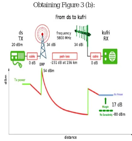
Obtaining Figure 3 (b):
[image:4.595.320.562.65.265.2] [image:4.595.333.552.518.752.2]In this diagram we can see that at the frequency of 5800 MHz the received signal will have a margin of 17 dB above the receiver sensitivity of -80 dBm.This means that the received signal has a value of -63 dBm after traversing the 156 km that separate Dharamsala from Kufri.
Further details of the link can be obtained using the r command:
Results
Path Analysis from ds to kufri
---
Distance between ds and kufri: 155.84 km Transmitter site: ds
Site location: (+32.2871,+76.3939) (+32 17'13"/+76 23'37")
Elevation: 4531 m above sea level
Antenna height: 3 m above ground / 4534 m above sea level
Azimuth to kufri: 147.94 degrees
Depression angle to kufri: -1.2049 degrees Receiver site: kufri
Site location: (+31.0965,+77.2626) (+31 5'47"/+77 15'45")
Elevation: 2675 m above sea level
Antenna height: 3 m above ground / 2678 m above sea level
Azimuth to ds: 328.39 degrees
Elevation angle to ds: +0.1543 degrees
Elevation angle to the first obstruction: +0.1548 degrees
Analysis model: Longley-Rice Parameters used in this analysis: Earth's Dielectric Constant: 15.000
Earth's Conductivity: 0.005 Siemens/meter
Atmospheric Bending Constant (N-units): 301.000 ppm
Frequency: 5800 MHz
Radio Climate: 5 (Continental Temperate) Polarization: 0 (Horizontal)
Fraction of Situations: 50.0% Fraction of Time: 50.0%
Summary for the link between ds and kufri: Free space path loss: 151.59 dB
Longley-Rice path loss: 151.41 dB
Attenuation due to terrain shielding: -0.18 dB
Mode of propagation: Line-Of-Sight Mode Longley-Rice model error code: 0
ErrorMessage[0]: "No error"
No obstructions to LOS path due to terrain were detected.
Following the same procedure we obtained Figure 3(c) for the link from Dharamsala to Kasauli:
Figure 3 (c)Link 2- Dharamshala to Kasauli
Again, there are no obstales in this trajectory.
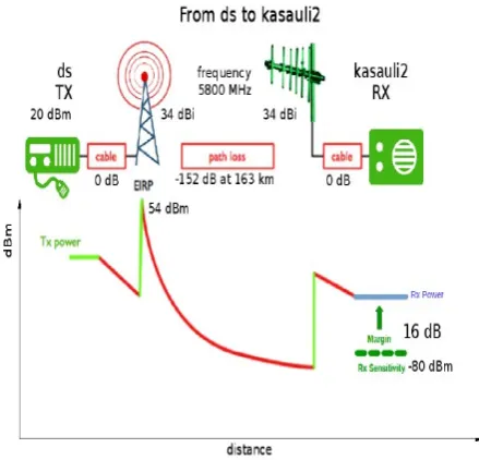
Using the pow command we get Figure 3 (d):
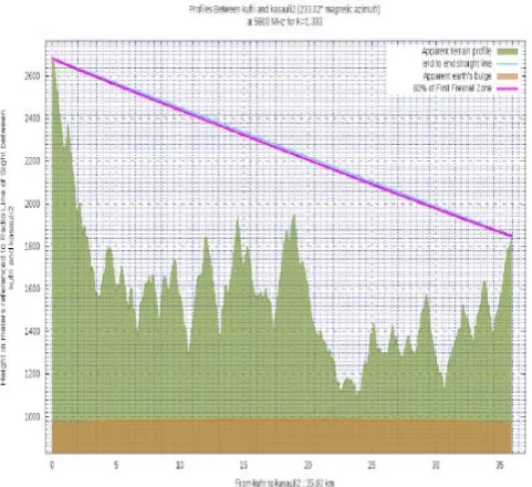
[image:5.595.314.558.214.426.2] [image:5.595.328.548.529.740.2]Which shows that the margin is very similar since there are no obstructions and the path loss is similar. The third link between Kufri and Shimla is shown in Figure 3 (e), again no obstructions encountered, but the margin, depicted in Figure 3(f) is now 29 dB since the distance is only 36 km.
Figure 3 (e)Link 3. Kufri Shimla to Kasauli
Figure 3 (f)Power vs distance on the Kufri- Kasauli link
These margins of 17,16 and 29 dB provide a quite reliable signal that will supportthe highest modulation
schemes, affording transmission speeds in the megabit per second range.
Robustness
[image:6.595.43.284.146.366.2]Because of the geographic locations of major earthquake (faults) in Himachal, falling under zone V, the area of interest is vulnerable to seismic activity. For this reason we have envisioned a ring topology, which provides an alternate path to reach the destination in case of failure of one link. This is shown inFigure 4.
Figure 4: Ring Topology between selected sites
Seismic Sensors and its connectivity with Radio
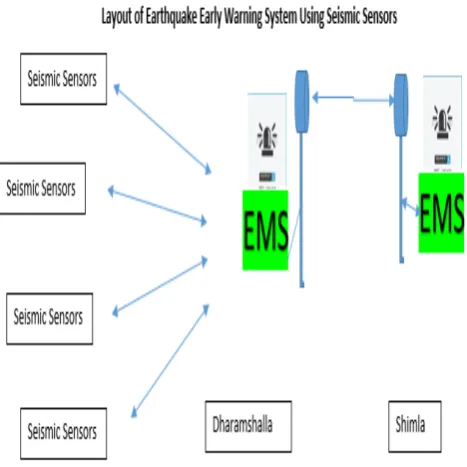
[image:6.595.333.573.237.422.2] [image:6.595.48.275.396.686.2]Figure 5 Layout of EEWS Using Seismic Sensors
Earthquake Monitoring System (EMS) will first sense P wave received from more than three seismic sensors and only then an alarm would be raised and an EEW signal would be sent to next station through radio based architecture for early warning system.
5. CONCLUSION
In the present paper, authors have presented an architecturaldesign set up for early earthquake monitoring and have assessed the effectiveness of using BotRf Telegramsimulation for establishing long distance Wi-Fi link. A dedicated communication ring connecting three locations within the state of Himachal Pradesh is presented in the ring topology having the advantage that can also be used to exchange other data besides the one pertaining to the earthquake, since the links will support a much higher data traffic and still offer very low latency, of the order of a few ms. Being a dedicated ring (not part of the commercial Internet), it remains unaffected by commercial traffic during and after an earthquake. emergency offices throughout the country.
On the basis of simulation results, it may be concluded that:
• Seismic Sensors/WSN may be integrated with these long distance Wi- Fi links. A functional architectural design to set up testbed in the remote location of western Himalayan Region
of India, for early earthquake monitoring would be quite effective.
• The simulation for such long distancelinks prove its usefulness in monitoring the Early Earthquake Warning system and save lives in sensitive seismic zones of western Himalayan Region of India.
• To set up Long distance Wi-Fi network will be a major steps to improve the robustness of earthquake monitoring systems in this region as already mentioned that internet, cables may not work during earthquake. Only source of communications would be the radio link.
• A plan to include a study the feasibility of establishing a link with Nepal (seismic zone V) would be highly useful for early earth quakewarning system.
6. REFERENCES:
1. https://www.britannica.com/topic/Nepal-earthquake-of-2015 assessed on 30th Jan 2018accessedon 30th Jan 2018
2. http://123himachal.com/dharamsala/links/1905.ht m accessed on 30th Jan 2018
3. http://www.tribuneindia.com/2012/20120413/edit .htm accessed on 30th Jan 2018
4. http://www.tribuneindia.com/news/himachal/ca
lamities-no-lessons-learnt-state-still-ill-equipped/540818.html accessed on 12 Feb 2018
5. http://www.cnet.com/news/new-wi-fi-distance-record-382-kilometers
6. E. Pietrosemoli, M. Zennaro and C. Fonda, Low cost carrier independent telecommunications infrastructure, in proceedings of the 4th Global Information Infrastructure and Networking Symposium, Choroni, Venezuela, 2012.
7. C. Rey-Moreno et alt, A Telemedicine WiFi Network Optimized for Long Distance in the Amazonian Jungle of Peru, ExtremeCom'11, September 26, 2011
8. M. Zennaro, M. Rainone and E.
Pietrosemoli,Radio Link Planning made easy with a Telegram Bot, in proceedings of the 2nd EAI International Conference on Smart Objects and Technologies for Social Good, November 30 – December 1, 2016, Venice, Italy.
9. https://telegram.orgaccessed January 8, 2018 10. https://earthquake.usgs.gov/research/earlywarn
ing/ accessed on 30th Jan 2018
11. Marco Zennaro, Antoine Bagula and David Gascon, Planning and Deploying long distance Wireless Sensor Network: The integration of simulation and experimentation, ADHOC-NOW LNCS 6288 pp 191-204, springer-verlag Berlin Heidelberg 2010
Directions in Networking Technologies in Emerging Economies (Jan 2007)
13. WirelessU,Wireless Networking in the developing world, Third edition. (2013), http://wndw.net