*Corresponding author: K. Kalaivanan ISSN: 0976-3031
Research Article
TRAFFIC OCCURRENCE DETECTION USING SPATIO TEMPORAL DATA MINING
K. Kalaivanan
1and Dr.P.Parmeswari
21
Department of IT, Selvam College of Technology, Namakkal, India
2Department of Computer Science, Cherran College of Woman, Kangayam, India
DOI: http://dx.doi.org/10.24327/ijrsr.2019.1005.3468
ARTICLE INFO ABSTRACT
Real time traffic occurrence recognition is decisive for mounting safety and mobility on freeways. Numerous incident recognition approaches are presented based on traffic activities or geometric models proposed for better sequential mining tasks. Nevertheless, former incident recognition methods are restricted in distinguishing persistent and non-persistent congestions. The difficulty of present techniques makes them inadequate to hold the genuine time task. The previous work described the process of identify similarity among two sequences of finger print images alter in time or speed can be applied to video, audio, and graphics with linear representation. In the second phase of the work, evaluation made on spatial and temporal information are measured to identify the possible incidents. In this paper, a novel approach for identifying incidents is proposed. Unlike from conventional traffic occurrence recognition methods, both spatial and temporal information are measured to discover the probable incidents. In the meantime, adaptive learning capability and short recognition response time are attained in the novel method. To examine the high dimensional transfer data, Mahalanobis distance is processed to determine possible incidents consistent with the traffic outline. Lifeline style recognition and revelation is employed to present instinctive user interface. Methodology examination and preface assessment have been achieved to authenticate the recognition efficiency on the integrated traffic revelation system. A real-time spatial-temporal pattern mining technique, especially for the data traffic and fast response time is attained by utilizing active identification approach. A set of tests have been conducted in real system to validate the effectiveness and efficiency of traffic occurrence detection using spatio temporal data mining approach [TODSTD].
INTRODUCTION
Revises on hauling congestions have revealed that, freeway occurrences basis roughly 60 percent of all city freeway delays in the United States. By itself, precise and quick traffic occurrence detection is serious for reducing traffic delays and mounting safety. There are two main practices of routine incident recognition in a traffic organization system. The primary is to sign the transmission of crisis crews for medical sustain, obstacle exclusion, and universal safety preservation; the subsequent is to present practical information to the steering organization system to preserve and optimize system-wide presentation. As traffic data streams appear in differs of speed with huge amount, rapid and consistent automatic recognition of traffic incidents develops into a key concern in running freeway systems.
The traffic occurrence recognition problem can be analyzed as identifying occurrence patterns from practical data series attained from loop detectors. A number of event recognition
algorithms have been organized over the precedent three decades. The chief difficulties of previous algorithms are their unpredictability in distinguishing among persistent and non-persistent jamming events ensuing in a tall false alarm rate. In current years, computational intellect techniques counting evolutionary computing, neural-computing, wavelet examination, and fuzzy logic have been engaged to resolve the composite and precisely intractable occurrence recognition problems.
Data established from detectors on the freeway are not only chronological associated but also contain spatial features in life. For instance, detectors on a freeway can be pleasured as points on a immediate line. To switch these data, a novel event detecting technique is planned in this paper to present a real-time spatial-temporal prototype mining approach, especially for the traffic data. Mahalanobis distance is practical to believe covariance of the detector stations all along the expressway, and beside the time line. In count, an explicit crossing point is intended to exhibit the real-time occurrence alarm stage and
International Journal of
Recent Scientific
Research
International Journal of Recent Scientific Research
Vol. 10, Issue, 05(D), pp. 32424-32429, May, 2019
Copyright © K. Kalaivanan and Dr.P.Parmeswari, 2019, this is an open-access article distributed under the terms of the Creative Commons Attribution License, which permits unrestricted use, distribution and reproduction in any medium, provided the original work is properly cited.
DOI: 10.24327/IJRSR CODEN: IJRSFP (USA)
Article History:
Received 10th February, 2019
Received in revised form 2nd
March, 2019
Accepted 26th April, 2019
Published online 28thMay, 2019
Key Words:
Spatial and temporal database,
gather feedbacks for adaptive amendment of the system. An incrementally knowledge technique is proposed additionally to remain the chronological traffic representation up-to-date. An incrementally knowledge technique is proposed in addition to remain the chronological traffic representation up-to-date. Proposed occurrence recognition is executed supported on the existing AITVS (superior Interactive Traffic revelation System) to achieve real-time occurrence recognition on Interstate 66. The main assistance of this event recognition approach are planned as below: 1) Detect both spatial and temporal information, 2) Association of traffic data among stations and time slots are calculated, 3) Real-time link style revelation is offered for efficient navigation.
In this paper, a novel approach for identifying incidents is proposed. Unlike from conventional traffic occurrence recognition methods, both spatial and temporal information are measured to discover the probable incidents. In the meantime, adaptive learning capability and short recognition response time are attained in the novel method. To examine the high dimensional transfer data, Mahalanobis distance is processed to determine possible incidents consistent with the traffic outline. Lifeline style recognition and revelation is employed to present instinctive user interface. Methodology examination and preface assessment have been achieved to authenticate the recognition efficiency on the integrated traffic revelation system.
Literature Review
Consistent with the method necessities, Vehicle recognition scheme supported on twice initiation loops has been considered.
Control component of traffic recognition system considered with the center of traffic data. And the purpose of each hardware unit has been examined. For awful research atmosphere and a variety of intervention factors, anti-interference procedures have been measured and established into software and hardware plan. The major purpose of the traffic recognition system [1] is to observe the velocity, the course, the vehicle kind and the lane tenancy of the motor vehicles.
Each year, traffic jamming and traffic disasters have been quickly mounting in amount to growing number of vehicles. Nevertheless, as the data collected from junctions have incompleteness, ambiguity and complex causal addiction among them, build possibility based networks [2] which compute based on the possibility for accurate accident recognition.
Robust and consistent traffic observation system is a vital requirement to look up traffic management. In [3], presented a traffic observation system for motor vehicle recognition and including. In [4], author presented a self-diagnosing intellectual highway observation system and intends efficient answers for both hours of daylight and of the night traffic observation. In built-up areas, crowded traffic outcomes in a huge number of accidents at less speeds. The paper [5] explains a precise and rapid driver-assistance system (DAS) that notices barriers and advises the driver in progress of probable crashes in such a crammed traffic atmosphere. Traffic information achievement [6] is frequently realized by video cameras or inductive loops,
which is exclusive or not convenient from system and preservation viewpoints.
The author presented method [7] recognizes vehicles by noticing and establishing vehicle headlights and rear light utilizing image segmentation and prototype examination techniques. In [8], proposed a method supported random matrix theory (RMT) for the recognition of network extensive traffic prototype. For identifying and monitoring vehicles in nocturnal traffic prospect for traffic observation, the author presented method [9] recognizes vehicles supports identifying and establishing vehicle headlights [10] and rear light by utilizing the techniques of image segmentation and pattern study.
Traffic management system is proficiently designed to recognize the traffic events occurring in the image segmentation [11] with Dynamic Time warping algorithm [12]. In this work, we planned to evaluate the spatial and temporal information to identify the possible incidents occurred in the spatial database.
Proposed Traffic Occurrence Detection Using Spatio Temporal Data Mining
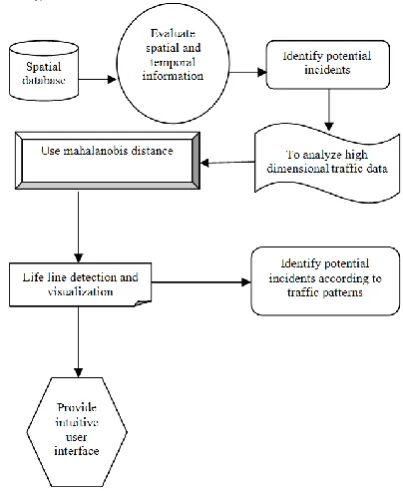
The proposed traffic occurrence detection using spatio temporal data mining approach comprises spatial-temporal data mining and revelation components. To identify incidents in the traffic streams, the proposed TODSTD will produce spatial-temporal traffic representations for every day-of-week supported on speed, amount, or possession. After that, the proposed work recognizes the outliers supported on contrasting real time traffic data with the chronological models. The traffic representation is termed as the characteristic day-of-week traffic data with incremental knowledge capability. The outlier will be envisaged to demonstrate the alarm altitude, location, and time. The architecture diagram of the proposed traffic occurrence detection using spatio temporal data mining approach is shown in fig 3.1.
Allowing for the association of the detector stations beside the expressway and the association all along the time line in mining procedure, Mahalanobis distance is utilized. Mahalanobis distance mainly used to determine the distinction between traffic data. It is finer to Euclidean distance since it records for varieties of suitability and recompenses for enslavements among variables. Mahalanobis distance D among sample data S and data model μ is termed as
)
1(
)
(
S
TS
, where Σ is the variance-covariance template of S and μ. For example, when present traffic is contrast with traffic model, S is the vector of habitation of all stations on present time period, and μ is the analogous feature in model with similar time distance. A significant disposition of Mahalabobis distance is that when S pursues multivariate normal allocation, D will follow Chi2 allocation. This quality assists to recognize the probability of incidence of a data point, which will be utilized to decide the outlier ness. Users are permitted to present feedbacks to authenticate the accuracy of outlier (incident) discovery. The comment assists to process the representation and progress the accurateness of recognition. Traffic Incidence Recognition Process
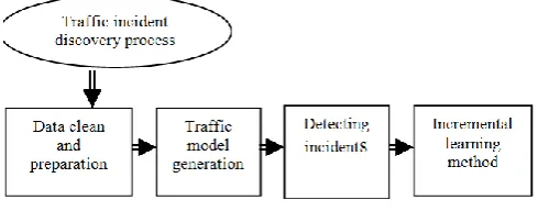
The traffic incident discovery process can be splitted into four steps and it is shown in fig 3.2 as planned below.
Fig 3.2 Traffic incidence discovery process
Step 1: Data Clean & Preparation
At first, the unrefined data repossessed from traffic detectors will be cleaned and prepared for the pulling out phase. As the data established from loop detectors encloses sound and mislaid values based by breakdown of the detector or communication problems, a data concentrated effort must be achieved to recognize and eliminate these data to guarantee the data superiority. Alternatively, the projected traffic daily representations are diverse from weekdays to weekends. Civic holidays also contain exclusive traffic prototypes. Consequently, a classification is desired to divide the traffic data into diverse weekdays and weekends. To review this task, three subtasks are planned as follows:
1. Examine the database and recognize the nonstandard records from failure detectors.
2. Mark the records of communal holidays.
3. Classify data of dissimilar weekdays and weekends by constructing split data views.
Step 2: Traffic Model Generation
In the model creation job, traffic data on diverse weekdays will be examined to create traffic representations correspondingly. While producing the model, some non-recursive events in the sanitary data sets, which emerged to be outliers, must be unconcerned to purify the traffic models. Provisional models
will be considered as the standard of chronological traffic data. For instance, standard speed charge at 12 PM on chronological days of station x will be employed as the speed at 12 PM on day of station x in the representation. Having the provisional model, Mahalanobis distance will be considered among the station-daily values in representation and in chronological data samples. When the Mahalanobis distance D is greater than a preset threshold d1, the analogous chronological station-daily example will be unconcerned from the model. After eradicating all the outliers, the ending traffic representations will be produced as the standard of the enduring chronological data. Three Steps are Planned to Review this Process
1. Compute the mean value for each traffic data vision for diverse weekdays and weekends.
2. Establish the incidents in chronological data utilizing Mahalanobis distance to.
3. Calculate the mean value after eradicating the outliers for daily-station traffic data vision as the ultimate models.
Step 3: Detecting Incidents
The third task is to determine possible incidents based on the traffic representation. The traffic data, which is reorganized each five minutes, is composed from the round detectors and unsoiled in runtime. Traffic recognition will be achieved by computing the Mahalanobis distance among real-time data and the equivalent time slot in the traffic representation. If the distance D is greater than threshold T, a potential incident will be recognized and a definite level of alarm will be accounted to the traffic hand. In case that the probable events have been identified in uninterrupted time slots, which specifies the high potentiality of genuine event, the alarm level will amplify to a confident value AL(t), in which t represents the consecutive time slots t. When no potential incidents are identified, the alarm level will reduce until it achieves the secure level. The subsequent steps review the incident recognition task.
1. Compute the Mahalanobis distance with the consequent vector, using the traffic data for all stations at time interval as a vector.
2. If the distance is greater than T, which can be determined by the unspecified allocation of Mahalanobis distance, there could be a potential event happens at that time point.
3. If successive probable incident happens in t time slots, the alarm level raises to AL(t).
Step 4: Incremental Learning Model
The system requires the ability to vigorously study from arriving traffic data to be flexible to situation alteration, for instance region development and road construction. The incessantly approaching traffic data with no precise incidents will be employed to delight the representation. After identifying the incident, user’s feedbacks on recognition precision will be composed. If the potential incident is confirmed as a accurate incident, the traffic data composed through the incident period will not be utilized in the representation. By integrating the novel traffic data into the unique representation, the traffic form will be rationalized. The principle to compute each novel daily-station traffic model
data
new
f
DS
old
f
DS
new
_
(
1
)
_
_
,where fading factor f is in (0, 1). The value of f establishes the knowledge rate of the traffic representation.
To achieve discovery in real-time, the variance-covariance matrices for every time slot should be considered earlier, since it is the most time-consuming process and would holdup the reaction of recognition if being designed on command. Consequently, when producing the simplified traffic representation, the variance-covariance matrices should be considered as well. Both the matrices and traffic representation will be stored for more event detection. These steps are reviewed as follows.
1. Compute the mean value of the subsisted model and the novel data with a fading factor f (0<f<1) as the novel model.
2. Calculate the matrices for both time points so as to analyze the Mahalonobis distance.
3. Store the representation and matrixes.
In the proposed TODSTD technique, the value of the parameters will seriously crash the efficiency of recognition. Specifically, these parameters are, distance thresholds t1 and t2, alarm level function LF(t), and fading factor f. Their values with their blows for incident recognition will be conversed in this section.
There are two distance thresholds used in the recognition procedure. Distance threshold t1 is employed to recognize the outliers when primarily producing the traffic model; t2 is employed to establish the probable incidents in real-time recognition. Then Mahalanobis distance uses Chi2 distribution, t1 and t2 can be allocated using the prospect of incident happening. Imagine there would be 5% of the days in which events would happen in definite station, t1 can be dispensed with the value which has the thickness of 95% Chi2 dispersed variable with the amount of freedom. For distance threshold t2, there will be 2% of the instance slot in a definite weekday or weekend in which events would happen, t2 can be termed as the value for range of 98% Chi2 distributed variable with freedom degree as number of stations on the direction. Alarm level function LF(t) produces a lifeline style illustration to the principle degree of event. When a probable incident is happened at first, a low initial alarm level LF(1) will be dispensed. Once the event is noticed in t time slots, the alarm level will raise to LF(t), in anticipation of attains a restriction (AL is sorted from 0 to 100). To recapitulate the above said process, definition of LF(t) is given as:
LF (t) = Min (LF (t-1) + k, 100), when event noticed in time slot t;
LF (t) = Max (LF (t-1) – k, 0), when no event noticed in time slot t.
As a result, LF (t) will differ from 0 to 100, and superior value specifies more potentiality to be an event. Constant k might organize the rising and falling rate of LF (t). Fading factor f is employed to decide the knowledge rate of the traffic representation. The value of f should be reliable to the traffic atmosphere. If the traffic situation is varying quickly owing to road structures, routing procedures, and weather conditions, f should be dispensed a moderately high value to reproduce on a short term collision. Or else, f can be little to construct the
model moderately steady for a long term representation. Using fading factor f, knowledge rate can be suitably processed. For instance, if we are planning to chiefly judge the traffic data of the most current 10 weeks, we can describe f to construct the data of 11th current week give less than a definite minute part in the traffic representation.
Experimental Evaluation
The proposed traffic occurrence detection using spatio temporal data mining approach is efficiently designed to perform the detection of traffic data and is implemeted in Java. Experimental examination and preliminary process have been done to estimate the detection efficiency on the traffic using proposed traffic occurrence detection using spatio temporal data mining approach. A real-time spatial-temporal pattern mining technqiue, specifically for the traffic data and fast response time is processed using active identification technique. A set of tests have been conducted in real system to validate the effectiveness and efficiency of the proposed TODSTD approach. An evaluation made on spatial and temporal information are measured to identify the possible incident. Nevertheless spatial database identification is diverse from conventional traffic occurrence identification methods. To examine the high dimensional traffic data, Mahalanobis distance is used to identify possible events with respect to the traffic pattern. The performance of the proposed traffic occurrence detection using spatio temporal data mining approach is measured in terms of
1. Tolerance 2. Effectiveness 3. Response time
RESULTS AND DISCUSSION
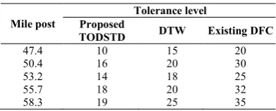
We implemented the spatial-temporal event recognition section in Java. Based on the proposed TODSTD system, a spatial chronological data mining constituent, user response utility and the analogous visualization are employed for event recognition assignment. Data fusing and organizing is achieved in this examination to fresh and combine the data previous to hoard them into traffic database. A data processing unit, which comprises spatial data representation and spatial-temporal mining utility, is employed to categorize the traffic data, and to determine intrinsic models from traffic records. Comapred to an existing Defending Against Fingerprint-Copy Attack in Sensor-Based Camera Identification (DFC) and DTW, the proposed TODSTD efficiently designed for event recognition system. The below table and graph describes the performance of the proposed TODSTD to detect traffic data occurrence.
Table 5.1 Mile post vs. Tolrenance level
Mile post
Tolerance level Proposed
TODSTD DTW Existing DFC
47.4 10 15 20
50.4 16 20 30
53.2 14 18 25
55.7 18 20 32
58.3 19 25 35
level of the proposed traffic occurrence detection using spatio temporal data mining approach is compared with an existing Defending Against Fingerprint-Copy Attack in Sensor-Based Camera Identification and DTW.
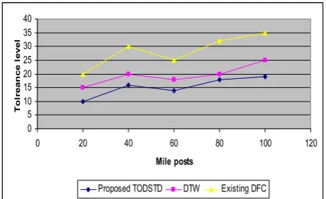
Fig 5.1 Mile post vs. Tolrenance level
Fig 5.1 describes the tolerance level of the traffic data based on the mile post specified. Tolerance is the maximum series of distinction that can be permitted i.e., it specified how much fault in the response is happening or is suitable. In a sequence of tests, the system replies small alarm points on various noises, i.e., light and non-persistent congestions, and exceeds the persistent congestions. Based on the mile post distance, the traffic data is analyzed and processed. In the proposed TODSTD, the tolerance level of the traffic is less since it followed the adaptive learning ability and short detection response time. To determine the high dimensional traffic data, mahalanobis distance is used to identify the potential events hapenning according to the traffic pattern. In DTW, based on the activity time of the data, the data has been processed but consumes more tolerance level. Compared to an existing DFC and DTW, the proposed traffic occurrence detection using spatio temporal data mining approach consumes less tolerance level and the variance is 25-35% low in the proposed TODSTD.
Table 5.2 Traffic data vs. Effectiveness
Traffic data
Effectiveness Proposed
TODSTD DTW
Existing DFC
10 30 25 10
20 45 35 20
30 60 43 15
40 54 50 19
50 68 45 23
The above table (table 5.2) describes the effectiveness of the traffic management based on the traffic data obtained. The effectiveness of the proposed traffic occurrence detection using spatio temporal data mining approach is compared with an existing Defending Against Fingerprint-Copy Attack in Sensor-Based Camera Identification and DTW.
Fig 5.2 Traffic data vs. Effectiveness
Fig 5.2 describes the the effectiveness of the traffic management based on the traffic data obtained in spatial and temporal information. The system provides peak fright levels (100%) to all the seven identified genuine incidents. In circumstances other than events in our tentative cases, the fright level not at all beats 80%, while is reserved from 0% to 30% in a large amount of the time. Compared to an existing Defending Against Fingerprint-Copy Attack in Sensor-Based Camera Identification and DTW, the proposed TODSTD provides a better efficiency in terms of maintaining the high dimensional traffic data. The proposed TODSTD reliably identified the genuine incidents occurring in the traffic occurrences and the variance is 30-40% high in it.
Table 5.3 Traffic data vs. response time
Traffic data
Response time (secs) Proposed
TODSTD DTW
Existing DFC
10 2.4 5.4 6.8
20 3.1 6.2 8.4
30 5.4 6.9 9.6
40 4.2 7.3 10.3
50 5.9 7.12 11.5
The above table (table 5.3 describes the response time of the propsoed TODSTD based on the traffic data obtained. The response time of the proposed traffic occurrence detection using spatio temporal data mining approach is compared with an existing Defending Against Fingerprint-Copy Attack in Sensor-Based Camera Identification and DTW.
Fig 5.3 Traffic data vs. response time
0 5 10 15 20 25 30 35 40
0 20 40 60 80 100 120
Mile posts
T
ol
r
e
a
n
c
e
l
e
v
e
l
Proposed TODSTD DTW Existing DFC
0 10 20 30 40 50 60 70 80
0 10 20 30 40 50 60
Traffic data
E
ff
e
c
ti
v
e
ne
s
s
Proposed TODSTD DTW Existing DFC
0 2 4 6 8 10 12 14
0 10 20 30 40 50 60
Traffic data
r
e
s
po
ns
e
t
i
m
e
Fig 5.3 describes the response time based on the queries obtained for retrieving the traffic data. In the experiments, no further response time for recognition and revelation is vital, except for the time to freight a fixed web page in browser, i.e., typically fewer than 3 seconds (based on the network). The main cause is that there is a conditions series doing the real-time recognition and depicting the plans all the real-time. When the traffic incidence recognition results are demanded from the web, an analogous HTML page will exhibit the newly concluded charts. Consequently, the response time is only based on the network link. In addition, the perceiving program regularly concludes spotting for one time period and depicts the charts in roughly one second. Performing the tests on identified events, our approach demonstrates its effectiveness, and the capability to hold real time and noise data in genuine traffic organization system.
Finally it is being observed that the proposed work is effiicently identified the possible incidents occurring in the spatial and temporal features of the given image. Mahalanobis distance measure is used to determine the high dimensional data traffic structure obtained in the spatial database.
CONCLUSION
In this paper, we suggest a novel technique to recognize event in real time. It is supported on spatial-temporal data vision and relates Mahalanobis distance to believe the association of traffic data from adjoining stations and uninterrupted time slots. A support to method alarm point for events is implemented to sustain efficient data navigation. Our proposed TODSTD approach employs user feedback to sustain learning capability. Furthermore, fast response time is attained by utilizing vigorous recognition strategy. A set of experiments have been examined in genuine system to authenticate the efficiency and competence of the proposed TODSTD approach. The proposed TODSTD approach can also be used to other applications which believe both chronological and spatial features, such as weather monitoring and disease control. Experimental results showed that the proposed novel technique reliably identified the incidents occurring in the traffic data system both in the spatial and temporal features of the given fingerprint image.
Reference
1. Du Rongyi et. Al., “Design of Control Unit of Traffic Detection System Based on ARM”, International Conference on Intelligent Computation Technology and Automation (ICICTA), 2008
2. Ju-Won Hwang et. Al., “Hierarchical Probabilistic Network-Based System for Traffic Accident Detection at Intersections”, 7th International Conference on Ubiquitous Intelligence & Computing and 7th International Conference on Autonomic & Trusted Computing (UIC/ATC), 2010
3. Xinting Pan et. Al., “Traffic Surveillance System for
Vehicle Flow Detection”,
Second International Conference on Computer Modeling and Simulation, 2010. ICCMS '10.
4. Hsu-Yung Cheng et. Al., “Intelligent Highway Traffic Surveillance With Self-DiagnosisAbilities”, IEEE Transactions on Intelligent Transportation Systems, 2011 5. Agarwal, V. et. Al., “A Cost-Effective Ultrasonic Sensor-Based Driver-Assistance System for Congested
Traffic Conditions”,
IEEE Transactions on Intelligent Transportation Systems, 2009
6. Rui Wang et. Al., “EasiTia: A Pervasive Traffic Information Acquisition System Based on Wireless
Sensor Networks”,
IEEE Transactions on Intelligent Transportation Systems, 2011
7. Yen-Lin Chen et. Al., “A Real-Time Vision System for Nighttime Vehicle Detection and Traffic Surveillance”, IEEE Transactions on Industrial Electronics, 2011 8. Jia Liu et. Al., “Monitoring the spatial-temporal effect of
internet traffic based on Random Matrix Theory”, 33rd IEEE Conference on Local Computer Networks, 2008. LCN 2008.
9. Yen-Lin Chen et. Al., “Real-time vision-based multiple vehicle detection and tracking for nighttime traffic surveillance”,
IEEE International Conference on Systems, Man and Cybernetics, 2009. SMC 2009.
10. Guiyan Jiang et. Al., “The method of traffic congestion identification and spatial and temporal dispersion range estimation”,
2nd International Asia Conference on Informatics in Control, Automation and Robotics (CAR), 2010
11. Miroslav Goljan et. Al., “ Defending Against Fingerprint-Copy Attack in Sensor-Based Camera Identification”, IEEE Transactions on Information Forensics and Security, March 2011
12. Kevin Adistambha et’al, “Motion Classification Using Dynamic Time Warping”, International Workshop on Multimedia Signal Processing 2008.
How to cite this article:
K. Kalaivanan and Dr.P.Parmeswari., 2019,Traffic Occurrence Detection Using Spatio Temporal Data Mining. Int J Recent Sci Res. 10(05), pp.32424-32429. DOI: http://dx.doi.org/10.24327/ijrsr.2019.1005.3468