Survey on Spatio-Temporal Database and Data Models
with relevant Features
Sonia Rathee
*, Amita Yadav
***
Computer science & Engineering, Maharaja Surajmal Institute of Technology, New Delhi, India
**
Computer science & Engineering, Maharaja Surajmal Institute of Technology, New Delhi, India
Abstract- Spatio-temporal data is the abstract of the spatio-temporal characteristics and process of the real world .Spatio-temporal database modeling on the earlier stages attempted to capture the state of real world objects or the physical event upon them ,on the time line .The spatio-temporal data models integrates time and space so it can truly describe the reality . In this paper ,we have review the different types of spatio-temporal datamodels that have been proposed in the literature as welll as new theories and concepts that have emerged .
Index Terms- Temporal Database;Spatial Database ;Temporal Model;:Spatial Model;Spatio-Temporal Datamodels
I. INTRODUCTION
database management system are responsible for the storage and processing of huge amounts of information . The data stored by these database systems refers to information valid at present time ,valid now. It concerns data that is believed to be true in reality at the present moment . Past data refers to information that was stored in the database at an earlier time , data that is believed to have existed in the past , valid at some time before now . Future data refers to information considered to be valid at a future time instance , data that will be true in the near future , valid at some time after now[1].
Different types of Database systems (as shown in Fig.1) :-
1. Relational database :-Stores data in tables , known as relation .
2. Object oriented database:- stores data about entities in object .Sets of objects of the same type are called collections .Thus an object oriented database contains a set of collections
3. Spatial Database :- concerning the storing of data in relation to space . It offers spatial data types and stores information relating to geometric or geographical space . The spatial database stores a collection of space related data .
4. Temporal data base :- stores data relating to time instance .It offer temporal data types and stores information relating to past present and future e.g. The history of the stock market or the movement of the employee with an organization . Thus a temporal database stores a collection of time related data .[2]
Figure 1: Types of Database
From the above listed four database models, the two models namely : Temporal database ,Spatial database will be used in the present work . The description of these two models are as explained below.
II. TEMPORAL DATABASE
Temporal data is any data that contains temporal information, where time can be either real or logic. To categorize temporal data, one can adopt different criteria. Below we list several commonly used categorizations for temporal data [3]. Partially Temporal vs. Fully Temporal:- A temporal dataset is partially temporal if it contains data items whose temporal relationships such as before and after are undecidable. For instance, web log is partially temporal, as it is often impossible to decide the exact access time to the same web page from different web sessions. In contrast, in a fully temporal dataset, the temporal relationship between every pair of data items is decidable:-
Regularly Timestamped vs. Irregularly Timestamped:- In regularly timestamped data, measurements are recorded at equal-spaced time points. Otherwise, the data is irregularly timestamped.
Univariate vs. Multivariate:- Univariate temporal data describes the temporal behavior of one variable. Multivariate temporal data on the other hand describes the temporal behavior of more than one variable.
Uni-subject vs. Multi-subject:- A uni-subject temporal data involves only one subject.Whereas a multi-subject temporal data involves more than one subject
A
Database system
Relational database
Object oriented database
Temporal database
III. SPATIAL DATABASE
Spatial data consists of three components: map(s), spatial objects or entities, and auxiliary information. The first component, map(s), typically defines a universal reference space for all the involved objects. More than one map can be involved in a spatial dataset .For instance, it is common for data in geographic information systems to consist of maps of multiple cities. Each map contains a set of spatial objects, where each object can be uniquely identified by its location. Auxiliary information, the third component of spatial data, usually contains supplementary data, for instance, proprietary information .To represent spatial data, we have the following two major representation schemes: raster and vector [4]. The raster scheme is attribute-oriented,it transforms spatial data into a collection of pixel-based layers.Each layer is associated with one object attribute of interest (e.g. object size ) and is constructed in the following manner .For each object , it first identifies all the pixels that are occupied by the object , and then assigns each identified pixel the attribute value of the said object .
Thus a layer represents the saptial distribution of all the objects in a given map with respect to the layers associated attribute .In contrast to the raster scheme ,the vector representation scheme is object-oriented. It considers each spatial object as a whole, and represents it as a vector of attributes of interest. The main features of spatial data are:-
Spatial Correlation or Autocorrelation[5]. Complex Spatial Relationships [6]
Topological relations
Directional relations
Metric relations
Set oriented relations Large Data Volume [7]
Expensive Spatial Operations
IV. SPATIAL AND TEMPORAL DATA MODEL
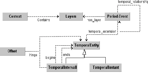
TEMPORAL DATAMODEL:- The temporal model( shown in Figure 2) , presents the qualitative and quantitative aspects of time references using the de facto standard model [8] with the granularity concepts studied in theoretical works [9], making it possible to partition the temporal domain in thematic contexts, each of them with its granularity, and to make quantitative and qualitative temporal references.
Each Layer contains Period-Events, expressing the Temporal Reference of an object. If the Temporal Reference is quantitative, then the Period-Event has a temporal_extension property that refers to a Entity object. A Temporal-Entity can be a Temporal-Instant or a Temporal-Interval. A Temporal-Interval can begin and/or end with a precise dating or with other Temporal-Entities, or can be an Offset hinging on another Temporal-Entity. If the Temporal Reference is qualitative, then the Period-Event object has a temporal_relationship property that refers to another Period-Event object in the same Context[10].
SPATIAL DATAMODEL:- The spatial model (as shown in Figure 3) aims at managing two aspects of spatial entities: 1. Places that evolve in time (i.e. for name or shape);
2. Hierarchical and stratified spatial domains, ie thematic contexts with a stratified granular structure similar to the temporal dimension . [11]
We consider the entity Place as an abstract entity with only semantic meaning, having an Id, a name and a description. A Place can change its spatial extension over time, i.e. it can change its boundaries. In order to manage this ChangeShape object we introduce the entity “ST-Place-Istance”, having the Place as external reference, the Period-Event of validity and a reference to the OGC Geometry by means of which it is spatially represented. Users can organize the spatial domain with different semantic meaning e.g. with thematic maps. Similarly to the temporal dimension, also the spatial domains are organized in thematic contexts. Each Context has a spatial domain partitioned into Layers.
Figure 3:- Spatial Model
V. SPATIO-TEMPORAL DATABASE & DATA MODELS
Spatio-temporal databases deal with applications where
[image:2.612.44.296.578.702.2]dimensions, together with the representation and manipulation of the data involved. Therefore, the earlier work in this area began from separate research in both temporal [3] and spatial [10] databases. This effort later became the basis for spatio-temporal database models.
Spatio-temporal datamodels are the core of a Spatio-Temporal Information System (STIS); they define object data types, relationships, operations and rules to maintain database integrity Spatio-temporal data is usually modeled by extending temporal database or spatial database . That is , spatio-temporal data is modeled in two ways . First we can add spatial properties and operations in temporal databases. The second way is to add temporal properties and operations in spatial databases.A rigorous data model must anticipate spatio-temporal queries and analytical methods to be performed in the STIS. Spatio-temporal database models are intended to deal with real world applications, where spatial changes occur over the time line. A serious weakness of existing models is that each of them deals with few common characteristics found across a number of specific applications. Thus the applicability of the model in different cases, fails to explain the behavior of spatio-temporal data which is not anticipated by the application used for the initial model development[12].
Spatial-Temporal Integration A rigorous data model must be able to manage and foresee any required spatio-temporal query and analytical method[13]. The proposed classification, inspired by previous works [14,15, 16],considers the temporal dimension to be dynamic and based on two binary dimensions:
Spatial Position: the object spatial location changes over time.
Spatial Extension: the object shape (geometry) changes
over time.
From these two dimension four classes of spatio-temporal object are obtained (Figure 4):
ST-Event: objects that do not change neither their position nor shape over time but that could change their descriptive component.
Moving-Object: objects that change their position but not their shape over time.
Change-Shape: objects that can change their shape
(geometry) but not their position.
Evolution-Object: objects changing their shape and
position over time.
Dimensions Change Positions Change shapes
ST object No No
Moving object Yes No
Evolution object Yes Yes
Change shapes No Yes
Figure 4: Spatio-Temporal Classification
VI. CLASSIFICATIONS OF SPATIO-TEMPORAL DATA MODELS
Spatio-temporal data models [17] are classified into the following ten classes:
The snapshot model: where spatio-temporal data is modeled as a sequence of pure spatial data recorded at different time moments.
The space-time composite model: which is based on the principal that every line in space and time can be projected to the spatial plane and be intersected with each other to create a polygon mesh.
Data models based on simple time-stamping, where each object is simply tagged with two timestamps associated with the object’s creation and cessation.
The event-oriented model, where events are of major concern and spatial objects are only participants of events. The three-domain model: which identifies semantics, spatial domain, and, temporal domain for spatio-temporal data. The links between space and time are described through different semantics.
The history graph model: the main purpose of this type of models is to identify all types of changes. Thus it manage both events and objects.
The spatio-temporal entity-relationship model: which extends the well-known Entity-Relationship (E-R) data model to spatio-temporal data.
The object-relationship model, where processes that cause different changes are abstracted as a type of relationship among spatio-temporal objects.
The temporal object-oriented model, where a spatio-temporal object is defined as a unified object with both spatial and temporal extents.
The moving object data model, where spatio-temporal data is abstracted as a collection of moving objects including points and regions. It models time as an integral part of spatial entities and captures both changes and movements.
FEATURES OF SPATIO-TEMPORAL DATA MODEL:- The spatio-temporal data models [18] are describe with the following features in table 1 :-
Formalisation: This factor shows if the model has been formally defined or not.
Implementation: This criterion depicts if the model has been implemented or not.
Tool: If the model has been implemented, the name of the tool developed is listed here.
Application: The case study used to analyse and develop the model.
Spatial model: The spatial model used as the basis for the development of the corresponding spatio-temporal model.
Table:-1
*GIS Geographic Information System *LIS Land Information System
VII. CONCLUSION
Spatio-temporal database modeling on earlier stages attempted to capture the state of real world objects or the physical events upon them ,on the time line. The investigation is done in the real world application which brought out new directions and requirements for further developments. On the time line the process is continuous changes and were investigated and models to capture them were proposed .The spatio temporal models are more concerned with conceptual notation of spatio temporal data . In future the next step in spatio temporal data base development is the testing stage where the models proposed and run on different applications to identify further requirements and research directions.
REFERENCES
[1] C.S. Jensen, J. Clifford, R. Elmasri, S.K. Gadia, P. Hayes and S. Jajodia, eds., “A Glossary of Temporal Database Concepts” ACM SIGMOD Record, vol. 23, no. 1, pp. 52-64, Mar. 1994.
[4] O. Guenther and A. Buchmann. ``Research Issues in Spatial Databases'', SIGMOD Record, Vol. 19:61-68,1990.
[5] H. Yang, K. Marsolo, S. Parthasarathy, and S. Mehta. “Discovering spatial relationships between approximately equivalent patterns”. In BIOKDD04:
Workshop on Data Mining in Bioinfomatics (with SIGKDD04 Conf.), August 2004 .
[6] M. J. Egenhofer and J. R. Herring. “Spatial and Temporal Reasoning in Geographic Information Systems”,Oxford University Press ,New York,1998.
[7] A.G. Cohn and S.M. Hazarika. “Qualitative spatial representation and reasoning: An overview”, Fundamental Informatics, 46(1-2):1–29, 2001 [8] M. Koubarakis, T.K. Sellis et al.(eds.),”Spatio-Temporal Databases: The
Chorochronos approach” Springer-Verlag LNCS 2520, 2003.
[9] C. Bettini, X. S. Wang, and S. Jajodia, "A general framework and reasoning models for time granularity", Proceedings of Third International Workshop on Temporal Representation and Reasoning (TIME '96), pp. 104-11,1996. [10] James F Allen, "Time and Time Again: The Many Ways to Represent Time"
Journal of Intelligent Systems, vol. 6, pp. 341-355, July 1991
[11] Max J Egenhofer ,” what is special about spatial database requirements for vehicles navigation in geographic space ”, SIGMOD Rec.,vol.22,no. 2, pp.398—402,june 1993.
[12] T. Abraham and J. F. Roddick. “Survey of spatio-temporal databases”. Geoinformatica, 3(1):61–99, 1999.
[13] M. Yuan, "Temporal GIS and Spatio-Temporal Modeling " in Proceedings of Third International Conference on Integrating GIS and Environmental Modeling, Santa Fe, New Mexico, USA, 1996.
Spatio-Temporal datamodels
Formalisation Implementation Tool Application Spatial Model Temporal Model
Snapshot No No None LIS GIS N/A
STC No No None LIS GIS N/A
Simple Time Stamping
No No None Historical cadastral
database
US spatial data transfer standard
N/A
Event Oriented Yes Yes TEMPEST LIS GIS with event
dates
Ordered time models
3-Domain Yes No None LIS Relational spatial
database
Relational version tables
History Graph No No None LIS N/A Graphs
STER Yes No None Cadastral
application
Spatial indicator Temporal indicators
O-R Yes Yes MADS Rural urban land use
application
MEOSIG MODUL-R
POLLEN
O-O Yes Yes Geo-OM LIS ERT model Temporal
base model
STUML Yes No None Regional health care
example
Spatial indicator Temporal indicators Moving
Objects
Yes Yes SECONDO
module
Multimedia
scenario, Forestfire control management
Abstraction of spatial data types & Oracle Spatial
[16] S. Nadi and R.D. Mahmoud, "Spatio-Temporal Modeling of Dynamic Phenomena in GIS," in ScanGIS'2003 - The 9th Scandinavian Research Conference on GIS, 4-6 June 2003- Proceedings, Espoo, Finland , pp. 215- 225,2003.
[17] N. Pelekis, B. Theodoulidis, I. Kopanakis, and Y. Theodoridis. “Literature review of spatio-temporal database models”. Technical report, Center of Research in Information Management (CRIM), Department of Computation, UMIST; Department of Informatics, University of Piraeus, 2005.
[18] C. Bettini, X. S. Wang, and S. Jajodia, "A general framework and reasoning models for time granularity," in Proceedings of Third International Workshop on Temporal Representation and Reasoning (TIME '96), pp. 104-111,1996.
AUTHORS
First Author – Sonia Rathee, Computer science & Engineering
Maharaja Surajmal Institute of Technology, New Delhi ,India [email protected]
Second Author – Amita Yadav, Computer science &