Morphological variability of submarine mass movements in the tectonically-controlled Calabro-Tyrrhenian Continental Margin (Southern Italy).
Daniele Casalbore1,2, Alessandro Bosman2, David Casas3, Francesco Latino Chiocci1,2, Eleonora Martorelli2,Domenico Ridente2
1
Department of Earth Sciences, Sapienza University of Rome (Italy) 2
CNR-IGAG- (Rome, Italy) 3
IGME, Madrid, Spain
ABSTRACT
The acquisition of high resolution morpho-bathymetric data on the Calabro Tyrrhenian continental
margin (Southern Italy) enabled us to identify several mass-wasting processes, including shallow
gullies, shelf-indenting canyons and landslides. In particular, we focus our attention on submarine
landslides occurring from the coast down to -1700 m, with mobilized volumes ranging from some
hundreds up to tens of millions of cubic meters. These landslides also show a large variability of
geomorphic features in the headwall, translational and toe domain. Based on their morphology and
distribution, four main classes of coastal/submarine landslides have been recognized: a) rocky
coastal/shallow-water failures characterized by large hummocky deposits offshore; b) large-size and
isolated scars with associated landslide deposits, mostly occurring on open slope environment and
lower part of tectonically-controlled escarpments; c) a linear array of coalescent and nested
landslide scars occurring in the upper part of tectonically-controlled escarpments and canyon flanks;
d) a cauliflower array of small and coalescent scars occurring in canyon headwall. The latter two
classes of landslides are also characterized by a marked retrogressive evolution and their landslide
deposits are generally not recognizable on the morpho-bathymetric data. By integrating the morpho-bathymetric dataset with the results of previous studies, we also discuss the main factors controlling the variability in size and morphology of these submarine landslides to provide insights on their failure and post-failure behavior.
KEYWORDS
landslide scars; canyon; fault escarpments; contourite deposits; digital elevation model; continental slope
1 INTRODUCTION
Landforms associated to submarine mass movements are ubiquitous in all marine settings at very
different depths and slope steepness [1-3]. Their study has significantly increased in the last two
decades in relation to the technological advances both in seafloor imagery system and seismic
techniques as well as to the growing interest for their hazard potential [4-5]. These events can
directly impact offshore or coastal infrastructures [6-7] or cause local but destructive tsunami
waves, as for instance observed at Nice in 1979 [8] and Stromboli in 2002 [9]. The tsunamigenic
potential of mass movements greatly depends on the water depth and size of the slope failure, even
if the geometry, initial acceleration and velocity play a significant role [5]. Until now attention is
mainly focused on large-scale mass-movements (volumes in the order tens or thousands of cubic
kilometers) capable to produce regional tsunamis with wave heights of tens of meters. Smaller
landslides in shallow-water areas have been often overlooked, even if they could be also more
hazardous than the larger ones, because they typically occur more frequently than the larger events,
and they can generate local but destructive tsunamis [7]. This kind of landslides is very common in
geologically-active margins, where mass-wasting processes can affect percentage of seafloor areas
higher than 50% (and up to 90% in some cases; [10 and reference therein]). This is, for instance, the
case of the tectonically-active Calabro-Tyrrhenian margin encompassed between Cape Vaticano to
the north and the Messina Strait to the south (Fig. 1). This margin formed during the opening of the
back-arc Tyrrhenian Basin, in turn controlled by the NW-oriented subduction of the Ionian crust
extensional faults since the Miocene [12-13], able to produce large and frequent earthquakes, such
as the 1783 seismic sequence, the Capo Vaticano 1905 or the Messina 1908 events [14].
Fig. 1 Shaded relief map of the Calabro-Tyrrhenian continental margin encompassed between
Cape Vaticano and the Messina Strait (location in the inset), with the indication of the recognized
landslide scars (red lines from [15]) and the location of the following figures (blue boxes)
The coastal area is also affected by relevant uplift rates (rates up to 2 mm per year) since the Middle
Pleistocene [16]. Because of this tectonic uplift, the shelf is commonly narrow and steep, and it
receives a large amount of sediment by subaerial erosion of the coastal range. This latter is, in fact,
carved by a network of steep and short river courses, locally named Fiumara [17], characterized by
Due to the concomitant occurrence of all these preconditioning and triggering factors, this
continental margin is largely affected by widespread mass-wasting processes ranging at different
spatial scales during time. A basin-scale mass-transport deposit (Nicotera Slump, [21]) covering an
area of 636 km2 and with an estimated volume of about 30 km3 is recognizable in the slope
stratigraphy. Over 400 landslide scars are recognizable on the morpho-bathymetric data, affecting
an area of >85 km2 and mobilizing approximately 1.4 km3 of sediment (Fig. 1; [15]).
In this paper, we deal with the landslides recognizable on multibeam bathymetry to evidence the
variability of geomorphic features related to these submarine mass movements along the
Calabro-Tyrrhenian Margin through a review of selected case studies. This dataset is also used to discuss
what are the main factors in controlling the failure and post-failure behavior of the recognized
landslides.
2 DATA AND METHODS
The data presented in this study are morpho-bathymetric data collected during several
oceanographic cruises performed onboard Urania and Minerva1 vessels (National Research
Council) and small boats for shallow-water surveys. Data were acquired between the coast and
2000 m water depth using multibeam systems (Kongsberg and Teledyne Reson) working at
frequency of 50-455 kHz in order to gain the best resolution for each bathymetric interval. Data
were processed with Caris Hips and Sips and gridded at variable cell-size, ranging from 1 m in
shallow-waters to 25 m in deep-waters.
3 LANDFORMS ASSOCIATED TO SUBMARINE MASS MOVEMENTS
Geomorphic features related to mass-wasting processes are widespread in the study area, and
variably incising the shelf and slope. In this work, we focus on features related to submarine mass
movements, i.e. landslide scars and associated deposits. The distribution of these landforms is not
random but concentrates in some areas, reflecting the larger scale geomorphic and tectonic setting
of the continental margin, characterized by submarine canyons (3.1), tectonically-controlled
escarpments (3.2) and open slopes (3.3).
Besides these submarine landslides, blocky deposits associated to coastal rocky failures are also
recognizable in the study area. The most striking example occurs off the Scilla village, where a
cluster of hummocky reliefs, with a diameter of 20–180 m and height of 2–30 m with respect to the
surrounding seafloor is recognizable at the base of the continental slope between -270 and -305 m
(Fig. 2). These deposits were related to the Mt. Pacì 1783 tsunamigenic landslide, triggered during
the second main shock of the 1783 earthquake sequence [22]. Nevertheless, the presence of a
submarine scar coaxial with the subaerial one could suggest a multiple event and raise questions on
the timing/triggering relationships between the two failures [23]. It is also noteworthy that similar
blocky deposits associated to rocky coastal landslides have been found northward, close to Palmi
village [23].
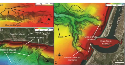
3.1 Submarine mass movements on submarine canyons
In the study area, a main canyon-channel system is present, being formed by the Gioia and Mesima
shelf-indenting canyons (Fig. 1; [13,24]). Minor channels are also recognizable, such as the
Bagnara Channels in the southern part. Landslide scars are recognizable both at the headwall and
flanks of the Gioia-Mesima canyons system, commonly showing a semicircular and regular shape
(Fig. 3). On the contrary, the morphological evidence of clear deposits associated to landslide
deposits is often lacking on the multibeam bathymetry. Landslide scars occurring along the canyon
flank generally have a larger size (diameters ranging from some hundreds of meters up to few
often coalescent and nested each other, forming a linear to sinuous array of instability features
following the main path of the canyon.
Fig. 2 3-D view of the hummocky deposits related to the 1783 Monte Pacì rocky and tsunamigenic
landslide occurring off Scilla village, for location see Fig. 1.
Differently, the canyon headwall is often characterized by a cauliflower shape, formed by small
(100–200 m wide) and coalescent scars, which affect the littoral wedge at depths < 15 m, thus
and time-lapse multibeam bathymetries collected in the last decade at the headwall of the Gioia
Canyon and Bagnara channels evidenced the occurrence of repeated retrogressive landslide scars
[23,25]
Fig. 3 a) 3-D view of the coalescent landslide scars affecting the outer flanks of the Mesima Canyon
b) 3-d view of the Bagnara Channels (b), where a cauliflower headwall formed by small landslide
scars present is recognizable along with coaxial trains of crescent-shaped bedforms. c) Shaded
relief of the upper reach of Gioia Canyon head, formed by two branches that isolate the entrance of
the Gioia Tauro harbor. Note the cauliflowers shape of the southern headwall of the Gioia Canyon
as well as coalescent and nested landslides scars present along the flanks of the Gioia Canyon.
Location of the figures 3a, b and c is provided in Fig. 1.
These slides can mobilize volumes comprised between 5.000 and 50.000 m3 and are able to produce
a coastal retreat of the littoral wedge in the order of tens of meters for each event. Moreover,
channelized features located downslope of these scars are characterized by occurrence of coaxial
trains of arcuate or crescent-shaped bedforms, with wavelength of tens to hundreds of meters and
amplitude of a few meters (Figs. 3b and c).
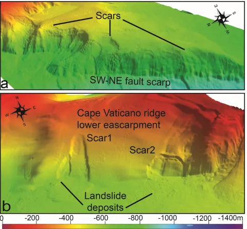
Several tectonically-controlled scarps are present in the area. One of the most prominent morpho-structural features of the area is the Capo Vaticano ridge extending down to 1000 m water depth (Figs 1 and 4). Particularly, the SW and NE flanks of this ridge are formed by linear, steep (7°-20°) and up to 300 m high escarpments, suggesting a tectonic control on their development. Downslope, the Cape Vaticano ridge is cut by a 20 km long and few hundred meters high fault scarp between -1000 and -1400m, oriented along a SW-NE direction (scarp1 in Figs 1). Minor SW-NE escarpments are also present between -800 and -600 m, even if they are markedly less steep and high with respect to the previous one (scarps 2 and 3 in Fig. 1).
Fig. 4 (a) 3-D view of the SW-NE tectonically-controlled escarpments recognized in the lower
continental slope off Capo Vaticano ridge (for location see Fig. 1), largely affected by nested and
coalescent disintegrative-like landslides. (b) 3-D view of the tectonically-controlled escarpment
forming the SW flank of Cape Vaticano ridge (for location see Fig. 1), where isolated landslide
scars with associated deposits are present.
3.3 Submarine mass movements on open slopes
On multibeam bathymetry, relatively few landslides can be observed on the open slope sectors,
landslides were identified on the continental slope comprised between Cape Vaticano and the
Mesima Canyon between -700 and -1000 m (Fig. 5a). This sector is adjacent to the Capo Vaticano ridge but can be considered an open slope sector as minor tectonic control is indicated by seismic
profiles [26]. The first scar (S3 in Fig. 5a) is approximately 3.5x4 km and has head-scarp with height of 20-60 m (on average 35 m) and slope gradients of 20°-40°. Small blocks and ridges are present at the base of the main head-scarp, indicating occurrence of material that is not completely evacuated from the scar. Downslope, the detached landslide mass is recognizable on the bathymetry and mostly confined within the landslide scar. Seismic profiles also show that landslide deposits are downslope confined from the northern levee of the Mesima Canyon [26]. The second scar (S4 in Fig. 5a) is approximately 2x4 km and its head-scarp is characterized by an average height of 25 m, with slope gradients of approximately 20°. The scar shows an overall smooth morphology and no clear landslide deposits are recognizable on the bathymetry. The third scar (S5 in Fig. 5a) is 1.7x2.7 km, displaying an overall subdued relief, with a 4-15 m high head-scarp.
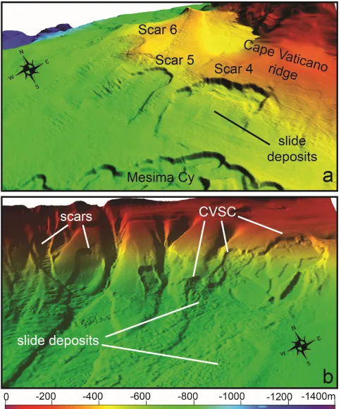
Besides these slides, a large landslide complex is recognizable in the upper continental slope off Cape Vaticano (and for this reason named Capo Vaticano Scar Complex, CVSC hereafter, [27]) between -190 m and -500 m. The CVSC covers an area of about 18 km2, with an estimated mobilized volume of approximately 175x 106 m3. The CVSC is formed by four main landslide scars, having scarp with height of 10–25m, and several minor scars with 2–5m high head-scarps. It is noteworthy that the landslide morphology is variable along the CVSC, with the northern part mostly dominated by scars showing a rugged morphology due to material not completely evacuated during the failure, such as detached blocks and ridges parallel to the main head-scarp. On the contrary, the southern part of CVSC is mainly characterized by coaxial and tabular scars having an overall smooth appearance and affecting the steep seaward side of a contourite drift.
Fig. 5 3-D view of the landslide scars affecting the open continental slope encompassed between
Cape Vaticano ridge and Mesima Canyon (a) and the Capo Vaticano Scar Complex (CVSC)
DISCUSSIONS
5.1 Distribution and variability of submarine mass movements and related controlling factors
The previous section has evidenced the widespread distribution and variability of landforms associated to submarine mass movements in the sector of the Calabro-Tyrrhenian margin comprised between the Cape Vaticano and the Messina Strait, where semi-circular to elongated landslides scar, with variable size and morphology are present. Even if landslides morphology and distribution can be controlled by several factors and processes, varying in space and time (e.g., slope gradients, fall height, lithological characteristics, tectonic activity, sediment supply, pore water overpressure, cyclic load induced by earthquakes or waves, flank undercutting due to turbidity currents), it is noteworthy that most of the observed variability seems to be strictly related to different physiographic/morphological domains where the landslide formed. Based on their morphology and distribution, four main classes of submarine landslides can be recognized: 1) rocky coastal/shallow-water failures associated with cluster of hummocky deposits; 2) large-size and isolated scars with associated landslide deposits, mostly occurring on open slope environment and lower part of tectonically-controlled escarpments; 3) a linear array of coalescent and nested, disintegrative-like landslide scars occurring in the upper part of tectonically-controlled escarpments and canyon flanks; 4) a cauliflower array of small and coalescent disintegrative-like scars occurring in canyon headwalls. In this classification scheme, the CVSC represents a peculiar case of a large complex of coalescent and nested landslide scars developed on the upper continental slope, where a mixed turbidite–contourite system is present [27].
channelized features, suggesting the occurrence of retrogressive failures for their origin [28]. The overall small size of such failures can be mostly related to the steep slope gradients occurring in canyons flanks and tectonically-controlled escarpments coupled with the frequent seismicity that characterizes the study area. In such setting, sediments cannot accumulate over large areas and for long time spans, giving rise to large-scale failures, as typically observed on the mid and lower continental slopes [29-31]. This finding agrees with submarine landslide inventories in other steep and geologically-active areas, such as in the Gulf of Corinth [32], Gulf of Naples and surrounding areas [33] and offshore Pontine Islands [34-35]. Steep gradients are also likely responsible for the disintegrative-like behaviour characterizing most of these slides [30], i.e. scars having a smooth morphology and associated landslide deposits not recognizable on the bathymetry. This behavior might be related to the fact that slide sediment either lost cohesion during failure or failed as a cohesive mass but disintegrated downslope due to the low mobilized volume and high energy (steep gradients and fall height). In this regard, it should be considered that the total fall height of the slope failures seems also to control the degree of the disintegration of the failed material. In fact, only for those scars located in the lower part of the steep flank of Capo Vaticano ridge, the related mass-transport deposits are still recognizable on bathymetry (Fig. 4b). This evidence is consistent to what was observed along other tectonically-controlled scarps, as for instance on the intraslope Palmarola ridge [36].
ridge, the cohesive-type S4 slide was confined downslope by the northern levee of the Mesima Canyon with respect to the less confined setting of the disintegrative-like S5 slide. It is also noteworthy that S5 slide is characterized by a lower height and slope gradients of the head-scarp with respect to the S4 slide, suggesting a failure occurring within a weaker or less cohesive material
[40]. In the case of CVSC, cohesive-like slides preferentially occur in the northern part of the CVSC, where mixed turbidite–contourite deposits are present, while disintegrative-like slides mainly affected the contourite drifts developed in southern part (Figs. 5b; [27]). This distribution suggests that the different post-failure behavior of the recognized slides can be due to the difference in sediment type (mixed turbidite– contourite deposits vs contourites) mobilized during the failure events along with the occurrence of steep gradients on the seaward side of the contourite drifts.
5.2 Preliminary considerations on the potential geohazard associated to the submarine mass
movements in the Calabro-Tyrrhenian continental margin
In this section, we attempt to roughly assess the hazard potential associated to the recognized landslide scars. On the whole, the hazard related to the landslides affecting open slopes can be considered overall low, as these events are relatively few and they commonly occur at depths greater than -120 m. In this depth range, their size is not able to generate significant tsunami waves for surrounding coastal sectors according to a rapid estimation of their potential tsunamigenic based on semi-empirical equations available in the literature [41] and already used in the nearby areas [33, 42]. Similar consideration can be applied also to the small- and medium-size disintegrative-like affecting the tectonically-controlled escarpments and canyons sidewalls present in the area.
106 m3 of material failed at the head of the Gioia Canyon in 1977 during the harbor construction (Fig. 4a; [43]). It is noteworthy a similar tsunamigenic landslide occurred two years later off Nice at the head of Var Canyon during the enlargement of the harbor, causing several damages and casualties [8]. The recent sedimentary activity of Bagnara Channels and Gioia Canyon is witnessed by recognition of crescent-shaped bedforms in their thalweg, commonly recognized in active channel/canyon elsewhere. This activity might be related to the occurrence of small retrogressive failures at the headwall of these channelized features, as evidenced by multi-lapse bathymetric surveys [25]. Another relevant source of hazard in the study area is represented by rocky coastal failures that can affect the coastal range, as witnessed by the tsunamigenic coastal failure occurred in 1783 nearby Scilla village that caused over 1500 casualties. These landslides are favored by the active fault systems affecting the coastal range and can be triggered by the frequent and strong seismicity present in the area.
CONCLUSIONS
In the study area, the hazard related to submarine mass-movements can be significant, especially for coastal rocky landslides and retrogressive slides at the headwall of shelf-indenting canyons/channels. These events can produce damages to coastal infrastructures and/or casualties as demonstrated by historical tsunamigenic events associated to the 1783 Scilla and 1979 Gioia Tauro slope failures.
ACKNOWLEDGMENTS
The research was funded by the Italian MaGIC (Marine Geohazards along the Italian Coasts) Project and carried out in the framework of RITMARE (Ricerca ITaliana per il MARE) Project. We would acknowledge crews of R/V Urania and Minerva Uno (CNR) together with the researchers and students that have took part to the oceanographic cruise. The first author also thanks the research funding provided by “Progetto di Ateneo 2016” of the University Sapienza of Rome.
AUTHOR CONTRIBUTIONS
Daniele Casalbore conceived and wrote the manuscript with the help of the other co-authors. Data acquisition was made by Alessandro Bosman, Daniele Casalbore and Eleonora Martorelli; data processing was made by Alessandro Bosman, whereas data analysis was performed by all the authors. Figures were realized by Daniele Casalbore
CONFLICTS OF INTEREST
The authors declare no conflict of interest
REFERENCES
1. Masson, D. G., Harbitz, C. B., Wynn, R. B., Pedersen, G., & Løvholt, F., 2006. Submarine landslides: processes, triggers and hazard prediction. Philosophical Transactions of the Royal Society of London A: Mathematical, Physical and Engineering Sciences, 364(1845), 2009-2039.
2. Urlaub, M., Talling, P.J., Masson D.G. 2013 Timing and frequency of large submarine landslides:
implications for understanding triggers and future geohazard. Quaternary Science Review, 72, 63-82.
3. Moscardelli, L.,Wood,L., 2015.Morphometry of mass transport deposits as a predictive tool. Geol.
4. Locat J, Lee HJ (2002) Submarine landslides: advances and challenges. Canadian Geotech J 39:193–212
5. Harbitz, C. B., Løvholt, F., & Bungum, H., 2014. Submarine landslide tsunamis: how extreme and how likely?. Natural Hazards, 72(3), 1341-1374.
6. Longva, O., Janbu, N., Blikra, L.H., Bøe, R., 2003. The 1996 Finneidfjord slide: seafloor failure and slide dynamics. In: Locat, J., Mienert, J. (Eds.), Submarine Mass Movements and Their Consequences. Springer, The Netherlands, pp. 531e538
7. Casalbore, D., Bosman, A., Chiocci, F.L., 2012. Study of recent small-scale landslides in geologically active marine areas through repeated multibeam surveys: examples from the Southern Italy. In submarine mass movement and their consequences. In: Yamada, et al. (Eds.), Advances in Natural and Technological Hazards Research, vol. 31, pp. 573e582.Casalbore et al., 2018a
8. Sultan, N., Savoye, B., Jouet, G., Leynaud, D., Cochonat, P., Henry, P., Stegmann, S., Kopf, A., 2010. Investigation of a possible submarine landslide at the Var delta front (Nice continental slope, southeast France). Can. Geotechnical J. 47,486e496.
9. Chiocci, F.L., Romagnoli, C., Tommasi, P., Bosman, A., 2008. Stromboli 2002 tsunamigenic submarine slide: characteristics and possible failure mechanisms. J. Geophys. Res. 113, B10102.
10. Chiocci, F. L., Casalbore, D., 2017. Unexpected fast rate of morphological evolution of geologically-active continental margins during Quaternary: Examples from selected areas in the Italian seas. Marine and Petroleum Geology, 82, 154-162.
11. Malinverno, A., Ryan,W.B.F., 1986. Extension in the Tyrrhenian sea and shortening in the Apennines as result of arc migration driven by sinking of the lithosphere. Tectonics 5, 227–245.
12. Fabbri, A., Ghisetti, F., Vezzani, L., 1980. The Peloritani-Calabria range and the Gioia basin in the Calabrian arc (Southern Italy): relationships between land and marine data. Geol. Romana 19, 131–150.
13. Gamberi, F., Marani, M., 2006. Hinterland geology and continental margin growth: the case of the Gioia Basin (Southeastern Tyrrhenian Sea). Geol. Soc. Lond., Spec. Publ. 262 (1), 349–363.
14 CPTI Working Group, Catalogo Parametrico dei Terremoti Italiani, version 2004 (CPTI04). INGV, Bologna. Available online:http://emidius.mi.ingv.it/CPTI.
15. Casas, D., Chiocci, F., Casalbore, D., Ercilla, G., de Urbina, J. O., 2016. Magnitude-frequency distribution of submarine landslides in the Gioia Basin (southern Tyrrhenian Sea). Geo-Marine Letters, 36(6), 405-414.
16. Antonioli, F.; Ferranti, L.; Lambeck, K.; Kershaw, S.; Verrubbi, V.; DaiPra, G. Late Pleistocene to Holocene record of changing uplift rates in southern Calabria and northeastern Sicily (southern Italy, Central Mediterranean Sea). Tectonophysics 2006, 422, 23–40.
17. Sabato, L.; Tropeano, M. Fiumara: a kind of high hazard river. Phys. Chem. Earth A/B/C 2004, 29, 707– 715.
18. Chiocci, F.L.; Casalbore, D. Submarine gullies on Italian upper slopes and their relationship with volcanic activity revisited 20 years after Bill Normark's pioneering work. Geosphere 2011, 7, 1–11. http://dx.doi.org/10.1130/GES00633
20. Casalbore, D., Ridente, D.; Bosman, A.; Chiocci, F.L. Depositional and erosional bedforms in Late Pleistocene-Holocene pro-delta deposits of the Gulf of Patti (southern Tyrrhenian margin, Italy). Mar. Geol. 2017, 385, 216-227.
21. Gamberi, F., Rovere, M., Marani, M. (2011) Mass-transport complex evolution in a tectonically active margin (Gioia Basin, Southeastern Tyrrhenian Sea). Marine Geology, 279, 98-110.
22. Bozzano F, Lenti L, Martino S et al (2011) Earthquake triggering of landslides in highly jointed rock masses: reconstruction of the 1783 Scilla rock avalanche (Italy). Geomorphology 129:294–308
23. Casalbore D, Bosman A, Ridente D, Chiocci F (2016) Coastal and submarine landslides in the tectonically-active Tyrrhenian Calabrianmargin (Southern Italy): examples and geohazard implications. In: Krastel S (ed) Submarine mass movements and their consequences, vol 37, Advances in Natural and Technological Hazards Research. Springer, Heidelberg, pp 261–269. doi:10.1007/978-3-319-00972
24. Casalbore, D., Falcini, F., Martorelli, E., Morelli, E., Bosman, A., Calarco, M., & Chiocci, F. L. (2018). Characterization of overbanking features on the lower reach of the Gioia-Mesima canyon-channel system (southern Tyrrhenian Sea) through integration of morpho-stratigraphic data and physical modelling. Progress
in Oceanography.https://doi.org/10.1016/j.pocean.2018.02.020
25. Bosman, A., Casalbore, D., Dominici, R., 2017. Cyclic Steps at the Head of Channelized Features Along the Calabrian Margin (Southern Tyrrhenian Sea, Italy). In Atlas of Bedforms in the Western Mediterranean (pp. 229-233). Springer International Publishing. Doi: 10.1007/978-3-319-33940-5_35.
26. Casalbore, D., Martorelli, E., Bosman, A., Morelli, E. and Latino Chiocci, F. (2018) Failure dynamics of landslide scars on the lower continental slope of the Tyrrhenian Calabrian margin: insights from an integrated morpho-bathymetric and seismic analysis, pp. SP477.416. doi: 10.1144/SP477.16.
27. Martorelli, E.; Bosman, A.; Casalbore, D.; Falcini, F. Interaction of down-slope and along-slope processes off Capo Vaticano (southern Tyrrhenian Sea, Italy), with particular reference to contourite-related landslides. Mar. Geol. 2016, 378, 43-55.
28. Prior DB, Suhayda JN (1979) Application of infinite slope analysis to subaqueous sediment instability, Mississippi Delta. Eng Geol 14(1):1–10
29. Booth, J.S., O'Leary, D.W., Popenoe, P., Danforth, W.W., 1993. U.S. Atlantic continental slope landslides: their distribution, general attributes, and implications. In: Schwab, W.C., Lee, H.J., Twichell, D.C. (Eds.), Submarine Landslides: Selected Studies in the U.S. Exclusive Economic Zone. U.S. Geol. Surv. Bull, pp. 14–22.
30. McAdoo, B.G., Pratson, L.F., Orange, D.L., 2000. Submarine landslide geomorphology, US continental slope. Mar. Geol. 169, 103–136.
31. Hühnerbach, V., & Masson, D. G., 2004. Landslides in the North Atlantic and its adjacent seas: an analysis of their morphology, setting and behaviour. Marine Geology, 213(1), 343-362.
32. Charalampakis M., Stefatos A., Hasiotis T., Ferentinos G. (2007) Submarine Mass Movements On An
Active Fault System In The Central Gulf Of Corinth. In: Lykousis V., Sakellariou D., Locat J. (eds) Submarine Mass Movements and Their Consequences. Advances in Natural and Technological Hazards Research, vol 27. Springer, Dordrecht
33. Alberico, I., Budillon, F., Casalbore, D., Di Fiore, V., & Iavarone, R. (2018). A critical review of potential tsunamigenic sources as first step towards the tsunami hazard assessment for the Napoli Gulf (Southern Italy) highly populated area. Natural Hazards, 92(1), 43-76.
movements and their consequences, vol 19, Advances in natural and technological hazards research. Springer, Dordrecht, pp 409–416
35. Casalbore, D., Bosman, A., Martorelli, E., Sposato, A., Chiocci, F.L., 2016. Mass wasting features on the submarine flanks of Ventotene volcanic edifice (Tyrrhenian Sea, Italy). In: Krastel, et al. (Eds.), Submarine Mass Movements and Their Consequences, 6th International Symposium. Advances in Natural and Technological Hazards Research, vol. 37, pp. 285e293.
36. Casalbore, D., Bosman, A., Chiocci, F. L., Ingrassia, M., Macelloni, L., Sposato, A., & Martorelli, E. (2016). New insights on failure and post-failure dynamics of submarine landslides on the intra-slope Palmarola ridge (Central Tyrrhenian Sea). In Submarine Mass Movements and their Consequences (pp. 93-101). Springer, Cham.
37. Frey-Martínez, J., Cartwright, J., James, D., 2006. Frontally confined versus frontally emergent submarine landslides: a 3D seismic characterisation. Mar. Pet. Geol. 23, 585–604.
38. Minisini, D., Trincardi, F., Asioli, A., Canu, M., Foglini, F., 2007. Morphologic variability of exposed mass-transport deposits on the eastern slope of Gela Basin (Sicily channel). Basin Res. 19, 217–240.
39. Moernaut, J., De Batist, M. 2011. Frontal emplacement and mobility of sublacustrine landslides: results from morphometric and seismostratigraphic analysis. Mar. Geol. 285(1), 29-45.
40. Morgenstern, N.R., 1967. Submarine slumping and the initiation of turbidity currents. In: Richards, A. (Ed.), Marine Geotechnique. University of Illinois Press, Urbana, pp. 189–210.
41. Watts, P., Grilli, S.T., Kirby, J.T., Fryer, G.J., Tappin, D.R., 2003. Landslide tsunami case studies using a Boussinesq model and a fully nonlinear tsunami generation model. Nat. Hazards Earth Syst. Sci. 3, 391–402. 42. Casalbore D, Romagnoli C, Bosman A, Chiocci FL (2011) Potential tsunamigenic landslides at Stromboli Volcano (Italy): insight from marine DEM analysis. Geomorphology 126:42–50