479
Copyright © 2011-15. Vandana Publications. All Rights Reserved.
Volume-5, Issue-2, April-2015
International Journal of Engineering and Management Research
Page Number: 479-483
Safe Driving Using Mobile Systems
Harsh Hundi wala1, Jayesh Agrawal2, Akshay Beri3, Ishan Ratan4, Prof. A. S. Kalaskar5
1,2,3,4,5
Department of Computer Engineering, Sinhgad College of Engineering, Vadgaon(bk.), Pune, INDIA
ABSTRACT
Over the years we have seen many revolutions in the transport system, along with this series we introduce to you, not a hardware but software revolution with the potential to make our drives safe, secure and efficient.
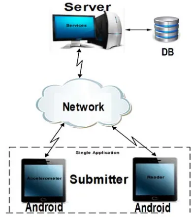
We present to you Safe Driving System using mobile systems. This system provides you with maps along with road condition notifications. The road conditions are updated using your mobile phones to provide real time road conditions to the cloud server, the system processes that data to refine the existing map data.
Safe Driving System collects the data from 3D-Accelerometer and updates it on server. 3D-3D-Accelerometer comes built-in most Android devices, it has 3 Axis, it collects X, Y, Z values and change in those values is uploaded with corresponding latitude and longitude. Data Mining is applied on all the collected data for particular location and results are derived out of it.
The derived result shows us the road condition. It helps us to detect bumps, potholes, speed Breakers and other roadway anomalies. The detected results are sent back to application in form of Alerts.
Thus this application assists driver throughout journey with road condition and helps driver by alerting him about upcoming road condition.
Keywords— Driving using Mobile, Safe Driving, Intelligent Driving, 3D accelerometer .
I.
INTRODUCTION
Over the years we have seen tremendous growth in the automobile industry as well as in the number of automobiles driven throughout. With this tremendous increase, road safety and accident prevention has become prominent aspects of driving.
The growth of automobile industry is seconded only by the growth in Telecomm Industry. Mobile phones have become a necessity instead of being a luxury. Our system tries to exploit this factor by using the data provided by the user, for the user.
Our system is based on the real time readings submitted to the cloud server by the user anonymously and in a transparent manner through the same Application used by the user for navigation and notification purposes.
The data provided to the user is dynamic and afresh in nature giving this system a defined edge over conventional navigational systems.
The data consists of 3D accelerometer and GPS readings. The 3D accelerometer readings are in 3 dimensions(X,Y,Z),X gives the change in forward/backward speed, Y gives the side movement of the device and Z gives the data about up and down movement(Bumps, breakers etc.).
The GPS readings consist of longitude and latitude data which provides the system with the position of the device/vehicle.
II.
PRIOR APPROACH
Current GPS navigation system deals only with maps which assists drivers only with the path to reach their desired destination. It also offers the user with different paths and user can select the most convenient path, driver can select path depending upon the distance, traffic or the path that requires the least travel time.
There are various navigators already available in the market such as Google Maps by google, Here Maps by Nokia and Map Connect by IPhone. These all applications concentrates on navigation between source location and destination location. These application provides user with different route options and user can select best one from it and can navigate to destination location.
480
Copyright © 2011-15. Vandana Publications. All Rights Reserved.
III. DRAWBACKS IN PRIOR
APPROACH.
Currently available navigation soft wares that are available in market does not provides any information regarding road conditions but this information is very important for a driver who is behind the wheels as he doesn’t knows the road condition and this might lead to a road accident.
Road condition changes climatically and regularly. These changes exacerbates the road condition. Most of the accidents takes place because of worse road condition. In recent years, there has been tremendous growth in smartphones which are now embedded with numerous sensors such as accelerometers, Global Positioning Systems (GPSs), magnetometers etc. These sensors can be used in different ways to make automobile sector safer and better.
It was recorded that in year 2010 around 1.4 million deaths were cause due to road accidents and these deaths can be controlled by implementing new techniques in the current maps and navigation system.
IV. OUR APPROACH.
Prior approaches focused on navigation for user from source location to destination location, none of the application focuses on driver safety or determining road condition.
In our approach, the system provides user with navigation as well as proper road conditions, it will inform user about the upcoming road conditions, pothole and bumps etc. prior to arrival of road anomaly. This system provides user a safe and mere comfortable journey by alerting user of upcoming anomalies.
In this system we will identify not only potholes but also bumps and rough, uneven, and smooth roads using multiple axes of the accelerometer. We also utilized a single measuring device rather than expensive external sensors placed in numerous places around the vehicle, which ultimately increases infrastructure costs. Our device, which is a mobile smartphone, contains GPS, microphones, and an accelerometer offering flexibility in methodology and user implementation. Encouraging results in identifying numerous road anomalies and sudden driving manoeuvres allows our system to evaluate an entire road’s condition and helps to assist drivers on unsafe characteristics, respectively, both of which are distinguishable factors that can determine safety on the road.
Fig. 1. The three-axis diagram of the accelerometer
Our system will basically take the current road conditions from the 3D accelerometer of user’s mobile and upload it to the server and this will be done for every user, then the gathered data will be used to obtain the result about the road condition which will be further displayed to the next user passing from that particular road , the provided results are obtained from machine learning.
481
Copyright © 2011-15. Vandana Publications. All Rights Reserved.
car should be configured to achieve accurate measurements. Likewise, driving behaviors vary from driver to driver, and performance may be exhibited as unsafe to some while safe for others. Providing quantitative data can help define a baseline in these instances. Every upload on server is kept anonymous and used only for mapping and machine learning techniques. For the driver to recognize these safety factors, we utilize audio feedback. This feature is easily implemented using Android API for speech and audio control.
V.
IMPLEMENTATION
Client Application:
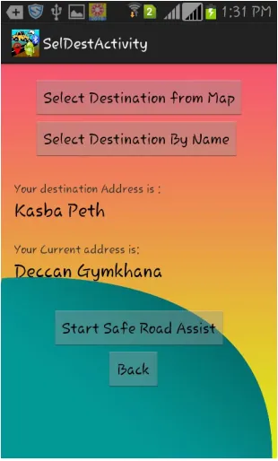
User first needs to download this app from play store into his smart phone and have to login or signup using personal details and he can even add few emergency contact numbers.
Then he/she needs to enter the current location and destination location into the app and then the app will provide the user with the improved maps and navigation with proper road condition.
Server Side:
As user installs this application, and he travels from one location to another the accelerometer of his phone will record any abnormality in the road condition and then it sends it to the server this will take place for each and every user passing from that any particular route.
Once ample amount of data is sent to the server, the server then mines the data to give desired output. Using different testing we can decide the threshold value till which database is updated and after threshold the system starts generating output. Once the threshold breaks the system starts generating output for next user application passing by.
Fig3:Flash Activity Page
Fig4 : Login Page
482
Copyright © 2011-15. Vandana Publications. All Rights Reserved.
Fig5: Signup Page
Fig6 : Start Road Assistance Page
Fig 7: Emergency Contact Page
483
Copyright © 2011-15. Vandana Publications. All Rights Reserved.
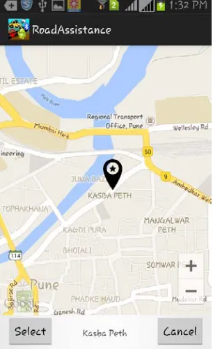
FIG 9: Select Destination
FIG 10:Routing Page
Using a mobile smartphone, we have demonstrated some innovative applications that are integrated inside an automobile to evaluate a vehicle’s condition, such as gear shifts and overall road conditions, including bumps, potholes, rough road, uneven road, and smooth road. Our road classification system resulted in high accuracy, making it possible to conclude on the state of a particular road. Along with these findings, an analysis of a driver behavior for safe and sudden maneuvers, such as vehicle accelerations and lane changes, has been identified, which can advise drivers who are unaware of the risks they are potentially creating for themselves and neighboring vehicles. The direction of lane change, as well as safe acceleration, compared with sudden acceleration, was easily distinguishable. Using a multiple-axis classification method for bumps increased the bump and pothole classification accuracy, resulting in a better road anomaly detection system. Being fuelled by demand, future advancements in embedded hardware will yield the smartphone and its sensors to be more powerful devices in terms of processing, sensitivity, and accuracy, paving the way for many more innovative applications. Unlocking its potential in intelligent transportation systems seems only logical as there are conceivably numerous of applications that can help reduce safety concerns on the road.
REFERENCES
[1] JAGADEESH, G.R., SRIKANTHAN, Tand QUEK, K.H. "Heuiristic techniques for accelerating hierarchical routing on road networks,"n: Intelligent Transportation Systems, IEEE Transactions, V61 3, No. 4, pp. 301 - 309, Dec. 2002.
[2] Y. Zhang, W. Lin, and Y.-K. Chin, “A pattern-recognition approach for driving skill characterization,” IEEE Trans. Intell. Transp. Syst., vol. 11, no. 4, pp. 905– 916, Dec. 2010.
[3] P. Varaiya, “Smart cars on smart roads: Problems of control,” IEEE Trans. Autom. Control, vol. 38, no. 2, pp. 195–207, Feb. 1993.
[4]“Traffic_Flow_Theory” http://www.tfhrc.gov/its/tft/tft.htm.
[5] Taylor, G.; and G. Blewitt, 2000. “Road Reduction Filtering using GPS”, Proceedings of 3rd AGILE Conference on Geographic Information Science, Helsinki, Finland, pp 114-120.