JOURNAL OF FOREST SCIENCE, 52, 2006 (4): 181–187
Remote sensing and image interpretation have been utilised in forestry management for many years. These methods can be applied in various tasks ranging from forest thematic mapping to the detailed tree or stand characteristics survey. Besides the advancement in digital aerial methods, high-resolution satellite sensors (e.g. Ikonos, QuickBird) are now available for operational use. However, the automated classification of such data is still prob-lematic due to greater spectral variations within one class (Halounová 2003).
Previous studies on high-resolution data (Blasch-ke, Strobl 2001) proved that traditional spectral-based methods result in rather poor or incorrect classification. Much information is contained in spatial relations of pixels and a few studies already showed the object-oriented approach promising when classifying VHR data (Baatz, Schäpe 1999; Leckie et al. 2003). The contribution of textural and structural information was also examined
(Hara-lick, Shapiro 1992; Brandtberg 1999) and vari-ous algorithms, such as co-occurrence matrix were applied to extract texture characteristics of trees (Zhang 2001). Neural networks (Gopal, Wood-cock 1996) and fuzzy classification improved the modelling of real-world dependences (Benz et al. 2004). Furthermore, increased use of a priori knowl-edge and information extraction become important with the rapid development of GIS.
This paper explores and demonstrates the capabil-ity of object-oriented image analysis software eCog-nition (Definiens Imaging, Germany) for the tree species classification from 4-meter Ikonos imagery. The combination of complex object description, hierarchical image object network and fuzzy system makes eCognition a challenge to knowledge-based image interpretation in a range of forestry manage-ment applications. Another project objective is to determine the appropriate scale and accuracy of species composition estimation using common
im-Supported by the Ministry of Agriculture of the Czech Republic, Project No. QG50097/2004 under the Research Program MZe 2005–2009.
Object-oriented classification of Ikonos satellite data
for the identification of tree species composition
F. Hájek
Faculty of Forestry and Environment, Czech University of Agriculture in Prague, Prague,
Czech Republic
ABSTRACT: This paper describes the automated classification of tree species composition from Ikonos 4-meter im-agery using an object-oriented approach. The image was acquired over a man-planted forest area with the proportion of various forest types (conifers, broadleaved, mixed) in the Krušné hory Mts., Czech Republic. In order to enlarge the class signature space, additional channels were calculated by low-pass filtering, IHS transformation and Haralick texture measures. Employing these layers, image segmentation and classification were conducted on several levels to create a hierarchical image object network. The higher level separated the image into smaller parts regarding the stand maturity and structure, the lower (detailed) level assigned individual tree clusters into classes for the main forest spe-cies. The classification accuracy was assessed by comparing the automated technique with the field inventory using Kappa coefficient. The study aimed to create a rule-base transferable to other datasets. Moreover, the appropriate scale of common image data and utilisation in forestry management are evaluated.
age data. The prospect of rule-base creation for the high-level automation in operational forestry is also discussed.
Site and field data collection
The research was conducted in man-planted for-ests nearby the town of Hrob (50o40´N, 13o43´E) in the Krušné hory Mts., Czech Republic. This submontane area consists of patches of mature spruce (Picea abies L.) and beech (Fagus sylvatica L.) forest, with the substantial proportion of larch (Larix decidua Mill.) and also young plantations of beech, birch (Betula pendula L.) and Picea pungens often mixed with Larix and Betula pubescens. The planted mature stands are mostly of the same age, but very heterogeneous in species composition, stocking density and canopy structure. Natural regeneration in addition to the planted trees some-times occurs. Silvicultural practices range from clear cutting to seed felling with heavy thinning on some spots.
Based on the previous information from LHPO forest inventory, twenty 400 m2 plots covering areas with 100% species composition were located as refer-ence data. The sample plot selection put an emphasis on size and class purity to provide a representative basis for accuracy assessment. The boundaries of each plot were determined by differential GPS SX BlueTM and PDA with ESRI ArcPadTM mobile GIS.
Imagery preprocessing
The Ikonos (Space Imaging, USA) image was acquired on 17th September 2003. Except for some hardwood species, most vegetation was still green and fully foliaged. Data were delivered in a geo-registered UTM projection (zone N33) with 11-bit radiometric resolution. The image contained a sig-nificant amount of clouds and atmospheric haze, so a 3 × 3 km subset of forested area with clear sky conditions was chosen for the analysis. There is also an important amount of shadow fraction through-out the scene associated with solar and observation angles (Table 1).
In the next step, the class signature space was enlarged by the calculation of additional channels. Foremost the single principal component was de-rived from original bands and then a median filter
(kernel sizes 3 × 3 and 5 × 5) was applied in order to suppress spatial frequency. Several Haralick (GLCM) texture measures were calculated and the contribu-tion to class separability was tested. The measures Mean, Variance and Homogeneity with window sizes of 3 × 3 and 5 × 5 were chosen. Further, layers calcu-lated by IHS transformation and edge detection (So-bel operator) were also applied in the classification.
Object-oriented analysis
After the signature space enlargement, image segmentation was performed to further handle high spectral variation and overlapping values of classes. In this phase, the image was split into smaller re-gions (object primitives) to simplify the complex data content thematically (Baatz et al. 2003). The classification was then performed using segments instead of single pixels.
Multiresolution segmentation
In the segmentation process, the size and shape of desired objects are defined by the calculation of heterogeneity between adjacent pixels, where Scale is the main input parameter. Shape factor (colour/ shape ratio) and spatial properties (smoothness/ compactness ratio) are other variables to define the homogeneity of object primitives.
Segmentation was conducted stepwise on sev-eral levels using different scales to construct the hierarchical image object network. The primary level was created using Scale parameter of 15. After preliminary classification, objects were merged by classification-based segmentation and the result (basic landuse classification) was re-imported into eCognition as a thematic layer. The sublevel was then segmented only within the area of interest (class Forest) using Scale parameter equal to 5. The finest objects with the Scale value of 3 were calculated at the third level applying the same approach.
[image:2.595.65.532.724.756.2]The Shape factor was set to a higher value for coarse segmentation and a lower value at the finer scale (higher influence of spatial properties). The two lower levels were processed using four Ikonos bands and median filtered channel of kernel size 3 × 3, the coarse landuse segments were made based only on thematic layer. Layer weights were set in relation to their standard deviations.
Table 1. Ikonos viewing and illumination geometry
Class definition
The three-level hierarchical image object network was used to delimit classes. Level 3 comprised basic “Landuse” types – Urban, Fields and Forest. This served to mask all non-forest areas. Lower level 2 “Forest” aimed to separate forest regions into Dense (young and mature stands with more or less closed canopies), Sparse areas and Clearcuts. Sparse forests mostly consisted of low stocking mature beech trees with the presence of visible ground. Detailed level 1 “Stand” was set to distinguish four main forest species in the area – Fagus, Picea, Larix and Betula. Further, structures of shadows and bare ground were classified on this level.
All classes of “Forest” level were also recognised at the lower “Stand” level for the purpose of post clas-sification improvement.
Classification
In order to create a distinct and fully transferable rule base, fuzzy logic membership functions were used to define object features. Fuzzy description enables classes to be assigned according to the mem-bership degree rather than crisp threshold values. The following features were applied:
– Object features: mean layer values (blue, red, NIR, brightness, GLCM mean 3 × 3, IHS, Sobel NIR), ratio layer values (blue, red), area generic shape feature;
– Class-related features: relative border to neigh-bour objects, relative area of sub-objects, exist-ence of sub-objects (super-objects);
– Customised features: NDVI, (red-green) vegeta-tion index, IHS/ brightness index.
Besides MF classification, preliminary nearest neighbour classification was done on the lowest level and features suitable to separate tree species were evaluated using a sample editor (histogram com-parison). The masking technique of determining the easy classes (ground, beech trees) at first and moving onto more difficult ones was often applied. Then the class boundaries were improved using class-related features and finally corrected by means of classifica-tion-based segmentation.
RESULTS
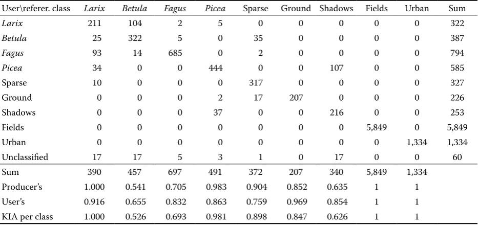
The classification accuracy was evaluated using field reference data. Sample areas were imported into the project by means of TTA mask (Definiens Inc. 2003) and the corresponding classes were linked to form a confusion matrix (Table 2). Several measure-ments such as Producer’s, User’s, Overall accuracy and Kappa index of agreement were derived for each class. Besides, classification reliability (Best clas-sification result) and stability within fuzzy concept were assessed.
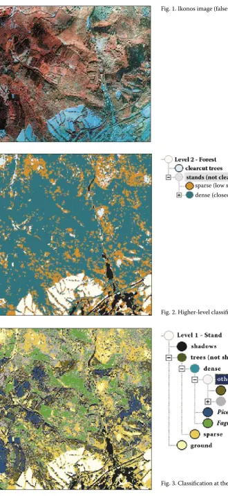
Fig. 1 shows the original image, Fig. 2 shows clas-sification on a higher “Forest” level. The result of classification at a lower “Stand” level is in Fig. 3.
[image:3.595.65.532.537.758.2]As indicated in the confusion matrix, the proposed method offered very good overall results. Both Pi-cea and Larix conifer species were classified with accuracy over 90%. Fagus achieved accuracy about 70%, which was caused by confusion with the class Sparse (a high proportion of beech trees). The most
Table 2. Error matrix of classification accuracy assessment. Overall accuracy is 0.945 with the Kappa index of agreement equal to 0.914
User\referer. class Larix Betula Fagus Picea Sparse Ground Shadows Fields Urban Sum
Larix 211 104 2 5 0 0 0 0 0 322
Betula 25 322 5 0 35 0 0 0 0 387
Fagus 93 14 685 0 2 0 0 0 0 794
Picea 34 0 0 444 0 0 107 0 0 585
Sparse 10 0 0 0 317 0 0 0 0 327
Ground 0 0 0 2 17 207 0 0 0 226
Shadows 0 0 0 37 0 0 216 0 0 253
Fields 0 0 0 0 0 0 0 5,849 0 5,849
Urban 0 0 0 0 0 0 0 0 1,334 1,334
Unclassified 17 17 5 3 1 0 17 0 0 60
Sum 390 457 697 491 372 207 340 5,849 1,334
Fig. 1. Ikonos image (false colour composite)
[image:4.595.71.402.48.766.2]Fig. 2. Higher-level classification
Fig. 3. Classification at the lower level
stands (not clearcuts)
problematic tree class was Betula, not only for the error matrix but also for classification reliability and stability. This tool estimating differences in member-ship degrees between the best and the second best class assignment shows that class Betula and class Larix often act as ambiguous. The two species have similar spectral and textural characteristics, espe-cially at young age. Besides, shadows are frequently confused or mixed with Picea pixels. The best results were obtained for all non-forest classes.
DISCUSSION
The results showed that the classification of 4-m Ikonos data could be performed with relatively high accuracy. The image allows to estimate the tree species composition at a sufficient scale. To get a satisfying outcome, additional channels must be calculated in the pre-processing phase and then included in segmentation and subsequent object-oriented classification. The object shape attributes are influenced by the kernel size and layer weight in the process of segmentation, the contribution of additional layers to classification was high for Sobel Edge detector, IHS transformation and low-pass fil-ters. The other texture measures had a lower impact on such spatial resolution data. The classification rules based on fuzzy membership functions are highly convertible, eCognition protocols developed in this project can be transferred and applied (with some threshold modification) to other datasets. To normalise the imagery band ratios can be employed, yet data acquired under fixed viewing and solar ge-ometry are recommended to use for the automated analysis.
Previous studies indicated that variations in image acquisition (different projection centres) became more problematic when analysing multitemporal aerial photos. Lower spectral, radiometric and tem-poral resolutions are also a drawback compared to VHR satellite data. However, the current lower price at a higher spatial resolution still accounts for aerial photography when developing the knowledge base for the method utilisation in forestry management. The necessary conditions to obtain good results are standardised screening plan and introduction of photography on IR material. The object-oriented analysis of aerial photos will be examined in further research.
Acknowledgements
I would like to thank my supervisor Lena Halou-nová from Remote Sensing Lab, Czech Technical
University in Prague, for her endless ideas and con-structive comments.
References
BAATZ M., SHÄPE A., 1999. Object-oriented and multi-scale image analysis in semantic networks. In: Proceedings of the 2nd International Symposium on Operationalization
of Remote Sensing, August 16–20th, International
Insti-tute for GeoInformation Science and Earth Observation, Enschede.
BAATZ M., BENZ U.C., DEHGHANI S., HEYNEN M., HÖLTJE A., HOFFMANN P., LINGENFELDER I., MIMLER M., SOHLBACH M.,WEBER M., WILHAUCK G., 2003. eCognition object oriented image analysis user guide. Munchen, Definiens Inc.
BENZ U.C., HOFFMANN P., WILHAUCK G., LINGENFEL-DER I., HEYNEN M., 2004. Multi-resolution, object-ori-ented fuzzy analysis of remote sensing data for GIS-ready information. ISPRS Journal of Photogrammetry and Remote Sensing, 58: 239–258.
BLASCHKE T., STROBL J., 2001. What’s wrong with pixels? Some recent developments interfacing remote sensing and GIS. GeoBIT/GIS, 6: 12–17.
BRANDTBERG T., 1999. Automatic individual tree-based analysis of high spatial resolution aerial images on naturally regenerated boreal forests. Canadian Journal of Forestry,
29: 1464–1478.
GOPAL S., WOODCOCK C., 1996. Remote sensing of for-est change using artificial neural networks. IEEE Control Systems Magazine, 8: 42–48.
HALOUNOVÁ L., 2003. Textural classification of B &W serial photos for the forest classification. In: Proceed- ings of the 23rd Symposium of European Association
of Remote Sensing Laboratories, June 2–5, 2003, Gent: 173–179.
HARALICK R., SHAPIRO L., 1992. Computer and Robot Vision, Vol. I. Chap. 9. Texture. Reading, Addison-Wesley: 453–494.
LECKIE D.G., GOUGEON F.A., WALSWORTH N., PARADINE D., 2003. Stand delineation and compo- sition estimation using semi-automated individual tree crown analysis. Remote Sensing of Environment, 8: 355–369.
ZHANG Y., 2001. A spectral and spatial information in- tegrated approach for object extraction from high-re- solution digital imagery. In: Second Digital Earth Conference, June 24–28, 2001, Fredericton.
Interpretace obrazových dat dálkového průzkumu země slouží již řadu let jako cenný nástroj v hospo-dářské úpravě lesa. Využití zahrnuje zejména lesní inventarizace, lesní tematické mapování, zjišťováni stromových a porostních charakteristik, zdravotní-ho stavu apod. Vedle rozvoje na poli digitální foto-grammetrie se do popředí dostávají také VHR sate-litní snímky s velmi vysokým rozlišením (Ikonos, QuickBird). Automatická klasifikace těchto dat je však z důvodu vysoké heterogenity v rámci zvolené třídy stále problematická.
Tradiční metody založené na analýze jednotli-vých pixelů ignorují texturu a prostorové vztahy v obrazu. Přitom důležitou sémantickou informaci nepředstavují pixely, ale smysluplné objekty s jejich vzájemnými vztahy a tedy segmentace a následná klasifikace obrazových objektů může být klíčem k úspěšné interpretaci. Práce navrhuje využití ob-jektově orientované analýzy ke klasifikaci vysoce texturovaných obrazových dat (Ikonos 4 m) pro účely identifikace lesní druhové skladby. Představe-ný software eCognition umožňuje komplexní popis vlastností objektů (spektrální, geometrické, textu-rální a kontextuální), tvorbu klasifikačního schéma-tu pro segmentaci obrazu a klasifikaci na několika úrovních hierarchické sítě objektů a definici přízna-ků pomocí „fuzzy“ pravidel.
Dosažené výsledky ukazují, že uvedená metoda umožňuje klasifikaci snímků Ikonos 4 m s relativně vysokou přesností (celková přesnost 0,945 a Kappa koeficient 0,914). Data disponují dostatečným pro-storovým rozlišením k určení dřevinné skladby lesa ve vhodném měřítku. Předpokladem pro úspěšnou klasifikaci je výpočet dodatečných kanálů v pří-pravné fázi a jejich využití v následných fázích segmentace a klasifikace obrazových objektů. Tvar a velikost objektů při segmentaci je ovlivněna ve-likostí posuvného filtračního okna a stanovenou vahou, detekce hran (Sobel operátor), IHS transfor-mace a mediánová filtrace zase výrazně přispívá ke zvětšení příznakového prostoru během klasifikace. Texturální míry lze při tomto rozlišení využít jen omezeně. Klasifikační „fuzzy“ pravidla vymezená funkcemi členství jsou velmi flexibilní, po úpravě prahů lze znalostní bázi přenést a celé klasifikační schéma aplikovat na jiná data pomocí vytvořených protokolů. Z důvodu normalizace lze doporučit po-užití poměrů pásem, nicméně pro automatickou analýzu je stále důležité, aby byly snímky pořízeny za obdobných akvizičních a světelných podmínek.
Satelitní snímky s velmi vysokým rozlišením představují nový obzor DPZ a proti leteckým sním-kům mají řadu výhod (vyšší spektrální, radiometric-ké a temporální rozlišení) pro využití v prakticradiometric-kém
Objektově orientovaná klasifikace satelitních snímků Ikonos pro účely
identifikace lesní druhové skladby
F. Hájek
Fakulta lesnická a environmentální, Česká zemědělská univerzita v Praze, Praha, Česká republika
ABSTRAKT: Studie popisuje automatickou metodu klasifikace dřevinné skladby ze satelitních snímků Ikonos s pro-storovým rozlišením 4 m za použití objektově orientovaného přístupu. Snímek zobrazuje oblast hospodářského lesa s podílem různých porostních typů (jehličnany, listnáče, smíšené) v Krušných horách v ČR. Z důvodu problematické klasifikace dat s velmi vysokým rozlišením (VHR) bylo třeba nejdříve zvětšit příznakový prostor jednotlivých tříd vypočtením dodatečných kanálů pomocí mediánové filtrace, transformace IHS a Haralickových texturálních měr. Tyto vrstvy byly potom použity k segmentaci obrazu a k následné klasifikaci na několika úrovních hierarchické sítě objektů. Vyšší úroveň měla za cíl rozčlenění obrazu na menší části podle věkové a prostorové struktury porostu, na nižší úrovni byly klasifikovány skupiny stromů do kategorií podle hlavních lesních dřevin. Přesnost klasifikace byla stanovena porovnáním výsledků s referenčními údaji z terénních šetření a výpočtem Kappa koeficientu. Cílem studie bylo vytvoření přenositelné znalostní báze, kterou bude možné využít pro automatickou klasifikaci snímků Ikonos 4-m. Dále bylo posouzeno rozlišení a měřítko vhodné k analýze dostupných typů obrazových dat DPZ a jejich použití v praxi hospodářské úpravy lesa.
lesnictví. Navíc odpadá problém s odchylkami sní-macích center při analýze dat v časových řadách. Cena za zobrazené území je však poměrně vysoká, a proto zůstávají barevné letecké snímky i nadále nejdostupnějším zdrojem obrazových informací. Předmětem další činnosti bude vytvoření objektově
Corresponding author:
Ing. Filip Hájek, Česká zemědělská univerzita v Praze, Fakulta lesnická a environmentální, 165 21 Praha 6-Suchdol, Česká republika
tel.: + 420 224 383 718, fax: + 420 234 381 860, e-mail: [email protected]