© 2019, IRJET | Impact Factor value: 7.211 | ISO 9001:2008 Certified Journal
| Page 1619
Optimum Band Selection in Sentinel-2A Satellite for Crop Classification
Using Machine Learning Technique
Pooja P. Jadhav
1, Prof. V.B. Deshmukh
21
Student, Dept. of Electronics & Communication, KLSGIT college Belgaum, Karnataka, India
2
Assistant Professor, Dept. of Electronics & Communication, KLSGIT college Belgaum, Karnataka, India
---***---Abstract - Mapping and identification of crops are vital for agricultural field management furthermore as for estimating
potential harvest. Having the similar spectral properties with different yields in the district and because of its complexities inside field is a difficult undertaking for mapping of the harvest utilizing satellite images. In the course of recent decades, in timberland checking, catastrophe the executives and agrarian applications satellite remote detecting has been playing a vital role. For surveying vegetation and soil properties some indices, for example, standardized contrast vegetation index (NDVI) and standardized distinction water index (NDWI) are utilized in satellite remote detecting applications that are prepared to do basically separating yield imperativeness and water pressure. These days to dissect grouping issues in horticulture, remote detecting capacities with high spectral, spacial and temporal resolution are accessible. As of late propelled Sentinel-2 satellite has thirteen spectral bands, quick return to time and goals at three diverse dimension (10m, 20m, 60m), just as the free accessibility of information, settles on it a decent decision for vegetation mapping. The fundamental target of this review is to investigate thecapability of Sentinel-2 satellite symbolism by executing AI calculations for yield characterization
.
Key Words
:
Sentinel-2, Remote sensing, Crop classification, Supervised classification, Machine learning.
1. INTRODUCTION
Harvest mapping assumes a significant job in maintainable farming practice and to manage the ecological difficulties because of environmental change and other main thrusts. Characterization of harvests gives basic data that is helpful in a different basic leadership process for overseeing rural assets. Satellite image processing can give convenient and exact data on yield type and dependable estimation of crop generation utilizing advance classification techniques. Up until now, a broadly utilized methodology in satellite remote detecting is to characterize different lists to encourage the arrangement of assorted land covers or plants under different anxieties (for example Standardized Difference Vegetation Index (NDVI) and Normalized Difference Water Index (NDWI)). NDVI can order land covers in remote sensing region, just as vegetation imperativeness while NDWI can evaluate water status by the blend of NIR and short wave infrared (SWIR) channel. Before, heaps of research have been led to connect these two lists with different records of intrigue (for example Vegetation Water Content (VWC), or Equivalent Water Thickness (EWT)) to produce a characterization guide of intrigue.
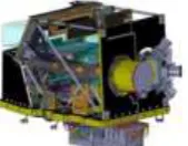
[image:1.595.260.345.674.740.2]For remote detecting applications, band data is of central significance in the period of satellite information investigation and elucidation. The dispatch of Sentinel-2A is a key piece of Global Monitoring for Environment and Security (GMES) program upheld by the European Space Agency (ESA) and European Commission (EC) guaranteeing a superior information congruity than other pertinent satellites, for example, SPOT and Landsat satellite arrangement, because of its high spatial goals and short return to time. To get more recovery data, its Multispectral Instrument (MSI) is a significant part on this satellite as appeared in Fig. 1. The MSI holds an anastigmatic telescope with three mirrors with a student breadth of about 150mm limiting canteen flexible contortions, and the optical structure has been advanced to accomplish best in class imaging quality over its 290km field of view. MSI additionally includes 13 phantom groups extending from visible, NIR to SWIR at various goals. This design is chosen as the best trade-off between client necessities and mission execution. Four bands at 10m resolution meet the fundamental necessities for land classification; six bands at 20m resolution give extra data on vegetation recognizing. The remaining three bands at 60m add to climatic and geophysical parameters.
© 2019, IRJET | Impact Factor value: 7.211 | ISO 9001:2008 Certified Journal
| Page 1620
In addition to qualities of remote sensing data, classification algorithms are important to improve classification accuracies of crop maps. As of late, random forests (RF) is a broadly utilized AI calculation comprising of a gathering of choice trees and it has been a very fruitful AI calculation for classification and regression. Additionally, support vector machine (SVM) has been generally connected for yield characterization. It's a fantastic classifier when the quantity of information highlights is extensive. Inside this structure, the fundamental point of the present examination is to assess the capability of Sentinel-2 information for harvest type characterization.
2. LITERATURE SURVEY
Rei Sonobe, Yuki Yamaya, Xiufeng Wang et al. [1] made a brief survey on yield grouping from sentinel-2 determined vegetation records utilizing outfit learning. From a land-arranging point of view, cropland assorted variety is fundamental and yield spread maps give data for evaluating potential reap and agricultural field management. Optical remote detecting is a standout amongst the most alluring alternatives since it offers vegetation indices and a few information have been distributed free of charge. Particularly, Sentinel-2A, which is outfitted with a multispectral sensor (MSI), offers some vegetation lists determined to survey vegetation status. Be that as it may, adequate thought has not been given to the capability of vegetation files determined from MSI information. Hence, 82 published indices were determined and their significance were assessed for classifying crop types. The examination territory was situated in the western piece of Tokachi plain, Hokkaido, Japan. Main cultivated crops types are beans, beetroots, grasses, maize, potatoes and winter wheat. In this study, the two most common classification algorithms, random forests (RF) and support vector machine (SVM), were applied to conduct cropland classification from MSI data. Furthermore, super learning was connected for greater improvement, accomplishing generally exactness of 90.2– 92.2% and critical contrasts were affirmed with the aftereffects of SVM and RF. Results demonstrated that vegetation records had the best commitments in distinguishing explicit yield types.
R. Saini, S.K. Ghosh [2] made a short study which expects to order crop utilizing single date Sentinel-2 symbolism. Determination of satellite symbolism for harvest characterization relies upon the components like image accessibility, decent variety level in yield types, and extensiveness of the examination region. Remote detecting datasets, for example, MODIS and Landsat have been used for vegetation mapping. The investigation territory is arranged at the lower region of Himalaya and farming assumes a noteworthy job in the economy of the region. The chose region is isolated into the eleven Land Use Land Cover (LULC) classes: High-thickness Forest, Low-Density Forest, Sandy territory, Water, Fallow land, Built-up, Orchard, Wheat, Sugarcane, Fodder and Other crops. Classification is performed by utilizing two most prominent and proficient machine learning algorithms: Random Forest (RF) and Support Vector Machine (SVM). In this, four spectral bands, i.e., Near Infrared, Red, Green, and Blue of Sentinel-2 satellite are stacked for the order. Results demonstrate that general precision of the order accomplished by RF and SVM utilizing Sentinel-2 symbolism are 84.22% and 81.85% separately. This exhibits the two classifiers performed well by setting an ideal benefit of tuning parameters, however RF accomplished 2.37% higher by and large exactness over SVM. Investigation of the outcomes expresses that the class explicit correctness of High-Density Forest achieves the most noteworthy precision while Fodder class reports the least exactness on the grounds among Wheat and Fodder crops as there is an intermixing of pixels.
Nicola Puletti, Francesco Chianucci, Cristiano Castaldi [3] led try utilizing sentinel-2 for forest classification in Mediterranean situations. Spatially-express data on forest composition gives significant data to satisfy logical, natural and the executives targets and to screen various changes in forest ecosystems. The as of late created Sentinel-2 (S2) satellite symbolism holds incredible potential for improving the classification of forest types at medium-extensive scales because of the simultaneous accessibility of multispectral bands with high spatial resolution and quick revisit time. In this, the capacity of S2 is tried for forest type mapping in a Mediterranean environment. Three operational S2 images covering diverse phenological periods (winter, spring, summer) were handled and investigated. Ten 10 m and 20 m bands accessible from S2 and four vegetation indices (VIs) were utilized to assess the capacity of S2 to segregate woods classifications (conifer, broadleaved and blended woodlands) and four timberland types (beech backwoods; blended spruce-fir backwoods; chestnut timberlands; blended oak backwoods). It was discovered that a solitary S2 picture procured in summer can't segregate neither the considered timberland classifications nor the backwoods types and in this way multitemporal pictures gathered at various phenological periods are required. The best arrangement yielded a precision > 83% with random forest algorithm in all thought to be forest types. Consequently, S2 can speak to a successful alternative for repeated forest monitoring and mapping.
© 2019, IRJET | Impact Factor value: 7.211 | ISO 9001:2008 Certified Journal
| Page 1621
Sentinel-2 time-arrangement information stack was consequently sectioned utilizing multi-resolution segmentation algorithm and the subsequent image objects were ordered utilizing the Time-Weighted Dynamic Time Warping (TWDTW) strategy. This methodology was applied to map wheat, maize, rice, sunflower and forest in a rural territory situated in the south-eastern piece of Romania. The executed cropland mapping structure yielded a general precision of 93.43%. It has the benefit of creating spatial vector dataset which can supports decision making in various agricultural management contexts.
Tianxiang Zhang, Cunjia Liu, Jinya Su, Wen-Hua Chen et al. [5] worked on band determination in sentinel-2 satellite for agribusiness application. Instead of classification based on indices, this explores direct classification using selected bands of sentinel-2A. In supervised learning, ground truth information is of imperative significance with the end goal that diverse methodologies can be assessed and looked at. Three techniques are analysed, where the primary methodology uses traditional indices and the last two methodologies adopt specific bands (Red, NIR, and SWIR) and full bands of on-board sensors, separately. It is demonstrated that a better classification performance can be accomplished by legitimately utilizing the three chose groups contrasted and the one utilizing indices, while the utilization of every one of the 13 groups can additionally improve the execution. Hence, it is prescribed the new methodology can be connected for Sentinel-2A image analysis and other wide applications. The proposed strategy can be applied to forest vegetation monitoring, vegetation physiological status recognizing and water system choices.
Katja Richter, Tobias B. Hank et al. [6] made a concise overview on Optimal Exploitation of the Sentinel-2 Spectral Capabilities for Crop Leaf Area Index Mapping. This spotlights on the assessment of spectral data content required for yield leaf region index (LAI) mapping in perspective on the future sensors. Information from a field battle were utilized to decide the optimal spectral sampling from accessible S2 bands applying reversal of a radiative exchange model (PROSAIL) with look-up table (LUT) and artificial neural system (ANN) approaches. Generally, LAI estimation execution of the proposed LUT approach (LUTN50) was practically identical regarding recovery exhibitions with a tried and affirmed ANN strategy. Utilizing seven-and eight-band blends, the LUTN50 approach got LAI RMSE of 0.53 and standardized LAI RMSE of 0.12, which was practically identical to the consequences of the ANN. Be that as it may, the LUTN50 strategy demonstrated a higher robustness and lack of care toward various band settings. Most every now and again chosen wavebands were situated in close infrared and red edge spectral regions. The outcomes accentuate the potential advantages of the Sentinel-2 mission for agricultural applications.
Darko Jaramaz, Veljko Perovic, Snezana Belanovic et al. [7] aimed to provide ESA Sentinel-2 Mission Vegetation Variables for Remote Sensing of Plant Monitoring. A principle job of ecological remote detecting to land resource management is its capability to outline vegetation resources and to screen changes that emerge over expanded timeframes. A few satellite missions have been propelled with the primary target of checking changes in the vegetation spread over the Earth surface (for example ENVISAT). Still today, most satellite based methodologies is situated towards recovering explicit vegetation parameters, for example, The Fractional Vegetation Cover (FVC), Leaf Area Index (LAI), Leaf chlorophyll content (Cab) and Fraction of Absorbed Photo-artificially Active Radiation (fAPAR). The point is to improve site-explicit vegetation management by recovering distinctive plant parameters as a contribution for the management measures; in motivations behind quick, proficient and non-dangerous observing of vegetation advancement. The ESA Sentinel-2 multispectral operational imaging mission will join a vast swath, frequent revisit, and orderly obtaining of all land surfaces at high-spatial resolution and with a large number of spectral bands. The most significant effect of Sentinel-2 for vegetation is relied upon to be the improved plant parameter (for example FVC, LAI, Cab and fAPAR), by joining three new spectral bands in the red-edge region which are focused at 705, 740 and 783 nm.
G. Kaplan and U. Avdan [8] proposed Mapping and Monitoring Wetlands Using Sentinel-2 Satellite Imagery. Mapping and checking of wetlands as one of the world's most profitable common asset has picked up significance with the improvement of remote detecting strategies. For this reason, three distinct methodologies were utilized, pixel-based, object-based and index based classification. Additional, for increasingly effective extraction of wetlands, a blend of object based and index based technique was proposed. It proposed the utilization of object based grouping for extraction of the wetlands limits and the utilization of Normalized Difference Vegetation Index (NDVI) and Normalized Difference Water Index (NDWI) for characterizing the substance inside the wetlands limits. At long last, an object based classification with a decision tree model has been produced for observing and mapping wetlands. Decision trees have generous points of interest for remote detecting characterization issues due to their adaptability, computational productivity and instinctive effortlessness. The majority of the utilized procedures were then looked at. For the index analysis and the pixel-based characterization ERDAS Imagine programming was utilized, while for the object based classification and the decision tree model, e-Cognition programming was utilized. As an examination territory Sakarbasi spring in Eskisehir, Turkey was picked. The exactness appraisal made for the utilized strategy gave estimation of 0.95.
© 2019, IRJET | Impact Factor value: 7.211 | ISO 9001:2008 Certified Journal
| Page 1622
information. For PolSAR information, Sentinel 1 double pol SAR information is utilized. Sentinel 2 multispectral information is utilized as optical data. Five land cover classes including two yield classes of the season are taken. Time series information over the period of one harvest cycle is utilized. Training and testing samples are estimated and gathered legitimately starting from the earliest stage the investigation locale. Three dimensional convolutional neural system (3D CNN) models, long short-term memory neural system (LSTM) models and convolutional long short-term memory neural systems (ConvLSTM) models are structured, used and assessed in crop classification task. Execution assessment is done based on both arrangement precision and speculation execution. LSTM based model have indicated predominant execution than 3D CNNs and ConvLSTMs in the both measures.
Markus Immitzer, Francesco Vuolo and Clement Atzberger [10] made a concise review on crop and tree species classifications in Central Europe utilizing sentinel-2 information. This displays the fundamental aftereffects of two classification practices surveying the abilities of pre-operational sentinel-2 (S2) information for mapping crop types and tree species. In the first case, a S2 image was utilized to outline summer crop species in Lower Austria just as winter crops/exposed soil. The second case intended to delineate diverse deciduous and coniferous tree species in Germany. Definite data about tree species appropriation is significant for forest management and to survey potential effects of environmental change. In this S2 information appraisal harvest and tree species maps were delivered at 10m spatial goals by consolidating the ten S2 spectral channels with 10 and 20 m pixel estimate. A directed arbitrary random forest classifier (RF) was deployed and trained with appropriate ground truth. In the two cases, S2 information confirmed its normal capacities to deliver dependable land cover maps. Cross-approved in general exactness ran between 65% (tree species) and 76% (crop types). This confirmed the high estimation of the red-edge and shortwave infrared(SWIR) bands for vegetation mapping. The object based image analysis (OBIA) and the established pixel-based classification accomplished equivalent outcomes, mostly for the cropland. As just single date acquisitions were accessible for this investigation, the maximum capacity of S2 information couldn't be evaluated.
Bing Wang, Kun Jia et al. [11] worked on evaluation of sentinel-2 MSI spectral band reflectances for assessing fragmentary vegetation spread. Fractional vegetation cover (FVC) is a basic parameter for portraying the land surface vegetation conditions and plays a significant role in earth surface procedure re-enactments and worldwide change studies. Along these lines, the goal of this was to survey the execution of Sentinel-2 MSI spectral band reflectances on FVC estimation. The samples, including the Sentinel-2 MSI overhang reflectances and relating FVC values, were simulated using the PROSPECT + SAIL radiative transfer model under various conditions, and random forest regression (RFR) technique was then used to create FVC estimation models and survey the execution of different band reflectances for FVC estimation. These models were at long last assessed utilizing field study information. The outcomes demonstrate that the three most significant groups of Sentinel-2 MSI information for FVC estimation are band 4 (Red), band 12 (SWIR2) and band 8a (NIR2). FVC estimation using these bands has a practically identical precision (root mean square mistake (RMSE) = 0.085) with that using all bands (RMSE = 0.090). The outcomes additionally exhibit that band 12 had a superior act for FVC estimation than the green band (RMSE = 0.097). However, the recently included red-edge bands, with low scores in the RFR model, have little centrality for improving FVC estimation precision contrasted with the Red, NIR2 and SWIR2 bands.
Jinzhong Kang, Hongyan Zhang, Honghai Yang and Liangpei Zhang [12] proposed support vector machine classification of crop lands utilizing sentinel-2 symbolism. Yield characterization makes it conceivable to acquire the spatial dispersion and planting region data of harvests. This aims to investigate the achievability of Sentinel-2 symbolism information for harvest type mapping and to assess the viability of Support Vector Machine (SVM) in separating different yield types utilizing a small training dataset. In doing as such, the established SVM classification strategy was applied to recognize significant yield types in Plymouth County, Iowa, USA, in view of Sentinel-2 time-series normalized difference vegetation index data. The outcomes demonstrated that the SVM model can successfully order three noteworthy yield types (corn, soybean and horse feed) in Plymouth with a general precision of >67% and a Kappa coefficient of 0.52, which assessed the capability of using SVM to get the spatial dissemination data of harvests dependent on the new Sentinel-2 imagery. In addition, this investigation of new information sources for crop classification can give some direction and the strategy can be applied to different areas.
© 2019, IRJET | Impact Factor value: 7.211 | ISO 9001:2008 Certified Journal
| Page 1623
decide the soybean and maize circulation in a region in Northeastern China. The classification exactnesses coming about because of this correlation demonstrate that the FFE technique beats MLC, and its correctnesses are like those of SVM and RF, with a general precision of 0.902 and a kappa coefficient of 0.846. This shows the FFE technique is a fitting strategy for yield classification to recognize crops with a comparable phenology.
[image:5.595.34.564.369.794.2]Tian-Xiang Zhang, Jin-Ya Su, Cun-Jia Liu and Wen-Hua Chen [14] made a study on potential bands of sentinel-2A satellite for classification problems in precisionagriculture. Numerous difficulties in accuracy farming can be tended by supervised classification, for example, crop type classification, malady and stress (e.g., grass, water and nitrogen) checking. Rather than performing classification based on designated indices, this explores direct classification using different bands information as features. Land cover classification by utilizing the as of late propelled Sentinel-2A picture is embraced to approve this strategy. Four methodologies of highlighted band determination are contrasted with characterize five classes (crop, tree, soil, water and road) with the support vector machines (SVMs) calculation, where the main methodology uses conventional empirical indices as highlights and the last three methodologies receive explicit bands (red, near infrared and short wave infrared) identified with indices, specific bands after ranking by mutual information (MI), and full bands of on-board sensors as features, individually. It is demonstrated that a superior characterization act can be accomplished by straightforwardly utilizing the chose bands after MI positioning compared with the one utilizing empirical indices and specific bands related to indices, while the utilization of every one of the 13 bands can imperceptibly improve the arrangement precision than MI based one. Accordingly, it is prescribed that this methodology can be applied for explicit Sentinel-2A image grouping issues in exactness horticulture.
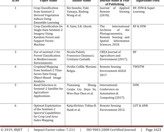
Table -1: Brief view of all the papers
Sl.No Paper Name Author Name Journal Name & Year
of Publishing Algorithms Used 1 Crop Classification
from Sentinel-2 Derived Vegetation Indices Using Ensemble Learning
Rei Sonobe, Yuki Yamaya, Xiufeng Wang et al.
Journal of Applied Remote Sensing (2018).
RF, SVM & Super Learning
2 Crop Classification On Single Date Sentinel-2 Imagery Using Random Forest and Support Vector Machine
R. Saini, S.K. Ghosh. The International Archives of the Photogrammetry, Remote Sensing and Spatial Information Sciences, 2018.
RF & SVM
3 Use of sentinel-2 for Forest Classification in Mediterranean Environments
Nicola Puletti, Francesco Chianucci, Cristiano Castaldi.
CREA Journal of Agriculture and Environment (2017).
RF
4 Cropland Mapping
from Sentinel-2 Time Series Data Using Object-Based Image Analysis
Ovidiu Csillik, Mariana Belgiu.
Remote Sensing Environment AGILE 2017.
TWDTW
5 Band Selection in Sentinel-2 Satellite for Agriculture
Applications
Tianxiang Zhang, Cunjia Liu, Jinya Su, Wen-Hua Chen et al.
International Conference on Automation & Computing (2017).
SVM
6 Optimal Exploitation of the Sentinel-2 Spectral Capabilities for Crop Leaf Area Index Mapping
Katja Richter, Tobias B. Hank et al.
Remote Sensing Environment 2012.
© 2019, IRJET | Impact Factor value: 7.211 | ISO 9001:2008 Certified Journal
| Page 1624
7 ESA Sentinel-2
Mission Vegetation Variables for Remote Sensing of Plant Monitoring
Darko Jaramaz, Veljko Perovic, Snezana Belanovic et al.
International Scientific Conference (2013).
Spectral Band Classification
8 Mapping and
Monitoring Wetlands Using Sentinel-2 Satellite Imagery
G. Kaplan and U. Avdan ISPRS Annals of the Photogrammetry, Remote Sensing and Spatial Information Sciences, 2017.
Pixel-based, Object-based, Index based classification.
9 Comparative Study On
Deep Neural Network Models for Crop Classification Using Time Series PolSAR and Optical
G. S. Phartiyal and D. Singh
The International Archives of the Photogrammetry, Remote Sensing and Spatial Information Sciences, 2018.
3D CNN, LSTM & ConvLSTM
10 Crop and Tree Species Classifications in Central Europe Using Sentinel-2 Data
Markus Immitzer, Francesco Vuolo and Clement Atzberger
Remote Sensing Environment, 2016.
Pixel-based classification & RF
11 Assessment of
Sentinel-2 MSI Spectral Band Reflectances for Estimating Fractional Vegetation Cover
Bing Wang, Kun Jia et al.
Remote Sensing Environment, 2018.
Random Forest Regression
12 Support Vector
Machine Classification of Crop Lands Using Sentinel-2
Jinzhong Kang, Hongyan Zhang, Honghai Yang and Liangpei Zhang
International
Conference on Remote Sensing 2018.
SVM
13 Crop Classification Based on a Novel Feature Filtering and Enhancement Method
Limin Wang, Qinghan Dong, Lingbo Yang, Jianmeng Gao and Jia Liu
Remote Sensing Environment, 2019.
MLC, SVM & RF
14 Potential Bands of Sentinel-2A Satellite for Classification Problems in Precision Agriculture
Tian-Xiang Zhang, Jin-Ya Su, Cun-Jia Liu and Wen-Hua Chen
International Journal of Automation and Computing (2018).
SVM
3. CONCLUSIONS
© 2019, IRJET | Impact Factor value: 7.211 | ISO 9001:2008 Certified Journal
| Page 1625
expanded the selectivity of information, yet has prompted more prominent information volume and data repetition. It will be extremely significant to select the images that assumes a significant role to crop classification in such a large number of time-series images. The second is the improvement of spatial resolution, which makes the image show progressively detailed data and is helpful for fine order and measurements. Then, high spatial resolution likewise encourages all the more fine-grained division of yields, bringing about better outcomes.
REFERENCES
[1] Rei Sonobe, Yuki Yamaya, Xiufeng Wang et al. “Crop Classification from Sentinel-2 Derived Vegetation Indices Using Ensemble Learning”, Journal of Applied Remote Sensing Vol (12) (2018).
[2] R. Saini, S.K. Ghosh, “Crop Classification On Single Date Sentinel-2 Imagery Using Random Forest and Support Vector Machine”, The International Archives of the Photogrammetry, Remote Sensing and Spatial Information Sciences, Volume XLII-5, 2018.
[3] Nicola Puletti, Francesco Chianucci, Cristiano Castaldi, “Use of sentinel-2 for Forest Classification in Mediterranean Environments”, CREA Journal of Agriculture and Environment (2017).
[4] Ovidiu Csillik, Mariana Belgiu, “Cropland Mapping from Sentinel-2 Time Series Data Using Object-Based Image Analysis”, Remote Sensing Environment AGILE 2017.
[5] Tianxiang Zhang, Cunjia Liu, Jinya Su, Wen-Hua Chen et al. “Band Selection in Sentinel-2 Satellite for Agriculture Applications”, International Conference on Automation & Computing (2017).
[6] Katja Richter, Tobias B. Hank et al. “Optimal Exploitation of the Sentinel-2 Spectral Capabilities for Crop Leaf Area Index Mapping”, Remote Sensing Environment 2012.
[7] Darko Jaramaz, Veljko Perovic, Snezana Belanovic et al. “ESA Sentinel-2 Mission Vegetation Variables for Remote Sensing of Plant Monitoring”, International Scientific Conference (2013).
[8] G. Kaplan and U. Avdan, “Mapping and Monitoring Wetlands Using Sentinel-2 Satellite Imagery”, ISPRS Annals of the Photogrammetry, Remote Sensing and Spatial Information Sciences, Volume IV-4/W4, 2017.
[9] G. S. Phartiyal and D. Singh, “Comparative Study On Deep Neural Network Models for Crop Classification Using Time Series PolSAR and Optical”, The International Archives of the Photogrammetry, Remote Sensing and Spatial Information Sciences, Volume XLII-5, 2018.
[10] Markus Immitzer, Francesco Vuolo and Clement Atzberger, “Crop and Tree Species Classifications in Central Europe Using Sentinel-2 Data”, Remote Sensing Environment, Vol (8) 2016.
[11] Bing Wang, Kun Jia et al. “Assessment of Sentinel-2 MSI Spectral Band Reflectances for Estimating Fractional Vegetation Cover”, Remote Sensing Environment, Vol (10) 2018.
[12] Jinzhong Kang, Hongyan Zhang, Honghai Yang and Liangpei Zhang, “Support Vector Machine Classification of Crop Lands Using Sentinel-2”, International Conference on Remote Sensing 2018.
[13] Limin Wang, Qinghan Dong, Lingbo Yang, Jianmeng Gao and Jia Liu, “Crop Classification Based on a Novel Feature Filtering and Enhancement Method”, Remote Sensing, Vol (11) 2019.