RESEARCH ARTICLE
A NUMERICAL STUDY OF THERMOCLINE (CASE STUDY: PERSIAN GULF)
* Mehdi Delphi
Department of Civil Engineering and Water, Shoushtar Branch, Islamic Azad University, Shoushtar, Iran
ARTICLE INFO ABSTRACT
Persian Gulf, as an important biological aquatic basin in Middle East, joints via Hormoz Strait to Oman Sea and Indian Ocean. Tide, wind, precipitation, solar radiation and evaporation are main phenomena regarding the oscillation trend of water quality variation in mentioned basin. Moreover, the flow entrance from Arvand River to Persian Gulf influences aforesaid phenomenon, extensively. This research bases on Mt. Mitchell statistics collected in NOAA research vessel observation through the Persian Gulf, Strait of Hormoz and Gulf of Oman. Investigating the variation of shallow water conditions in aforesaid aquatic basin; we analyzed the regional observations and measurements in comparison with the output of a numerical model which has been developed based on Navier Stokes partial differential equations. The results argue that baroclinicity and stratification of fluid column are two important events occur and change in Persian Gulf seasonally. Based on our obtained results, we are convinced about creation and existence of more baroclinicity and turbulence in north-eastern coasts of this aquatic basin in comparison with deeper parts; and this event originates from effects of internal flow from Arvand River, related bed stresses and situation and direction of wind sources. Also the
results showed, by applying north-western wind in winter to summer transition period, the fresher
inflow can penetrate much further into the Gulf and lack of wind induced mixing and solar radiation that lead to the thermocline formation and its development from winter to summer.
Copy Right, IJCR, 2011, Academic Journals. All rights reserved
INTRODUCTION
The thermocline is a thin distinct layer of rapid temperature which separates the upper mixed layer from the calm deep water below. Recent observations have revealed an important inter-annual to longer term extra-tropical thermocline variability, associated with sea surface height (SSH) anomaly propagation towards west at most latitudes. Productivity is low where the thermocline is stable and well developed and high where it is broken by stirring and upwelling. Thermocline depends on the balance between heat input and turbulence generated by the tides and wind. The variable heat input that occurs during summer is important in relation to the surface temperature, but it is relatively less important for deeper waters since the stability created during heating effectively prevents vertical heat exchange. However, a rise in the temperature of water surface coupled with increase of wind speed would increase evaporation and mixing which increases salinity reducing stability and vertical mixing. If stratification is relatively weak due to high salinity, induced by strong evaporation; thus, thermocline is much deeper than in other oceans.Semi-enclosed seas are particularly interesting
*Corresponding author: [email protected]
dynamically because they are subjected to many of the same forcing as the coastal oceans, having both near shore and mid-sea dynamical regimes, and have a variety of associated mesoscale phenomena. Excessive evaporation and lake of precipitation (especially in subtropics) make them very saline that can lead thermocline circulation between them and open sea. Surface forcing as wind stress over these water bodies can change seasonally that lead to substantial annual variation. As the outflow of the semi-enclosed sea enters open Ocean it can increase the salinity of the thermocline. For example as the Persian Gulf outflow increases the salinity of the Oman Sea at the thermocline by approximately 5 PSU (practical salinity unit) throughout the thermocline, before reaching the western part of the Indian Ocean. The salinity levels within the neighboring thermoclines are also maintained by the regional excess of evaporation over precipitation. In the Persian Gulf thermal stratification is influenced by the weather conditions and river inflow into the sea. Thermocline formation and its thickness depend on topography of ocean and meteorological factors. In fact, formation and thickness of stratification trend are dependent on internal hydrodynamic mechanisms [1]. The freshwater input is mainly from the Arvand river estuary with a minor contribution from the Iranian rivers in the north. This large estuary runs in a southern direction into the Persian Gulf.
ISSN: 0975-833X
International Journal of Current Research
Vol. 3, Issue, 11, pp.194-201, October, 2011
INTERNATIONAL JOURNAL OF CURRENT RESEARCH
Article History: Received13th
June, 2011 Received in revised form 17th
July, 2011 Accepted 27th
September, 2011 Published online 15th
October, 2011
Key words:
Sea Surface Height (SSH), Practical Salinity Unit (PSU), Averaged Monthly Wind (AMW), Arvand river,
Wind sources, Stokes partial,
The water at its mouth may reach a distance of 5 km inside the Gulf. This river can store up about 5 x10⁹m3nutrient rich freshwater into the Persian Gulf each year [2]. The Persian Gulf is about 990km long and has a maximum width of 370km with an average depth 36m. The Persian Gulf occupies a surface area of about 239000 Km2 [5]. The Persian Gulf is a semi-enclosed shallow sea situated in an arid zone where evaporation greatly exceeds precipitation and river runoff. In addition to its large contribution in the heat budget, evaporation rates play an important role in maintaining the circulation of the Gulf. The main body of the Persian Gulf water is separated from the OmanSea by the Strait of Hormuz. Tides, wind stress, evaporation and water exchange with the OmanSea are some effective factors to form thermocline. One of the main sources of data for this semi-enclosed sea, including temperature, density and salinity measurements is Mt.Mitchell cruise which was carried out in summer and winter 1992 during 100 days from Feb. to Jul. In this study, we evaluate the thermocline formation and its axis displacement through water column in the Persian Gulf numerically while using some observational data. The aim of this paper is to study thermocline development in northern part of the Persian Gulf due to the forcing of wind, evaporation, solar radiation and river inflow and water exchange through the Strait of Hormuz numerically. The development of thermocline in the Persian Gulf from winter to summer is a tool to reveal some physical mechanisms in this semi-enclosed sea. In this paper we try to model thermocline development under influence of the forcing in the Northern part of the Persian Gulf.
Analyzing Measured data
The Persian Gulf that is completely shallow shaped like a bottle and spread from northwest to southwest. Its length is about 917 KM and the maximum width is 338 KM. It should be noted that Tigris and Euphrates rivers are coming into PG.Waveproperties, mechanisms and currents are different in theupperwater column inbothsummerandwinter seasons. in summer, thermocline formed all over the PG, in fact the stratification of fluid water is severely high.Salinityin the Persian Gulfis more thanOmanSea; therefore the deep currents Occur from PG to OBefore the model results are presented some observations on the Temperature, Salinity and Sigma-T fields for the Persian Gulf based on the ROPME Mt. MitchellCruise (winter and summer of 1992) are presented. Fig.1 shows a map of the Persian Gulf which is approximately 900km in the east-west and 300km in the north-south, [47-57] ºE, [24-30] ºN. The analyses are based on the CTD data (temperature, salinity and density as a function of water depth) for winter and summer1992. Using temperature, salinity and density data we have made cross sections of their fields along the PG axis for winter and summer. Fig.2 shows contours of temperature, density and salinity (T, D and S) in a cross section along the axis of 15-106 stations of the PG with colder water on the left as a result of the Arvand river inflow in winter. A part from the Strait of Hormuz region where the exchange flow occurs all the time and a small region near the head of the gulf in which the river inflow creates stratification, there is almost no vertical stratification in the water column and it appears to be uniform in density. As it could be seen in winter most of the northern part of the Gulf becomes vertically mixed, with maximum density and highest salinity of the
[image:2.612.314.554.168.315.2]Saudi coast. This dense water finds its way to deeper levels in the stratified areas towards the entrance of the Persian Gulf [4]. However in summer time the thermocline is well established and extends well into the gulf. The main reasons for the formation of the thermocline in summer are strong solar heating and more importantly the reducing northwesterly winds which are very strong in winter time. During summer the layer below the thermocline is similar in character to the deep water in winter. Above the thermocline the temperature in summer is also much higher.
Fig. 1: Map of the Persian Gulf and ROPME stations
Summer thermocline creates strong stratification near the surface leading to a strong barrier against the vertical exchanges between the surface water and deeper regions. The strong temperature gradient under surface layer well inside the Persian Gulf represents existence and formation of seasonal thermocline inside the PG. Thermocline always exists in the Strait of Hormuz because of continuouswater exchange between the Persian Gulf and the Gulf of Oman. The densest water is found in the shallows around Bahrain with values of ρ> 1033 kg/m3. Bottom waters in the Southern Shallow areas
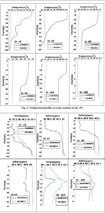
do not display elevated densities compared with ambient bottom waters and, therefore, do not significantly contribute to the driving of the dense bottom outflow in summer [6]. Fig.3 shows temperature profiles in some stations in winter and summer and it is very clear that the thermocline in some stations in summer is very strong with temperature change of typically a few degrees (e. g. 4 to 6 degrees centigrade over a depth change of about 10 m). However in winter there is uniformity in temperature profile from surface to bottom inside the PG. As it could be seen in the below T-D curves, variations of temperature with depth is not considerable through the water column in winter while a negative gradient with depth takes place under surface layer in summer, representing summer thermocline formation; so seasonal thermocline could be formed in whole of water in the Persian Gulf during summer. Then variation in salinity with depth in the above stations is shown in Fig.4. Salinity variations in water column for the above measurement stations have fluctuations with depth in summer in spite of uniformity in winter as a result of thermocline formation only in summer. According to the temperature diagrams in [11], variations of T with depth represent vertical gradients in temperature in summer could be due to thermocline development and vortex motions in the PG despite of in winter. This is particularly marked in summer profiles. Also in [12], thermocline doesn’t form in the Persian Gulf in winter despite its forming in
summer. Of course in the Strait of Hormuz as a result of water exchange with the OmanSea, thermocline forms in winter too. Development of thermocline from winter to summer is a process that depends on some climatic factors such as evaporation, wind and solar radiation which seem to have been important in semi enclosed seas. Salinity variation in the Strait of Hormuz is not uniform as it could be seen for station 16. Also near the Arvand river to the Persian Gulf (as in stations 103 and 109) as a result of river inflow and salinity gradient, there is an increase in salinity with depth in winter too.
The Numerical Approach
To highlight the physical mechanisms of temperature and salinity variations and so thermocline development from
winter to summer, we have run POM. The governing equations are the three-dimensional Navier-Stokes equations under the hydrostatic, Boussinesq approximations in the
-coordinate system.Boundary and Initial Conditions
[image:3.612.120.505.49.545.2]To run the model, averaging T and S variations from surface to bottom in the water column for some of measurement stations, profiles of these two parameters were as the following relations in terms of depth (z) for initial point of running at first. The main run of the model is initialized in winter when stratification is weak throughout the Persian Gulf. Furthermore, interpolating among most of stations for temperature and salinity by the cressman method (an
Fig. 3: Temperatureprofiles at some stations in the PG
Fig. 4: Salinity profiles at some stations in the PG
(through three zones as it mentioned in Fig. 1)
instrument for interpolating physical data in some stations to all other ones, inverse of distance square, 1/r2), temperature
and salinity files were prepared for winter and summer.
(1) (2)
Interpolation among the stations for T and S could be obtained by following equations:
(3)
(4)
Where the ri is distance of ith point from the desired point.
Starting to run the model from the above T and S profiles for whole of the Persian Gulf and zero initial values of the forcing (wind stress, solar radiation and evaporation) in time steps of 5 minutes, 6 months running to surface layer of interpolation in winter provided the start of the main run to summer for the second stage of the model running. In fact 6 months running before winter with initial zero forcing and factors to winter (with real values of all forcing in winter according to Meteorological data) established stability. As the main part of the research, running from winter conditions to summer
surface temperature and salinity (interpolated by cressman method) as the final purpose was done for 6 months and 5 minutes time step. The files of surface T and S of summer interpolating among most of measurement stations in summer were the final purpose after 6 months running from winter to summer. In the second 6 months running, evaporation rate, wind stress, solar radiation, Arvand river current to the Persian Gulf and water current from the Oman sea to the Gulf through the Strait of Hormuz varied from winter values to summer ones according to the Meteorological data [8].
Table1:Climatological data used in the model
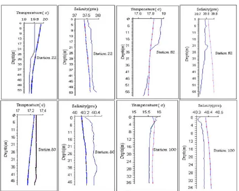
[image:5.612.71.542.43.420.2]Figure 5 presents the comparison the measurement and model data are shown against depth in winter (at start point of the model run) in some stations. According to the figure 5, we don’t observe big difference between each two physical
[image:5.612.321.537.587.675.2]Fig. 6: Comparison of temperature and salinity obtained from model and measured values at the latitude 28 degrees.
properties along water column in the stations. As we know, some forcing such as wind stress, Arvand river to the Gulf in northwest, solar radiation, water deby from the Oman sea through the Strait of Hormuz in a layer of about 60m thickness from surface and evaporation effect on temperature variations in the water column and cause thermocline formation in the Persian Gulf in summer. In this research, we employ the
Fig. 7: Comparisonof temperatureand salinityobtained frommodeland measured values at the latitude29.3degrees
monthly average of wind velocities at 10m height above sea surface,
U
10, according to the Meteorological data. The surface wind stress is calculated using the bulk transfer formula:(5)
[image:6.612.274.517.45.629.2]Where
a is the density of air (equals to 1.225 in theresearch),
U
10 is the 10m wind speed. Following [9], the dragcoefficient,
C
D used in the wind stress is given by (for winds velocities less than 8 (m/s) measured in a 10 meter height):In fact, dominant wind velocity on water basins is measured in a height of 10 (m) of the surface because of wind friction with water. The other forcing affecting on the Persian Gulf, the Arvand river outflow originates with an angle 350 rather than horizontal arriving in the northwest of the Gulf. The annual mean debies for river outflow are 0.594 and 0.294 in winter and summer, respectively. The governing equations are solved using finite difference method in POM code in 216
100
11 grid points with horizontal resolution of 6.5km ( and vertical resolution of . The sidewalls are assumed to be rigid with 3m in depth avoiding numerical errors running the POM code. The model is run from winter with ROPME 1992 (A cruise done by the Italian ship, Mt. Mitchell in the Persian Gulf in 100 days during winter and summer, 1992 through 112 stations, measuring T, S and other physical parameters of the water) data and a time-step of 300s under wind stress, solar radiation, evaporation and water exchange with Arvand River and the Oman Sea. The open boundary conditions in east in the Strait of Hormuz is appointed with temperature and salinity varying homogeneously from surface to depth of 60m of the inflow plume from the Oman sea and a deby of water equal to 0.53SV in winter and 0.42SV in summer. In order to run the model from winter to summer, monthly average of wind velocity, solar radiation and evaporation climatological data used in modeling the thermocline development from winter to summer in this research are as shown in Table 1.Results of the Simulations
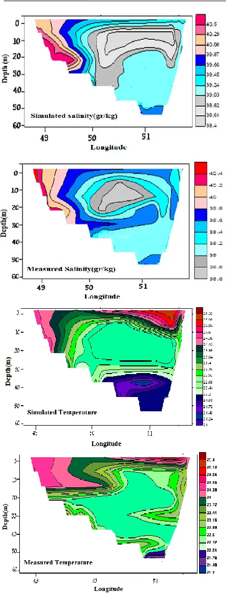
As it could be seen in the contours of temperature in summer in spite of in winter, seasonal thermocline would be formed in the Persian Gulf in summer. This phenomenon is related to how the factors vary from winter to summer there. In fact, an important implication from the above findings is that changes in the thermocline temperatures are related to the Arvandriver current to the PG in the northwest. It is clear that the model represents thermocline development from winter to summer, the output of the model shows thermocline formation in northwest of the PG in summer despite in winter too. Thermocline as a negative gradient of temperature in sub-layer expressing stratification in the Persian Gulf. Thermocline formation in the PG in summer despite in winter develops from winter to summer influenced by climatic parameters like evaporation and solar radiation and wind stress varying from winter to summer; river inflow in northwest and current inflow in the Strait of Hormuz in east of the case zone influence on stratification and temperature gradient. After interpolating the temperature and salinity for 29 indexed stations into the model grid in the case study zone, the initial conditions (winter balance conditions)were determined. The model performed for six months with apply the wind, evaporation and radiation forces monthly, also the inlet currents of Oman sea and Arvand river to PG until summer considered in thisprocess. The amounts of atmospheric forces ( wind stress, solar
radiation and evaporation) also inlet currents from Oman sea with 60 m of thick and 1.5 m for inlet currents from Arvand river are are changed along the model run and per each time step (default time step is 300 sec.) from winter to summer. And these values will be modified at the next time step. The variation of forces and stresses that existed in the case study zone at each time step compared to previous step will be changed based on the different of Stress or forceintwoconsecutive months divided to the amount of time steps in a month.To ensure theaccuracy ofthe model results and Comparewith reality, temperature and salinity contours in the latitude of 28 degree and 29.3 degree that obtained from model run on mode Averaged Monthly Wind (AMW) including all forces will be analyzed as shown in below: The Correlation coefficients between model results and measured data at the latitude 28 degrees are 0.806 for temperature and 0.762 for salinity also these values at the latitude 29.3 degrees are 0.899 for temperature and 0.809 for salinity. According to themodelassumptions these resultsare acceptable.
Conclusion
As we could see in the temperature and salinity diagrams through longitudinal and latitudinal transects in the Persian Gulf, thermocline can form in summer in spite of winter in whole water of the PG. Numerical modeling of temperature variation from winter to summer shows that river currents of the Arvand, wind stress and evaporation in the northern part of the zone have caused thermocline to be developed so that seasonal thermocline form. Thermocline forms in the Strait of Hormuz during seasons of year because of water exchange between the Persian Gulf and the Oman sea, while as time closes to summer, thermocline extends to north of the Gulf. The Persian Gulf water in Arabian coasts (south of it) is more salty rather than in Iranian coasts (north of it) in summer and it is resulted from higher temperature and shallower water in south of the Persian Gulf and that, salts are taken out of water while evaporating. There is a rather more stable layer with a large temperature gradient as in [7], for thermocline and mixed surface layer influenced by wind stress in the PG in summer. The model results show that the thermocline starts to develop with slow rate but intensify at the beginning of the summer. This is the case for monthly averaged wind and the maximum vertical temperature gradient occurs in July. According to the obtained results from the model run on AMW mode we reached the result that besides forces and other factors thermal structure and thermocline formation isaffected bywind stress and solar radiation (with low wind) on the Persian Gulf surface is an important factor for formation and development thermocline at this zone. Therefore running the model with AMW mode has a good agreement with reality and ismore desirable.
Acknowledgements
for many useful suggestions in improving the quality of this work.
REFERENCES
1. AbdEllah, R. G. E., 2009, Thermal Stratification in Lake Nasser, Egypt Using Field Measurements. J. of World
Applied Sciences, Vol. 4, pp. 546-549.
2. Al-Asadi M. S., Talal A. M. and Hreeb K. K., 2007, some ecological studies onHydrophytes from Shatt Al-Arab River. J. of Oceans and Oceanography, Vol. 2, No.1, pp: 61-68.
3. Bidokhti, A. A. and Ezam, M., 2008, The structure of the Persian Gulf outflow Subjected to density variations. J.
of Ocean Sci. Discuss, Vol. 5, pp. 135-161.
4. Brewer, P.G., Fleer, A.P., Shafer, D.K., Smith, C.L., (1978), Chemical oceanographic Data from the Persian Gulf and Gulf of Oman, WHOI Technical Report WHOI-78-37, 105 p.
5. Emery K. O. 1956. Sediment and water of the Persian Gulf, AAPG Bull., Vol. 40,pp: 2354-2383.
6. Kampf J. and M. Sadrinasab, 2006. The circulation of the Persian Gulf: a numerical Study, J. of Ocean Sci., Vol. 2, pp: 27-41.
7. Kundu P.K. and I.M. Cohen, 2002, Fluid Mechanics, Second Edition, Academic Press, USA, 766p.
8. Lvov Y. and Tabak E., 2001, Hamiltonian formalism and the Garrett-MunkSpectrum of internal waves in the ocean, J. of Prl,Vol. 87, pp: 1-5.
9. Matsuya and Honda, 1982, Wind-induced growth of water waves. J. of FluidMech., Vol. 123, pp: 425-442.
10. Mellor G.L., 2003, Users guide for a three-dimensional, primitive equation, numerical ocean model, P. Amos. Ocean. Sci., Princeton University.
11. Mosaddad S. M., A. Bidokhti and H. Basirparsa, (2009), Development of Summer thermocline in the Persian Gulf, J. of Climate Change: Impacts and Responses, Melbourn Univ. press, Vol. 1, 8p.
12. Swift, S.A. and A.S. Bower, (2003), Formation and circulation of dense water in the Persian Gulf, J.of Geophysics. Res., Woods Hole Oceanographic institution, Vol. 108.